Bridge Statistics for South Greensburg, Pennsylvania (PA)
Condition, Traffic, Stress, Structural Evaluation, Project Costs
- National Bridge Inventory (NBI) Statistics
- 11Number of bridges
- 36ft / 10.9mTotal length
- $2,148,000Total costs
- 95,368Total average daily traffic
- 7,849Total average daily truck traffic
- National Bridge Inventory (NBI) Registered Bridges for South Greensburg
- No street view available for this location
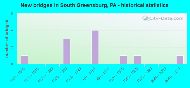
- New bridges - historical statistics
- 11900-1909
- 31930-1939
- 41950-1959
- 11970-1979
- 11980-1989
- 12010-2019

- Reconstructed bridges - Historical Statistics
- 11940-1949
- 01950-1959
- 01960-1969
- 01970-1979
- 11980-1989
- 01990-1999
- 12000-2009
- 12010-2019


- Bridge Condition - Deck
- 11.1%Excellent
- 11.1%Very good
- 22.2%Good
- 22.2%Satisfactory
- 11.1%Fair
- 11.1%Poor
- 11.1%Critical

- Bridge Condition - Superstructure
- 11.1%Excellent
- 11.1%Very good
- 22.2%Good
- 11.1%Satisfactory
- 44.4%Fair

- Bridge Condition - Substructure
- 11.1%Excellent
- 22.2%Good
- 22.2%Satisfactory
- 33.3%Fair
- 11.1%Poor

- Bridge Condition - Channel
- 11.1%Very good
- 22.2%Good
- 22.2%Satisfactory
- 33.3%Fair
- 11.1%Poor
Find on map >> Show street view
Structure Number: 35936, Location: HEMPFIELD TOWNSHIP (Lat: 40.283956, Lng: -79.541908), Route carried "on" structure: US 30, Year Built: 1959, Year Reconstructed: 1989, Status: Open, Structure Length: 1.31m (4.30ft), Average Daily Traffic: 40,662 (year 2021), Truck Traffic: 6%, Average Future Daily Traffic: 30,091 (year 2032), Design Load: HS 25 or greater, Features Intersected: Gibralter Way (T-941)
Minimum Vertical Clearance: 30+ m (98+ ft), Kilometerpoint: 23.926, Lanes on structure: 4, Lanes under structure: 2, Base Highway Network: Yes, Owner: State Highway Agency, Approaching Roadway Width: 21.3m (69.9ft), Skew: 30 degrees, Material/Design: Prestressed concrete, Design/Construction: Box Beam or Girders - Single/Spread, Number Of Spans In Main Unit: 1, Length of Maximum Span: 12.8m (42.0ft), Curb or Sidewalk Widths: Left: 0.2m (0.7ft), Right: 0.2m (0.7ft), Curb-To-Curb Width: 21.6m (70.9ft), Out-to-Out Width: 22.4m (73.5ft)
Condition: Deck: Satisfactory, Superstructure: Good, Substructure: Satisfactory, Inventory Rating: 63.5 metric tons, Method Used To Determine Inventory Rating: Load Factor (LF), Structural Evaluation: Equal to present minimum criteria, Deck Geometry: Better than present minimum criteria, Underclear: Somewhat better than minimum adequacy, Approach Roadway Alignment: Equal to present desirable criteria, Length Of Structure Improvement: 2.00m (6.56ft), Designated Inspection Frequency: Every 24 months, Inspection Date: April 2021, Deck Structure Type: Concrete Cast-file-Place, Wearing Surface/Protective System: Wearing Surface: Monolithic Concrete, Deck Protection: Epoxy Coated Reinforcing
Find on map >> Show street view
Structure Number: 36092, Location: SOUTH GREENSBURG BOROUGH (Lat: 40.271786, Lng: -79.555717), Route carried "on" structure: US 119, Year Built: 1951, Status: Open, Structure Length: 1.22m (4.00ft), Average Daily Traffic: 16,700 (year 2020), Truck Traffic: 12%, Average Future Daily Traffic: 24,112 (year 2032), Design Load: HS 20+Mod, Features Intersected: JACKS RUN
Minimum Vertical Clearance: 30+ m (98+ ft), Kilometerpoint: 19.747, Lanes on structure: 4, Base Highway Network: Yes, Owner: State Highway Agency, Approaching Roadway Width: 21.9m (71.9ft), Skew: 22 degrees, Material/Design: Concrete, Design/Construction: Culvert, Number Of Spans In Main Unit: 1, Length of Maximum Span: 12.2m (40.0ft)
Condition: Channel: Fair, Culverts: Fair, Inventory Rating: 99.8 metric tons, Method Used To Determine Inventory Rating: Load Factor (LF), Structural Evaluation: Somewhat better than minimum adequacy, Waterway Adequacy: Superior to present desirable criteria, Approach Roadway Alignment: Equal to present desirable criteria, Length Of Structure Improvement: 2.00m (6.56ft), Designated Inspection Frequency: Every 24 months, Inspection Date: May 2021
Find on map >> Show street view
Structure Number: 36093, Location: HEMPFIELD TOWNSHIP (Lat: 40.275811, Lng: -79.554564), Route carried "on" structure: US 119, Year Built: 1939, Year Reconstructed: 1951, Status: Open, Structure Length: 1.55m (5.09ft), Average Daily Traffic: 16,700 (year 2020), Truck Traffic: 12%, Average Future Daily Traffic: 24,112 (year 2042), Design Load: HS 20, Features Intersected: JACKS RUN
Minimum Vertical Clearance: 30+ m (98+ ft), Kilometerpoint: 19.747, Lanes on structure: 4, Base Highway Network: Yes, Owner: State Highway Agency, Approaching Roadway Width: 20.1m (65.9ft), Skew: 35 degrees, Material/Design: Concrete, Design/Construction: Tee Beam, Number Of Spans In Main Unit: 1, Length of Maximum Span: 14.3m (46.9ft), Curb or Sidewalk Widths: Left: 1.3m (4.3ft), Right: 1.3m (4.3ft), Curb-To-Curb Width: 20.1m (65.9ft), Out-to-Out Width: 24.1m (79.1ft)
Condition: Deck: Fair, Superstructure: Fair, Substructure: Fair, Channel: Satisfactory, Operating Rating: 58.1 metric tons, Method Used To Determine Operating Rating: Load Factor (LF), Inventory Rating: 33.6 metric tons, Method Used To Determine Inventory Rating: Load Factor (LF), Structural Evaluation: Somewhat better than minimum adequacy, Deck Geometry: Better than present minimum criteria, Waterway Adequacy: Superior to present desirable criteria, Approach Roadway Alignment: Equal to present desirable criteria, Length Of Structure Improvement: 1.40m (4.59ft), Designated Inspection Frequency: Every 24 months, Inspection Date: May 2021, Bridge Improvement Cost: $63,000, Roadway Improvement Cost: $184,000, Total Project Cost: $845,000, Deck Structure Type: Concrete Cast-file-Place, Wearing Surface/Protective System: Wearing Surface: Bituminous, Membrane: Preformed Fabric
Find on map >> Show street view
Structure Number: 36269, Location: SOUTH GREENSBURG BOROUGH (Lat: 40.273028, Lng: -79.545675), Route carried "on" structure: State highway 819, Year Built: 1937, Year Reconstructed: 2009, Status: Open, Structure Length: 1.04m (3.41ft), Average Daily Traffic: 2,391 (year 2020), Truck Traffic: 9%, Average Future Daily Traffic: 3,548 (year 2032), Design Load: HS 25 or greater, Features Intersected: SLATE CREEK
Minimum Vertical Clearance: 30+ m (98+ ft), Kilometerpoint: 24.454, Lanes on structure: 2, Base Highway Network: Yes, Owner: State Highway Agency, Approaching Roadway Width: 9.1m (29.9ft), Material/Design: Concrete, Design/Construction: Tee Beam, Number Of Spans In Main Unit: 1, Length of Maximum Span: 9.8m (32.2ft), Curb or Sidewalk Widths: Left: 1.7m (5.6ft), Right: 1.7m (5.6ft), Curb-To-Curb Width: 9.1m (29.9ft), Out-to-Out Width: 14.4m (47.2ft)
Condition: Deck: Satisfactory, Superstructure: Fair, Substructure: Satisfactory, Channel: Fair, Operating Rating: 49.0 metric tons, Method Used To Determine Operating Rating: Load Factor (LF), Inventory Rating: 29.0 metric tons, Method Used To Determine Inventory Rating: Load Factor (LF), Structural Evaluation: Somewhat better than minimum adequacy, Deck Geometry: Meets minimum limits, Waterway Adequacy: Equal to present minimum criteria, Approach Roadway Alignment: Equal to present minimum criteria, Length Of Structure Improvement: 1.00m (3.28ft), Designated Inspection Frequency: Every 24 months, Inspection Date: June 2021, Bridge Improvement Cost: $26,000, Roadway Improvement Cost: $150,000, Total Project Cost: $356,000, Deck Structure Type: Concrete Cast-file-Place, Wearing Surface/Protective System: Wearing Surface: Bituminous
Find on map >> Show street view
Structure Number: 3627, Location: SOUTH GREENSBURG BOROUGH (Lat: 40.281925, Lng: -79.549642), Route carried "on" structure: State highway 819, Year Built: 1988, Status: Open, Structure Length: 0.79m (2.59ft), Average Daily Traffic: 3,701 (year 2020), Truck Traffic: 7%, Average Future Daily Traffic: 6,265 (year 2032), Design Load: HS 25 or greater, Features Intersected: JACKS RUN
Minimum Vertical Clearance: 30+ m (98+ ft), Kilometerpoint: 25.560, Lanes on structure: 2, Owner: State Highway Agency, Approaching Roadway Width: 7.9m (25.9ft), Material/Design: Prestressed concrete, Design/Construction: Box Beam or Girders - Single/Spread, Number Of Spans In Main Unit: 1, Length of Maximum Span: 7.9m (25.9ft), Curb or Sidewalk Widths: Left: 1.8m (5.9ft), Right: 1.8m (5.9ft), Curb-To-Curb Width: 7.9m (25.9ft), Out-to-Out Width: 12.2m (40.0ft)
Condition: Deck: Good, Superstructure: Satisfactory, Substructure: Good, Channel: Good, Operating Rating: 74.4 metric tons, Method Used To Determine Operating Rating: Load Factor (LF), Inventory Rating: 46.3 metric tons, Method Used To Determine Inventory Rating: Load Factor (LF), Structural Evaluation: Equal to present minimum criteria, Deck Geometry: High priority of corrective action, Waterway Adequacy: Superior to present desirable criteria, Approach Roadway Alignment: Equal to present desirable criteria, Length Of Structure Improvement: 0.80m (2.62ft), Designated Inspection Frequency: Every 24 months, Inspection Date: June 2021, Bridge Improvement Cost: $25,000, Roadway Improvement Cost: $155,000, Total Project Cost: $341,000, Deck Structure Type: Concrete Cast-file-Place, Wearing Surface/Protective System: Wearing Surface: Monolithic Concrete, Deck Protection: Epoxy Coated Reinforcing
Find on map >> Show street view
Structure Number: 36485, Location: SOUTH GREENSBURG BOROUGH (Lat: 40.272919, Lng: -79.545011), Route carried "on" structure: State highway , Year Built: 1939, Status: Open, Structure Length: 0.70m (2.30ft), Average Daily Traffic: 2,787 (year 2022), Truck Traffic: 1%, Average Future Daily Traffic: 3,803 (year 2032), Design Load: H 20, Features Intersected: SLATE CREEK, Facility Carried by Structure: SR 2014
Minimum Vertical Clearance: 30+ m (98+ ft), Kilometerpoint: 0.000, Lanes on structure: 1, Owner: State Highway Agency, Approaching Roadway Width: 6.4m (21.0ft), Material/Design: Steel, Design/Construction: Stringer/Multi-beam, Number Of Spans In Main Unit: 1, Length of Maximum Span: 6.7m (22.0ft), Curb-To-Curb Width: 5.3m (17.4ft), Out-to-Out Width: 6.2m (20.3ft)
Condition: Deck: Poor, Superstructure: Fair, Substructure: Fair, Channel: Poor, Inventory Rating: 79.8 metric tons, Method Used To Determine Inventory Rating: Load Factor (LF), Structural Evaluation: Somewhat better than minimum adequacy, Deck Geometry: High priority of replacement, Waterway Adequacy: Superior to present desirable criteria, Approach Roadway Alignment: High priority of corrective action, Length Of Structure Improvement: 0.70m (2.30ft), Designated Inspection Frequency: Every 24 months, Inspection Date: December 2019, Bridge Improvement Cost: $6,000, Roadway Improvement Cost: $18,000, Total Project Cost: $83,000, Deck Structure Type: Concrete Cast-file-Place, Wearing Surface/Protective System: Wearing Surface: Bituminous
Find on map >> Show street view
Structure Number: 3667, Location: S. GREENSBURG & HEMPFIELD (Lat: 40.275714, Lng: -79.555153), Route carried "on" structure: State highway , Year Built: 1956, Year Reconstructed: 2019, Status: Open, Structure Length: 1.49m (4.89ft), Average Daily Traffic: 3,415 (year 2021), Truck Traffic: 10%, Average Future Daily Traffic: 4,381 (year 2032), Design Load: HL 93, Features Intersected: JACKS RUN, Facility Carried by Structure: SR 3101
Minimum Vertical Clearance: 30+ m (98+ ft), Kilometerpoint: 0.000, Lanes on structure: 2, Owner: State Highway Agency, Approaching Roadway Width: 8.5m (27.9ft), Skew: 4 degrees, Material/Design: Prestressed concrete, Design/Construction: Box Beam or Girders - Single/Spread, Number Of Spans In Main Unit: 1, Length of Maximum Span: 14.3m (46.9ft), Curb-To-Curb Width: 9.2m (30.2ft), Out-to-Out Width: 9.8m (32.2ft)
Condition: Deck: Very good, Superstructure: Very good, Substructure: Good, Channel: Good, Operating Rating: 47.6 metric tons, Method Used To Determine Operating Rating: Assigned ratings based on Load and Resistance Factor Design (LRFD) reported by rating factor (RF) using HL93 loadings, Inventory Rating: 36.9 metric tons, Method Used To Determine Inventory Rating: Assigned ratings based on Load and Resistance Factor Design (LRFD) reported by rating factor (RF) using HL93 loadings, Structural Evaluation: Better than present minimum criteria, Deck Geometry: Meets minimum limits, Waterway Adequacy: Superior to present desirable criteria, Approach Roadway Alignment: Equal to present desirable criteria, Length Of Structure Improvement: 2.10m (6.89ft), Designated Inspection Frequency: Every 24 months, Inspection Date: Febuary 2020, Bridge Improvement Cost: $39,000, Roadway Improvement Cost: $114,000, Total Project Cost: $523,000, Deck Structure Type: Concrete Cast-file-Place, Wearing Surface/Protective System: Wearing Surface: Monolithic Concrete, Deck Protection: Epoxy Coated Reinforcing
Find on map >> Show street view
Structure Number: 54743, Location: UNITY TOWNSHIP (Lat: 40.254731, Lng: -79.527292), Route carried "on" structure: State highway , Year Built: 2018, Status: Open, Structure Length: 1.40m (4.59ft), Average Daily Traffic: 875 (year 2020), Truck Traffic: 10%, Average Future Daily Traffic: 1,552 (year 2037), Design Load: HL 93, Features Intersected: TOWNSHIP LINE RUN, Facility Carried by Structure: BRINKERTON RD
Minimum Vertical Clearance: 30+ m (98+ ft), Kilometerpoint: 3.743, Lanes on structure: 2, Owner: State Highway Agency, Maintenance Responsibility: Private, Approaching Roadway Width: 7.3m (24.0ft), Material/Design: Prestressed concrete, Design/Construction: Box Beam or Girders - Single/Spread, Number Of Spans In Main Unit: 1, Length of Maximum Span: 13.1m (43.0ft), Curb-To-Curb Width: 7.9m (25.9ft), Out-to-Out Width: 8.5m (27.9ft)
Condition: Deck: Excellent, Superstructure: Excellent, Substructure: Excellent, Channel: Very good, Operating Rating: 64.5 metric tons, Method Used To Determine Operating Rating: Assigned ratings based on Load and Resistance Factor Design (LRFD) reported by rating factor (RF) using HL93 loadings, Inventory Rating: 49.6 metric tons, Method Used To Determine Inventory Rating: Assigned ratings based on Load and Resistance Factor Design (LRFD) reported by rating factor (RF) using HL93 loadings, Structural Evaluation: Superior to present desirable criteria, Deck Geometry: Somewhat better than minimum adequacy, Waterway Adequacy: Superior to present desirable criteria, Approach Roadway Alignment: Equal to present desirable criteria, Designated Inspection Frequency: Every 24 months, Inspection Date: September 2020, Deck Structure Type: Concrete Cast-file-Place, Wearing Surface/Protective System: Wearing Surface: Integral Concrete, Deck Protection: Epoxy Coated Reinforcing
Find on map >> Show street view
Structure Number: 56069, Location: 500' N of T-309 (Lat: 40.277500, Lng: -79.528389), Route carried "on" structure: County highway 6401, Year Built: 1978, Status: Open, Structure Length: 0.70m (2.30ft), Average Daily Traffic: 7,037 (year 2019), Truck Traffic: 6%, Average Future Daily Traffic: 7,037 (year 2039), Design Load: HS 20+Mod, Features Intersected: Slate Run Creek, Facility Carried by Structure: Mt Pleasant Road
Minimum Vertical Clearance: 30+ m (98+ ft), Kilometerpoint: 0.000, Lanes on structure: 2, Owner: County Highway Agency, Approaching Roadway Width: 6.1m (20.0ft), Material/Design: Concrete, Design/Construction: Slab, Number Of Spans In Main Unit: 1, Length of Maximum Span: 6.7m (22.0ft), Curb-To-Curb Width: 8.5m (27.9ft), Out-to-Out Width: 9.6m (31.5ft)
Condition: Deck: Good, Superstructure: Good, Substructure: Fair, Channel: Satisfactory, Operating Rating: 67.1 metric tons, Method Used To Determine Operating Rating: Load Factor (LF), Inventory Rating: 39.9 metric tons, Method Used To Determine Inventory Rating: Load Factor (LF), Structural Evaluation: Somewhat better than minimum adequacy, Deck Geometry: High priority of replacement, Waterway Adequacy: Better than present minimum criteria, Approach Roadway Alignment: Equal to present desirable criteria, Designated Inspection Frequency: Every 24 months, Inspection Date: April 2021, Deck Structure Type: Concrete Cast-file-Place, Wearing Surface/Protective System: Wearing Surface: Monolithic Concrete, Deck Protection: Epoxy Coated Reinforcing
Find on map >> Show street view
Structure Number: 56982, Location: S. Greensbueg Borough (Lat: 40.272250, Lng: -79.552917), Route carried "on" structure: City street T782, Year Built: 1901, Status: Open, Structure Length: 0.70m (2.30ft), Average Daily Traffic: 100 (year 2020), Truck Traffic: 1%, Average Future Daily Traffic: 150 (year 2040), Design Load: HS 20, Features Intersected: Slate Creek, Facility Carried by Structure: Broadway Avenue
Minimum Vertical Clearance: 30+ m (98+ ft), Kilometerpoint: 0.000, Lanes on structure: 1, Owner: City or Municipal Highway Agency, Approaching Roadway Width: 6.1m (20.0ft), Skew: 1 degrees, Material/Design: Steel, Design/Construction: Stringer/Multi-beam, Number Of Spans In Main Unit: 1, Length of Maximum Span: 7.0m (23.0ft), Curb or Sidewalk Widths: Left: 0.1m (0.3ft), Right: 0.1m (0.3ft), Curb-To-Curb Width: 3.5m (11.5ft), Out-to-Out Width: 6.1m (20.0ft)
Condition: Deck: Critical, Superstructure: Fair, Substructure: Poor, Channel: Fair, Operating Rating: 53.5 metric tons, Method Used To Determine Operating Rating: Load Factor (LF), Inventory Rating: 32.7 metric tons, Method Used To Determine Inventory Rating: Load Factor (LF), Structural Evaluation: Meets minimum limits, Deck Geometry: High priority of corrective action, Waterway Adequacy: Equal to present minimum criteria, Approach Roadway Alignment: Equal to present minimum criteria, Designated Inspection Frequency: Every 24 months, Other Special Inspection Frequency: Every 6 months, Inspection Date: March 2020, Other Special Inspection Date: September 2021, Deck Structure Type: Concrete Cast-file-Place, Wearing Surface/Protective System: Wearing Surface: Bituminous
Find on map >> Show street view
Structure Number: 35936, Location: HEMPFIELD TOWNSHIP (Lat: 40.283956, Lng: -79.541908), Route carried "under" structure: City street CED0, Year Built: 1959, Structure Length: 0. m, Average Daily Traffic: 1,000 (year 2005), Truck Traffic: 5%, Features Intersected: Gibralter Way (T-941), Facility Carried by Structure: SR 0030
Minimum Vertical Clearance: 4.47m (14.67ft), Kilometerpoint: 0.000, Lanes on structure: 4, Lanes under structure: 2, Material/Design: Prestressed concrete, Design/Construction: Box Beam or Girders - Single/Spread, Length of Maximum Span: 12.8m (42.0ft)