Bridge Statistics for South Heart, North Dakota (ND)
Condition, Traffic, Stress, Structural Evaluation, Project Costs
- National Bridge Inventory (NBI) Statistics
- 10Number of bridges
- 66ft / 20.3mTotal length
- $783,000Total costs
- 17,484Total average daily traffic
- 3,404Total average daily truck traffic
- National Bridge Inventory (NBI) Registered Bridges for South Heart
- No street view available for this location
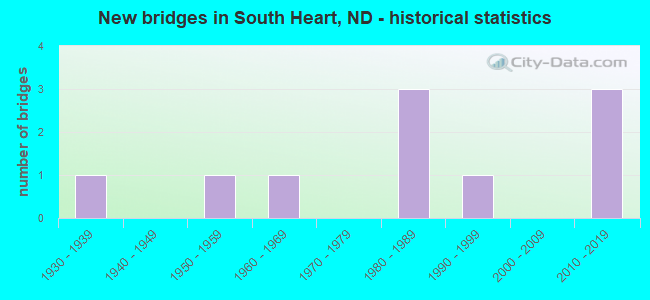
- New bridges - historical statistics
- 11930-1939
- 11950-1959
- 11960-1969
- 31980-1989
- 11990-1999
- 32010-2019


- Bridge Condition - Deck
- 20.0%Very good
- 60.0%Good
- 20.0%Satisfactory

- Bridge Condition - Superstructure
- 60.0%Very good
- 20.0%Good
- 20.0%Fair

- Bridge Condition - Substructure
- 60.0%Very good
- 20.0%Good
- 20.0%Fair

- Bridge Condition - Channel
- 42.9%Very good
- 14.3%Good
- 28.6%Satisfactory
- 14.3%Fair

- Bridge Condition - Culverts
- 66.7%Good
- 33.3%Fair
Find on map >> Show street view
Structure Number: 451101, Location: 1 WEST OF SOUTH HEART (Lat: 46.865269, Lng: -103.020308), Route carried "on" structure: County highway , Year Built: 1996, Status: Open, Structure Length: 2.41m (7.91ft), Average Daily Traffic: 24 (year 2018), Average Future Daily Traffic: 24 (year 2038), Design Load: HS 25 or greater, Features Intersected: HEART RIVER, Facility Carried by Structure: COUNTY HIGHWAY
Minimum Vertical Clearance: 30+ m (98+ ft), Kilometerpoint: 0.000, Lanes on structure: 2, Owner: County Highway Agency, Approaching Roadway Width: 7.3m (24.0ft), Skew: 1 degrees, Material/Design: Prestressed concrete continuous, Design/Construction: Box Beam or Girders - Single/Spread, Number Of Spans In Main Unit: 1, Length of Maximum Span: 23.8m (78.1ft), Curb-To-Curb Width: 8.7m (28.5ft), Out-to-Out Width: 9.4m (30.8ft)
Condition: Deck: Good, Superstructure: Very good, Substructure: Very good, Channel: Very good, Operating Rating: 62.3 metric tons, Method Used To Determine Operating Rating: Load Factor (LF), Inventory Rating: 25.8 metric tons, Method Used To Determine Inventory Rating: Load Factor (LF), Structural Evaluation: Equal to present minimum criteria, Deck Geometry: Better than present minimum criteria, Waterway Adequacy: Superior to present desirable criteria, Approach Roadway Alignment: Equal to present desirable criteria, Designated Inspection Frequency: Every 24 months, Inspection Date: August 2020, Deck Structure Type: Concrete Cast-file-Place, Wearing Surface/Protective System: Wearing Surface: Monolithic Concrete
Find on map >> Show street view
Structure Number: 4511012, Location: 1 W 1 S SOUTH HEART (Lat: 46.840078, Lng: -103.020083), Route carried "on" structure: County highway , Year Built: 1985, Status: Open, Structure Length: 2.80m (9.19ft), Average Daily Traffic: 40 (year 2018), Average Future Daily Traffic: 40 (year 2038), Design Load: HS 20, Features Intersected: SOUTH BRANCH HEART RIVER, Facility Carried by Structure: COUNTY HIGHWAY
Minimum Vertical Clearance: 30+ m (98+ ft), Kilometerpoint: 0.000, Lanes on structure: 2, Owner: County Highway Agency, Approaching Roadway Width: 7.3m (24.0ft), Material/Design: Prestressed concrete continuous, Design/Construction: Box Beam or Girders - Single/Spread, Number Of Spans In Main Unit: 3, Length of Maximum Span: 10.1m (33.1ft), Curb-To-Curb Width: 8.5m (27.9ft), Out-to-Out Width: 10.1m (33.1ft)
Condition: Deck: Very good, Superstructure: Very good, Substructure: Very good, Channel: Satisfactory, Operating Rating: 47.0 metric tons, Method Used To Determine Operating Rating: Load Factor (LF), Inventory Rating: 24.1 metric tons, Method Used To Determine Inventory Rating: Load Factor (LF), Structural Evaluation: Equal to present minimum criteria, Deck Geometry: Better than present minimum criteria, Waterway Adequacy: Equal to present desirable criteria, Approach Roadway Alignment: Equal to present desirable criteria, Designated Inspection Frequency: Every 24 months, Inspection Date: August 2020, Deck Structure Type: Concrete Cast-file-Place, Wearing Surface/Protective System: Wearing Surface: Monolithic Concrete
Find on map >> Show street view
Structure Number: 4511108, Location: 2 NORTH OF SOUTH HEART (Lat: 46.894503, Lng: -102.999075), Route carried "on" structure: County highway 4511, Year Built: 1988, Status: Open, Structure Length: 0.82m (2.69ft), Average Daily Traffic: 175 (year 2016), Truck Traffic: 10%, Average Future Daily Traffic: 300 (year 2036), Design Load: HS 20, Features Intersected: NORTH CREEK, Facility Carried by Structure: COUNTY HIGHWAY
Minimum Vertical Clearance: 30+ m (98+ ft), Kilometerpoint: 31.376, Lanes on structure: 2, Owner: County Highway Agency, Approaching Roadway Width: 8.5m (27.9ft), Material/Design: Concrete, Design/Construction: Culvert, Number Of Spans In Main Unit: 2, Length of Maximum Span: 4.0m (13.1ft)
Condition: Channel: Very good, Culverts: Good, Operating Rating: 54.0 metric tons, Method Used To Determine Operating Rating: Load Factor (LF), Inventory Rating: 32.4 metric tons, Method Used To Determine Inventory Rating: Load Factor (LF), Structural Evaluation: Better than present minimum criteria, Waterway Adequacy: Equal to present desirable criteria, Approach Roadway Alignment: Equal to present desirable criteria, Designated Inspection Frequency: Every 48 months, Inspection Date: August 2020
Find on map >> Show street view
Structure Number: 45111102, Location: 1 SW SOUTH HEART (Lat: 46.861875, Lng: -103.001869), Route carried "on" structure: County highway , Year Built: 1939, Status: Posted for load, Structure Length: 0.91m (2.99ft), Average Daily Traffic: 160 (year 2018), Truck Traffic: 12%, Average Future Daily Traffic: 160 (year 2038), Features Intersected: HEART RIVER, Facility Carried by Structure: 38TH ST SW
Minimum Vertical Clearance: 30+ m (98+ ft), Kilometerpoint: 0.000, Lanes on structure: 2, Owner: County Highway Agency, Approaching Roadway Width: 4.9m (16.1ft), Material/Design: Steel, Design/Construction: Stringer/Multi-beam, Number Of Spans In Main Unit: 1, Length of Maximum Span: 8.5m (27.9ft), Curb-To-Curb Width: 6.3m (20.7ft), Out-to-Out Width: 6.3m (20.7ft)
Condition: Deck: Satisfactory, Superstructure: Fair, Substructure: Fair, Channel: Fair, Operating Rating: 17.1 metric tons, Method Used To Determine Operating Rating: Load Factor (LF), Inventory Rating: 10.3 metric tons, Method Used To Determine Inventory Rating: Load Factor (LF), Structural Evaluation: High priority of replacement, Deck Geometry: Meets minimum limits, Waterway Adequacy: Meets minimum limits, Approach Roadway Alignment: High priority of corrective action, Bridge Posting: Required (Relationship of Operating Rating to Maximum Legal Load: > 39.9% below), Length Of Structure Improvement: 2.93m (9.61ft), Designated Inspection Frequency: Every 24 months, Inspection Date: August 2021, Bridge Improvement Cost: $132,000, Roadway Improvement Cost: $13,000, Total Project Cost: $198,000, Deck Structure Type: Wood or Timber, Wearing Surface/Protective System: Wearing Surface: Wood or Timber
Find on map >> Show street view
Structure Number: 451121, Location: NORTH OF SOUTH HEART (Lat: 46.869033, Lng: -102.995297), Route carried "on" structure: County highway 4511, Year Built: 1986, Status: Open, Structure Length: 3.11m (10.20ft), Average Daily Traffic: 710 (year 2018), Truck Traffic: 10%, Average Future Daily Traffic: 1,000 (year 2038), Design Load: HS 20, Features Intersected: HEART RIVER, Facility Carried by Structure: COUNTY HIGHWAY
Minimum Vertical Clearance: 30+ m (98+ ft), Kilometerpoint: 28.318, Lanes on structure: 2, Owner: County Highway Agency, Approaching Roadway Width: 8.5m (27.9ft), Material/Design: Prestressed concrete continuous, Design/Construction: Box Beam or Girders - Single/Spread, Number Of Spans In Main Unit: 3, Length of Maximum Span: 11.6m (38.1ft), Curb-To-Curb Width: 9.1m (29.9ft), Out-to-Out Width: 10.7m (35.1ft)
Condition: Deck: Good, Superstructure: Very good, Substructure: Very good, Channel: Very good, Operating Rating: 89.8 metric tons, Method Used To Determine Operating Rating: Load Factor (LF), Inventory Rating: 59.4 metric tons, Method Used To Determine Inventory Rating: Load Factor (LF), Structural Evaluation: Equal to present desirable criteria, Deck Geometry: Equal to present minimum criteria, Waterway Adequacy: Equal to present desirable criteria, Approach Roadway Alignment: Equal to present desirable criteria, Designated Inspection Frequency: Every 24 months, Inspection Date: August 2020, Deck Structure Type: Concrete Cast-file-Place, Wearing Surface/Protective System: Wearing Surface: Monolithic Concrete
Find on map >> Show street view
Structure Number: 4511309, Location: 1 S 1 E SOUTH HEART (Lat: 46.876489, Lng: -102.968361), Route carried "on" structure: County highway 4510, Year Built: 1953, Status: Open, Structure Length: 0.94m (3.08ft), Average Daily Traffic: 865 (year 2016), Truck Traffic: 10%, Average Future Daily Traffic: 1,100 (year 2036), Design Load: H 15, Features Intersected: CREEK, Facility Carried by Structure: COUNTY HIGHWAY
Minimum Vertical Clearance: 30+ m (98+ ft), Kilometerpoint: 20.434, Lanes on structure: 2, Owner: County Highway Agency, Approaching Roadway Width: 11.6m (38.1ft), Material/Design: Concrete, Design/Construction: Culvert, Number Of Spans In Main Unit: 3, Length of Maximum Span: 3.0m (9.8ft)
Condition: Channel: Satisfactory, Culverts: Fair, Operating Rating: 40.5 metric tons, Method Used To Determine Operating Rating: Load Factor (LF), Inventory Rating: 24.3 metric tons, Method Used To Determine Inventory Rating: Load Factor (LF), Structural Evaluation: Somewhat better than minimum adequacy, Waterway Adequacy: Better than present minimum criteria, Approach Roadway Alignment: Better than present minimum criteria, Designated Inspection Frequency: Every 24 months, Inspection Date: August 2020
Find on map >> Show street view
Structure Number: 94051476, Location: 9 EAST OF JCT. ND 85 (Lat: 46.888333, Lng: -102.998333), Route carried "on" structure: County highway 4511, Year Built: 2016, Status: Open, Structure Length: 8.17m (26.80ft), Average Daily Traffic: 510 (year 2019), Truck Traffic: 12%, Average Future Daily Traffic: 510 (year 2039), Design Load: HL 93, Features Intersected: I-94/SOUTH HEART INT, Facility Carried by Structure: COUNTY ROAD
Minimum Vertical Clearance: 30+ m (98+ ft), Kilometerpoint: 33.789, Lanes on structure: 2, Lanes under structure: 4, Owner: State Highway Agency, Approaching Roadway Width: 7.9m (25.9ft), Skew: 1 degrees, Material/Design: Prestressed concrete, Design/Construction: Stringer/Multi-beam, Number Of Spans In Main Unit: 2, Length of Maximum Span: 40.8m (133.9ft), Curb or Sidewalk Widths: Left: 0.4m (1.3ft), Right: 0.4m (1.3ft), Curb-To-Curb Width: 12.2m (40.0ft), Out-to-Out Width: 13.1m (43.0ft)
Condition: Deck: Good, Superstructure: Good, Substructure: Good, Operating Rating: 32.3 metric tons, Method Used To Determine Operating Rating: Load and Resistance Factor (LRFR), Inventory Rating: 24.9 metric tons, Method Used To Determine Inventory Rating: Load and Resistance Factor (LRFR), Structural Evaluation: Equal to present minimum criteria, Deck Geometry: Equal to present desirable criteria, Underclear: Equal to present minimum criteria, Approach Roadway Alignment: Meets minimum limits, Length Of Structure Improvement: 7.01m (23.00ft), Designated Inspection Frequency: Every 24 months, Inspection Date: May 2021, Bridge Improvement Cost: $390,000, Roadway Improvement Cost: $39,000, Total Project Cost: $585,000, Deck Structure Type: Concrete Cast-file-Place, Wearing Surface/Protective System: Wearing Surface: Low Slump Concrete
Find on map >> Show street view
Structure Number: 94052065, Location: 10 EAST OF JCT. US 85 (Lat: 46.889106, Lng: -102.986767), Route carried "on" structure: Interstate 94, Year Built: 1964, Status: Open, Structure Length: 1.13m (3.71ft), Average Daily Traffic: 5,000 (year 2019), Truck Traffic: 21%, Average Future Daily Traffic: 5,000 (year 2039), Design Load: HS 20, Features Intersected: NORTH CREEK
Minimum Vertical Clearance: 30+ m (98+ ft), Kilometerpoint: 83.773, Lanes on structure: 4, Base Highway Network: Yes, Owner: State Highway Agency, Approaching Roadway Width: 22.6m (74.1ft), Skew: 10 degrees, Material/Design: Concrete, Design/Construction: Culvert, Number Of Spans In Main Unit: 3, Length of Maximum Span: 3.7m (12.1ft)
Condition: Channel: Good, Culverts: Good, Operating Rating: 54.0 metric tons, Method Used To Determine Operating Rating: Load Factor (LF), Inventory Rating: 32.4 metric tons, Method Used To Determine Inventory Rating: Load Factor (LF), Structural Evaluation: Better than present minimum criteria, Waterway Adequacy: Equal to present desirable criteria, Approach Roadway Alignment: Equal to present desirable criteria, Designated Inspection Frequency: Every 48 months, Inspection Date: November 2019
Find on map >> Show street view
Structure Number: 94051476, Location: 9 EAST OF JCT. ND 85 (Lat: 46.888333, Lng: -102.998333), Route carried "under" structure: Interstate 94, Year Built: 2016, Structure Length: 0. m, Average Daily Traffic: 5,000 (year 2011), Truck Traffic: 21%, Features Intersected: I-94/SOUTH HEART INT, Facility Carried by Structure: COUNTY ROAD
Minimum Vertical Clearance: 5.14m (16.86ft), Kilometerpoint: 82.843, Lanes on structure: 2, Lanes under structure: 2, Material/Design: Prestressed concrete, Design/Construction: Stringer/Multi-beam, Length of Maximum Span: 40.8m (133.9ft)
Find on map >> Show street view
Structure Number: 94051476, Location: 9 EAST OF JCT. ND 85 (Lat: 46.888333, Lng: -102.998333), Route carried "under" structure: Interstate 94, Year Built: 2016, Structure Length: 0. m, Average Daily Traffic: 5,000 (year 2011), Truck Traffic: 21%, Features Intersected: I-94/SOUTH HEART INT, Facility Carried by Structure: COUNTY ROAD
Minimum Vertical Clearance: 5.18m (16.99ft), Kilometerpoint: 82.843, Lanes on structure: 2, Lanes under structure: 2, Material/Design: Prestressed concrete, Design/Construction: Stringer/Multi-beam, Length of Maximum Span: 40.8m (133.9ft)