Bridge Statistics for South Hutchinson, Kansas (KS)
Condition, Traffic, Stress, Structural Evaluation, Project Costs
- National Bridge Inventory (NBI) Statistics
- 37Number of bridges
- 502ft / 153mTotal length
- $345,000Total costs
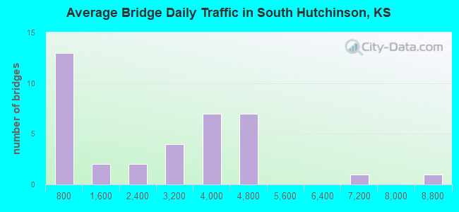
- 93,774Total average daily traffic
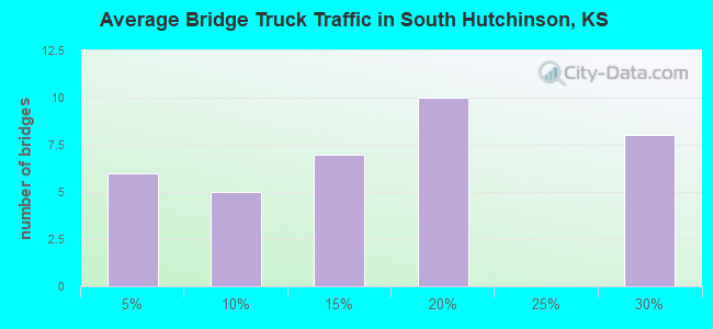
- 16,807Total average daily truck traffic
- National Bridge Inventory (NBI) Registered Bridges for South Hutchinson
- No street view available for this location

- New bridges - historical statistics
- 11920-1929
- 11930-1939
- 41950-1959
- 51960-1969
- 71970-1979
- 21980-1989
- 11990-1999
- 142000-2009
- 22010-2019
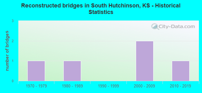
- Reconstructed bridges - Historical Statistics
- 11970-1979
- 11980-1989
- 01990-1999
- 22000-2009
- 12010-2019
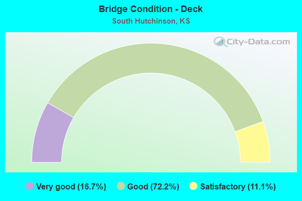
- Bridge Condition - Deck
- 16.7%Very good
- 72.2%Good
- 11.1%Satisfactory
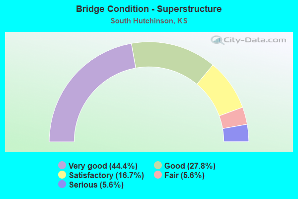
- Bridge Condition - Superstructure
- 44.4%Very good
- 27.8%Good
- 16.7%Satisfactory
- 5.6%Fair
- 5.6%Serious
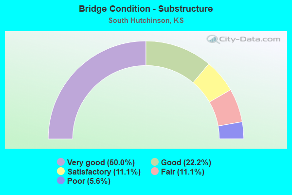
- Bridge Condition - Substructure
- 50.0%Very good
- 22.2%Good
- 11.1%Satisfactory
- 11.1%Fair
- 5.6%Poor
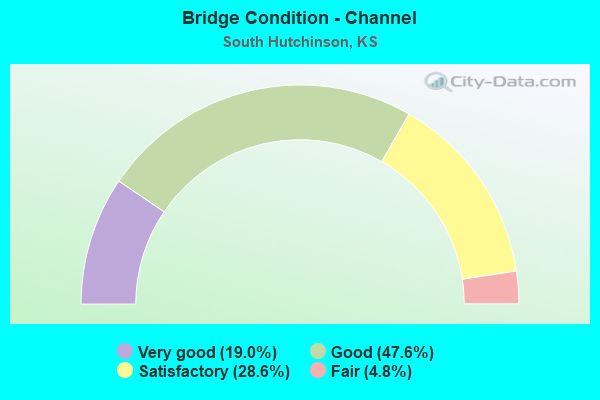
- Bridge Condition - Channel
- 19.0%Very good
- 47.6%Good
- 28.6%Satisfactory
- 4.8%Fair
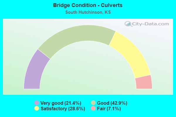
- Bridge Condition - Culverts
- 21.4%Very good
- 42.9%Good
- 28.6%Satisfactory
- 7.1%Fair
Find on map >> Show street view
Structure Number: 7803, Location: 0.5W OF ELMER (Lat: 37.969897, Lng: -97.941258), Route carried "on" structure: County highway 555, Year Built: 1962, Status: Open, Structure Length: 1.86m (6.10ft), Average Daily Traffic: 375 (year 2018), Truck Traffic: 10%, Average Future Daily Traffic: 450 (year 2040), Design Load: H 20, Features Intersected: SAND CREEK, Facility Carried by Structure: TRAIL WEST.29.95
Minimum Vertical Clearance: 30.47m (99.97ft), Kilometerpoint: 0.000, Lanes on structure: 2, Owner: County Highway Agency, Approaching Roadway Width: 7.3m (24.0ft), Skew: 4 degrees, Material/Design: Concrete, Design/Construction: Culvert, Number Of Spans In Main Unit: 4, Length of Maximum Span: 4.3m (14.1ft), Curb-To-Curb Width: 9.3m (30.5ft), Out-to-Out Width: 9.9m (32.5ft)
Condition: Channel: Satisfactory, Culverts: Satisfactory, Operating Rating: 38.7 metric tons, Method Used To Determine Operating Rating: Load Factor (LF), Inventory Rating: 25.2 metric tons, Method Used To Determine Inventory Rating: Load Factor (LF), Structural Evaluation: Equal to present minimum criteria, Deck Geometry: Equal to present minimum criteria, Waterway Adequacy: Better than present minimum criteria, Approach Roadway Alignment: Equal to present desirable criteria, Designated Inspection Frequency: Every 24 months, Inspection Date: July 2020, Wearing Surface/Protective System: Wearing Surface: Bituminous
Find on map >> Show street view
Structure Number: 78074, Location: 0.5S OF WHITESIDE (Lat: 37.998194, Lng: -98.013903), Route carried "on" structure: County highway 561, Year Built: 1951, Status: Open, Structure Length: 1.28m (4.20ft), Average Daily Traffic: 555 (year 2018), Truck Traffic: 10%, Average Future Daily Traffic: 560 (year 2040), Design Load: H 15, Features Intersected: STREAM
Minimum Vertical Clearance: 30.47m (99.97ft), Kilometerpoint: 0.000, Lanes on structure: 2, Owner: County Highway Agency, Approaching Roadway Width: 6.7m (22.0ft), Material/Design: Concrete, Design/Construction: Culvert, Number Of Spans In Main Unit: 5, Length of Maximum Span: 2.4m (7.9ft), Curb-To-Curb Width: 7.9m (25.9ft), Out-to-Out Width: 8.5m (27.9ft)
Condition: Channel: Good, Culverts: Good, Operating Rating: 27.0 metric tons, Method Used To Determine Operating Rating: Load Factor (LF), Inventory Rating: 17.1 metric tons, Method Used To Determine Inventory Rating: Load Factor (LF), Structural Evaluation: Meets minimum limits, Deck Geometry: Somewhat better than minimum adequacy, Waterway Adequacy: Equal to present minimum criteria, Approach Roadway Alignment: Equal to present desirable criteria, Designated Inspection Frequency: Every 24 months, Inspection Date: June 2020, Wearing Surface/Protective System: Wearing Surface: Bituminous
Find on map >> Show street view
Structure Number: 780745905761, Location: 2.1N 4.2E OF PARTRIDGE (Lat: 37.999183, Lng: -98.014308), Route carried "on" structure: County highway , Year Built: 1959, Status: Posted for load, Structure Length: 1.15m (3.77ft), Average Daily Traffic: 129 (year 2006), Truck Traffic: 10%, Average Future Daily Traffic: 155 (year 2040), Design Load: H 15, Features Intersected: DRAIN, Facility Carried by Structure: MORGAN AVE.25.99
Minimum Vertical Clearance: 30.47m (99.97ft), Kilometerpoint: 0.000, Lanes on structure: 2, Owner: County Highway Agency, Approaching Roadway Width: 6.0m (19.7ft), Material/Design: Concrete continuous, Design/Construction: Slab, Number Of Spans In Main Unit: 2, Length of Maximum Span: 5.5m (18.0ft), Curb-To-Curb Width: 6.1m (20.0ft), Out-to-Out Width: 6.7m (22.0ft)
Condition: Deck: Satisfactory, Superstructure: Satisfactory, Substructure: Satisfactory, Channel: Fair, Operating Rating: 24.7 metric tons, Method Used To Determine Operating Rating: Load Factor (LF), Inventory Rating: 14.8 metric tons, Method Used To Determine Inventory Rating: Load Factor (LF), Structural Evaluation: Meets minimum limits, Deck Geometry: Meets minimum limits, Waterway Adequacy: Equal to present minimum criteria, Approach Roadway Alignment: Equal to present desirable criteria, Bridge Posting: Required (Relationship of Operating Rating to Maximum Legal Load: > 39.9% below), Designated Inspection Frequency: Every 24 months, Inspection Date: June 2020, Other Special Inspection Date: April 2021, Deck Structure Type: Concrete Cast-file-Place
Find on map >> Show street view
Structure Number: 780751005762, Location: 2.2W 3.5S OF HUTCHINSON (Lat: 37.995611, Lng: -97.976972), Route carried "on" structure: County highway , Year Built: 1956, Status: Open, Structure Length: 1.49m (4.89ft), Average Daily Traffic: 72 (year 2006), Truck Traffic: 7%, Average Future Daily Traffic: 85 (year 2040), Design Load: H 15, Features Intersected: DRAIN, Facility Carried by Structure: BROADACRES.18.75
Minimum Vertical Clearance: 30.47m (99.97ft), Kilometerpoint: 0.000, Lanes on structure: 2, Owner: County Highway Agency, Approaching Roadway Width: 6.7m (22.0ft), Skew: 3 degrees, Material/Design: Concrete, Design/Construction: Culvert, Number Of Spans In Main Unit: 4, Length of Maximum Span: 3.7m (12.1ft), Curb-To-Curb Width: 7.3m (24.0ft), Out-to-Out Width: 8.0m (26.2ft)
Condition: Channel: Satisfactory, Culverts: Satisfactory, Operating Rating: 28.8 metric tons, Method Used To Determine Operating Rating: Load Factor (LF), Inventory Rating: 17.1 metric tons, Method Used To Determine Inventory Rating: Load Factor (LF), Structural Evaluation: Somewhat better than minimum adequacy, Deck Geometry: Equal to present minimum criteria, Waterway Adequacy: Better than present minimum criteria, Approach Roadway Alignment: Equal to present desirable criteria, Designated Inspection Frequency: Every 24 months, Inspection Date: July 2020, Wearing Surface/Protective System: Wearing Surface: Gravel
Find on map >> Show street view
Structure Number: 78075130578, Location: 5.0S 2.4W OF HUTCHINSON (Lat: 37.984189, Lng: -97.973889), Route carried "on" structure: County highway 1383, Year Built: 2018, Status: Open, Structure Length: 1.40m (4.59ft), Average Daily Traffic: 30 (year 2018), Truck Traffic: 2%, Average Future Daily Traffic: 36 (year 2040), Design Load: HS 20, Features Intersected: SAND CREEK, Facility Carried by Structure: MILLS AVE.28.20
Minimum Vertical Clearance: 30.47m (99.97ft), Kilometerpoint: 0.000, Lanes on structure: 2, Owner: County Highway Agency, Approaching Roadway Width: 8.5m (27.9ft), Material/Design: Concrete, Design/Construction: Box Beam or Girders - Multiple, Number Of Spans In Main Unit: 1, Length of Maximum Span: 13.6m (44.6ft), Curb-To-Curb Width: 8.4m (27.6ft), Out-to-Out Width: 8.6m (28.2ft)
Condition: Deck: Very good, Superstructure: Very good, Substructure: Very good, Channel: Good, Operating Rating: 60.1 metric tons, Method Used To Determine Operating Rating: Load Factor (LF), Inventory Rating: 35.9 metric tons, Method Used To Determine Inventory Rating: Load Factor (LF), Structural Evaluation: Equal to present desirable criteria, Deck Geometry: Equal to present minimum criteria, Waterway Adequacy: Better than present minimum criteria, Approach Roadway Alignment: Equal to present desirable criteria, Designated Inspection Frequency: Every 24 months, Inspection Date: July 2020, Wearing Surface/Protective System: Wearing Surface: Monolithic Concrete
Find on map >> Show street view
Structure Number: 780753005729, Location: S.W. EDGE OF S HUTCHINSON (Lat: 38.015000, Lng: -97.958444), Route carried "on" structure: County highway , Year Built: 1982, Status: Open, Structure Length: 1.55m (5.09ft), Average Daily Traffic: 73 (year 2006), Truck Traffic: 5%, Average Future Daily Traffic: 85 (year 2040), Features Intersected: DRAIN, Facility Carried by Structure: Valley Pride Rd
Minimum Vertical Clearance: 30.47m (99.97ft), Kilometerpoint: 0.000, Lanes on structure: 2, Owner: County Highway Agency, Approaching Roadway Width: 7.3m (24.0ft), Material/Design: Steel continuous, Design/Construction: Stringer/Multi-beam, Number Of Spans In Main Unit: 2, Length of Maximum Span: 7.5m (24.6ft), Curb-To-Curb Width: 8.4m (27.6ft), Out-to-Out Width: 8.7m (28.5ft)
Condition: Deck: Good, Superstructure: Satisfactory, Substructure: Satisfactory, Channel: Satisfactory, Operating Rating: 12.3 metric tons, Method Used To Determine Operating Rating: Load Factor (LF), Inventory Rating: 7.3 metric tons, Method Used To Determine Inventory Rating: Load Factor (LF), Structural Evaluation: High priority of corrective action, Deck Geometry: Equal to present minimum criteria, Waterway Adequacy: Equal to present minimum criteria, Approach Roadway Alignment: Equal to present desirable criteria, Bridge Posting: Required (Relationship of Operating Rating to Maximum Legal Load: > 39.9% below), Designated Inspection Frequency: Every 24 months, Inspection Date: July 2020, Other Special Inspection Date: March 2021, Deck Structure Type: Corrugated Steel, Wearing Surface/Protective System: Wearing Surface: Gravel
Find on map >> Show street view
Structure Number: 780753005787, Location: 2.5S OF S. HUTCHINSON (Lat: 37.975333, Lng: -97.959069), Route carried "on" structure: County highway , Year Built: 1955, Status: Open, Structure Length: 0.79m (2.59ft), Average Daily Traffic: 34 (year 2018), Truck Traffic: 5%, Average Future Daily Traffic: 40 (year 2040), Design Load: H 10, Features Intersected: DRAIN, Facility Carried by Structure: VALLEY PRIDE.17.30
Minimum Vertical Clearance: 30.47m (99.97ft), Kilometerpoint: 0.000, Lanes on structure: 2, Owner: County Highway Agency, Approaching Roadway Width: 6.0m (19.7ft), Material/Design: Concrete, Design/Construction: Channel Beam, Number Of Spans In Main Unit: 1, Length of Maximum Span: 7.3m (24.0ft), Curb-To-Curb Width: 6.5m (21.3ft), Out-to-Out Width: 6.9m (22.6ft)
Condition: Deck: Good, Superstructure: Satisfactory, Substructure: Poor, Channel: Satisfactory, Operating Rating: 30.6 metric tons, Method Used To Determine Operating Rating: Allowable Stress (AS), Inventory Rating: 23.4 metric tons, Method Used To Determine Inventory Rating: Allowable Stress (AS), Structural Evaluation: Meets minimum limits, Deck Geometry: Somewhat better than minimum adequacy, Waterway Adequacy: Equal to present minimum criteria, Approach Roadway Alignment: Equal to present desirable criteria, Length Of Structure Improvement: 0.91m (2.99ft), Designated Inspection Frequency: Every 24 months, Inspection Date: July 2020, Bridge Improvement Cost: $120,000, Roadway Improvement Cost: $15,000, Total Project Cost: $135,000 ( Estimate for 2018), Deck Structure Type: Concrete Cast-file-Place, Wearing Surface/Protective System: Wearing Surface: Gravel
Find on map >> Show street view
Structure Number: 78075720578, Location: 2.0S 0.5E OF HUTCHINSON (Lat: 37.984778, Lng: -97.917139), Route carried "on" structure: County highway , Year Built: 2010, Status: Open, Structure Length: 1.86m (6.10ft), Average Daily Traffic: 32 (year 2006), Truck Traffic: 5%, Average Future Daily Traffic: 40 (year 2040), Design Load: HS 20, Features Intersected: SAND CREEK, Facility Carried by Structure: MILLS AVENUE
Minimum Vertical Clearance: 30.47m (99.97ft), Kilometerpoint: 0.000, Lanes on structure: 2, Owner: County Highway Agency, Approaching Roadway Width: 6.0m (19.7ft), Material/Design: Steel, Design/Construction: Stringer/Multi-beam, Number Of Spans In Main Unit: 1, Length of Maximum Span: 18.3m (60.0ft), Curb-To-Curb Width: 8.5m (27.9ft), Out-to-Out Width: 8.7m (28.5ft)
Condition: Deck: Good, Superstructure: Good, Substructure: Good, Channel: Good, Operating Rating: 64.5 metric tons, Method Used To Determine Operating Rating: Allowable Stress (AS), Inventory Rating: 41.4 metric tons, Method Used To Determine Inventory Rating: Allowable Stress (AS), Structural Evaluation: Better than present minimum criteria, Deck Geometry: Better than present minimum criteria, Waterway Adequacy: Better than present minimum criteria, Approach Roadway Alignment: Equal to present desirable criteria, Designated Inspection Frequency: Every 24 months, Inspection Date: July 2020, Deck Structure Type: Concrete Cast-file-Place, Wearing Surface/Protective System: Wearing Surface: Monolithic Concrete
Find on map >> Show street view
Structure Number: 413500781809125, Location: SOUTH MAIN ST. & ARK. R. (Lat: 38.038333, Lng: -97.933333), Route carried "on" structure: County highway 1809, Year Built: 1961, Year Reconstructed: 1982, Status: Open, Structure Length: 30.75m (100.89ft), Average Daily Traffic: 6,858 (year 2005), Truck Traffic: 10%, Average Future Daily Traffic: 8,230 (year 2040), Design Load: HS 20, Features Intersected: ARKANSAS RIVER, Facility Carried by Structure: S. Main St.
Minimum Vertical Clearance: 30.47m (99.97ft), Kilometerpoint: 0.000, Lanes on structure: 2, Owner: County Highway Agency, Approaching Roadway Width: 14.9m (48.9ft), Skew: 1 degrees, Material/Design: Steel continuous, Design/Construction: Stringer/Multi-beam, Number Of Spans In Main Unit: 23, Length of Maximum Span: 13.7m (44.9ft), Curb or Sidewalk Widths: Left: 0.0m, Right: 1.7m (5.6ft), Curb-To-Curb Width: 12.2m (40.0ft), Out-to-Out Width: 15.0m (49.2ft)
Condition: Deck: Good, Superstructure: Fair, Substructure: Fair, Channel: Satisfactory, Operating Rating: 51.5 metric tons, Method Used To Determine Operating Rating: Load Factor (LF), Inventory Rating: 31.0 metric tons, Method Used To Determine Inventory Rating: Load Factor (LF), Structural Evaluation: Somewhat better than minimum adequacy, Deck Geometry: Somewhat better than minimum adequacy, Waterway Adequacy: Equal to present desirable criteria, Approach Roadway Alignment: Equal to present desirable criteria, Designated Inspection Frequency: Every 24 months, Other Special Inspection Frequency: Every 12 months, Inspection Date: July 2020, Other Special Inspection Date: May 2021, Deck Structure Type: Concrete Cast-file-Place, Wearing Surface/Protective System: Deck Protection: Epoxy Coated Reinforcing
Find on map >> Show street view
Structure Number: 426700781800002, Location: 500' NW of Andrew Ave. (Lat: 38.018333, Lng: -97.928333), Route carried "on" structure: City street C1800, Year Built: 1983, Status: Posted for load, Structure Length: 2.13m (6.99ft), Average Daily Traffic: 1,460 (year 2016), Truck Traffic: 10%, Average Future Daily Traffic: 1,699 (year 2043), Features Intersected: Drainage, Facility Carried by Structure: Scott Blvd.
Minimum Vertical Clearance: 30.47m (99.97ft), Kilometerpoint: 0.000, Lanes on structure: 2, Owner: City or Municipal Highway Agency, Approaching Roadway Width: 7.3m (24.0ft), Material/Design: Steel continuous, Design/Construction: Stringer/Multi-beam, Number Of Spans In Main Unit: 2, Length of Maximum Span: 10.7m (35.1ft), Curb-To-Curb Width: 8.4m (27.6ft), Out-to-Out Width: 8.6m (28.2ft)
Condition: Deck: Satisfactory, Superstructure: Serious, Substructure: Fair, Channel: Satisfactory, Operating Rating: 5.8 metric tons, Method Used To Determine Operating Rating: Load Factor (LF), Inventory Rating: 3.6 metric tons, Method Used To Determine Inventory Rating: Load Factor (LF), Structural Evaluation: High priority of corrective action, Deck Geometry: Meets minimum limits, Waterway Adequacy: Equal to present minimum criteria, Approach Roadway Alignment: Equal to present desirable criteria, Bridge Posting: Required (Relationship of Operating Rating to Maximum Legal Load: > 39.9% below), Designated Inspection Frequency: Every 12 months, Inspection Date: May 2021, Wearing Surface/Protective System: Wearing Surface: Bituminous
Find on map >> Show street view
Structure Number: 426700781841001, Location: Poplar at Wabash (Lat: 38.016667, Lng: -97.936667), Route carried "on" structure: City street C1841, Year Built: 1967, Year Reconstructed: 2015, Status: Open, Structure Length: 1.52m (4.99ft), Average Daily Traffic: 1,225 (year 2016), Truck Traffic: 2%, Average Future Daily Traffic: 500 (year 2043), Features Intersected: Trib. To Arkansas River, Facility Carried by Structure: Poplar St.
Minimum Vertical Clearance: 30.47m (99.97ft), Kilometerpoint: 0.000, Lanes on structure: 2, Owner: City or Municipal Highway Agency, Approaching Roadway Width: 12.1m (39.7ft), Material/Design: Concrete, Design/Construction: Culvert, Number Of Spans In Main Unit: 4, Length of Maximum Span: 3.7m (12.1ft), Curb or Sidewalk Widths: Left: 2.1m (6.9ft), Right: 2.0m (6.6ft), Curb-To-Curb Width: 12.3m (40.4ft), Out-to-Out Width: 16.5m (54.1ft)
Condition: Channel: Very good, Culverts: Good, Operating Rating: 31.0 metric tons, Method Used To Determine Operating Rating: Load Factor (LF), Inventory Rating: 18.6 metric tons, Method Used To Determine Inventory Rating: Load Factor (LF), Structural Evaluation: Somewhat better than minimum adequacy, Deck Geometry: Better than present minimum criteria, Waterway Adequacy: Equal to present minimum criteria, Approach Roadway Alignment: Equal to present desirable criteria, Length Of Structure Improvement: 2.23m (7.32ft), Designated Inspection Frequency: Every 24 months, Inspection Date: May 2021, Bridge Improvement Cost: $107,000, Roadway Improvement Cost: $100,000, Total Project Cost: $210,000
Find on map >> Show street view
Structure Number: 426700781850003, Location: 350' S. of Marshall Ave (Lat: 38.017111, Lng: -97.940139), Route carried "on" structure: City street , Year Built: 1967, Status: Open, Structure Length: 1.52m (4.99ft), Average Daily Traffic: 8,670 (year 2016), Truck Traffic: 2%, Average Future Daily Traffic: 5,540 (year 2043), Design Load: H 20, Features Intersected: Trib. To Arkansas River, Facility Carried by Structure: S. Main St.
Minimum Vertical Clearance: 30.47m (99.97ft), Kilometerpoint: 0.000, Lanes on structure: 5, Owner: City or Municipal Highway Agency, Approaching Roadway Width: 16.1m (52.8ft), Material/Design: Concrete, Design/Construction: Culvert, Number Of Spans In Main Unit: 4, Length of Maximum Span: 3.7m (12.1ft), Curb or Sidewalk Widths: Left: 3.8m (12.5ft), Right: 2.8m (9.2ft), Curb-To-Curb Width: 21.5m (70.5ft), Out-to-Out Width: 28.1m (92.2ft)
Condition: Channel: Good, Culverts: Fair, Operating Rating: 33.3 metric tons, Method Used To Determine Operating Rating: Load Factor (LF), Inventory Rating: 19.9 metric tons, Method Used To Determine Inventory Rating: Load Factor (LF), Structural Evaluation: Somewhat better than minimum adequacy, Deck Geometry: Somewhat better than minimum adequacy, Waterway Adequacy: Equal to present minimum criteria, Approach Roadway Alignment: Equal to present desirable criteria, Designated Inspection Frequency: Every 24 months, Inspection Date: May 2021
Find on map >> Show street view
Structure Number: 999900140781151, Location: 1.9 MI N OF K14/US50 JCT (Lat: 38.035278, Lng: -97.985556), Route carried "on" structure: County highway 1806, Year Built: 2002, Status: Open, Structure Length: 9.70m (31.82ft), Average Daily Traffic: 634 (year 2020), Truck Traffic: 5%, Average Future Daily Traffic: 647 (year 2041), Design Load: HS 20, Features Intersected: K-14 HWY, Facility Carried by Structure: SIXTH AVENUE
Minimum Vertical Clearance: 30.47m (99.97ft), Kilometerpoint: 0.145, Lanes on structure: 2, Lanes under structure: 2, Owner: State Highway Agency, Approaching Roadway Width: 12.2m (40.0ft), Material/Design: Prestressed concrete continuous, Design/Construction: Stringer/Multi-beam, Number Of Spans In Main Unit: 4, Length of Maximum Span: 27.1m (88.9ft), Curb-To-Curb Width: 12.2m (40.0ft), Out-to-Out Width: 12.8m (42.0ft)
Condition: Deck: Good, Superstructure: Very good, Substructure: Very good, Operating Rating: 65.7 metric tons, Method Used To Determine Operating Rating: Load Factor (LF), Inventory Rating: 33.5 metric tons, Method Used To Determine Inventory Rating: Load Factor (LF), Structural Evaluation: Equal to present desirable criteria, Deck Geometry: Equal to present desirable criteria, Underclear: Superior to present desirable criteria, Approach Roadway Alignment: Meets minimum limits, Length Of Structure Improvement: 31.82m (104.40ft), Designated Inspection Frequency: Every 24 months, Inspection Date: October 2020, Wearing Surface/Protective System: Wearing Surface: Monolithic Concrete, Deck Protection: Epoxy Coated Reinforcing
Find on map >> Show street view
Structure Number: 999901700780361, Location: 0.48 MI S K96 (Lat: 37.965833, Lng: -97.940278), Route carried "on" structure: State highway 14, Year Built: 1933, Status: Open, Structure Length: 0.78m (2.56ft), Average Daily Traffic: 2,226 (year 2020), Truck Traffic: 11%, Average Future Daily Traffic: 2,716 (year 2041), Design Load: H 15, Features Intersected: SAND CREEK DRAINAGE
Minimum Vertical Clearance: 30.47m (99.97ft), Kilometerpoint: 25.836, Lanes on structure: 2, Base Highway Network: Yes, Owner: State Highway Agency, Approaching Roadway Width: 7.3m (24.0ft), Material/Design: Concrete, Design/Construction: Culvert, Number Of Spans In Main Unit: 3, Length of Maximum Span: 2.4m (7.9ft), Curb-To-Curb Width: 9.8m (32.2ft), Out-to-Out Width: 10.5m (34.4ft)
Condition: Channel: Good, Culverts: Satisfactory, Operating Rating: 33.8 metric tons, Method Used To Determine Operating Rating: Load Factor (LF), Inventory Rating: 20.3 metric tons, Method Used To Determine Inventory Rating: Load Factor (LF), Structural Evaluation: Somewhat better than minimum adequacy, Deck Geometry: Meets minimum limits, Waterway Adequacy: Equal to present minimum criteria, Approach Roadway Alignment: Better than present minimum criteria, Length Of Structure Improvement: 2.55m (8.37ft), Designated Inspection Frequency: Every 24 months, Inspection Date: October 2020, Deck Structure Type: Concrete Cast-file-Place, Wearing Surface/Protective System: Wearing Surface: Bituminous
Find on map >> Show street view
Structure Number: 999901700780371, Location: 0.23 MI S K96 (Lat: 37.969444, Lng: -97.940278), Route carried "on" structure: State highway 14, Year Built: 1927, Year Reconstructed: 1987, Status: Open, Structure Length: 1.96m (6.43ft), Average Daily Traffic: 2,226 (year 2020), Truck Traffic: 11%, Average Future Daily Traffic: 2,716 (year 2041), Design Load: H 15, Features Intersected: SAND CREEK
Minimum Vertical Clearance: 30.47m (99.97ft), Kilometerpoint: 26.237, Lanes on structure: 2, Base Highway Network: Yes, Owner: State Highway Agency, Approaching Roadway Width: 7.3m (24.0ft), Material/Design: Concrete, Design/Construction: Culvert, Number Of Spans In Main Unit: 6, Length of Maximum Span: 3.0m (9.8ft), Curb-To-Curb Width: 12.2m (40.0ft), Out-to-Out Width: 15.1m (49.5ft)
Condition: Channel: Good, Culverts: Good, Operating Rating: 33.2 metric tons, Method Used To Determine Operating Rating: Load Factor (LF), Inventory Rating: 19.9 metric tons, Method Used To Determine Inventory Rating: Load Factor (LF), Structural Evaluation: Somewhat better than minimum adequacy, Deck Geometry: Equal to present minimum criteria, Waterway Adequacy: Meets minimum limits, Approach Roadway Alignment: Somewhat better than minimum adequacy, Length Of Structure Improvement: 6.44m (21.13ft), Designated Inspection Frequency: Every 24 months, Inspection Date: October 2020, Deck Structure Type: Concrete Cast-file-Place, Wearing Surface/Protective System: Wearing Surface: Bituminous
Find on map >> Show street view
Structure Number: 999905000780101, Location: 4.96 MI NE WJCT K61 (Lat: 38.013333, Lng: -97.959722), Route carried "on" structure: US 50, Year Built: 1970, Status: Open, Structure Length: 1.88m (6.17ft), Average Daily Traffic: 4,181 (year 2020), Truck Traffic: 29%, Average Future Daily Traffic: 5,974 (year 2041), Design Load: HS 20, Features Intersected: ARKANSAS RIVER DRAINAGE
Minimum Vertical Clearance: 30.47m (99.97ft), Kilometerpoint: 47.426, Lanes on structure: 4, Base Highway Network: Yes, Owner: State Highway Agency, Approaching Roadway Width: 24.4m (80.1ft), Skew: 20 degrees, Material/Design: Concrete, Design/Construction: Culvert, Number Of Spans In Main Unit: 3, Length of Maximum Span: 6.1m (20.0ft), Curb-To-Curb Width: 24.4m (80.1ft), Out-to-Out Width: 46.3m (151.9ft)
Condition: Channel: Good, Culverts: Satisfactory, Operating Rating: 58.1 metric tons, Method Used To Determine Operating Rating: Load Factor (LF), Inventory Rating: 34.5 metric tons, Method Used To Determine Inventory Rating: Load Factor (LF), Structural Evaluation: Equal to present minimum criteria, Deck Geometry: Superior to present desirable criteria, Waterway Adequacy: Better than present minimum criteria, Approach Roadway Alignment: Equal to present desirable criteria, Length Of Structure Improvement: 6.18m (20.28ft), Designated Inspection Frequency: Every 24 months, Inspection Date: October 2020, Deck Structure Type: Concrete Cast-file-Place, Wearing Surface/Protective System: Wearing Surface: Bituminous
Find on map >> Show street view
Structure Number: 999905000780111, Location: 5.86 MI NE WJCT K61 (Lat: 38.013056, Lng: -97.943056), Route carried "on" structure: US 50, Year Built: 1970, Year Reconstructed: 2007, Status: Open, Structure Length: 0.76m (2.49ft), Average Daily Traffic: 4,181 (year 2020), Truck Traffic: 29%, Average Future Daily Traffic: 5,974 (year 2041), Design Load: HS 20, Features Intersected: ARKANSAS RIVER DRAINAGE
Minimum Vertical Clearance: 30.47m (99.97ft), Kilometerpoint: 48.873, Lanes on structure: 6, Base Highway Network: Yes, Owner: State Highway Agency, Approaching Roadway Width: 24.4m (80.1ft), Skew: 20 degrees, Material/Design: Concrete, Design/Construction: Culvert, Number Of Spans In Main Unit: 3, Length of Maximum Span: 2.4m (7.9ft), Curb-To-Curb Width: 32.9m (107.9ft), Out-to-Out Width: 52.9m (173.6ft)
Condition: Channel: Very good, Culverts: Good, Operating Rating: 42.7 metric tons, Method Used To Determine Operating Rating: Load Factor (LF), Inventory Rating: 25.6 metric tons, Method Used To Determine Inventory Rating: Load Factor (LF), Structural Evaluation: Equal to present minimum criteria, Deck Geometry: Superior to present desirable criteria, Waterway Adequacy: Better than present minimum criteria, Approach Roadway Alignment: Equal to present desirable criteria, Length Of Structure Improvement: 2.50m (8.20ft), Designated Inspection Frequency: Every 24 months, Inspection Date: October 2020, Deck Structure Type: Concrete Cast-file-Place, Wearing Surface/Protective System: Wearing Surface: Monolithic Concrete
Find on map >> Show street view
Structure Number: 999905000780121, Location: JCT K14/US50 (Lat: 38.013056, Lng: -97.940000), Route carried "on" structure: US 50, Year Built: 1970, Status: Open, Structure Length: 5.20m (17.06ft), Average Daily Traffic: 3,737 (year 2020), Truck Traffic: 18%, Average Future Daily Traffic: 5,339 (year 2041), Design Load: HS 20, Features Intersected: K14 HIGHWAY
Minimum Vertical Clearance: 30.47m (99.97ft), Kilometerpoint: 49.156, Lanes on structure: 2, Lanes under structure: 6, Base Highway Network: Yes, Owner: State Highway Agency, Approaching Roadway Width: 12.2m (40.0ft), Material/Design: Concrete continuous, Design/Construction: Slab, Number Of Spans In Main Unit: 4, Length of Maximum Span: 14.6m (47.9ft), Curb-To-Curb Width: 12.2m (40.0ft), Out-to-Out Width: 12.8m (42.0ft)
Condition: Deck: Good, Superstructure: Good, Substructure: Good, Operating Rating: 90.6 metric tons, Method Used To Determine Operating Rating: Load Factor (LF), Inventory Rating: 58.1 metric tons, Method Used To Determine Inventory Rating: Load Factor (LF), Structural Evaluation: Better than present minimum criteria, Deck Geometry: Better than present minimum criteria, Underclear: High priority of corrective action, Approach Roadway Alignment: Equal to present desirable criteria, Length Of Structure Improvement: 17.05m (55.94ft), Designated Inspection Frequency: Every 24 months, Inspection Date: October 2020, Deck Structure Type: Concrete Cast-file-Place, Wearing Surface/Protective System: Wearing Surface: Low Slump Concrete
Find on map >> Show street view
Structure Number: 999905000780131, Location: JCT K14/US50 (Lat: 38.013056, Lng: -97.940000), Route carried "on" structure: US 50, Year Built: 1970, Status: Open, Structure Length: 5.20m (17.06ft), Average Daily Traffic: 3,737 (year 2020), Truck Traffic: 18%, Average Future Daily Traffic: 5,339 (year 2041), Design Load: HS 20, Features Intersected: K14 HIGHWAY
Minimum Vertical Clearance: 30.47m (99.97ft), Kilometerpoint: 49.125, Lanes on structure: 2, Lanes under structure: 6, Base Highway Network: Yes, Owner: State Highway Agency, Approaching Roadway Width: 12.2m (40.0ft), Material/Design: Concrete continuous, Design/Construction: Slab, Number Of Spans In Main Unit: 4, Length of Maximum Span: 14.6m (47.9ft), Curb-To-Curb Width: 12.2m (40.0ft), Out-to-Out Width: 12.8m (42.0ft)
Condition: Deck: Good, Superstructure: Good, Substructure: Very good, Operating Rating: 90.6 metric tons, Method Used To Determine Operating Rating: Load Factor (LF), Inventory Rating: 58.1 metric tons, Method Used To Determine Inventory Rating: Load Factor (LF), Structural Evaluation: Better than present minimum criteria, Deck Geometry: Better than present minimum criteria, Underclear: High priority of corrective action, Approach Roadway Alignment: Equal to present desirable criteria, Length Of Structure Improvement: 17.05m (55.94ft), Designated Inspection Frequency: Every 24 months, Inspection Date: October 2020, Deck Structure Type: Concrete Cast-file-Place, Wearing Surface/Protective System: Wearing Surface: Low Slump Concrete
Find on map >> Show street view
Structure Number: 999905000780141, Location: 0.53 MI E OF K-96 HIGHWAY (Lat: 38.013056, Lng: -97.930556), Route carried "on" structure: US 50, Year Built: 1964, Status: Open, Structure Length: 3.43m (11.25ft), Average Daily Traffic: 3,737 (year 2020), Truck Traffic: 18%, Average Future Daily Traffic: 5,339 (year 2041), Design Load: HS 20, Features Intersected: K&O RAILROAD
Minimum Vertical Clearance: 30.47m (99.97ft), Kilometerpoint: 49.981, Lanes on structure: 2, Base Highway Network: Yes, Owner: State Highway Agency, Approaching Roadway Width: 13.4m (44.0ft), Material/Design: Concrete continuous, Design/Construction: Slab, Number Of Spans In Main Unit: 3, Length of Maximum Span: 13.4m (44.0ft), Curb-To-Curb Width: 12.2m (40.0ft), Out-to-Out Width: 12.8m (42.0ft)
Condition: Deck: Good, Superstructure: Good, Substructure: Good, Operating Rating: 49.9 metric tons, Method Used To Determine Operating Rating: Load Factor (LF), Inventory Rating: 29.9 metric tons, Method Used To Determine Inventory Rating: Load Factor (LF), Structural Evaluation: Better than present minimum criteria, Deck Geometry: Equal to present minimum criteria, Underclear: Superior to present desirable criteria, Approach Roadway Alignment: Somewhat better than minimum adequacy, Length Of Structure Improvement: 11.25m (36.91ft), Designated Inspection Frequency: Every 24 months, Inspection Date: October 2020, Deck Structure Type: Concrete Cast-file-Place, Wearing Surface/Protective System: Wearing Surface: Low Slump Concrete
Find on map >> Show street view
Structure Number: 999905000780881, Location: 1.27 MI E K96 (Lat: 38.014444, Lng: -97.916389), Route carried "on" structure: US 50, Year Built: 1991, Year Reconstructed: 2008, Status: Open, Structure Length: 1.97m (6.46ft), Average Daily Traffic: 4,263 (year 2020), Truck Traffic: 18%, Average Future Daily Traffic: 6,091 (year 2041), Design Load: HS 20, Features Intersected: ARKANSAS RIVER DRAINAGE
Minimum Vertical Clearance: 30.47m (99.97ft), Kilometerpoint: 51.248, Lanes on structure: 6, Base Highway Network: Yes, Owner: State Highway Agency, Approaching Roadway Width: 17.1m (56.1ft), Skew: 20 degrees, Material/Design: Concrete, Design/Construction: Culvert, Number Of Spans In Main Unit: 5, Length of Maximum Span: 3.9m (12.8ft), Curb-To-Curb Width: 13.4m (44.0ft), Out-to-Out Width: 69.5m (228.0ft)
Condition: Channel: Good, Culverts: Very good, Operating Rating: 89.8 metric tons, Method Used To Determine Operating Rating: Load Factor (LF), Inventory Rating: 89.8 metric tons, Method Used To Determine Inventory Rating: Load Factor (LF), Structural Evaluation: Equal to present desirable criteria, Deck Geometry: High priority of replacement, Waterway Adequacy: Better than present minimum criteria, Approach Roadway Alignment: Somewhat better than minimum adequacy, Length Of Structure Improvement: 6.45m (21.16ft), Designated Inspection Frequency: Every 24 months, Inspection Date: October 2020, Deck Structure Type: Concrete Cast-file-Place, Wearing Surface/Protective System: Wearing Surface: Monolithic Concrete
Find on map >> Show street view
Structure Number: 999905000781191, Location: 0.54 MI E OF K-96 HIGHWAY (Lat: 38.013056, Lng: -97.930556), Route carried "on" structure: US 50, Year Built: 2007, Status: Open, Structure Length: 3.59m (11.78ft), Average Daily Traffic: 3,737 (year 2020), Truck Traffic: 18%, Average Future Daily Traffic: 5,339 (year 2041), Design Load: HL 93, Features Intersected: K & O RAILROAD
Minimum Vertical Clearance: 30.47m (99.97ft), Kilometerpoint: 49.951, Lanes on structure: 2, Base Highway Network: Yes, Owner: State Highway Agency, Approaching Roadway Width: 12.2m (40.0ft), Material/Design: Steel continuous, Design/Construction: Stringer/Multi-beam, Number Of Spans In Main Unit: 3, Length of Maximum Span: 14.0m (45.9ft), Curb-To-Curb Width: 12.2m (40.0ft), Out-to-Out Width: 13.0m (42.7ft)
Condition: Deck: Very good, Superstructure: Very good, Substructure: Very good, Operating Rating: 81.6 metric tons, Method Used To Determine Operating Rating: Load and Resistance Factor Rating (LRFR) rating reported by rating factor(RF) method using HL-93 loadings, Inventory Rating: 62.9 metric tons, Method Used To Determine Inventory Rating: Load and Resistance Factor Rating (LRFR) rating reported by rating factor(RF) method using HL-93 loadings, Structural Evaluation: Equal to present desirable criteria, Deck Geometry: Better than present minimum criteria, Underclear: Somewhat better than minimum adequacy, Approach Roadway Alignment: Somewhat better than minimum adequacy, Length Of Structure Improvement: 11.78m (38.65ft), Designated Inspection Frequency: Every 24 months, Inspection Date: October 2020, Wearing Surface/Protective System: Wearing Surface: Monolithic Concrete, Deck Protection: Epoxy Coated Reinforcing
Find on map >> Show street view
Structure Number: 999905000781201, Location: 1.01 MI E EJCT K96 HWY (Lat: 38.012500, Lng: -97.921944), Route carried "on" structure: US 50, Year Built: 2007, Status: Open, Structure Length: 5.93m (19.46ft), Average Daily Traffic: 3,737 (year 2020), Truck Traffic: 18%, Average Future Daily Traffic: 5,339 (year 2041), Design Load: HS 20, Features Intersected: SCOTT BLVD
Minimum Vertical Clearance: 30.47m (99.97ft), Kilometerpoint: 50.717, Lanes on structure: 2, Lanes under structure: 2, Base Highway Network: Yes, Owner: State Highway Agency, Approaching Roadway Width: 12.2m (40.0ft), Material/Design: Prestressed concrete continuous, Design/Construction: Stringer/Multi-beam, Number Of Spans In Main Unit: 3, Length of Maximum Span: 28.2m (92.5ft), Curb-To-Curb Width: 12.2m (40.0ft), Out-to-Out Width: 13.0m (42.7ft)
Condition: Deck: Good, Superstructure: Very good, Substructure: Very good, Operating Rating: 51.2 metric tons, Method Used To Determine Operating Rating: Load and Resistance Factor Rating (LRFR) rating reported by rating factor(RF) method using HL-93 loadings, Inventory Rating: 26.9 metric tons, Method Used To Determine Inventory Rating: Load and Resistance Factor Rating (LRFR) rating reported by rating factor(RF) method using HL-93 loadings, Structural Evaluation: Equal to present minimum criteria, Deck Geometry: Better than present minimum criteria, Underclear: Superior to present desirable criteria, Approach Roadway Alignment: Somewhat better than minimum adequacy, Length Of Structure Improvement: 19.46m (63.85ft), Designated Inspection Frequency: Every 24 months, Inspection Date: October 2020, Wearing Surface/Protective System: Wearing Surface: Low Slump Concrete, Deck Protection: Epoxy Coated Reinforcing
Find on map >> Show street view
Structure Number: 999905000781211, Location: 1.01 MI E EJCT K96 HWY (Lat: 38.012778, Lng: -97.921944), Route carried "on" structure: US 50, Year Built: 2008, Status: Open, Structure Length: 5.93m (19.46ft), Average Daily Traffic: 3,737 (year 2020), Truck Traffic: 18%, Average Future Daily Traffic: 5,339 (year 2041), Design Load: HS 20, Features Intersected: SCOTT BLVD
Minimum Vertical Clearance: 30.47m (99.97ft), Kilometerpoint: 50.744, Lanes on structure: 2, Lanes under structure: 2, Base Highway Network: Yes, Owner: State Highway Agency, Approaching Roadway Width: 12.2m (40.0ft), Material/Design: Prestressed concrete continuous, Design/Construction: Stringer/Multi-beam, Number Of Spans In Main Unit: 3, Length of Maximum Span: 28.2m (92.5ft), Curb-To-Curb Width: 12.2m (40.0ft), Out-to-Out Width: 13.0m (42.7ft)
Condition: Deck: Good, Superstructure: Very good, Substructure: Very good, Operating Rating: 51.2 metric tons, Method Used To Determine Operating Rating: Load and Resistance Factor Rating (LRFR) rating reported by rating factor(RF) method using HL-93 loadings, Inventory Rating: 26.9 metric tons, Method Used To Determine Inventory Rating: Load and Resistance Factor Rating (LRFR) rating reported by rating factor(RF) method using HL-93 loadings, Structural Evaluation: Equal to present minimum criteria, Deck Geometry: Better than present minimum criteria, Underclear: Superior to present desirable criteria, Approach Roadway Alignment: Somewhat better than minimum adequacy, Length Of Structure Improvement: 19.46m (63.85ft), Designated Inspection Frequency: Every 24 months, Inspection Date: October 2020, Wearing Surface/Protective System: Wearing Surface: Low Slump Concrete, Deck Protection: Epoxy Coated Reinforcing
Find on map >> Show street view
Structure Number: 999905000781231, Location: 1.01 MI E EJCT K96 SDRD S (Lat: 38.011389, Lng: -97.921944), Route carried "on" structure: ServiceCounty highway 636, Year Built: 2007, Status: Open, Structure Length: 1.27m (4.17ft), Average Daily Traffic: 34 (year 2020), Average Future Daily Traffic: 5,686 (year 2041), Design Load: HS 25 or greater, Features Intersected: ARKANSAS RIVER DRAINAGE, Facility Carried by Structure: C1800-MCNEW ROAD
Minimum Vertical Clearance: 30.47m (99.97ft), Kilometerpoint: 0.032, Lanes on structure: 2, Owner: State Highway Agency, Approaching Roadway Width: 13.4m (44.0ft), Material/Design: Concrete, Design/Construction: Culvert, Number Of Spans In Main Unit: 4, Length of Maximum Span: 3.1m (10.2ft), Curb-To-Curb Width: 23.4m (76.8ft), Out-to-Out Width: 23.9m (78.4ft)
Condition: Channel: Good, Culverts: Good, Operating Rating: 62.1 metric tons, Method Used To Determine Operating Rating: Load Factor (LF), Inventory Rating: 37.2 metric tons, Method Used To Determine Inventory Rating: Load Factor (LF), Structural Evaluation: Better than present minimum criteria, Deck Geometry: Superior to present desirable criteria, Waterway Adequacy: Equal to present desirable criteria, Approach Roadway Alignment: Meets minimum limits, Length Of Structure Improvement: 4.18m (13.71ft), Designated Inspection Frequency: Every 24 months, Inspection Date: October 2020, Deck Structure Type: Concrete Cast-file-Place, Wearing Surface/Protective System: Wearing Surface: Low Slump Concrete, Deck Protection: Epoxy Coated Reinforcing
Find on map >> Show street view
Structure Number: 999905000781251, Location: 0.12 MI NW EJCT U50/K-96 (Lat: 38.014444, Lng: -97.941111), Route carried "on" structure: ServiceCity street 333, Year Built: 2007, Status: Open, Structure Length: 0.92m (3.02ft), Average Daily Traffic: 221 (year 2020), Truck Traffic: 1%, Average Future Daily Traffic: 5,958 (year 2041), Design Load: HS 15, Features Intersected: ARKANSAS RIVER DRG, Facility Carried by Structure: DES MOINES WEST RD
Minimum Vertical Clearance: 30.47m (99.97ft), Kilometerpoint: 0.100, Lanes on structure: 2, Owner: State Highway Agency, Approaching Roadway Width: 17.6m (57.7ft), Skew: 3 degrees, Material/Design: Concrete, Design/Construction: Culvert, Number Of Spans In Main Unit: 3, Length of Maximum Span: 2.4m (7.9ft), Curb-To-Curb Width: 17.6m (57.7ft), Out-to-Out Width: 18.1m (59.4ft)
Condition: Channel: Very good, Culverts: Very good, Operating Rating: 67.1 metric tons, Method Used To Determine Operating Rating: Load Factor (LF), Inventory Rating: 40.2 metric tons, Method Used To Determine Inventory Rating: Load Factor (LF), Structural Evaluation: Equal to present desirable criteria, Deck Geometry: Superior to present desirable criteria, Waterway Adequacy: Equal to present desirable criteria, Approach Roadway Alignment: Somewhat better than minimum adequacy, Length Of Structure Improvement: 3.03m (9.94ft), Designated Inspection Frequency: Every 24 months, Inspection Date: October 2020, Deck Structure Type: Concrete Cast-file-Place, Wearing Surface/Protective System: Wearing Surface: Bituminous, Deck Protection: Epoxy Coated Reinforcing
Find on map >> Show street view
Structure Number: 999905000781261, Location: 0.29 MI SW EJCT U50/K96 (Lat: 38.011111, Lng: -97.944444), Route carried "on" structure: ServiceCity street 796, Year Built: 2007, Status: Open, Structure Length: 1.13m (3.71ft), Average Daily Traffic: 224 (year 2020), Truck Traffic: 1%, Average Future Daily Traffic: 5,958 (year 2041), Design Load: HS 15, Features Intersected: Arkansas River Drg., Facility Carried by Structure: PROSPERITY DRIVE
Minimum Vertical Clearance: 30.47m (99.97ft), Kilometerpoint: 0.398, Lanes on structure: 2, Owner: State Highway Agency, Approaching Roadway Width: 17.6m (57.7ft), Skew: 3 degrees, Material/Design: Concrete, Design/Construction: Culvert, Number Of Spans In Main Unit: 3, Length of Maximum Span: 3.1m (10.2ft), Curb-To-Curb Width: 17.6m (57.7ft), Out-to-Out Width: 18.1m (59.4ft)
Condition: Channel: Very good, Culverts: Very good, Operating Rating: 61.4 metric tons, Method Used To Determine Operating Rating: Load Factor (LF), Inventory Rating: 36.7 metric tons, Method Used To Determine Inventory Rating: Load Factor (LF), Structural Evaluation: Equal to present desirable criteria, Deck Geometry: Superior to present desirable criteria, Waterway Adequacy: Equal to present desirable criteria, Approach Roadway Alignment: Equal to present desirable criteria, Length Of Structure Improvement: 3.72m (12.20ft), Designated Inspection Frequency: Every 24 months, Inspection Date: October 2020, Deck Structure Type: Concrete Cast-file-Place, Wearing Surface/Protective System: Wearing Surface: Bituminous, Deck Protection: Epoxy Coated Reinforcing
Find on map >> Show street view
Structure Number: 999909600780811, Location: 0.62 MI S-E JCT K96&US50 (Lat: 38.003889, Lng: -97.940278), Route carried "on" structure: State highway 14, Year Built: 1978, Status: Open, Structure Length: 1.46m (4.79ft), Average Daily Traffic: 4,741 (year 2020), Truck Traffic: 18%, Average Future Daily Traffic: 7,769 (year 2041), Design Load: H 20, Features Intersected: ARKANSAS RIVER DRAINAGE
Minimum Vertical Clearance: 30.47m (99.97ft), Kilometerpoint: 30.183, Lanes on structure: 4, Base Highway Network: Yes, Owner: State Highway Agency, Approaching Roadway Width: 20.7m (67.9ft), Skew: 23 degrees, Material/Design: Concrete, Design/Construction: Culvert, Number Of Spans In Main Unit: 4, Length of Maximum Span: 3.0m (9.8ft), Curb-To-Curb Width: 20.7m (67.9ft), Out-to-Out Width: 32.3m (106.0ft)
Condition: Channel: Good, Culverts: Good, Operating Rating: 29.9 metric tons, Method Used To Determine Operating Rating: Load Factor (LF), Inventory Rating: 18.1 metric tons, Method Used To Determine Inventory Rating: Load Factor (LF), Structural Evaluation: Somewhat better than minimum adequacy, Deck Geometry: Superior to present desirable criteria, Waterway Adequacy: Somewhat better than minimum adequacy, Approach Roadway Alignment: Better than present minimum criteria, Length Of Structure Improvement: 4.79m (15.72ft), Designated Inspection Frequency: Every 24 months, Inspection Date: October 2020, Deck Structure Type: Concrete Cast-file-Place, Wearing Surface/Protective System: Wearing Surface: Bituminous
Find on map >> Show street view
Structure Number: 999909600781111, Location: 2.4 MI N OF K14/US50 JCT (Lat: 38.042500, Lng: -97.985556), Route carried "on" structure: County highway 2032, Year Built: 2000, Status: Open, Structure Length: 6.80m (22.31ft), Average Daily Traffic: 544 (year 2020), Truck Traffic: 4%, Average Future Daily Traffic: 4,623 (year 2041), Design Load: HS 20, Features Intersected: K-14 HWY
Minimum Vertical Clearance: 30.47m (99.97ft), Kilometerpoint: 0.016, Lanes on structure: 2, Lanes under structure: 2, Owner: State Highway Agency, Approaching Roadway Width: 9.8m (32.2ft), Material/Design: Prestressed concrete continuous, Design/Construction: Stringer/Multi-beam, Number Of Spans In Main Unit: 4, Length of Maximum Span: 29.0m (95.1ft), Curb-To-Curb Width: 9.2m (30.2ft), Out-to-Out Width: 9.8m (32.2ft)
Condition: Deck: Very good, Superstructure: Very good, Substructure: Very good, Operating Rating: 70.8 metric tons, Method Used To Determine Operating Rating: Load Factor (LF), Inventory Rating: 33.5 metric tons, Method Used To Determine Inventory Rating: Load Factor (LF), Structural Evaluation: Equal to present desirable criteria, Deck Geometry: Equal to present minimum criteria, Underclear: Better than present minimum criteria, Approach Roadway Alignment: Meets minimum limits, Length Of Structure Improvement: 22.31m (73.20ft), Designated Inspection Frequency: Every 24 months, Inspection Date: October 2020, Wearing Surface/Protective System: Wearing Surface: Monolithic Concrete, Deck Protection: Epoxy Coated Reinforcing
Find on map >> Show street view
Structure Number: 999909600781121, Location: 1.2 MI N OF K14/US50 JCT (Lat: 38.027222, Lng: -97.979722), Route carried "on" structure: State highway 14, Year Built: 2002, Status: Open, Structure Length: 30.42m (99.80ft), Average Daily Traffic: 2,848 (year 2020), Truck Traffic: 29%, Average Future Daily Traffic: 3,990 (year 2041), Design Load: HS 20, Features Intersected: BLANCHARD RD/BNSF & UPRR
Minimum Vertical Clearance: 30.47m (99.97ft), Kilometerpoint: 35.417, Lanes on structure: 2, Lanes under structure: 4, Base Highway Network: Yes, Owner: State Highway Agency, Approaching Roadway Width: 12.2m (40.0ft), Skew: 1 degrees, Material/Design: Prestressed concrete continuous, Design/Construction: Stringer/Multi-beam, Number Of Spans In Main Unit: 12, Length of Maximum Span: 27.0m (88.6ft), Curb-To-Curb Width: 12.2m (40.0ft), Out-to-Out Width: 12.8m (42.0ft)
Condition: Deck: Good, Superstructure: Very good, Substructure: Good, Operating Rating: 64.2 metric tons, Method Used To Determine Operating Rating: Load Factor (LF), Inventory Rating: 28.5 metric tons, Method Used To Determine Inventory Rating: Load Factor (LF), Structural Evaluation: Better than present minimum criteria, Deck Geometry: Equal to present minimum criteria, Underclear: High priority of corrective action, Approach Roadway Alignment: Meets minimum limits, Length Of Structure Improvement: 99.81m (327.46ft), Designated Inspection Frequency: Every 24 months, Inspection Date: October 2020, Wearing Surface/Protective System: Wearing Surface: Monolithic Concrete, Deck Protection: Epoxy Coated Reinforcing
Find on map >> Show street view
Structure Number: 999909600781131, Location: 1.0 MI N OF K14/US50 JCT (Lat: 38.025000, Lng: -97.976667), Route carried "on" structure: State highway 14, Year Built: 2002, Status: Open, Structure Length: 7.34m (24.08ft), Average Daily Traffic: 2,848 (year 2020), Truck Traffic: 29%, Average Future Daily Traffic: 3,990 (year 2041), Design Load: HS 20, Features Intersected: BROADACRES RD
Minimum Vertical Clearance: 30.47m (99.97ft), Kilometerpoint: 35.043, Lanes on structure: 2, Lanes under structure: 2, Base Highway Network: Yes, Owner: State Highway Agency, Approaching Roadway Width: 12.2m (40.0ft), Skew: 4 degrees, Material/Design: Prestressed concrete continuous, Design/Construction: Stringer/Multi-beam, Number Of Spans In Main Unit: 3, Length of Maximum Span: 27.0m (88.6ft), Curb-To-Curb Width: 12.2m (40.0ft), Out-to-Out Width: 12.8m (42.0ft)
Condition: Deck: Good, Superstructure: Very good, Substructure: Very good, Operating Rating: 89.8 metric tons, Method Used To Determine Operating Rating: Load Factor (LF), Inventory Rating: 35.5 metric tons, Method Used To Determine Inventory Rating: Load Factor (LF), Structural Evaluation: Equal to present desirable criteria, Deck Geometry: Equal to present minimum criteria, Underclear: Equal to present minimum criteria, Approach Roadway Alignment: Somewhat better than minimum adequacy, Length Of Structure Improvement: 24.09m (79.04ft), Designated Inspection Frequency: Every 24 months, Inspection Date: October 2020, Wearing Surface/Protective System: Wearing Surface: Monolithic Concrete, Deck Protection: Epoxy Coated Reinforcing
Find on map >> Show street view
Structure Number: 999909600781141, Location: K-14 / US-50 JCT (Lat: 38.013333, Lng: -97.967500), Route carried "on" structure: State highway 14, Year Built: 2002, Status: Open, Structure Length: 9.70m (31.82ft), Average Daily Traffic: 2,848 (year 2020), Truck Traffic: 29%, Average Future Daily Traffic: 3,990 (year 2041), Design Load: HS 20, Features Intersected: US-50
Minimum Vertical Clearance: 30.47m (99.97ft), Kilometerpoint: 0.066, Lanes on structure: 2, Lanes under structure: 4, Base Highway Network: Yes (Inventory Route: 7830014, Subroute: 1), Owner: State Highway Agency, Approaching Roadway Width: 12.2m (40.0ft), Material/Design: Prestressed concrete continuous, Design/Construction: Stringer/Multi-beam, Number Of Spans In Main Unit: 4, Length of Maximum Span: 27.0m (88.6ft), Curb-To-Curb Width: 12.2m (40.0ft), Out-to-Out Width: 12.8m (42.0ft)
Condition: Deck: Good, Superstructure: Good, Substructure: Very good, Operating Rating: 66.1 metric tons, Method Used To Determine Operating Rating: Load Factor (LF), Inventory Rating: 25.9 metric tons, Method Used To Determine Inventory Rating: Load Factor (LF), Structural Evaluation: Equal to present minimum criteria, Deck Geometry: Equal to present minimum criteria, Underclear: High priority of corrective action, Approach Roadway Alignment: Meets minimum limits, Length Of Structure Improvement: 31.82m (104.40ft), Designated Inspection Frequency: Every 24 months, Inspection Date: October 2020, Wearing Surface/Protective System: Wearing Surface: Monolithic Concrete, Deck Protection: Epoxy Coated Reinforcing
Find on map >> Show street view
Structure Number: 999900140781151, Location: 1.9 MI N OF K14/US50 JCT (Lat: 38.035278, Lng: -97.985556), Route carried "under" structure: State highway 14, Year Built: 2002, Structure Length: 0. m, Average Daily Traffic: 2,848 (year 2020), Truck Traffic: 29%, Features Intersected: K-14 HWY, Facility Carried by Structure: SIXTH AVENUE
Minimum Vertical Clearance: 5.20m (17.06ft), Kilometerpoint: 36.473, Lanes on structure: 2, Lanes under structure: 2, Material/Design: Prestressed concrete continuous, Design/Construction: Stringer/Multi-beam, Length of Maximum Span: 27.1m (88.9ft)
Find on map >> Show street view
Structure Number: 999905000780121, Location: JCT K14/US50 (Lat: 38.013056, Lng: -97.940000), Route carried "under" structure: State highway 14, Year Built: 1970, Structure Length: 0. m, Average Daily Traffic: 4,741 (year 2020), Truck Traffic: 18%, Features Intersected: K14 HIGHWAY, Facility Carried by Structure: US50 HWY, WB
Minimum Vertical Clearance: 5.06m (16.60ft), Kilometerpoint: 31.208, Lanes on structure: 2, Lanes under structure: 6, Material/Design: Concrete continuous, Design/Construction: Slab, Length of Maximum Span: 14.6m (47.9ft)
Find on map >> Show street view
Structure Number: 999905000780131, Location: JCT K14/US50 (Lat: 38.013056, Lng: -97.940000), Route carried "under" structure: State highway 14, Year Built: 1970, Structure Length: 0. m, Average Daily Traffic: 4,741 (year 2020), Truck Traffic: 18%, Features Intersected: K14 HIGHWAY, Facility Carried by Structure: US50 HWY, EB
Minimum Vertical Clearance: 4.95m (16.24ft), Kilometerpoint: 31.191, Lanes on structure: 2, Lanes under structure: 6, Material/Design: Concrete continuous, Design/Construction: Slab, Length of Maximum Span: 14.6m (47.9ft)
Find on map >> Show street view
Structure Number: 999909600781111, Location: 2.4 MI N OF K14/US50 JCT (Lat: 38.042500, Lng: -97.985556), Route carried "under" structure: State highway 14, Year Built: 2000, Structure Length: 0. m, Average Daily Traffic: 3,309 (year 2020), Truck Traffic: 25%, Features Intersected: K-14 HWY, Facility Carried by Structure: CLARK RD / RS 2032
Minimum Vertical Clearance: 5.01m (16.44ft), Kilometerpoint: 37.282, Lanes on structure: 2, Lanes under structure: 2, Material/Design: Prestressed concrete continuous, Design/Construction: Stringer/Multi-beam, Length of Maximum Span: 29.0m (95.1ft)
Find on map >> Show street view
Structure Number: 999909600781141, Location: K-14 / US-50 JCT (Lat: 38.013333, Lng: -97.967500), Route carried "under" structure: US 50, Year Built: 2002, Structure Length: 0. m, Average Daily Traffic: 4,181 (year 2020), Truck Traffic: 29%, Features Intersected: US-50, Facility Carried by Structure: K-14 HWY
Minimum Vertical Clearance: 5.01m (16.44ft), Kilometerpoint: 46.722, Lanes on structure: 2, Lanes under structure: 4, Material/Design: Prestressed concrete continuous, Design/Construction: Stringer/Multi-beam, Length of Maximum Span: 27.0m (88.6ft)