Bridge Statistics for South Laurel, Maryland (MD)
Condition, Traffic, Stress, Structural Evaluation, Project Costs
- National Bridge Inventory (NBI) Statistics
- 15Number of bridges
- 115ft / 35.5mTotal length
- $904,000Total costs
- 597,624Total average daily traffic
- 11,690Total average daily truck traffic
- 747,148Total future (year 2025) average daily traffic
- National Bridge Inventory (NBI) Registered Bridges for South Laurel
- No street view available for this location
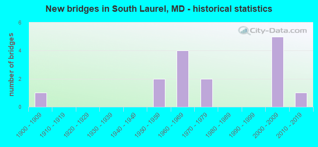
- New bridges - historical statistics
- 11900-1909
- 21950-1959
- 41960-1969
- 21970-1979
- 52000-2009
- 12010-2019
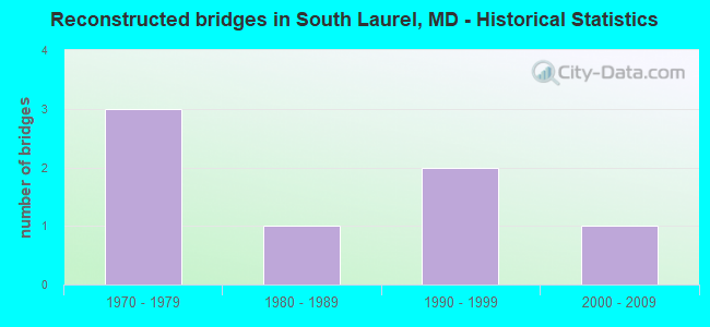
- Reconstructed bridges - Historical Statistics
- 31970-1979
- 11980-1989
- 21990-1999
- 12000-2009
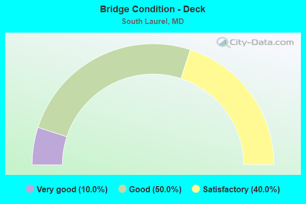
- Bridge Condition - Deck
- 10.0%Very good
- 50.0%Good
- 40.0%Satisfactory

- Bridge Condition - Superstructure
- 10.0%Very good
- 40.0%Good
- 50.0%Satisfactory
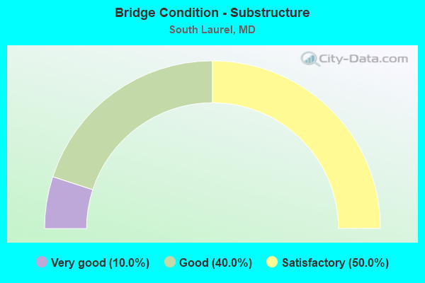
- Bridge Condition - Substructure
- 10.0%Very good
- 40.0%Good
- 50.0%Satisfactory
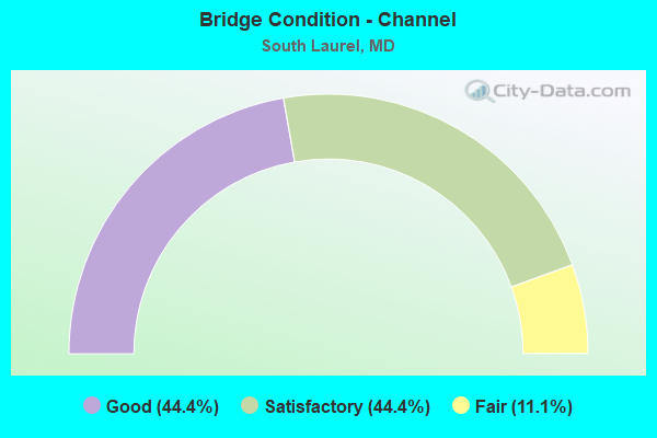
- Bridge Condition - Channel
- 44.4%Good
- 44.4%Satisfactory
- 11.1%Fair
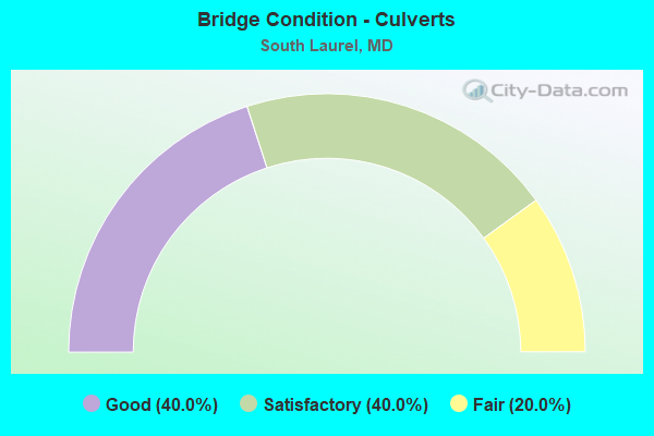
- Bridge Condition - Culverts
- 40.0%Good
- 40.0%Satisfactory
- 20.0%Fair
Find on map >> Show street view
Structure Number: 51640-0001, Location: TRACT #9 / CENTRAL TRACT (Lat: 39.045167, Lng: -76.788667), Route carried "on" structure: Federal lands road , Year Built: 1907, Year Reconstructed: 2014, Status: Posted for load, Structure Length: 2.74m (8.99ft), Average Daily Traffic: 25 (year 2021), Average Future Daily Traffic: 40 (year 2041), Features Intersected: PATUXENT RIVER, Facility Carried by Structure: DUVALL BRIDGE ROAD
Minimum Vertical Clearance: 30.48m (100.00ft), Kilometerpoint: 0.322, Lanes on structure: 1, Owner: Bureau of Fish and Wildlife, Approaching Roadway Width: 4.6m (15.1ft), Material/Design: Steel, Design/Construction: Truss - Thru, Number Of Spans In Main Unit: 1, Length of Maximum Span: 26.5m (86.9ft), Curb or Sidewalk Widths: Left: 0.5m (1.6ft), Right: 0.2m (0.7ft), Curb-To-Curb Width: 3.9m (12.8ft), Out-to-Out Width: 4.4m (14.4ft)
Condition: Deck: Satisfactory, Superstructure: Good, Substructure: Satisfactory, Channel: Good, Operating Rating: 27.2 metric tons, Method Used To Determine Operating Rating: Allowable Stress (AS), Inventory Rating: 16.3 metric tons, Method Used To Determine Inventory Rating: Allowable Stress (AS), Structural Evaluation: Somewhat better than minimum adequacy, Deck Geometry: Meets minimum limits, Waterway Adequacy: Better than present minimum criteria, Approach Roadway Alignment: Somewhat better than minimum adequacy, Designated Inspection Frequency: Every 24 months, Critical Feature Inspection Frequency: Every 24 months, Inspection Date: August 2021, Critical Feature Inspection Date: August 2021, Deck Structure Type: Wood or Timber, Wearing Surface/Protective System: Wearing Surface: Wood or Timber
Find on map >> Show street view
Structure Number: 51640-68865, Location: Central/NorthTractBoundry (Lat: 39.048333, Lng: -76.787000), Route carried "on" structure: Federal lands road , Year Built: 2017, Status: Posted for load, Structure Length: 0.94m (3.08ft), Average Daily Traffic: 5 (year 2021), Average Future Daily Traffic: 10 (year 2041), Design Load: HL 93, Features Intersected: Duvall Mill Millrace, Facility Carried by Structure: Duvall Bridge Road
Minimum Vertical Clearance: 30.48m (100.00ft), Kilometerpoint: 0.579, Lanes on structure: 1, Owner: Bureau of Fish and Wildlife, Approaching Roadway Width: 3.7m (12.1ft), Material/Design: Steel, Design/Construction: Stringer/Multi-beam, Number Of Spans In Main Unit: 1, Length of Maximum Span: 8.8m (28.9ft), Curb-To-Curb Width: 3.7m (12.1ft), Out-to-Out Width: 3.7m (12.1ft)
Condition: Deck: Good, Superstructure: Good, Substructure: Very good, Channel: Good, Operating Rating: 47.2 metric tons, Method Used To Determine Operating Rating: Load and Resistance Factor (LRFR), Inventory Rating: 36.3 metric tons, Method Used To Determine Inventory Rating: Load and Resistance Factor (LRFR), Structural Evaluation: Better than present minimum criteria, Deck Geometry: Meets minimum limits, Waterway Adequacy: Better than present minimum criteria, Approach Roadway Alignment: Equal to present minimum criteria, Designated Inspection Frequency: Every 24 months, Inspection Date: August 2021, Deck Structure Type: Corrugated Steel, Wearing Surface/Protective System: Wearing Surface: Gravel
Find on map >> Show street view
Structure Number: 10000016020602, Location: 0.99 MILE SOUTH OF MD 198 (Lat: 39.081889, Lng: -76.847700), Route carried "on" structure: State highway 197, Year Built: 1969, Year Reconstructed: 1976, Status: Open, Structure Length: 1.07m (3.51ft), Average Daily Traffic: 30,022 (year 2009), Truck Traffic: 8%, Average Future Daily Traffic: 32,701 (year 2026), Design Load: HS 20, Features Intersected: CROW BRANCH
Minimum Vertical Clearance: 30+ m (98+ ft), Kilometerpoint: 21.963, Lanes on structure: 4, Base Highway Network: Yes, Owner: State Highway Agency, Approaching Roadway Width: 26.8m (87.9ft), Skew: 4 degrees, Material/Design: Concrete, Design/Construction: Culvert, Length of Maximum Span: 2.7m (8.9ft)
Condition: Channel: Fair, Culverts: Good, Operating Rating: 32.7 metric tons, Method Used To Determine Operating Rating: Field evaluation and documented engineering judgment, Inventory Rating: 32.7 metric tons, Method Used To Determine Inventory Rating: Field evaluation and documented engineering judgment, Structural Evaluation: Better than present minimum criteria, Waterway Adequacy: Equal to present desirable criteria, Approach Roadway Alignment: Equal to present desirable criteria, Designated Inspection Frequency: Every 24 months, Inspection Date: Febuary 2020
Find on map >> Show street view
Structure Number: 10000016020702, Location: 1.9 MILES SOUTH OF MD 198 (Lat: 39.070419, Lng: -76.843372), Route carried "on" structure: State highway 197, Year Built: 1969, Year Reconstructed: 1976, Status: Open, Structure Length: 0.70m (2.30ft), Average Daily Traffic: 44,222 (year 2009), Truck Traffic: 8%, Average Future Daily Traffic: 57,446 (year 2026), Design Load: HS 20, Features Intersected: BR OF PATUXENT RIVER
Minimum Vertical Clearance: 30+ m (98+ ft), Kilometerpoint: 20.499, Lanes on structure: 5, Base Highway Network: Yes, Owner: State Highway Agency, Approaching Roadway Width: 33.5m (109.9ft), Material/Design: Concrete, Design/Construction: Culvert, Length of Maximum Span: 3.0m (9.8ft)
Condition: Channel: Satisfactory, Culverts: Satisfactory, Operating Rating: 32.7 metric tons, Method Used To Determine Operating Rating: Field evaluation and documented engineering judgment, Inventory Rating: 32.7 metric tons, Method Used To Determine Inventory Rating: Field evaluation and documented engineering judgment, Structural Evaluation: Equal to present minimum criteria, Waterway Adequacy: Equal to present desirable criteria, Approach Roadway Alignment: Equal to present desirable criteria, Designated Inspection Frequency: Every 24 months, Inspection Date: January 2021
Find on map >> Show street view
Structure Number: 10000016020802, Location: 0.254 MILE N OF MD 295 (Lat: 39.065056, Lng: -76.839500), Route carried "on" structure: State highway 197, Year Built: 1970, Year Reconstructed: 1976, Status: Open, Structure Length: 0.82m (2.69ft), Average Daily Traffic: 44,222 (year 2009), Truck Traffic: 8%, Average Future Daily Traffic: 57,446 (year 2026), Design Load: HS 20, Features Intersected: BR OF PATUXENT RIVER
Minimum Vertical Clearance: 30+ m (98+ ft), Kilometerpoint: 19.804, Lanes on structure: 6, Base Highway Network: Yes, Owner: State Highway Agency, Approaching Roadway Width: 29.9m (98.1ft), Skew: 4 degrees, Material/Design: Concrete, Design/Construction: Culvert, Length of Maximum Span: 2.7m (8.9ft)
Condition: Channel: Good, Culverts: Good, Operating Rating: 32.7 metric tons, Method Used To Determine Operating Rating: Field evaluation and documented engineering judgment, Inventory Rating: 32.7 metric tons, Method Used To Determine Inventory Rating: Field evaluation and documented engineering judgment, Structural Evaluation: Better than present minimum criteria, Waterway Adequacy: Equal to present desirable criteria, Approach Roadway Alignment: Equal to present desirable criteria, Designated Inspection Frequency: Every 24 months, Inspection Date: January 2021
Find on map >> Show street view
Structure Number: 200000AA400101, Location: ON THE PG COUNTY LINE (Lat: 39.071689, Lng: -76.837833), Route carried "on" structure: County highway 4912, Year Built: 1966, Year Reconstructed: 2001, Status: Open, Structure Length: 1.59m (5.22ft), Average Daily Traffic: 5,944 (year 2018), Truck Traffic: 5%, Average Future Daily Traffic: 6,900 (year 2040), Design Load: HS 25 or greater, Features Intersected: PATUXENT RIVER, Facility Carried by Structure: BROCK BRIDGE ROAD
Minimum Vertical Clearance: 30+ m (98+ ft), Kilometerpoint: 9.075, Lanes on structure: 2, Owner: County Highway Agency, Approaching Roadway Width: 7.3m (24.0ft), Material/Design: Prestressed concrete, Design/Construction: Box Beam or Girders - Multiple, Number Of Spans In Main Unit: 1, Length of Maximum Span: 14.9m (48.9ft), Curb-To-Curb Width: 9.2m (30.2ft), Out-to-Out Width: 10.1m (33.1ft)
Condition: Deck: Very good, Superstructure: Very good, Substructure: Good, Channel: Satisfactory, Operating Rating: 45.4 metric tons, Method Used To Determine Operating Rating: Load Factor (LF), Inventory Rating: 27.2 metric tons, Method Used To Determine Inventory Rating: Load Factor (LF), Structural Evaluation: Equal to present minimum criteria, Deck Geometry: High priority of corrective action, Waterway Adequacy: Somewhat better than minimum adequacy, Approach Roadway Alignment: Equal to present minimum criteria, Length Of Structure Improvement: 1.49m (4.89ft), Designated Inspection Frequency: Every 24 months, Inspection Date: November 2020, Bridge Improvement Cost: $58,000, Roadway Improvement Cost: $5,000, Total Project Cost: $63,000, Deck Structure Type: Concrete Cast-file-Place, Wearing Surface/Protective System: Wearing Surface: Integral Concrete, Deck Protection: Epoxy Coated Reinforcing
Find on map >> Show street view
Structure Number: 200000P-017003, Location: 0.84 MI SW OF MD 197 (Lat: 39.065511, Lng: -76.854686), Route carried "on" structure: County highway 70, Year Built: 1971, Status: Open, Structure Length: 0.67m (2.20ft), Average Daily Traffic: 6,194 (year 2015), Truck Traffic: 10%, Average Future Daily Traffic: 9,575 (year 2037), Design Load: H 20, Features Intersected: DEERFIELD RUN, Facility Carried by Structure: MONTPELIER DRIVE
Minimum Vertical Clearance: 30+ m (98+ ft), Kilometerpoint: 1.352, Lanes on structure: 3, Owner: County Highway Agency, Approaching Roadway Width: 15.9m (52.2ft), Skew: 2 degrees, Material/Design: Concrete, Design/Construction: Culvert, Length of Maximum Span: 3.0m (9.8ft), Curb or Sidewalk Widths: Left: 1.2m (3.9ft), Right: 0.0m
Condition: Channel: Satisfactory, Culverts: Satisfactory, Operating Rating: 32.7 metric tons, Method Used To Determine Operating Rating: Field evaluation and documented engineering judgment, Inventory Rating: 32.7 metric tons, Method Used To Determine Inventory Rating: Field evaluation and documented engineering judgment, Structural Evaluation: Equal to present minimum criteria, Waterway Adequacy: Somewhat better than minimum adequacy, Approach Roadway Alignment: Equal to present desirable criteria, Designated Inspection Frequency: Every 24 months, Inspection Date: Febuary 2021
Find on map >> Show street view
Structure Number: 200000P-017103, Location: 0.07 MI W OF MD 197 (Lat: 39.080431, Lng: -76.849344), Route carried "on" structure: County highway 2645, Year Built: 1964, Status: Open, Structure Length: 0.76m (2.49ft), Average Daily Traffic: 4,990 (year 2018), Truck Traffic: 10%, Average Future Daily Traffic: 7,430 (year 2040), Design Load: H 20, Features Intersected: TRIB TO CROW BRANCH, Facility Carried by Structure: BRIARWOOD DRIVE
Minimum Vertical Clearance: 30+ m (98+ ft), Kilometerpoint: 0.547, Lanes on structure: 2, Owner: County Highway Agency, Approaching Roadway Width: 11.0m (36.1ft), Skew: 1 degrees, Material/Design: Steel, Design/Construction: Culvert, Number Of Spans In Main Unit: 2, Length of Maximum Span: 3.4m (11.2ft), Curb or Sidewalk Widths: Left: 1.2m (3.9ft), Right: 1.2m (3.9ft)
Condition: Channel: Satisfactory, Culverts: Fair, Structural Evaluation: Somewhat better than minimum adequacy, Waterway Adequacy: Somewhat better than minimum adequacy, Approach Roadway Alignment: Equal to present desirable criteria, Designated Inspection Frequency: Every 24 months, Inspection Date: January 2021
Find on map >> Show street view
Structure Number: 2001004P, Location: CAPITAL BELTWAY TO EXIT 2 (Lat: 39.033639, Lng: -76.849944), Route carried "on" structure: Federal lands road , Year Built: 1950, Year Reconstructed: 1990, Status: Posted for load, Structure Length: 1.92m (6.30ft), Average Daily Traffic: 10,000 (year 2005), Average Future Daily Traffic: 12,000 (year 2025), Design Load: HS 15, Features Intersected: BEAVER DAM CREEK, Facility Carried by Structure: POWDER MILL ROAD
Minimum Vertical Clearance: 30+ m (98+ ft), Kilometerpoint: 0.000, Lanes on structure: 2, Owner: USDA/ARS, Approaching Roadway Width: 8.5m (27.9ft), Material/Design: Steel, Design/Construction: Stringer/Multi-beam, Number Of Spans In Main Unit: 1, Number Of Approach Spans: 2, Length of Maximum Span: 8.5m (27.9ft), Curb-To-Curb Width: 9.0m (29.5ft), Out-to-Out Width: 9.9m (32.5ft)
Condition: Deck: Good, Superstructure: Good, Substructure: Good, Channel: Good, Operating Rating: 39.9 metric tons, Method Used To Determine Operating Rating: Load Factor (LF), Inventory Rating: 23.6 metric tons, Method Used To Determine Inventory Rating: Load Factor (LF), Structural Evaluation: Somewhat better than minimum adequacy, Deck Geometry: High priority of replacement, Waterway Adequacy: Equal to present desirable criteria, Approach Roadway Alignment: Equal to present desirable criteria, Designated Inspection Frequency: Every 24 months, Inspection Date: August 2019, Deck Structure Type: Concrete Cast-file-Place, Wearing Surface/Protective System: Wearing Surface: Monolithic Concrete
Find on map >> Show street view
Structure Number: 3530009P, Location: 1.8 MILES SOUTH OF MD ROU (Lat: 39.033361, Lng: -76.852056), Route carried "on" structure: Federal lands road 1, Year Built: 1953, Year Reconstructed: 1994, Status: Open, Structure Length: 2.10m (6.89ft), Average Daily Traffic: 80,000 (year 2013), Truck Traffic: 1%, Average Future Daily Traffic: 103,000 (year 2033), Design Load: H 20, Features Intersected: MD ROUTE 212, Facility Carried by Structure: BW PARKWAY
Minimum Vertical Clearance: 30+ m (98+ ft), Kilometerpoint: 15.640, Lanes on structure: 4, Lanes under structure: 2, Owner: National Park Service, Approaching Roadway Width: 22.8m (74.8ft), Skew: 33 degrees, Material/Design: Concrete, Design/Construction: Frame, Number Of Spans In Main Unit: 1, Length of Maximum Span: 15.5m (50.9ft), Curb-To-Curb Width: 22.8m (74.8ft), Out-to-Out Width: 33.5m (109.9ft)
Condition: Deck: Satisfactory, Superstructure: Satisfactory, Substructure: Satisfactory, Inventory Rating: 78.0 metric tons, Method Used To Determine Inventory Rating: Load Factor (LF), Structural Evaluation: Equal to present minimum criteria, Deck Geometry: Superior to present desirable criteria, Underclear: High priority of corrective action, Approach Roadway Alignment: Equal to present desirable criteria, Designated Inspection Frequency: Every 24 months, Inspection Date: Febuary 2020, Bridge Improvement Cost: $55,000, Roadway Improvement Cost: $6,000, Total Project Cost: $83,000 ( Estimate for 2018), Deck Structure Type: Concrete Cast-file-Place, Wearing Surface/Protective System: Wearing Surface: Bituminous
Find on map >> Show street view
Structure Number: 3530034P, Location: 1.9 MILES NORTH OF MD ROU (Lat: 39.054972, Lng: -76.838722), Route carried "on" structure: Ramp Federal lands road 1, Year Built: 2001, Status: Open, Structure Length: 3.53m (11.58ft), Average Daily Traffic: 20,000 (year 2013), Average Future Daily Traffic: 25,000 (year 2033), Design Load: HS 20, Features Intersected: MD ROUTE 197 (EBL), Facility Carried by Structure: BW PARKWAY (RAMP C
Minimum Vertical Clearance: 30+ m (98+ ft), Kilometerpoint: 18.640, Lanes on structure: 2, Lanes under structure: 3, Owner: National Park Service, Approaching Roadway Width: 12.1m (39.7ft), Skew: 3 degrees, Material/Design: Prestressed concrete, Design/Construction: Box Beam or Girders - Single/Spread, Number Of Spans In Main Unit: 1, Length of Maximum Span: 33.8m (110.9ft), Curb-To-Curb Width: 12.3m (40.4ft), Out-to-Out Width: 12.9m (42.3ft)
Condition: Deck: Good, Superstructure: Good, Substructure: Good, Operating Rating: 87.1 metric tons, Method Used To Determine Operating Rating: Load Factor (LF), Inventory Rating: 51.7 metric tons, Method Used To Determine Inventory Rating: Load Factor (LF), Structural Evaluation: Better than present minimum criteria, Deck Geometry: Superior to present desirable criteria, Underclear: Superior to present desirable criteria, Approach Roadway Alignment: Equal to present desirable criteria, Designated Inspection Frequency: Every 24 months, Inspection Date: Febuary 2020, Bridge Improvement Cost: $120,000, Roadway Improvement Cost: $12,000, Total Project Cost: $180,000 ( Estimate for 2018), Deck Structure Type: Concrete Cast-file-Place
Find on map >> Show street view
Structure Number: 3530035P, Location: 1.9 MILES NORTH OF MD ROU (Lat: 39.055833, Lng: -76.839278), Route carried "on" structure: Federal lands road 1, Year Built: 2001, Status: Open, Structure Length: 4.39m (14.40ft), Average Daily Traffic: 88,000 (year 2013), Average Future Daily Traffic: 105,600 (year 2033), Design Load: HS 20, Features Intersected: MD ROUTE 197 (EBL), Facility Carried by Structure: BW PARKWAY (NBL)
Minimum Vertical Clearance: 30+ m (98+ ft), Kilometerpoint: 18.640, Lanes on structure: 2, Lanes under structure: 2, Owner: National Park Service, Approaching Roadway Width: 10.6m (34.8ft), Skew: 4 degrees, Material/Design: Prestressed concrete, Design/Construction: Box Beam or Girders - Single/Spread, Number Of Spans In Main Unit: 1, Length of Maximum Span: 42.8m (140.4ft), Curb-To-Curb Width: 10.7m (35.1ft), Out-to-Out Width: 11.3m (37.1ft)
Condition: Deck: Satisfactory, Superstructure: Satisfactory, Substructure: Good, Inventory Rating: 57.2 metric tons, Method Used To Determine Inventory Rating: Load Factor (LF), Structural Evaluation: Equal to present minimum criteria, Deck Geometry: Meets minimum limits, Underclear: Superior to present desirable criteria, Approach Roadway Alignment: Equal to present desirable criteria, Designated Inspection Frequency: Every 24 months, Inspection Date: Febuary 2020, Bridge Improvement Cost: $120,000, Roadway Improvement Cost: $12,000, Total Project Cost: $180,000 ( Estimate for 2018), Deck Structure Type: Concrete Cast-file-Place
Find on map >> Show street view
Structure Number: 3530036P, Location: 1.9 MILES NORTH OF MD ROU (Lat: 39.056806, Lng: -76.839889), Route carried "on" structure: Federal lands road 1, Year Built: 2001, Status: Open, Structure Length: 5.50m (18.04ft), Average Daily Traffic: 88,000 (year 2013), Average Future Daily Traffic: 110,000 (year 2033), Design Load: HS 20, Features Intersected: MD ROUTE 197 (EBL), Facility Carried by Structure: BW PARKWAY (SBL)
Minimum Vertical Clearance: 30+ m (98+ ft), Kilometerpoint: 18.640, Lanes on structure: 2, Lanes under structure: 2, Owner: National Park Service, Approaching Roadway Width: 10.9m (35.8ft), Skew: 5 degrees, Material/Design: Prestressed concrete, Design/Construction: Box Beam or Girders - Single/Spread, Number Of Spans In Main Unit: 1, Length of Maximum Span: 53.3m (174.9ft), Curb-To-Curb Width: 11.0m (36.1ft), Out-to-Out Width: 11.6m (38.1ft)
Condition: Deck: Good, Superstructure: Satisfactory, Substructure: Satisfactory, Inventory Rating: 72.6 metric tons, Method Used To Determine Inventory Rating: Load Factor (LF), Structural Evaluation: Equal to present minimum criteria, Deck Geometry: Somewhat better than minimum adequacy, Underclear: Superior to present desirable criteria, Approach Roadway Alignment: Equal to present desirable criteria, Designated Inspection Frequency: Every 24 months, Inspection Date: Febuary 2020, Bridge Improvement Cost: $60,000, Roadway Improvement Cost: $6,000, Total Project Cost: $90,000 ( Estimate for 2018), Deck Structure Type: Concrete Cast-file-Place
Find on map >> Show street view
Structure Number: 3530037P, Location: 1.8 MILES NORTH OF MD ROU (Lat: 39.058028, Lng: -76.838250), Route carried "on" structure: Federal lands road 1, Year Built: 2001, Status: Open, Structure Length: 4.46m (14.63ft), Average Daily Traffic: 88,000 (year 2013), Average Future Daily Traffic: 110,000 (year 2033), Design Load: HS 20, Features Intersected: MD ROUTE 197 (WBL), Facility Carried by Structure: BW PARKWAY (NBL)
Minimum Vertical Clearance: 30+ m (98+ ft), Kilometerpoint: 18.670, Lanes on structure: 2, Lanes under structure: 3, Owner: National Park Service, Approaching Roadway Width: 10.6m (34.8ft), Skew: 4 degrees, Material/Design: Prestressed concrete, Design/Construction: Box Beam or Girders - Single/Spread, Number Of Spans In Main Unit: 1, Length of Maximum Span: 43.6m (143.0ft), Curb-To-Curb Width: 10.7m (35.1ft), Out-to-Out Width: 11.3m (37.1ft)
Condition: Deck: Satisfactory, Superstructure: Satisfactory, Substructure: Satisfactory, Operating Rating: 88.9 metric tons, Method Used To Determine Operating Rating: Load Factor (LF), Inventory Rating: 53.5 metric tons, Method Used To Determine Inventory Rating: Load Factor (LF), Structural Evaluation: Equal to present minimum criteria, Deck Geometry: Meets minimum limits, Underclear: Superior to present desirable criteria, Approach Roadway Alignment: Equal to present desirable criteria, Designated Inspection Frequency: Every 24 months, Inspection Date: Febuary 2020, Bridge Improvement Cost: $135,000, Roadway Improvement Cost: $14,000, Total Project Cost: $203,000 ( Estimate for 2018), Deck Structure Type: Concrete Cast-file-Place
Find on map >> Show street view
Structure Number: 3530038P, Location: 1.9 MILES NORTH OF MD ROU (Lat: 39.058806, Lng: -76.838778), Route carried "on" structure: Federal lands road 1, Year Built: 2001, Status: Open, Structure Length: 4.27m (14.01ft), Average Daily Traffic: 88,000 (year 2013), Average Future Daily Traffic: 110,000 (year 2033), Design Load: HS 20, Features Intersected: MD ROUTE 197 (WBL), Facility Carried by Structure: BW PARKWAY (SBL)
Minimum Vertical Clearance: 30+ m (98+ ft), Kilometerpoint: 18.670, Lanes on structure: 3, Lanes under structure: 3, Owner: National Park Service, Approaching Roadway Width: 14.3m (46.9ft), Skew: 4 degrees, Material/Design: Prestressed concrete, Design/Construction: Box Beam or Girders - Single/Spread, Number Of Spans In Main Unit: 1, Length of Maximum Span: 41.5m (136.2ft), Curb-To-Curb Width: 14.5m (47.6ft), Out-to-Out Width: 15.1m (49.5ft)
Condition: Deck: Good, Superstructure: Satisfactory, Substructure: Satisfactory, Operating Rating: 68.0 metric tons, Method Used To Determine Operating Rating: Load Factor (LF), Inventory Rating: 40.8 metric tons, Method Used To Determine Inventory Rating: Load Factor (LF), Structural Evaluation: Equal to present minimum criteria, Deck Geometry: Meets minimum limits, Underclear: Superior to present desirable criteria, Approach Roadway Alignment: Equal to present desirable criteria, Designated Inspection Frequency: Every 24 months, Inspection Date: Febuary 2020, Bridge Improvement Cost: $70,000, Roadway Improvement Cost: $7,000, Total Project Cost: $105,000 ( Estimate for 2018), Deck Structure Type: Concrete Cast-file-Place