Bridge Statistics for South Monroe, Michigan (MI)
Condition, Traffic, Stress, Structural Evaluation, Project Costs
- National Bridge Inventory (NBI) Statistics
- 14Number of bridges
- 92ft / 28.5mTotal length
- 287,965Total average daily traffic
- 62,179Total average daily truck traffic
- National Bridge Inventory (NBI) Registered Bridges for South Monroe
- No street view available for this location
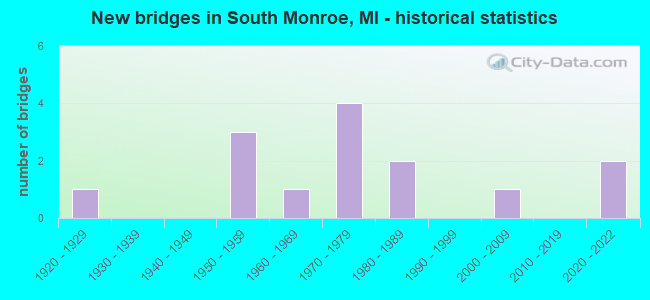
- New bridges - historical statistics
- 11920-1929
- 31950-1959
- 11960-1969
- 41970-1979
- 21980-1989
- 12000-2009
- 22020-2022
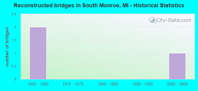
- Reconstructed bridges - Historical Statistics
- 21960-1969
- 01970-1979
- 01980-1989
- 01990-1999
- 12000-2009
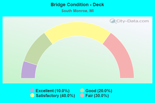
- Bridge Condition - Deck
- 10.0%Excellent
- 20.0%Good
- 40.0%Satisfactory
- 30.0%Fair
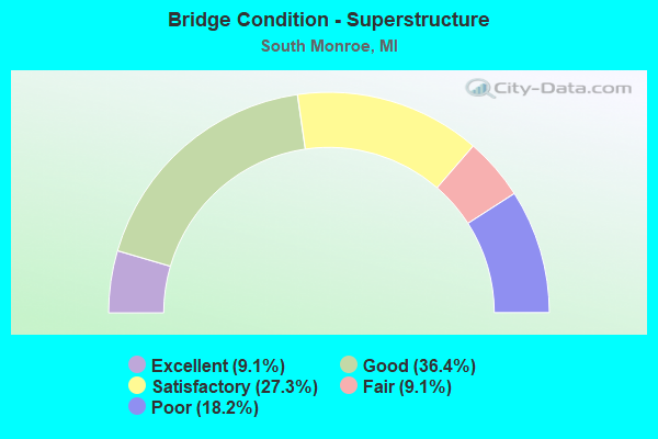
- Bridge Condition - Superstructure
- 9.1%Excellent
- 36.4%Good
- 27.3%Satisfactory
- 9.1%Fair
- 18.2%Poor
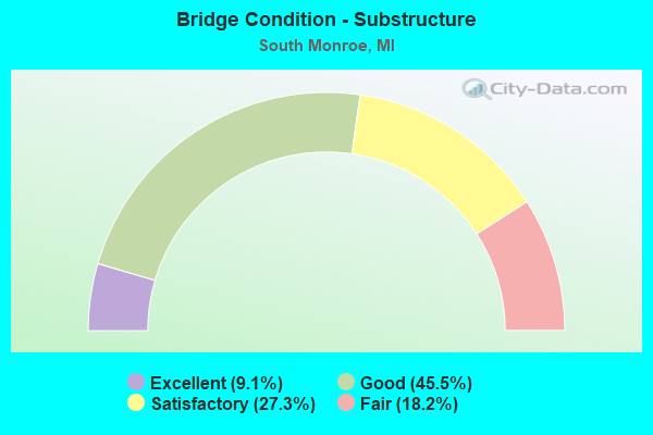
- Bridge Condition - Substructure
- 9.1%Excellent
- 45.5%Good
- 27.3%Satisfactory
- 18.2%Fair
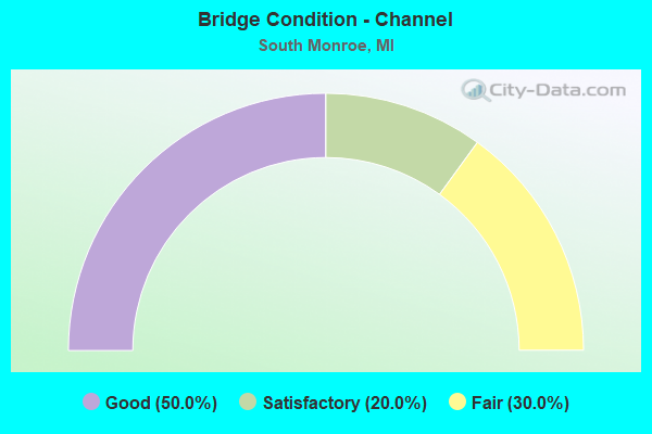
- Bridge Condition - Channel
- 50.0%Good
- 20.0%Satisfactory
- 30.0%Fair
Find on map >> Show street view
Structure Number: 7122, Location: 4.1 MI SW OF M-50 (Lat: 41.869447, Lng: -83.456539), Route carried "on" structure: US 24, Year Built: 1924, Status: Open, Structure Length: 1.98m (6.50ft), Average Daily Traffic: 7,446 (year 2007), Truck Traffic: 8%, Average Future Daily Traffic: 8,475 (year 2018), Design Load: H 15, Features Intersected: OTTER CREEK
Minimum Vertical Clearance: 30.48m (100.00ft), Kilometerpoint: 17.419, Lanes on structure: 2, Base Highway Network: Yes (Inventory Route: 430, Subroute: 1), Owner: State Highway Agency, Approaching Roadway Width: 12.2m (40.0ft), Material/Design: Concrete, Design/Construction: Arch - Deck, Number Of Spans In Main Unit: 1, Length of Maximum Span: 19.8m (65.0ft), Curb-To-Curb Width: 13.9m (45.6ft), Out-to-Out Width: 14.8m (48.6ft)
Condition: Superstructure: Poor, Substructure: Fair, Channel: Good, Operating Rating: 51.5 metric tons, Method Used To Determine Operating Rating: Load Factor (LF) rating reported by rating factor (RF) method using MS18 loading, Inventory Rating: 30.8 metric tons, Method Used To Determine Inventory Rating: Load Factor (LF) rating reported by rating factor (RF) method using MS18 loading, Structural Evaluation: Meets minimum limits, Deck Geometry: Superior to present desirable criteria, Waterway Adequacy: Equal to present desirable criteria, Approach Roadway Alignment: Equal to present desirable criteria, Designated Inspection Frequency: Every 12 months, Inspection Date: August 2021, Deck Structure Type: Concrete Cast-file-Place, Wearing Surface/Protective System: Wearing Surface: Bituminous
Find on map >> Show street view
Structure Number: 7138, Location: 4.7 MI SW OF M-50 (Lat: 41.866944, Lng: -83.453339), Route carried "on" structure: State highway 125, Year Built: 1964, Year Reconstructed: 2006, Status: Open, Structure Length: 2.45m (8.04ft), Average Daily Traffic: 8,305 (year 2007), Truck Traffic: 3%, Average Future Daily Traffic: 9,636 (year 2018), Design Load: HS 20, Features Intersected: OTTER CREEK
Minimum Vertical Clearance: 30.48m (100.00ft), Kilometerpoint: 16.474, Lanes on structure: 4, Owner: State Highway Agency, Approaching Roadway Width: 15.9m (52.2ft), Material/Design: Prestressed concrete, Design/Construction: Stringer/Multi-beam, Number Of Spans In Main Unit: 2, Length of Maximum Span: 12.3m (40.4ft), Curb-To-Curb Width: 15.9m (52.2ft), Out-to-Out Width: 17.1m (56.1ft)
Condition: Deck: Satisfactory, Superstructure: Satisfactory, Substructure: Fair, Channel: Fair, Operating Rating: 65.4 metric tons, Method Used To Determine Operating Rating: Load Factor (LF) rating reported by rating factor (RF) method using MS18 loading, Inventory Rating: 39.2 metric tons, Method Used To Determine Inventory Rating: Load Factor (LF) rating reported by rating factor (RF) method using MS18 loading, Structural Evaluation: Somewhat better than minimum adequacy, Deck Geometry: Meets minimum limits, Waterway Adequacy: Equal to present desirable criteria, Approach Roadway Alignment: Equal to present desirable criteria, Designated Inspection Frequency: Every 24 months, Inspection Date: August 2021, Deck Structure Type: Concrete Cast-file-Place, Wearing Surface/Protective System: Wearing Surface: Latex Concrete, Deck Protection: Epoxy Coated Reinforcing
Find on map >> Show street view
Structure Number: 7139, Location: 1.1 MI SW OF M-50 (Lat: 41.904403, Lng: -83.407847), Route carried "on" structure: State highway 125, Year Built: 1985, Status: Open, Structure Length: 1.65m (5.41ft), Average Daily Traffic: 18,902 (year 2007), Truck Traffic: 3%, Average Future Daily Traffic: 17,000 (year 2017), Design Load: HS 20, Features Intersected: PLUM CREEK
Minimum Vertical Clearance: 30.48m (100.00ft), Kilometerpoint: 22.194, Lanes on structure: 5, Owner: State Highway Agency, Approaching Roadway Width: 24.4m (80.1ft), Material/Design: Prestressed concrete, Design/Construction: Box Beam or Girders - Multiple, Number Of Spans In Main Unit: 1, Length of Maximum Span: 15.2m (49.9ft), Curb-To-Curb Width: 15.9m (52.2ft), Out-to-Out Width: 17.1m (56.1ft)
Condition: Deck: Satisfactory, Superstructure: Fair, Substructure: Satisfactory, Channel: Fair, Operating Rating: 43.7 metric tons, Method Used To Determine Operating Rating: Load Factor (LF) rating reported by rating factor (RF) method using MS18 loading, Inventory Rating: 16.8 metric tons, Method Used To Determine Inventory Rating: Load Factor (LF) rating reported by rating factor (RF) method using MS18 loading, Structural Evaluation: Meets minimum limits, Deck Geometry: High priority of replacement, Waterway Adequacy: Equal to present desirable criteria, Approach Roadway Alignment: Equal to present minimum criteria, Designated Inspection Frequency: Every 24 months, Inspection Date: August 2021, Bridge Improvement Cost: $120,000, Deck Structure Type: Concrete Cast-file-Place, Wearing Surface/Protective System: Wearing Surface: Latex Concrete, Deck Protection: Epoxy Coated Reinforcing
Find on map >> Show street view
Structure Number: 7164, Location: 4.2 MI SW OF M-50 (Lat: 41.874989, Lng: -83.397406), Route carried "on" structure: Interstate 75, Year Built: 1954, Year Reconstructed: 1974, Status: Open, Structure Length: 1.06m (3.48ft), Average Daily Traffic: 30,558 (year 2007), Truck Traffic: 24%, Average Future Daily Traffic: 34,683 (year 2018), Design Load: HS 20, Features Intersected: LAPLAISANCE CREEK
Minimum Vertical Clearance: 30.48m (100.00ft), Kilometerpoint: 17.882, Lanes on structure: 3, Base Highway Network: Yes (Inventory Route: 122, Subroute: 10), Owner: State Highway Agency, Approaching Roadway Width: 16.4m (53.8ft), Skew: 10 degrees, Material/Design: Concrete, Design/Construction: Tee Beam, Number Of Spans In Main Unit: 1, Length of Maximum Span: 10.6m (34.8ft), Curb-To-Curb Width: 17.3m (56.8ft), Out-to-Out Width: 17.8m (58.4ft)
Condition: Deck: Satisfactory, Superstructure: Good, Substructure: Good, Channel: Good, Operating Rating: 71.9 metric tons, Method Used To Determine Operating Rating: Load Factor (LF) rating reported by rating factor (RF) method using MS18 loading, Inventory Rating: 43.4 metric tons, Method Used To Determine Inventory Rating: Load Factor (LF) rating reported by rating factor (RF) method using MS18 loading, Structural Evaluation: Better than present minimum criteria, Deck Geometry: Better than present minimum criteria, Waterway Adequacy: Equal to present desirable criteria, Approach Roadway Alignment: Better than present minimum criteria, Designated Inspection Frequency: Every 24 months, Inspection Date: June 2021, Deck Structure Type: Concrete Cast-file-Place, Wearing Surface/Protective System: Wearing Surface: Latex Concrete
Find on map >> Show street view
Structure Number: 7165, Location: 4.2 MI SW OF M-50 (Lat: 41.875139, Lng: -83.397625), Route carried "on" structure: Interstate 75, Year Built: 1954, Year Reconstructed: 1974, Status: Open, Structure Length: 1.06m (3.48ft), Average Daily Traffic: 30,558 (year 2007), Truck Traffic: 24%, Average Future Daily Traffic: 34,683 (year 2018), Design Load: HS 20, Features Intersected: LAPLAISANCE CREEK
Minimum Vertical Clearance: 30.48m (100.00ft), Kilometerpoint: 17.888, Lanes on structure: 4, Base Highway Network: Yes (Inventory Route: 122, Subroute: 9), Owner: State Highway Agency, Approaching Roadway Width: 20.1m (65.9ft), Skew: 10 degrees, Material/Design: Concrete, Design/Construction: Tee Beam, Number Of Spans In Main Unit: 1, Length of Maximum Span: 10.6m (34.8ft), Curb-To-Curb Width: 21.3m (69.9ft), Out-to-Out Width: 21.8m (71.5ft)
Condition: Deck: Satisfactory, Superstructure: Satisfactory, Substructure: Good, Channel: Good, Operating Rating: 72.9 metric tons, Method Used To Determine Operating Rating: Load Factor (LF) rating reported by rating factor (RF) method using MS18 loading, Inventory Rating: 44.1 metric tons, Method Used To Determine Inventory Rating: Load Factor (LF) rating reported by rating factor (RF) method using MS18 loading, Structural Evaluation: Equal to present minimum criteria, Deck Geometry: Better than present minimum criteria, Waterway Adequacy: Equal to present desirable criteria, Approach Roadway Alignment: Better than present minimum criteria, Designated Inspection Frequency: Every 24 months, Inspection Date: June 2021, Deck Structure Type: Concrete Cast-file-Place, Wearing Surface/Protective System: Wearing Surface: Latex Concrete
Find on map >> Show street view
Structure Number: 7169, Location: 4.2 MI SW OF M-50 (Lat: 41.874647, Lng: -83.396906), Route carried "on" structure: Ramp Interstate 75, Year Built: 1975, Status: Open, Structure Length: 2.07m (6.79ft), Average Daily Traffic: 51,000 (year 1993), Truck Traffic: 27%, Average Future Daily Traffic: 58,650 (year 2013), Design Load: HS 25 or greater, Features Intersected: LAPLAISANCE CREEK
Minimum Vertical Clearance: 30.48m (100.00ft), Kilometerpoint: 0.299, Lanes on structure: 1, Owner: State Highway Agency, Approaching Roadway Width: 7.6m (24.9ft), Skew: 2 degrees, Material/Design: Steel, Design/Construction: Stringer/Multi-beam, Number Of Spans In Main Unit: 1, Length of Maximum Span: 20.7m (67.9ft), Curb-To-Curb Width: 7.7m (25.3ft), Out-to-Out Width: 8.3m (27.2ft)
Condition: Deck: Fair, Superstructure: Good, Substructure: Good, Channel: Good, Operating Rating: 97.2 metric tons, Method Used To Determine Operating Rating: Load Factor (LF) rating reported by rating factor (RF) method using MS18 loading, Inventory Rating: 64.8 metric tons, Method Used To Determine Inventory Rating: Load Factor (LF) rating reported by rating factor (RF) method using MS18 loading, Structural Evaluation: Better than present minimum criteria, Deck Geometry: Better than present minimum criteria, Waterway Adequacy: Equal to present desirable criteria, Approach Roadway Alignment: Equal to present minimum criteria, Designated Inspection Frequency: Every 24 months, Inspection Date: June 2021, Deck Structure Type: Concrete Cast-file-Place, Wearing Surface/Protective System: Wearing Surface: Monolithic Concrete
Find on map >> Show street view
Structure Number: 7182, Location: 2.5 MI SW OF MONROE (Lat: 41.860533, Lng: -83.408242), Route carried "on" structure: County highway , Year Built: 1974, Status: Open, Structure Length: 7.16m (23.49ft), Average Daily Traffic: 610 (year 1995), Truck Traffic: 3%, Average Future Daily Traffic: 610 (year 2015), Design Load: H 20, Features Intersected: I-75, Facility Carried by Structure: MORTAR CREEK RD
Minimum Vertical Clearance: 30.48m (100.00ft), Kilometerpoint: 2.992, Lanes on structure: 2, Lanes under structure: 7, Owner: State Highway Agency, Approaching Roadway Width: 10.3m (33.8ft), Material/Design: Steel, Design/Construction: Stringer/Multi-beam, Number Of Spans In Main Unit: 2, Length of Maximum Span: 36.5m (119.8ft), Curb or Sidewalk Widths: Left: 0.2m (0.7ft), Right: 0.2m (0.7ft), Curb-To-Curb Width: 11.2m (36.7ft), Out-to-Out Width: 12.0m (39.4ft)
Condition: Deck: Fair, Superstructure: Satisfactory, Substructure: Satisfactory, Operating Rating: 80.4 metric tons, Method Used To Determine Operating Rating: Load Factor (LF) rating reported by rating factor (RF) method using MS18 loading, Inventory Rating: 48.0 metric tons, Method Used To Determine Inventory Rating: Load Factor (LF) rating reported by rating factor (RF) method using MS18 loading, Structural Evaluation: Equal to present minimum criteria, Deck Geometry: Better than present minimum criteria, Underclear: Somewhat better than minimum adequacy, Approach Roadway Alignment: Equal to present desirable criteria, Designated Inspection Frequency: Every 24 months, Inspection Date: June 2021, Deck Structure Type: Concrete Cast-file-Place, Wearing Surface/Protective System: Wearing Surface: Monolithic Concrete
Find on map >> Show street view
Structure Number: 7183, Location: 3.9 MI SW OF M-50 (Lat: 41.877858, Lng: -83.394578), Route carried "on" structure: County highway 2016, Year Built: 2021, Status: Open, Structure Length: 5.85m (19.19ft), Average Daily Traffic: 3,500 (year 2017), Truck Traffic: 10%, Average Future Daily Traffic: 4,025 (year 2037), Design Load: Greater than HL93, Features Intersected: I-75, Facility Carried by Structure: LAPLAISANCE RD
Minimum Vertical Clearance: 30.48m (100.00ft), Kilometerpoint: 3.143, Lanes on structure: 2, Lanes under structure: 6, Owner: State Highway Agency, Approaching Roadway Width: 13.4m (44.0ft), Skew: 2 degrees, Material/Design: Prestressed concrete, Design/Construction: Stringer/Multi-beam, Number Of Spans In Main Unit: 2, Length of Maximum Span: 28.5m (93.5ft), Curb-To-Curb Width: 13.4m (44.0ft), Out-to-Out Width: 14.2m (46.6ft)
Condition: Deck: Excellent, Superstructure: Excellent, Substructure: Excellent, Operating Rating: 49.6 metric tons, Method Used To Determine Operating Rating: Load and Resistance Factor Rating (LRFR) rating reported by rating factor(RF) method using HL-93 loadings, Inventory Rating: 38.2 metric tons, Method Used To Determine Inventory Rating: Load and Resistance Factor Rating (LRFR) rating reported by rating factor(RF) method using HL-93 loadings, Structural Evaluation: Superior to present desirable criteria, Deck Geometry: Better than present minimum criteria, Underclear: High priority of corrective action, Approach Roadway Alignment: Equal to present desirable criteria, Designated Inspection Frequency: Every 19 months, Inspection Date: November 2021, Deck Structure Type: Concrete Cast-file-Place, Wearing Surface/Protective System: Wearing Surface: Monolithic Concrete, Deck Protection: Epoxy Coated Reinforcing
Find on map >> Show street view
Structure Number: 7243, Location: 4.2 MI E OF US 25 (Lat: 41.857989, Lng: -83.396414), Route carried "on" structure: County highway , Year Built: 2003, Status: Open, Structure Length: 1.77m (5.81ft), Average Daily Traffic: 350 (year 2014), Truck Traffic: 2%, Average Future Daily Traffic: 403 (year 2034), Design Load: HS 20, Features Intersected: WOODCHUCK CREEK, Facility Carried by Structure: LAPLAISANCE ROAD
Minimum Vertical Clearance: 30.48m (100.00ft), Kilometerpoint: 1.820, Lanes on structure: 2, Owner: County Highway Agency, Approaching Roadway Width: 9.8m (32.2ft), Material/Design: Prestressed concrete, Design/Construction: Box Beam or Girders - Multiple, Number Of Spans In Main Unit: 1, Length of Maximum Span: 17.3m (56.8ft), Curb-To-Curb Width: 9.8m (32.2ft), Out-to-Out Width: 10.5m (34.4ft)
Condition: Deck: Good, Superstructure: Good, Substructure: Good, Channel: Satisfactory, Operating Rating: 82.9 metric tons, Method Used To Determine Operating Rating: Load Factor (LF) rating reported by rating factor (RF) method using MS18 loading, Inventory Rating: 49.9 metric tons, Method Used To Determine Inventory Rating: Load Factor (LF) rating reported by rating factor (RF) method using MS18 loading, Structural Evaluation: Better than present minimum criteria, Deck Geometry: Better than present minimum criteria, Waterway Adequacy: Equal to present desirable criteria, Approach Roadway Alignment: Equal to present minimum criteria, Designated Inspection Frequency: Every 24 months, Inspection Date: November 2021, Deck Structure Type: Concrete Precast Panels, Wearing Surface/Protective System: Wearing Surface: Bituminous, Membrane: Preformed Fabric
Find on map >> Show street view
Structure Number: 7244, Location: 0.25 M S OF I-75 (Lat: 41.874558, Lng: -83.394175), Route carried "on" structure: County highway 2016, Year Built: 1988, Status: Open, Structure Length: 0.74m (2.43ft), Average Daily Traffic: 7,130 (year 2017), Truck Traffic: 1%, Average Future Daily Traffic: 8,198 (year 2037), Design Load: HS 20, Features Intersected: LAPLAISANCE CREEK, Facility Carried by Structure: LAPLAISANCE ROAD
Minimum Vertical Clearance: 30.48m (100.00ft), Kilometerpoint: 3.206, Lanes on structure: 2, Owner: County Highway Agency, Approaching Roadway Width: 12.2m (40.0ft), Material/Design: Concrete, Design/Construction: Culvert, Number Of Spans In Main Unit: 1, Length of Maximum Span: 6.7m (22.0ft), Curb-To-Curb Width: 12.1m (39.7ft), Out-to-Out Width: 17.1m (56.1ft)
Condition: Channel: Good, Culverts: Poor, Operating Rating: 40.2 metric tons, Method Used To Determine Operating Rating: Load Factor (LF) rating reported by rating factor (RF) method using MS18 loading, Inventory Rating: 24.0 metric tons, Method Used To Determine Inventory Rating: Load Factor (LF) rating reported by rating factor (RF) method using MS18 loading, Structural Evaluation: Meets minimum limits, Deck Geometry: Somewhat better than minimum adequacy, Waterway Adequacy: Equal to present desirable criteria, Approach Roadway Alignment: Equal to present minimum criteria, Designated Inspection Frequency: Every 12 months, Inspection Date: September 2021
Find on map >> Show street view
Structure Number: 7367, Location: .04 MI N OF S OTTER CR RD (Lat: 41.874161, Lng: -83.489517), Route carried "on" structure: County highway , Year Built: 1977, Status: Posted for load, Structure Length: 1.61m (5.28ft), Average Daily Traffic: 230 (year 2016), Truck Traffic: 1%, Average Future Daily Traffic: 265 (year 2036), Design Load: H 20, Features Intersected: OTTER CREEK, Facility Carried by Structure: GOUTZ ROAD
Minimum Vertical Clearance: 30.48m (100.00ft), Kilometerpoint: 0.101, Lanes on structure: 2, Owner: County Highway Agency, Approaching Roadway Width: 7.9m (25.9ft), Skew: 2 degrees, Material/Design: Prestressed concrete, Design/Construction: Tee Beam, Number Of Spans In Main Unit: 1, Length of Maximum Span: 15.2m (49.9ft), Curb-To-Curb Width: 8.2m (26.9ft), Out-to-Out Width: 8.2m (26.9ft)
Condition: Deck: Good, Superstructure: Poor, Substructure: Satisfactory, Channel: Satisfactory, Operating Rating: 31.4 metric tons, Method Used To Determine Operating Rating: Load Factor (LF) rating reported by rating factor (RF) method using MS18 loading, Inventory Rating: 17.5 metric tons, Method Used To Determine Inventory Rating: Load Factor (LF) rating reported by rating factor (RF) method using MS18 loading, Structural Evaluation: Meets minimum limits, Deck Geometry: Somewhat better than minimum adequacy, Waterway Adequacy: Equal to present desirable criteria, Approach Roadway Alignment: Somewhat better than minimum adequacy, Bridge Posting: Required (Relationship of Operating Rating to Maximum Legal Load: 30.0 - 39.9% below), Designated Inspection Frequency: Every 12 months, Inspection Date: November 2021, Deck Structure Type: Concrete Cast-file-Place, Wearing Surface/Protective System: Wearing Surface: Bituminous
Find on map >> Show street view
Structure Number: 7388, Location: 0.1 MI NE OF HULL ROAD (Lat: 41.875792, Lng: -83.398036), Route carried "on" structure: County highway , Year Built: 1955, Status: Open, Structure Length: 1.06m (3.48ft), Average Daily Traffic: 2,410 (year 2014), Truck Traffic: 4%, Average Future Daily Traffic: 2,771 (year 2034), Design Load: H 15, Features Intersected: LAPLAISANCE CREEK, Facility Carried by Structure: ALBAIN ROAD
Minimum Vertical Clearance: 30.48m (100.00ft), Kilometerpoint: 2.359, Lanes on structure: 2, Owner: County Highway Agency, Approaching Roadway Width: 9.1m (29.9ft), Material/Design: Concrete, Design/Construction: Tee Beam, Number Of Spans In Main Unit: 1, Length of Maximum Span: 10.0m (32.8ft), Curb or Sidewalk Widths: Left: 0.5m (1.6ft), Right: 0.0m, Curb-To-Curb Width: 7.5m (24.6ft), Out-to-Out Width: 8.9m (29.2ft)
Condition: Deck: Fair, Superstructure: Good, Substructure: Good, Channel: Fair, Operating Rating: 76.4 metric tons, Method Used To Determine Operating Rating: Allowable Stress (AS), Inventory Rating: 39.1 metric tons, Method Used To Determine Inventory Rating: Allowable Stress (AS), Structural Evaluation: Better than present minimum criteria, Deck Geometry: High priority of replacement, Waterway Adequacy: Better than present minimum criteria, Approach Roadway Alignment: Meets minimum limits, Designated Inspection Frequency: Every 24 months, Inspection Date: October 2020, Deck Structure Type: Concrete Cast-file-Place, Wearing Surface/Protective System: Wearing Surface: Bituminous
Find on map >> Show street view
Structure Number: 7182, Location: 2.5 MI SW OF MONROE (Lat: 41.860533, Lng: -83.408242), Route carried "under" structure: Interstate 75, Year Built: 1974, Structure Length: 0. m, Average Daily Traffic: 61,116 (year 2007), Truck Traffic: 24%, Features Intersected: I-75, Facility Carried by Structure: MORTAR CREEK RD
Minimum Vertical Clearance: 5.05m (16.57ft), Kilometerpoint: 16.039, Lanes on structure: 2, Lanes under structure: 7, Material/Design: Steel, Design/Construction: Stringer/Multi-beam, Length of Maximum Span: 36.5m (119.8ft)
Find on map >> Show street view
Structure Number: 7183, Location: 3.9 MI SW OF M-50 (Lat: 41.877858, Lng: -83.394578), Route carried "under" structure: Interstate 75, Year Built: 2021, Structure Length: 0. m, Average Daily Traffic: 65,850 (year 2017), Truck Traffic: 26%, Features Intersected: I-75, Facility Carried by Structure: LAPLAISANCE RD
Minimum Vertical Clearance: 5.03m (16.50ft), Kilometerpoint: 18.278, Lanes on structure: 2, Lanes under structure: 6, Material/Design: Prestressed concrete, Design/Construction: Stringer/Multi-beam, Length of Maximum Span: 28.5m (93.5ft)