Bridge Statistics for South Pittsburg, Tennessee (TN)
Condition, Traffic, Stress, Structural Evaluation, Project Costs
- National Bridge Inventory (NBI) Statistics
- 17Number of bridges
- 240ft / 73.5mTotal length
- $1,423,000Total costs
- 73,548Total average daily traffic
- 5,193Total average daily truck traffic
- National Bridge Inventory (NBI) Registered Bridges for South Pittsburg
- No street view available for this location
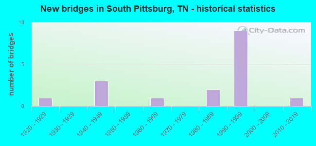
- New bridges - historical statistics
- 11920-1929
- 31940-1949
- 11960-1969
- 21980-1989
- 91990-1999
- 12010-2019


- Bridge Condition - Deck
- 66.7%Good
- 16.7%Satisfactory
- 16.7%Fair

- Bridge Condition - Superstructure
- 16.7%Very good
- 50.0%Good
- 33.3%Fair

- Bridge Condition - Substructure
- 16.7%Very good
- 33.3%Good
- 50.0%Fair

- Bridge Condition - Channel
- 20.0%Very good
- 40.0%Good
- 30.0%Fair
- 10.0%Poor

- Bridge Condition - Culverts
- 14.3%Very good
- 85.7%Good
Find on map >> Show street view
Structure Number: 580A4430001, Location: NEAR STATE LINE (Lat: 34.992669, Lng: -85.726700), Route carried "on" structure: City street 443, Year Built: 1992, Status: Open, Structure Length: 0.82m (2.69ft), Average Daily Traffic: 580 (year 2022), Average Future Daily Traffic: 928 (year 2040), Design Load: HS 20, Features Intersected: POPLAR SPRINGS BRANCH
Minimum Vertical Clearance: 30+ m (98+ ft), Kilometerpoint: 0.785, Lanes on structure: 2, Owner: City or Municipal Highway Agency, Approaching Roadway Width: 7.3m (24.0ft), Skew: 1 degrees, Material/Design: Concrete continuous, Design/Construction: Culvert, Number Of Spans In Main Unit: 2, Length of Maximum Span: 3.7m (12.1ft), Curb-To-Curb Width: 9.8m (32.2ft), Out-to-Out Width: 11.5m (37.7ft)
Condition: Channel: Very good, Culverts: Very good, Operating Rating: 64.8 metric tons, Method Used To Determine Operating Rating: Load Factor (LF), Inventory Rating: 32.4 metric tons, Method Used To Determine Inventory Rating: Load Factor (LF), Structural Evaluation: Equal to present desirable criteria, Deck Geometry: Equal to present minimum criteria, Waterway Adequacy: Better than present minimum criteria, Approach Roadway Alignment: Better than present minimum criteria, Designated Inspection Frequency: Every 24 months, Inspection Date: November 2020, Deck Structure Type: Concrete Cast-file-Place, Wearing Surface/Protective System: Wearing Surface: Monolithic Concrete, Deck Protection: Epoxy Coated Reinforcing
Find on map >> Show street view
Structure Number: 580A4440001, Location: NEAR STATE LINE (Lat: 34.992069, Lng: -85.722361), Route carried "on" structure: City street 444, Year Built: 1940, Year Reconstructed: 1965, Status: Open, Structure Length: 0.76m (2.49ft), Average Daily Traffic: 1,690 (year 2022), Truck Traffic: 2%, Average Future Daily Traffic: 2,704 (year 2040), Design Load: HS 15, Features Intersected: POPLAR SPRINGS BRANCH
Minimum Vertical Clearance: 30+ m (98+ ft), Kilometerpoint: 0.077, Lanes on structure: 2, Owner: City or Municipal Highway Agency, Approaching Roadway Width: 7.3m (24.0ft), Material/Design: Concrete, Design/Construction: Slab, Number Of Spans In Main Unit: 1, Length of Maximum Span: 7.3m (24.0ft), Curb or Sidewalk Widths: Left: 0.0m, Right: 1.5m (4.9ft), Curb-To-Curb Width: 5.5m (18.0ft), Out-to-Out Width: 7.3m (24.0ft)
Condition: Deck: Fair, Superstructure: Fair, Substructure: Fair, Channel: Poor, Operating Rating: 36.0 metric tons, Method Used To Determine Operating Rating: Field evaluation and documented engineering judgment, Inventory Rating: 24.3 metric tons, Method Used To Determine Inventory Rating: Field evaluation and documented engineering judgment, Structural Evaluation: Somewhat better than minimum adequacy, Deck Geometry: High priority of replacement, Waterway Adequacy: Equal to present minimum criteria, Approach Roadway Alignment: Equal to present minimum criteria, Length Of Structure Improvement: 0.76m (2.49ft), Designated Inspection Frequency: Every 24 months, Inspection Date: November 2020, Bridge Improvement Cost: $113,000, Roadway Improvement Cost: $12,000, Total Project Cost: $170,000 ( Estimate for 2020), Deck Structure Type: Concrete Cast-file-Place, Wearing Surface/Protective System: Wearing Surface: Bituminous
Find on map >> Show street view
Structure Number: 580A4470001, Location: NEAR SOUTH PITTSBURG (Lat: 34.997989, Lng: -85.737839), Route carried "on" structure: County highway 447, Year Built: 1940, Status: Open, Structure Length: 0.67m (2.20ft), Average Daily Traffic: 330 (year 2022), Truck Traffic: 2%, Average Future Daily Traffic: 528 (year 2040), Features Intersected: POPLAR SPRING CREEK
Minimum Vertical Clearance: 30+ m (98+ ft), Kilometerpoint: 1.180, Lanes on structure: 2, Owner: City or Municipal Highway Agency, Approaching Roadway Width: 6.7m (22.0ft), Material/Design: Concrete, Design/Construction: Culvert, Number Of Spans In Main Unit: 1, Length of Maximum Span: 6.1m (20.0ft), Curb-To-Curb Width: 6.2m (20.3ft), Out-to-Out Width: 6.8m (22.3ft)
Condition: Channel: Fair, Culverts: Good, Operating Rating: 36.0 metric tons, Method Used To Determine Operating Rating: Field evaluation and documented engineering judgment, Inventory Rating: 24.3 metric tons, Method Used To Determine Inventory Rating: Field evaluation and documented engineering judgment, Structural Evaluation: Equal to present minimum criteria, Deck Geometry: Meets minimum limits, Waterway Adequacy: Better than present minimum criteria, Approach Roadway Alignment: Equal to present desirable criteria, Length Of Structure Improvement: 0.67m (2.20ft), Designated Inspection Frequency: Every 24 months, Inspection Date: November 2020, Bridge Improvement Cost: $60,000, Roadway Improvement Cost: $7,000, Total Project Cost: $91,000 ( Estimate for 2020), Deck Structure Type: Concrete Cast-file-Place, Wearing Surface/Protective System: Wearing Surface: Bituminous
Find on map >> Show street view
Structure Number: 580A4620001, Location: 4.2 MI SW JCT SR27&SR156 (Lat: 34.988969, Lng: -85.771561), Route carried "on" structure: County highway 462, Year Built: 1940, Status: Posted for load, Structure Length: 0.91m (2.99ft), Average Daily Traffic: 40 (year 2022), Truck Traffic: 2%, Average Future Daily Traffic: 64 (year 2041), Design Load: H 15, Features Intersected: REXTON HOLLOW CREEK
Minimum Vertical Clearance: 30+ m (98+ ft), Kilometerpoint: 0.964, Lanes on structure: 1, Owner: County Highway Agency, Approaching Roadway Width: 2.7m (8.9ft), Skew: 1 degrees, Material/Design: Steel, Design/Construction: Stringer/Multi-beam, Number Of Spans In Main Unit: 1, Length of Maximum Span: 8.2m (26.9ft), Curb-To-Curb Width: 4.1m (13.5ft), Out-to-Out Width: 4.3m (14.1ft)
Condition: Deck: Satisfactory, Superstructure: Fair, Substructure: Fair, Channel: Good, Operating Rating: 18.0 metric tons, Method Used To Determine Operating Rating: Load Factor (LF), Inventory Rating: 16.2 metric tons, Method Used To Determine Inventory Rating: Load Factor (LF), Structural Evaluation: Somewhat better than minimum adequacy, Deck Geometry: Somewhat better than minimum adequacy, Waterway Adequacy: Better than present minimum criteria, Approach Roadway Alignment: Equal to present minimum criteria, Bridge Posting: Required (Relationship of Operating Rating to Maximum Legal Load: 0.1 - 9.9% below), Length Of Structure Improvement: 1.58m (5.18ft), Designated Inspection Frequency: Every 24 months, Inspection Date: September 2020, Bridge Improvement Cost: $288,000, Roadway Improvement Cost: $29,000, Total Project Cost: $433,000 ( Estimate for 2021), Deck Structure Type: Corrugated Steel, Wearing Surface/Protective System: Wearing Surface: Bituminous
Find on map >> Show street view
Structure Number: 580Z0020001, Location: SOUTH PITTSBURG (Lat: 35.009939, Lng: -85.699661), Route carried "on" structure: City street 740, Year Built: 1995, Status: Open, Structure Length: 0.67m (2.20ft), Average Daily Traffic: 150 (year 2022), Truck Traffic: 2%, Average Future Daily Traffic: 240 (year 2040), Design Load: HS 20, Features Intersected: BRANCH
Minimum Vertical Clearance: 30+ m (98+ ft), Kilometerpoint: 0.000, Lanes on structure: 2, Owner: City or Municipal Highway Agency, Approaching Roadway Width: 11.0m (36.1ft), Material/Design: Concrete continuous, Design/Construction: Culvert, Number Of Spans In Main Unit: 2, Length of Maximum Span: 3.0m (9.8ft)
Condition: Channel: Good, Culverts: Good, Operating Rating: 68.0 metric tons, Method Used To Determine Operating Rating: Load Factor (LF), Inventory Rating: 32.4 metric tons, Method Used To Determine Inventory Rating: Load Factor (LF), Structural Evaluation: Better than present minimum criteria, Waterway Adequacy: Equal to present desirable criteria, Approach Roadway Alignment: Equal to present desirable criteria, Designated Inspection Frequency: Every 24 months, Inspection Date: November 2020
Find on map >> Show street view
Structure Number: 58SR0270001, Location: IN SOUTH PITTSBURG (Lat: 34.992103, Lng: -85.721147), Route carried "on" structure: City street 1127, Year Built: 1928, Status: Open, Structure Length: 0.70m (2.30ft), Average Daily Traffic: 3,119 (year 2020), Truck Traffic: 3%, Average Future Daily Traffic: 6,528 (year 2040), Design Load: H 15, Features Intersected: POPLAR SPRINGS BRANCH
Minimum Vertical Clearance: 30+ m (98+ ft), Kilometerpoint: 0.724, Lanes on structure: 3, Owner: City or Municipal Highway Agency, Approaching Roadway Width: 12.8m (42.0ft), Material/Design: Concrete continuous, Design/Construction: Culvert, Number Of Spans In Main Unit: 2, Length of Maximum Span: 3.0m (9.8ft), Curb-To-Curb Width: 14.9m (48.9ft), Out-to-Out Width: 15.9m (52.2ft)
Condition: Channel: Good, Culverts: Good, Operating Rating: 32.4 metric tons, Method Used To Determine Operating Rating: Load Factor (LF), Inventory Rating: 19.4 metric tons, Method Used To Determine Inventory Rating: Load Factor (LF), Structural Evaluation: Somewhat better than minimum adequacy, Deck Geometry: Equal to present minimum criteria, Waterway Adequacy: Equal to present minimum criteria, Approach Roadway Alignment: Equal to present desirable criteria, Designated Inspection Frequency: Every 24 months, Inspection Date: September 2020, Deck Structure Type: Concrete Cast-file-Place, Wearing Surface/Protective System: Wearing Surface: Bituminous
Find on map >> Show street view
Structure Number: 58SR0270011, Location: SOUTH PITTSBURG (Lat: 35.016483, Lng: -85.698267), Route carried "on" structure: State highway 156, Year Built: 1995, Status: Open, Structure Length: 7.68m (25.20ft), Average Daily Traffic: 3,788 (year 2020), Truck Traffic: 4%, Average Future Daily Traffic: 5,840 (year 2040), Design Load: HS 20, Features Intersected: LEE HIGHWAY (SR-27)
Minimum Vertical Clearance: 30+ m (98+ ft), Kilometerpoint: 24.253, Lanes on structure: 2, Lanes under structure: 4, Owner: State Highway Agency, Approaching Roadway Width: 13.4m (44.0ft), Skew: 3 degrees, Material/Design: Prestressed concrete continuous, Design/Construction: Stringer/Multi-beam, Number Of Spans In Main Unit: 4, Length of Maximum Span: 24.1m (79.1ft), Curb-To-Curb Width: 18.3m (60.0ft), Out-to-Out Width: 18.9m (62.0ft)
Condition: Deck: Good, Superstructure: Good, Substructure: Good, Operating Rating: 51.3 metric tons, Method Used To Determine Operating Rating: Load Factor (LF), Inventory Rating: 32.4 metric tons, Method Used To Determine Inventory Rating: Load Factor (LF), Structural Evaluation: Better than present minimum criteria, Deck Geometry: Superior to present desirable criteria, Underclear: Equal to present minimum criteria, Approach Roadway Alignment: Equal to present desirable criteria, Designated Inspection Frequency: Every 24 months, Inspection Date: September 2020, Deck Structure Type: Concrete Precast Panels, Wearing Surface/Protective System: Wearing Surface: Monolithic Concrete, Deck Protection: Epoxy Coated Reinforcing
Find on map >> Show street view
Structure Number: 58SR0270013, Location: SOUTH PITTSBURG (Lat: 35.018633, Lng: -85.697633), Route carried "on" structure: US 72, Year Built: 1995, Status: Open, Structure Length: 10.73m (35.20ft), Average Daily Traffic: 9,991 (year 2020), Truck Traffic: 9%, Average Future Daily Traffic: 19,232 (year 2040), Design Load: HS 20, Features Intersected: NFA 1127 & SEQ VAL RR, Facility Carried by Structure: FAP 27
Minimum Vertical Clearance: 30+ m (98+ ft), Kilometerpoint: 4.265, Lanes on structure: 4, Lanes under structure: 3, Base Highway Network: Yes, Owner: State Highway Agency, Approaching Roadway Width: 26.2m (86.0ft), Skew: 14 degrees, Material/Design: Prestressed concrete continuous, Design/Construction: Stringer/Multi-beam, Number Of Spans In Main Unit: 5, Length of Maximum Span: 25.0m (82.0ft), Curb-To-Curb Width: 25.6m (84.0ft), Out-to-Out Width: 26.8m (87.9ft)
Condition: Deck: Good, Superstructure: Good, Substructure: Good, Operating Rating: 56.7 metric tons, Method Used To Determine Operating Rating: Load Factor (LF), Inventory Rating: 32.4 metric tons, Method Used To Determine Inventory Rating: Load Factor (LF), Structural Evaluation: Better than present minimum criteria, Deck Geometry: Superior to present desirable criteria, Underclear: Meets minimum limits, Approach Roadway Alignment: Equal to present desirable criteria, Designated Inspection Frequency: Every 24 months, Inspection Date: August 2020, Deck Structure Type: Concrete Cast-file-Place, Wearing Surface/Protective System: Wearing Surface: Monolithic Concrete, Deck Protection: Epoxy Coated Reinforcing
Find on map >> Show street view
Structure Number: 58SR0270015, Location: SOUTH PITTSBURG (Lat: 34.994867, Lng: -85.706550), Route carried "on" structure: US 72, Year Built: 1995, Status: Open, Structure Length: 1.22m (4.00ft), Average Daily Traffic: 9,991 (year 2020), Truck Traffic: 9%, Average Future Daily Traffic: 19,232 (year 2040), Design Load: HS 20, Features Intersected: POPLAR SPRINGS BRANCH, Facility Carried by Structure: FAP 27
Minimum Vertical Clearance: 30+ m (98+ ft), Kilometerpoint: 1.481, Lanes on structure: 4, Base Highway Network: Yes, Owner: State Highway Agency, Approaching Roadway Width: 24.0m (78.7ft), Skew: 11 degrees, Material/Design: Concrete continuous, Design/Construction: Culvert, Number Of Spans In Main Unit: 2, Length of Maximum Span: 5.7m (18.7ft)
Condition: Channel: Very good, Culverts: Good, Operating Rating: 89.1 metric tons, Method Used To Determine Operating Rating: Load Factor (LF), Inventory Rating: 32.4 metric tons, Method Used To Determine Inventory Rating: Load Factor (LF), Structural Evaluation: Better than present minimum criteria, Waterway Adequacy: Equal to present desirable criteria, Approach Roadway Alignment: Equal to present desirable criteria, Designated Inspection Frequency: Every 24 months, Inspection Date: August 2020
Find on map >> Show street view
Structure Number: 58SR0270023, Location: SOUTH PITTSBURG (Lat: 35.008000, Lng: -85.701500), Route carried "on" structure: US 72, Year Built: 1995, Status: Open, Structure Length: 0.71m (2.33ft), Average Daily Traffic: 9,991 (year 2020), Truck Traffic: 9%, Average Future Daily Traffic: 19,232 (year 2040), Design Load: HS 20, Features Intersected: BRANCH, Facility Carried by Structure: FAP 27
Minimum Vertical Clearance: 30+ m (98+ ft), Kilometerpoint: 3.009, Lanes on structure: 4, Base Highway Network: Yes, Owner: State Highway Agency, Approaching Roadway Width: 23.2m (76.1ft), Skew: 12 degrees, Material/Design: Concrete continuous, Design/Construction: Culvert, Number Of Spans In Main Unit: 2, Length of Maximum Span: 3.4m (11.2ft)
Condition: Channel: Fair, Culverts: Good, Operating Rating: 54.0 metric tons, Method Used To Determine Operating Rating: Field evaluation and documented engineering judgment, Inventory Rating: 32.4 metric tons, Method Used To Determine Inventory Rating: Field evaluation and documented engineering judgment, Structural Evaluation: Better than present minimum criteria, Waterway Adequacy: Equal to present desirable criteria, Approach Roadway Alignment: Equal to present desirable criteria, Length Of Structure Improvement: 0.71m (2.33ft), Designated Inspection Frequency: Every 24 months, Inspection Date: August 2020, Bridge Improvement Cost: $249,000, Roadway Improvement Cost: $25,000, Total Project Cost: $374,000 ( Estimate for 2020)
Find on map >> Show street view
Structure Number: 58SR0270025, Location: SOUTH PITTSBURG (Lat: 35.010267, Lng: -85.700483), Route carried "on" structure: US 72, Year Built: 1995, Status: Open, Structure Length: 0.67m (2.20ft), Average Daily Traffic: 9,991 (year 2020), Truck Traffic: 9%, Average Future Daily Traffic: 19,232 (year 2040), Design Load: HS 20, Features Intersected: BRANCH, Facility Carried by Structure: FAP 27
Minimum Vertical Clearance: 30+ m (98+ ft), Kilometerpoint: 3.283, Lanes on structure: 4, Base Highway Network: Yes, Owner: State Highway Agency, Approaching Roadway Width: 23.2m (76.1ft), Skew: 10 degrees, Material/Design: Concrete continuous, Design/Construction: Culvert, Number Of Spans In Main Unit: 2, Length of Maximum Span: 3.0m (9.8ft)
Condition: Channel: Fair, Culverts: Good, Operating Rating: 54.0 metric tons, Method Used To Determine Operating Rating: Field evaluation and documented engineering judgment, Inventory Rating: 32.4 metric tons, Method Used To Determine Inventory Rating: Field evaluation and documented engineering judgment, Structural Evaluation: Better than present minimum criteria, Waterway Adequacy: Equal to present desirable criteria, Approach Roadway Alignment: Equal to present desirable criteria, Length Of Structure Improvement: 0.67m (2.20ft), Designated Inspection Frequency: Every 24 months, Inspection Date: August 2020, Bridge Improvement Cost: $236,000, Roadway Improvement Cost: $24,000, Total Project Cost: $355,000 ( Estimate for 2020)
Find on map >> Show street view
Structure Number: 58SR1500001, Location: 0.6 MI W JCT SR28 (Lat: 35.085731, Lng: -85.611114), Route carried "on" structure: State highway 150, Year Built: 2018, Status: Open, Structure Length: 1.76m (5.77ft), Average Daily Traffic: 2,909 (year 2020), Truck Traffic: 3%, Average Future Daily Traffic: 6,432 (year 2040), Design Load: HL 93, Features Intersected: PIPELINE
Minimum Vertical Clearance: 30+ m (98+ ft), Kilometerpoint: 0.933, Lanes on structure: 2, Owner: State Highway Agency, Approaching Roadway Width: 13.4m (44.0ft), Skew: 1 degrees, Material/Design: Prestressed concrete, Design/Construction: Stringer/Multi-beam, Number Of Spans In Main Unit: 1, Length of Maximum Span: 16.4m (53.8ft), Curb-To-Curb Width: 13.1m (43.0ft), Out-to-Out Width: 13.8m (45.3ft)
Condition: Deck: Good, Superstructure: Very good, Substructure: Very good, Operating Rating: 44.1 metric tons, Method Used To Determine Operating Rating: Assigned ratings based on Load and Resistance Factor Design (LRFD) reported by rating factor (RF) using HL93 loadings, Inventory Rating: 32.4 metric tons, Method Used To Determine Inventory Rating: Assigned ratings based on Load and Resistance Factor Design (LRFD) reported by rating factor (RF) using HL93 loadings, Structural Evaluation: Equal to present desirable criteria, Deck Geometry: Equal to present minimum criteria, Approach Roadway Alignment: Equal to present desirable criteria, Designated Inspection Frequency: Every 24 months, Inspection Date: September 2020, Deck Structure Type: Concrete Cast-file-Place, Wearing Surface/Protective System: Wearing Surface: Monolithic Concrete, Deck Protection: Epoxy Coated Reinforcing
Find on map >> Show street view
Structure Number: 58SR1560001, Location: 2 MI.FROM I-24 (Lat: 35.015700, Lng: -85.696267), Route carried "on" structure: State highway 156, Year Built: 1981, Status: Open, Structure Length: 46.15m (151.41ft), Average Daily Traffic: 3,788 (year 2020), Truck Traffic: 4%, Average Future Daily Traffic: 6,061 (year 2041), Design Load: HS 20, Features Intersected: TENNESSEE RIVER
Minimum Vertical Clearance: 6.93m (22.74ft), Kilometerpoint: 24.446, Lanes on structure: 2, Owner: State Highway Agency, Approaching Roadway Width: 13.4m (44.0ft), Navigation Control: Yes ( Vertical Clearance: 16.1m (52.8ft), Horizontal Clearance: 224.0m (734.9ft)), Material/Design: Steel, Design/Construction: Arch - Thru, Number Of Spans In Main Unit: 1, Number Of Approach Spans: 5, Length of Maximum Span: 228.6m (750.0ft), Curb-To-Curb Width: 14.6m (47.9ft), Out-to-Out Width: 15.2m (49.9ft)
Condition: Deck: Good, Superstructure: Good, Substructure: Fair, Channel: Good, Operating Rating: 62.1 metric tons, Method Used To Determine Operating Rating: Load Factor (LF), Inventory Rating: 32.4 metric tons, Method Used To Determine Inventory Rating: Load Factor (LF), Structural Evaluation: Somewhat better than minimum adequacy, Deck Geometry: Superior to present desirable criteria, Waterway Adequacy: Better than present minimum criteria, Approach Roadway Alignment: Equal to present desirable criteria, Designated Inspection Frequency: Every 24 months, Critical Feature Inspection Frequency: Every 24 months, Underwater Inspection Frequency: Every 60 months, Inspection Date: May 2021, Critical Feature Inspection Date: September 2020, Underwater Inspection Date: August 2020, Deck Structure Type: Concrete Cast-file-Place, Wearing Surface/Protective System: Wearing Surface: Monolithic Concrete
Find on map >> Show street view
Structure Number: 58SR0270011, Location: SOUTH PITTSBURG (Lat: 35.016483, Lng: -85.698267), Route carried "under" structure: US 72, Year Built: 1995, Structure Length: 0. m, Average Daily Traffic: 9,991 (year 2020), Truck Traffic: 9%, Features Intersected: SR-156 / SR-27, Facility Carried by Structure: FAU 156
Minimum Vertical Clearance: 5.23m (17.16ft), Kilometerpoint: 4.007, Lanes on structure: 2, Lanes under structure: 4, Material/Design: Prestressed concrete continuous, Design/Construction: Stringer/Multi-beam, Length of Maximum Span: 24.1m (79.1ft)
Find on map >> Show street view
Structure Number: 58SR0270013, Location: SOUTH PITTSBURG (Lat: 35.018633, Lng: -85.697633), Route carried "under" structure: Ramp City street 1127, Year Built: 1995, Structure Length: 0. m, Average Daily Traffic: 4,080 (year 2018), Truck Traffic: 2%, Features Intersected: SR-27 / N. CEDAR AVE, Facility Carried by Structure: FAP 27
Minimum Vertical Clearance: 5.66m (18.57ft), Kilometerpoint: 0.243, Lanes on structure: 4, Lanes under structure: 3, Material/Design: Prestressed concrete continuous, Design/Construction: Stringer/Multi-beam, Length of Maximum Span: 25.0m (82.0ft)
Find on map >> Show street view
Structure Number: 58SR0270019, Location: NEAR SOUTH PITTSBURG TENN (Lat: 35.005617, Lng: -85.708950), Route carried "under" structure: City street 1127, Year Built: 1968, Structure Length: 0. m, Average Daily Traffic: 3,119 (year 2020), Truck Traffic: 3%, Features Intersected: PEDESTRIAN WALKWAY, Facility Carried by Structure: PEDESTRIAN WALKWAY
Minimum Vertical Clearance: 30+ m (98+ ft), Kilometerpoint: 2.591, Lanes under structure: 4, Material/Design: Steel, Design/Construction: Stringer/Multi-beam, Length of Maximum Span: 26.2m (86.0ft)
Find on map >> Show street view
Structure Number: 58SR1560001, Location: SR156/JAYCEE DRIVE (Lat: 35.015633, Lng: -85.695808), Route carried "under" structure: City street 744, Year Built: 1981, Structure Length: 0. m, Truck Traffic: 10%, Features Intersected: SR156, Facility Carried by Structure: SR156
Minimum Vertical Clearance: 13.70m (44.95ft), Kilometerpoint: 0.539, Lanes on structure: 20, Lanes under structure: 20, Material/Design: Steel, Design/Construction: Arch - Thru, Length of Maximum Span: 228.6m (750.0ft)