Bridge Statistics for South Riding, Virginia (VA)
Condition, Traffic, Stress, Structural Evaluation, Project Costs
- National Bridge Inventory (NBI) Statistics
- 34Number of bridges
- 187ft / 56.6mTotal length
- $2,463,000Total costs
- 293,015Total average daily traffic
- 9,529Total average daily truck traffic
- 384,519Total future (year 2014) average daily traffic
- National Bridge Inventory (NBI) Registered Bridges for South Riding
- No street view available for this location
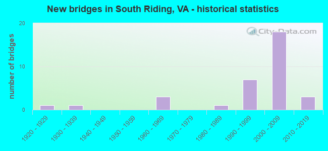
- New bridges - historical statistics
- 11920-1929
- 11930-1939
- 31960-1969
- 11980-1989
- 71990-1999
- 182000-2009
- 32010-2019
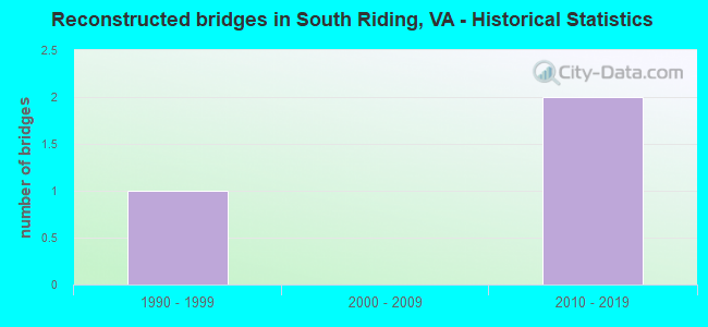
- Reconstructed bridges - Historical Statistics
- 11990-1999
- 02000-2009
- 22010-2019
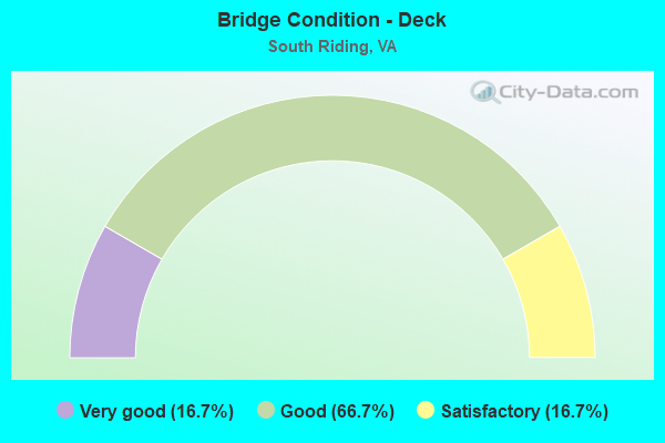
- Bridge Condition - Deck
- 16.7%Very good
- 66.7%Good
- 16.7%Satisfactory
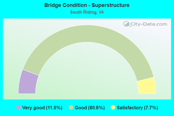
- Bridge Condition - Superstructure
- 11.5%Very good
- 80.8%Good
- 7.7%Satisfactory
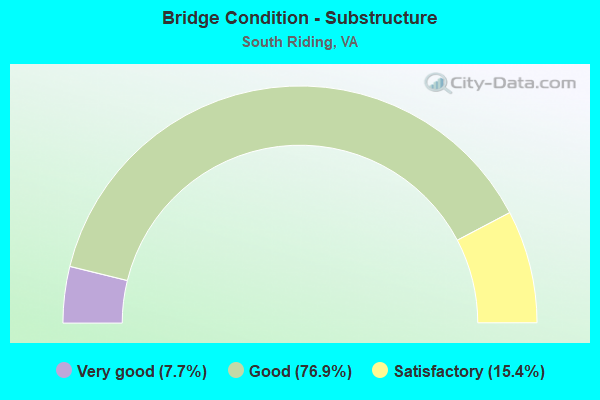
- Bridge Condition - Substructure
- 7.7%Very good
- 76.9%Good
- 15.4%Satisfactory
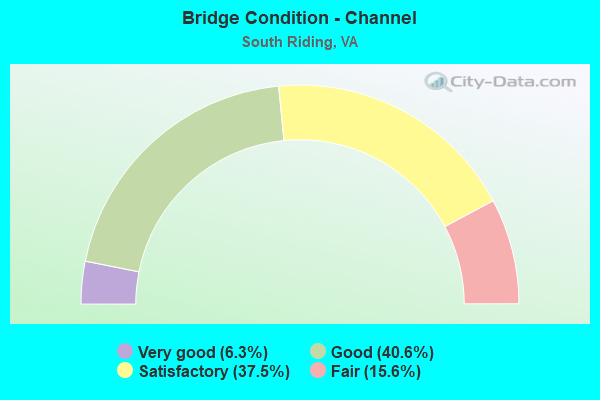
- Bridge Condition - Channel
- 6.3%Very good
- 40.6%Good
- 37.5%Satisfactory
- 15.6%Fair
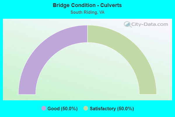
- Bridge Condition - Culverts
- 50.0%Good
- 50.0%Satisfactory
Find on map >> Show street view
Structure Number: 6514, Location: 00.55FR.I66/01.70TO123 (Lat: 38.908922, Lng: -77.187167), Route carried "on" structure: Other road 267, Year Built: 1983, Status: Open, Structure Length: 1.22m (4.00ft), Average Daily Traffic: 54,350 (year 2020), Truck Traffic: 2%, Average Future Daily Traffic: 59,785 (year 2040), Design Load: HS 20, Features Intersected: TRIBUTARY OF PIMMIT RUN, Facility Carried by Structure: DULLES ACC AND TR
Minimum Vertical Clearance: 30+ m (98+ ft), Kilometerpoint: 45.084, Lanes on structure: 4, Base Highway Network: Yes, Owner: State Highway Agency, Approaching Roadway Width: 11.3m (37.1ft), Skew: 5 degrees, Material/Design: Concrete, Design/Construction: Culvert, Number Of Spans In Main Unit: 4, Length of Maximum Span: 3.0m (9.8ft)
Condition: Channel: Good, Culverts: Satisfactory, Operating Rating: 86.2 metric tons, Method Used To Determine Operating Rating: Load Factor (LF), Inventory Rating: 51.7 metric tons, Method Used To Determine Inventory Rating: Load Factor (LF), Structural Evaluation: Equal to present minimum criteria, Waterway Adequacy: Equal to present desirable criteria, Approach Roadway Alignment: Equal to present desirable criteria, Length Of Structure Improvement: 37.92m (124.41ft), Designated Inspection Frequency: Every 24 months, Inspection Date: May 2021, Bridge Improvement Cost: $77,000, Roadway Improvement Cost: $125,000, Total Project Cost: $250,000 ( Estimate for 2015)
Find on map >> Show street view
Structure Number: 6542, Location: 00.62FR689/00.21TO1809 (Lat: 38.929656, Lng: -77.169456), Route carried "on" structure: State highway 309, Year Built: 1920, Year Reconstructed: 2002, Status: Open, Structure Length: 1.22m (4.00ft), Average Daily Traffic: 12,845 (year 2020), Truck Traffic: 2%, Average Future Daily Traffic: 14,130 (year 2040), Design Load: HS 20, Features Intersected: PIMMIT RUN, Facility Carried by Structure: OLD DOMINION DRIVE
Minimum Vertical Clearance: 30+ m (98+ ft), Kilometerpoint: 1.593, Lanes on structure: 2, Owner: State Highway Agency, Approaching Roadway Width: 9.8m (32.2ft), Skew: 8 degrees, Material/Design: Steel, Design/Construction: Stringer/Multi-beam, Number Of Spans In Main Unit: 1, Length of Maximum Span: 12.2m (40.0ft), Curb-To-Curb Width: 9.8m (32.2ft), Out-to-Out Width: 10.4m (34.1ft)
Condition: Deck: Good, Superstructure: Good, Substructure: Good, Channel: Good, Operating Rating: 47.2 metric tons, Method Used To Determine Operating Rating: Load and Resistance Factor (LRFR), Inventory Rating: 36.3 metric tons, Method Used To Determine Inventory Rating: Load and Resistance Factor (LRFR), Structural Evaluation: Better than present minimum criteria, Deck Geometry: Meets minimum limits, Waterway Adequacy: Equal to present desirable criteria, Approach Roadway Alignment: Equal to present minimum criteria, Length Of Structure Improvement: 1.22m (4.00ft), Designated Inspection Frequency: Every 24 months, Inspection Date: October 2020, Bridge Improvement Cost: $265,000, Roadway Improvement Cost: $27,000, Total Project Cost: $300,000, Deck Structure Type: Concrete Cast-file-Place, Wearing Surface/Protective System: Deck Protection: Epoxy Coated Reinforcing
Find on map >> Show street view
Structure Number: 6612, Location: 00.65 123 / 01.94 193 (Lat: 38.930969, Lng: -77.213925), Route carried "on" structure: Interstate 495, Year Built: 1964, Status: Open, Structure Length: 4.27m (14.01ft), Average Daily Traffic: 86,083 (year 2020), Truck Traffic: 5%, Average Future Daily Traffic: 118,920 (year 2040), Design Load: HS 20, Features Intersected: RMP EN OF DUL AIR RD, Facility Carried by Structure: CAPITAL BELTWAY OL
Minimum Vertical Clearance: 30+ m (98+ ft), Kilometerpoint: 18.359, Lanes on structure: 4, Lanes under structure: 3, Base Highway Network: Yes, Owner: State Highway Agency, Approaching Roadway Width: 21.9m (71.9ft), Skew: 2 degrees, Material/Design: Steel, Design/Construction: Stringer/Multi-beam, Number Of Spans In Main Unit: 3, Length of Maximum Span: 15.8m (51.8ft), Curb or Sidewalk Widths: Left: 0.3m (1.0ft), Right: 0.3m (1.0ft), Curb-To-Curb Width: 21.3m (69.9ft), Out-to-Out Width: 22.6m (74.1ft)
Condition: Deck: Satisfactory, Superstructure: Satisfactory, Substructure: Satisfactory, Operating Rating: 59.7 metric tons, Method Used To Determine Operating Rating: Load and Resistance Factor (LRFR), Inventory Rating: 46.0 metric tons, Method Used To Determine Inventory Rating: Load and Resistance Factor (LRFR), Structural Evaluation: Equal to present minimum criteria, Deck Geometry: Better than present minimum criteria, Underclear: High priority of corrective action, Approach Roadway Alignment: Equal to present desirable criteria, Length Of Structure Improvement: 4.27m (14.01ft), Designated Inspection Frequency: Every 24 months, Inspection Date: November 2021, Bridge Improvement Cost: $65,000, Roadway Improvement Cost: $99,000, Total Project Cost: $175,000, Deck Structure Type: Concrete Cast-file-Place, Wearing Surface/Protective System: Wearing Surface: Bituminous, Membrane: Preformed Fabric
Find on map >> Show street view
Structure Number: 12702, Location: 0.0 TO HENRICO & 0.0 NKC (Lat: 37.517406, Lng: -77.209753), Route carried "on" structure: Interstate 64, Year Built: 1966, Year Reconstructed: 2019, Status: Open, Structure Length: 8.02m (26.31ft), Average Daily Traffic: 32,178 (year 2020), Truck Traffic: 9%, Average Future Daily Traffic: 45,049 (year 2040), Design Load: HS 20+Mod, Features Intersected: CHICKAHOMINY RIVER
Minimum Vertical Clearance: 30+ m (98+ ft), Kilometerpoint: 329.250, Lanes on structure: 2, Base Highway Network: Yes, Owner: State Highway Agency, Approaching Roadway Width: 17.7m (58.1ft), Material/Design: Prestressed concrete, Design/Construction: Stringer/Multi-beam, Number Of Spans In Main Unit: 4, Length of Maximum Span: 19.2m (63.0ft), Curb-To-Curb Width: 17.7m (58.1ft), Out-to-Out Width: 18.7m (61.4ft)
Condition: Deck: Good, Superstructure: Good, Substructure: Satisfactory, Channel: Satisfactory, Operating Rating: 84.7 metric tons, Method Used To Determine Operating Rating: Load and Resistance Factor (LRFR), Inventory Rating: 47.6 metric tons, Method Used To Determine Inventory Rating: Load and Resistance Factor (LRFR), Structural Evaluation: Equal to present minimum criteria, Deck Geometry: Superior to present desirable criteria, Waterway Adequacy: Equal to present desirable criteria, Approach Roadway Alignment: Equal to present desirable criteria, Designated Inspection Frequency: Every 24 months, Inspection Date: March 2020, Deck Structure Type: Concrete Cast-file-Place
Find on map >> Show street view
Structure Number: 13257, Location: 0.10 Rt 620; 0.15 Rt 616 (Lat: 36.744519, Lng: -80.315114), Route carried "on" structure: County highway 613, Year Built: 1968, Year Reconstructed: 2010, Status: Open, Structure Length: 0.79m (2.59ft), Average Daily Traffic: 99 (year 2014), Average Future Daily Traffic: 112 (year 2040), Design Load: HS 20+Mod, Features Intersected: North Fork Smith River
Minimum Vertical Clearance: 30+ m (98+ ft), Kilometerpoint: 1.601, Lanes on structure: 2, Base Highway Network: Yes, Owner: State Highway Agency, Approaching Roadway Width: 5.5m (18.0ft), Material/Design: Steel, Design/Construction: Stringer/Multi-beam, Number Of Spans In Main Unit: 1, Length of Maximum Span: 7.9m (25.9ft), Curb or Sidewalk Widths: Left: 0.2m (0.7ft), Right: 0.2m (0.7ft), Curb-To-Curb Width: 5.9m (19.4ft), Out-to-Out Width: 5.9m (19.4ft)
Condition: Deck: Very good, Superstructure: Very good, Substructure: Satisfactory, Channel: Satisfactory, Operating Rating: 81.6 metric tons, Method Used To Determine Operating Rating: Load and Resistance Factor (LRFR), Inventory Rating: 62.6 metric tons, Method Used To Determine Inventory Rating: Load and Resistance Factor (LRFR), Structural Evaluation: Equal to present minimum criteria, Deck Geometry: Meets minimum limits, Waterway Adequacy: Equal to present desirable criteria, Approach Roadway Alignment: Equal to present minimum criteria, Length Of Structure Improvement: 0.79m (2.59ft), Designated Inspection Frequency: Every 24 months, Inspection Date: March 2020, Bridge Improvement Cost: $244,000, Roadway Improvement Cost: $86,000, Total Project Cost: $794,000 ( Estimate for 2016), Deck Structure Type: Wood or Timber, Wearing Surface/Protective System: Wearing Surface: Bituminous, Membrane: Preformed Fabric
Find on map >> Show street view
Structure Number: 14365, Location: 00.68fr234/00.70to Franci (Lat: 38.858950, Lng: -77.555172), Route carried "on" structure: County highway 677, Year Built: 1932, Status: Open, Structure Length: 0.73m (2.40ft), Average Daily Traffic: 485 (year 2016), Average Future Daily Traffic: 718 (year 2040), Design Load: HS 20, Features Intersected: BRANCH OF BULL RUN, Facility Carried by Structure: ALDIE ROAD
Minimum Vertical Clearance: 30+ m (98+ ft), Kilometerpoint: 1.101, Lanes on structure: 2, Owner: State Highway Agency, Approaching Roadway Width: 7.9m (25.9ft), Skew: 3 degrees, Material/Design: Steel, Design/Construction: Culvert, Number Of Spans In Main Unit: 2, Length of Maximum Span: 3.7m (12.1ft)
Condition: Channel: Fair, Culverts: Satisfactory, Operating Rating: 44.5 metric tons, Method Used To Determine Operating Rating: Field evaluation and documented engineering judgment, Inventory Rating: 32.7 metric tons, Method Used To Determine Inventory Rating: Field evaluation and documented engineering judgment, Structural Evaluation: Equal to present minimum criteria, Waterway Adequacy: Somewhat better than minimum adequacy, Approach Roadway Alignment: Better than present minimum criteria, Length Of Structure Improvement: 4.27m (14.01ft), Designated Inspection Frequency: Every 24 months, Inspection Date: May 2021, Bridge Improvement Cost: $66,000, Roadway Improvement Cost: $88,000, Total Project Cost: $175,000 ( Estimate for 2015)
Find on map >> Show street view
Structure Number: 25159, Location: 00.65FR50/00.17TO END (Lat: 38.915986, Lng: -77.511025), Route carried "on" structure: County highway 2201, Year Built: 1997, Status: Open, Structure Length: 1.04m (3.41ft), Average Daily Traffic: 9,147 (year 2020), Average Future Daily Traffic: 10,062 (year 2040), Design Load: HS 20, Features Intersected: TRIB. OF ELKLICK RUN, Facility Carried by Structure: SOUTH RIDING BLVD.
Minimum Vertical Clearance: 30+ m (98+ ft), Kilometerpoint: 0.000, Lanes on structure: 6, Owner: State Highway Agency, Approaching Roadway Width: 23.8m (78.1ft), Skew: 1 degrees, Material/Design: Concrete, Design/Construction: Culvert, Number Of Spans In Main Unit: 3, Length of Maximum Span: 3.4m (11.2ft)
Condition: Channel: Good, Culverts: Good, Operating Rating: 68.9 metric tons, Method Used To Determine Operating Rating: Load Factor (LF), Inventory Rating: 41.7 metric tons, Method Used To Determine Inventory Rating: Load Factor (LF), Structural Evaluation: Better than present minimum criteria, Waterway Adequacy: Better than present minimum criteria, Approach Roadway Alignment: Equal to present desirable criteria, Length Of Structure Improvement: 0.46m (1.51ft), Designated Inspection Frequency: Every 24 months, Inspection Date: January 2021, Bridge Improvement Cost: $50,000, Roadway Improvement Cost: $50,000, Total Project Cost: $110,000
Find on map >> Show street view
Structure Number: 26212, Location: 00.02FR00000/00.04TO00000 (Lat: 38.910000, Lng: -77.506667), Route carried "on" structure: Alternate County highway 1269, Year Built: 1999, Status: Open, Structure Length: 1.01m (3.31ft), Average Daily Traffic: 170 (year 2014), Average Future Daily Traffic: 180 (year 2035), Design Load: HS 20, Features Intersected: TRIB. OF ELKLICK RUN, Facility Carried by Structure: MAPLE CROSS STREET
Minimum Vertical Clearance: 30.18m (99.02ft), Kilometerpoint: 0.451, Lanes on structure: 2, Owner: State Highway Agency, Approaching Roadway Width: 8.2m (26.9ft), Skew: 3 degrees, Material/Design: Concrete, Design/Construction: Culvert, Number Of Spans In Main Unit: 3, Length of Maximum Span: 3.0m (9.8ft), Curb or Sidewalk Widths: Left: 0.4m (1.3ft), Right: 0.0m
Condition: Channel: Satisfactory, Culverts: Good, Operating Rating: 68.9 metric tons, Method Used To Determine Operating Rating: Load Factor (LF), Inventory Rating: 41.7 metric tons, Method Used To Determine Inventory Rating: Load Factor (LF), Structural Evaluation: Better than present minimum criteria, Waterway Adequacy: Better than present minimum criteria, Approach Roadway Alignment: Better than present minimum criteria, Designated Inspection Frequency: Every 24 months, Inspection Date: July 2020
Find on map >> Show street view
Structure Number: 26515, Location: 00.05FR2211/00.05TO2226 (Lat: 38.893194, Lng: -77.496131), Route carried "on" structure: County highway 2210, Year Built: 1999, Status: Open, Structure Length: 1.31m (4.30ft), Average Daily Traffic: 300 (year 2014), Truck Traffic: 1%, Average Future Daily Traffic: 1,000 (year 2035), Design Load: HS 20, Features Intersected: TRIB. ELKLICK RUN, Facility Carried by Structure: MINK MEADOW STREET
Minimum Vertical Clearance: 30.45m (99.90ft), Kilometerpoint: 0.000, Lanes on structure: 2, Owner: State Highway Agency, Approaching Roadway Width: 9.8m (32.2ft), Material/Design: Concrete, Design/Construction: Arch - Deck, Number Of Spans In Main Unit: 2, Length of Maximum Span: 6.1m (20.0ft), Curb or Sidewalk Widths: Left: 1.2m (3.9ft), Right: 1.2m (3.9ft), Curb-To-Curb Width: 9.8m (32.2ft), Out-to-Out Width: 30.5m (100.1ft)
Condition: Superstructure: Good, Substructure: Good, Channel: Good, Operating Rating: 44.5 metric tons, Method Used To Determine Operating Rating: Field evaluation and documented engineering judgment, Inventory Rating: 32.7 metric tons, Method Used To Determine Inventory Rating: Field evaluation and documented engineering judgment, Structural Evaluation: Better than present minimum criteria, Deck Geometry: Better than present minimum criteria, Waterway Adequacy: Better than present minimum criteria, Approach Roadway Alignment: Better than present minimum criteria, Designated Inspection Frequency: Every 24 months, Inspection Date: April 2021
Find on map >> Show street view
Structure Number: 26517, Location: 00.33FR0000/00.23TO621 (Lat: 38.909811, Lng: -77.510678), Route carried "on" structure: County highway 1267, Year Built: 2000, Status: Open, Structure Length: 1.10m (3.61ft), Average Daily Traffic: 670 (year 2019), Average Future Daily Traffic: 757 (year 2040), Design Load: HS 20, Features Intersected: TRIB. ELKLICK RUN, Facility Carried by Structure: GOLF VIEW DRIVE
Minimum Vertical Clearance: 22.86m (75.00ft), Kilometerpoint: 0.000, Lanes on structure: 2, Owner: State Highway Agency, Approaching Roadway Width: 10.4m (34.1ft), Skew: 3 degrees, Material/Design: Concrete, Design/Construction: Arch - Deck, Number Of Spans In Main Unit: 1, Length of Maximum Span: 11.0m (36.1ft), Curb or Sidewalk Widths: Left: 2.1m (6.9ft), Right: 1.2m (3.9ft), Curb-To-Curb Width: 10.4m (34.1ft), Out-to-Out Width: 36.6m (120.1ft)
Condition: Deck: Good, Superstructure: Good, Substructure: Good, Channel: Good, Operating Rating: 89.9 metric tons, Method Used To Determine Operating Rating: Load and Resistance Factor (LRFR), Inventory Rating: 89.8 metric tons, Method Used To Determine Inventory Rating: Load and Resistance Factor (LRFR), Structural Evaluation: Better than present minimum criteria, Deck Geometry: Equal to present minimum criteria, Waterway Adequacy: Better than present minimum criteria, Approach Roadway Alignment: Better than present minimum criteria, Designated Inspection Frequency: Every 24 months, Inspection Date: April 2020
Find on map >> Show street view
Structure Number: 26518, Location: 0.43 FR 0000/0.10 TO 0000 (Lat: 38.906558, Lng: -77.506408), Route carried "on" structure: County highway 1266, Year Built: 2000, Status: Open, Structure Length: 1.55m (5.09ft), Average Daily Traffic: 1,429 (year 2014), Average Future Daily Traffic: 1,615 (year 2040), Design Load: HS 20, Features Intersected: TRIB. ELKLICK RUN, Facility Carried by Structure: PLANTING FIELD DR
Minimum Vertical Clearance: 30+ m (98+ ft), Kilometerpoint: 0.000, Lanes on structure: 2, Owner: State Highway Agency, Approaching Roadway Width: 7.3m (24.0ft), Skew: 2 degrees, Material/Design: Concrete, Design/Construction: Arch - Deck, Number Of Spans In Main Unit: 2, Length of Maximum Span: 7.3m (24.0ft), Curb or Sidewalk Widths: Left: 1.2m (3.9ft), Right: 0.0m, Curb-To-Curb Width: 11.7m (38.4ft), Out-to-Out Width: 32.0m (105.0ft)
Condition: Superstructure: Good, Substructure: Satisfactory, Channel: Satisfactory, Operating Rating: 52.3 metric tons, Method Used To Determine Operating Rating: Load and Resistance Factor (LRFR), Inventory Rating: 41.2 metric tons, Method Used To Determine Inventory Rating: Load and Resistance Factor (LRFR), Structural Evaluation: Equal to present minimum criteria, Deck Geometry: Equal to present minimum criteria, Waterway Adequacy: Better than present minimum criteria, Approach Roadway Alignment: Equal to present desirable criteria, Length Of Structure Improvement: 0.61m (2.00ft), Designated Inspection Frequency: Every 24 months, Inspection Date: March 2021, Bridge Improvement Cost: $100,000, Roadway Improvement Cost: $20,000, Total Project Cost: $125,000
Find on map >> Show street view
Structure Number: 26519, Location: .02 FR Evian /.01 TO Natu (Lat: 38.901392, Lng: -77.497069), Route carried "on" structure: County highway 2237, Year Built: 1996, Status: Open, Structure Length: 0.76m (2.49ft), Average Daily Traffic: 4,365 (year 2019), Average Future Daily Traffic: 4,823 (year 2040), Design Load: HS 20+Mod, Features Intersected: TRIB. ELKLICK RUN, Facility Carried by Structure: EDGEWATER STREET
Minimum Vertical Clearance: 30+ m (98+ ft), Kilometerpoint: 0.000, Lanes on structure: 2, Owner: State Highway Agency, Approaching Roadway Width: 14.6m (47.9ft), Material/Design: Concrete, Design/Construction: Culvert, Number Of Spans In Main Unit: 4, Length of Maximum Span: 1.5m (4.9ft), Curb or Sidewalk Widths: Left: 1.2m (3.9ft), Right: 1.2m (3.9ft), Curb-To-Curb Width: 14.6m (47.9ft), Out-to-Out Width: 15.2m (49.9ft)
Condition: Channel: Satisfactory, Culverts: Satisfactory, Operating Rating: 68.0 metric tons, Method Used To Determine Operating Rating: Load Factor (LF), Inventory Rating: 40.8 metric tons, Method Used To Determine Inventory Rating: Load Factor (LF), Structural Evaluation: Equal to present minimum criteria, Deck Geometry: Superior to present desirable criteria, Waterway Adequacy: Better than present minimum criteria, Approach Roadway Alignment: Equal to present desirable criteria, Length Of Structure Improvement: 12.01m (39.40ft), Designated Inspection Frequency: Every 24 months, Inspection Date: March 2021, Bridge Improvement Cost: $66,000, Roadway Improvement Cost: $79,000, Total Project Cost: $190,000
Find on map >> Show street view
Structure Number: 2714, Location: 00.25FR621/00.25TOPLANT F (Lat: 38.901561, Lng: -77.510289), Route carried "on" structure: County highway 2237, Year Built: 2000, Status: Open, Structure Length: 0.79m (2.59ft), Average Daily Traffic: 3,800 (year 2009), Average Future Daily Traffic: 5,000 (year 2035), Design Load: HS 20, Features Intersected: TRIB. OF ELKLICK RUN, Facility Carried by Structure: EDGEWATER ST.
Minimum Vertical Clearance: 30+ m (98+ ft), Kilometerpoint: 0.000, Lanes on structure: 2, Owner: State Highway Agency, Approaching Roadway Width: 13.4m (44.0ft), Material/Design: Concrete, Design/Construction: Arch - Deck, Number Of Spans In Main Unit: 3, Length of Maximum Span: 2.6m (8.5ft), Curb or Sidewalk Widths: Left: 1.2m (3.9ft), Right: 1.2m (3.9ft), Curb-To-Curb Width: 13.4m (44.0ft), Out-to-Out Width: 38.6m (126.6ft)
Condition: Superstructure: Good, Substructure: Good, Channel: Good, Operating Rating: 44.5 metric tons, Method Used To Determine Operating Rating: Field evaluation and documented engineering judgment, Inventory Rating: 32.7 metric tons, Method Used To Determine Inventory Rating: Field evaluation and documented engineering judgment, Structural Evaluation: Better than present minimum criteria, Deck Geometry: Better than present minimum criteria, Waterway Adequacy: Better than present minimum criteria, Approach Roadway Alignment: Better than present minimum criteria, Designated Inspection Frequency: Every 24 months, Inspection Date: December 2021
Find on map >> Show street view
Structure Number: 27141, Location: 00.42FR621/00.05TOPLANTIN (Lat: 38.900478, Lng: -77.507169), Route carried "on" structure: County highway 2237, Year Built: 2000, Status: Open, Structure Length: 0.94m (3.08ft), Average Daily Traffic: 3,800 (year 2009), Truck Traffic: 1%, Average Future Daily Traffic: 5,000 (year 2035), Design Load: HS 20, Features Intersected: TRIB. OF ELKLICK RUN, Facility Carried by Structure: EDGEWATER DRIVE
Minimum Vertical Clearance: 30.18m (99.02ft), Kilometerpoint: 0.000, Lanes on structure: 2, Owner: State Highway Agency, Approaching Roadway Width: 14.6m (47.9ft), Skew: 2 degrees, Material/Design: Concrete, Design/Construction: Arch - Deck, Number Of Spans In Main Unit: 1, Length of Maximum Span: 9.4m (30.8ft), Curb or Sidewalk Widths: Left: 0.4m (1.3ft), Right: 0.4m (1.3ft), Curb-To-Curb Width: 14.6m (47.9ft), Out-to-Out Width: 42.7m (140.1ft)
Condition: Superstructure: Good, Substructure: Good, Channel: Satisfactory, Operating Rating: 44.5 metric tons, Method Used To Determine Operating Rating: Field evaluation and documented engineering judgment, Inventory Rating: 32.7 metric tons, Method Used To Determine Inventory Rating: Field evaluation and documented engineering judgment, Structural Evaluation: Better than present minimum criteria, Deck Geometry: Superior to present desirable criteria, Waterway Adequacy: Equal to present desirable criteria, Approach Roadway Alignment: Better than present minimum criteria, Designated Inspection Frequency: Every 24 months, Inspection Date: June 2021
Find on map >> Show street view
Structure Number: 27212, Location: 01.20FR50/00.90TO620 (Lat: 38.909364, Lng: -77.514925), Route carried "on" structure: County highway 621, Year Built: 2002, Status: Open, Structure Length: 2.50m (8.20ft), Average Daily Traffic: 2,422 (year 2014), Average Future Daily Traffic: 3,185 (year 2035), Design Load: HS 20+Mod, Features Intersected: ELK LICK RUN, Facility Carried by Structure: ELKLICK ROAD
Minimum Vertical Clearance: 30+ m (98+ ft), Kilometerpoint: 4.965, Lanes on structure: 2, Owner: State Highway Agency, Approaching Roadway Width: 10.1m (33.1ft), Skew: 1 degrees, Material/Design: Concrete, Design/Construction: Slab, Number Of Spans In Main Unit: 3, Length of Maximum Span: 8.2m (26.9ft), Curb or Sidewalk Widths: Left: 1.5m (4.9ft), Right: 0.0m, Curb-To-Curb Width: 8.5m (27.9ft), Out-to-Out Width: 10.8m (35.4ft)
Condition: Deck: Satisfactory, Superstructure: Satisfactory, Substructure: Good, Channel: Satisfactory, Operating Rating: 49.0 metric tons, Method Used To Determine Operating Rating: Load and Resistance Factor (LRFR), Inventory Rating: 38.1 metric tons, Method Used To Determine Inventory Rating: Load and Resistance Factor (LRFR), Structural Evaluation: Equal to present minimum criteria, Deck Geometry: Meets minimum limits, Waterway Adequacy: Equal to present desirable criteria, Approach Roadway Alignment: Better than present minimum criteria, Length Of Structure Improvement: 0.61m (2.00ft), Designated Inspection Frequency: Every 24 months, Inspection Date: June 2020, Bridge Improvement Cost: $10,000, Roadway Improvement Cost: $10,000, Total Project Cost: $25,000 ( Estimate for 2014), Deck Structure Type: Concrete Cast-file-Place, Wearing Surface/Protective System: Deck Protection: Epoxy Coated Reinforcing
Find on map >> Show street view
Structure Number: 27255, Location: 01.30FR609/00.60TO621 (Lat: 38.891689, Lng: -77.506278), Route carried "on" structure: County highway 620, Year Built: 2002, Status: Open, Structure Length: 4.51m (14.80ft), Average Daily Traffic: 10,352 (year 2020), Truck Traffic: 2%, Average Future Daily Traffic: 14,493 (year 2040), Design Load: HS 20, Features Intersected: ELK LICK RUN, Facility Carried by Structure: BRADDOCK ROAD
Minimum Vertical Clearance: 30+ m (98+ ft), Kilometerpoint: 7.665, Lanes on structure: 2, Owner: State Highway Agency, Approaching Roadway Width: 9.8m (32.2ft), Skew: 1 degrees, Material/Design: Concrete, Design/Construction: Arch - Deck, Number Of Spans In Main Unit: 5, Length of Maximum Span: 8.8m (28.9ft), Curb or Sidewalk Widths: Left: 1.5m (4.9ft), Right: 0.0m, Curb-To-Curb Width: 9.8m (32.2ft), Out-to-Out Width: 23.2m (76.1ft)
Condition: Deck: Good, Superstructure: Good, Substructure: Good, Channel: Satisfactory, Operating Rating: 90.6 metric tons, Method Used To Determine Operating Rating: Load and Resistance Factor (LRFR), Inventory Rating: 90.5 metric tons, Method Used To Determine Inventory Rating: Load and Resistance Factor (LRFR), Structural Evaluation: Better than present minimum criteria, Deck Geometry: Meets minimum limits, Waterway Adequacy: Equal to present desirable criteria, Approach Roadway Alignment: Equal to present desirable criteria, Length Of Structure Improvement: 0.30m (0.98ft), Designated Inspection Frequency: Every 24 months, Inspection Date: June 2020, Bridge Improvement Cost: $1,000, Roadway Improvement Cost: $1,000, Total Project Cost: $3,000 ( Estimate for 2014)
Find on map >> Show street view
Structure Number: 27702, Location: 0.2FR2200/1.12TO620 (Lat: 38.914903, Lng: -77.518683), Route carried "on" structure: Alternate County highway 606, Year Built: 1999, Status: Open, Structure Length: 2.65m (8.69ft), Average Daily Traffic: 12,104 (year 2020), Truck Traffic: 2%, Average Future Daily Traffic: 16,946 (year 2040), Design Load: HS 20, Features Intersected: TRIB. OF ELKLICK RUN, Facility Carried by Structure: LOUDOUN CO. PKWY
Minimum Vertical Clearance: 30+ m (98+ ft), Kilometerpoint: 0.000, Lanes on structure: 4, Owner: State Highway Agency, Approaching Roadway Width: 8.8m (28.9ft), Material/Design: Concrete, Design/Construction: Arch - Deck, Number Of Spans In Main Unit: 4, Length of Maximum Span: 6.1m (20.0ft), Curb or Sidewalk Widths: Left: 1.2m (3.9ft), Right: 0.0m, Curb-To-Curb Width: 31.1m (102.0ft), Out-to-Out Width: 70.1m (230.0ft)
Condition: Superstructure: Good, Substructure: Good, Channel: Fair, Operating Rating: 66.6 metric tons, Method Used To Determine Operating Rating: Load Factor (LF), Inventory Rating: 39.9 metric tons, Method Used To Determine Inventory Rating: Load Factor (LF), Structural Evaluation: Better than present minimum criteria, Deck Geometry: Superior to present desirable criteria, Waterway Adequacy: Equal to present desirable criteria, Approach Roadway Alignment: Equal to present desirable criteria, Length Of Structure Improvement: 2.65m (8.69ft), Designated Inspection Frequency: Every 24 months, Inspection Date: August 2021, Bridge Improvement Cost: $20,000, Roadway Improvement Cost: $25,000, Total Project Cost: $70,000
Find on map >> Show street view
Structure Number: 27704, Location: 0.02FRLC.PKWY.& 0.20TO621 (Lat: 38.917389, Lng: -77.517472), Route carried "on" structure: County highway 2200, Year Built: 1999, Status: Open, Structure Length: 0.82m (2.69ft), Average Daily Traffic: 11,842 (year 2020), Average Future Daily Traffic: 13,026 (year 2040), Design Load: HS 20, Features Intersected: TRIB. OF ELKLICK RUN, Facility Carried by Structure: TALL CEDARS PKWY.
Minimum Vertical Clearance: 30+ m (98+ ft), Kilometerpoint: 0.000, Lanes on structure: 6, Owner: State Highway Agency, Approaching Roadway Width: 7.3m (24.0ft), Skew: 20 degrees, Material/Design: Concrete, Design/Construction: Arch - Deck, Number Of Spans In Main Unit: 2, Length of Maximum Span: 4.0m (13.1ft), Curb-To-Curb Width: 18.3m (60.0ft), Out-to-Out Width: 56.4m (185.0ft)
Condition: Superstructure: Very good, Substructure: Good, Channel: Satisfactory, Operating Rating: 69.1 metric tons, Method Used To Determine Operating Rating: Load Factor (LF), Inventory Rating: 41.5 metric tons, Method Used To Determine Inventory Rating: Load Factor (LF), Structural Evaluation: Better than present minimum criteria, Deck Geometry: High priority of replacement, Waterway Adequacy: Equal to present desirable criteria, Approach Roadway Alignment: Equal to present desirable criteria, Length Of Structure Improvement: 0.30m (0.98ft), Designated Inspection Frequency: Every 24 months, Inspection Date: August 2021, Bridge Improvement Cost: $10,000, Roadway Improvement Cost: $20,000, Total Project Cost: $50,000
Find on map >> Show street view
Structure Number: 27705, Location: 0.02FRLC.PKWY & 0.20TO621 (Lat: 38.914189, Lng: -77.517964), Route carried "on" structure: County highway , Year Built: 1999, Status: Open, Structure Length: 2.74m (8.99ft), Average Daily Traffic: 1,699 (year 2014), Average Future Daily Traffic: 1,920 (year 2040), Design Load: HS 20, Features Intersected: TRIB. OF ELKLICK RUN, Facility Carried by Structure: CENTER STREET
Minimum Vertical Clearance: 30+ m (98+ ft), Kilometerpoint: 0.000, Lanes on structure: 2, Owner: State Highway Agency, Approaching Roadway Width: 10.4m (34.1ft), Material/Design: Concrete, Design/Construction: Arch - Deck, Number Of Spans In Main Unit: 3, Length of Maximum Span: 9.1m (29.9ft), Curb or Sidewalk Widths: Left: 1.2m (3.9ft), Right: 0.0m, Curb-To-Curb Width: 10.4m (34.1ft), Out-to-Out Width: 36.6m (120.1ft)
Condition: Superstructure: Good, Substructure: Good, Channel: Good, Operating Rating: 89.8 metric tons, Method Used To Determine Operating Rating: Load Factor (LF), Inventory Rating: 60.3 metric tons, Method Used To Determine Inventory Rating: Load Factor (LF), Structural Evaluation: Better than present minimum criteria, Deck Geometry: Equal to present minimum criteria, Waterway Adequacy: Equal to present desirable criteria, Approach Roadway Alignment: Equal to present desirable criteria, Length Of Structure Improvement: 2.74m (8.99ft), Designated Inspection Frequency: Every 24 months, Inspection Date: August 2021, Bridge Improvement Cost: $20,000, Roadway Improvement Cost: $20,000, Total Project Cost: $50,000 ( Estimate for 2015)
Find on map >> Show street view
Structure Number: 27788, Location: 0.11FR606/0.15TODabner DR (Lat: 38.907139, Lng: -77.523456), Route carried "on" structure: County highway 1248, Year Built: 2003, Status: Open, Structure Length: 1.49m (4.89ft), Average Daily Traffic: 486 (year 2014), Truck Traffic: 2%, Average Future Daily Traffic: 549 (year 2040), Design Load: HS 20, Features Intersected: Branch of Elklick Run, Facility Carried by Structure: Donegal Drive
Minimum Vertical Clearance: 30.18m (99.02ft), Kilometerpoint: 0.000, Lanes on structure: 2, Owner: State Highway Agency, Approaching Roadway Width: 11.0m (36.1ft), Material/Design: Concrete, Design/Construction: Arch - Deck, Number Of Spans In Main Unit: 3, Length of Maximum Span: 6.1m (20.0ft), Curb or Sidewalk Widths: Left: 1.5m (4.9ft), Right: 1.5m (4.9ft), Curb-To-Curb Width: 9.8m (32.2ft), Out-to-Out Width: 30.5m (100.1ft)
Condition: Superstructure: Good, Substructure: Good, Channel: Satisfactory, Operating Rating: 68.9 metric tons, Method Used To Determine Operating Rating: Load Factor (LF), Inventory Rating: 41.7 metric tons, Method Used To Determine Inventory Rating: Load Factor (LF), Structural Evaluation: Better than present minimum criteria, Deck Geometry: Equal to present minimum criteria, Waterway Adequacy: Equal to present desirable criteria, Approach Roadway Alignment: Better than present minimum criteria, Designated Inspection Frequency: Every 24 months, Inspection Date: Febuary 2022
Find on map >> Show street view
Structure Number: 27789, Location: .06FR606/0.3TODabner DR (Lat: 38.906028, Lng: -77.522233), Route carried "on" structure: County highway 1248, Year Built: 2004, Status: Open, Structure Length: 0.64m (2.10ft), Average Daily Traffic: 486 (year 2014), Average Future Daily Traffic: 549 (year 2040), Design Load: HS 20, Features Intersected: Branch of Elklick Run, Facility Carried by Structure: Donegal Drive
Minimum Vertical Clearance: 30+ m (98+ ft), Kilometerpoint: 0.000, Lanes on structure: 2, Owner: State Highway Agency, Approaching Roadway Width: 11.0m (36.1ft), Material/Design: Concrete, Design/Construction: Arch - Deck, Number Of Spans In Main Unit: 1, Length of Maximum Span: 6.1m (20.0ft), Curb or Sidewalk Widths: Left: 1.5m (4.9ft), Right: 1.5m (4.9ft), Curb-To-Curb Width: 9.8m (32.2ft), Out-to-Out Width: 29.9m (98.1ft)
Condition: Superstructure: Good, Substructure: Good, Channel: Very good, Operating Rating: 46.4 metric tons, Method Used To Determine Operating Rating: Load and Resistance Factor (LRFR), Inventory Rating: 36.5 metric tons, Method Used To Determine Inventory Rating: Load and Resistance Factor (LRFR), Structural Evaluation: Better than present minimum criteria, Deck Geometry: Equal to present minimum criteria, Waterway Adequacy: Equal to present desirable criteria, Approach Roadway Alignment: Equal to present desirable criteria, Designated Inspection Frequency: Every 24 months, Inspection Date: Febuary 2022
Find on map >> Show street view
Structure Number: 27862, Location: 0.07fr2200/0.08toCrossfie (Lat: 38.920319, Lng: -77.522869), Route carried "on" structure: Alternate County highway 2657, Year Built: 2004, Status: Open, Structure Length: 1.95m (6.40ft), Average Daily Traffic: 649 (year 2014), Average Future Daily Traffic: 3,500 (year 2014), Design Load: HS 20, Features Intersected: ELKLICK RUN, Facility Carried by Structure: NATIONS DRIVE
Minimum Vertical Clearance: 30.18m (99.02ft), Kilometerpoint: 0.000, Lanes on structure: 2, Owner: State Highway Agency, Approaching Roadway Width: 10.1m (33.1ft), Material/Design: Concrete, Design/Construction: Arch - Deck, Number Of Spans In Main Unit: 3, Length of Maximum Span: 6.1m (20.0ft), Curb or Sidewalk Widths: Left: 1.5m (4.9ft), Right: 1.5m (4.9ft), Curb-To-Curb Width: 9.1m (29.9ft), Out-to-Out Width: 28.3m (92.8ft)
Condition: Superstructure: Good, Substructure: Good, Channel: Satisfactory, Operating Rating: 62.8 metric tons, Method Used To Determine Operating Rating: Load and Resistance Factor (LRFR), Inventory Rating: 47.3 metric tons, Method Used To Determine Inventory Rating: Load and Resistance Factor (LRFR), Structural Evaluation: Better than present minimum criteria, Deck Geometry: Equal to present minimum criteria, Waterway Adequacy: Somewhat better than minimum adequacy, Approach Roadway Alignment: Better than present minimum criteria, Designated Inspection Frequency: Every 24 months, Inspection Date: Febuary 2022
Find on map >> Show street view
Structure Number: 28026, Location: 00.40FRCENT/00.20TODONEGA (Lat: 38.909317, Lng: -77.518822), Route carried "on" structure: County highway 606, Year Built: 2005, Status: Open, Structure Length: 2.14m (7.02ft), Average Daily Traffic: 12,104 (year 2020), Average Future Daily Traffic: 16,946 (year 2040), Design Load: HS 20, Features Intersected: TRIB. OF ELKLICK RUN, Facility Carried by Structure: LOUDOUN CO. PKWY
Minimum Vertical Clearance: 30.18m (99.02ft), Kilometerpoint: 0.000, Lanes on structure: 4, Owner: State Highway Agency, Approaching Roadway Width: 10.7m (35.1ft), Skew: 4 degrees, Material/Design: Concrete, Design/Construction: Arch - Deck, Number Of Spans In Main Unit: 4, Length of Maximum Span: 4.9m (16.1ft), Curb-To-Curb Width: 10.7m (35.1ft), Out-to-Out Width: 88.4m (290.0ft)
Condition: Deck: Good, Superstructure: Good, Substructure: Good, Channel: Good, Operating Rating: 44.5 metric tons, Method Used To Determine Operating Rating: Field evaluation and documented engineering judgment, Inventory Rating: 32.7 metric tons, Method Used To Determine Inventory Rating: Field evaluation and documented engineering judgment, Structural Evaluation: Better than present minimum criteria, Deck Geometry: High priority of replacement, Waterway Adequacy: Better than present minimum criteria, Approach Roadway Alignment: Better than present minimum criteria, Designated Inspection Frequency: Every 24 months, Inspection Date: March 2020
Find on map >> Show street view
Structure Number: 28163, Location: 00.40FRMAND/00.05TOTALL C (Lat: 38.922892, Lng: -77.525411), Route carried "on" structure: Alternate County highway 2671, Year Built: 2005, Status: Open, Structure Length: 1.52m (4.99ft), Average Daily Traffic: 1,200 (year 2014), Truck Traffic: 1%, Average Future Daily Traffic: 3,200 (year 2034), Design Load: HS 20+Mod, Features Intersected: TRIB. OF ELKLICK RUN, Facility Carried by Structure: RIDING CENTER DR.
Minimum Vertical Clearance: 30+ m (98+ ft), Kilometerpoint: 0.000, Lanes on structure: 3, Owner: State Highway Agency, Approaching Roadway Width: 9.1m (29.9ft), Material/Design: Concrete, Design/Construction: Arch - Deck, Number Of Spans In Main Unit: 2, Length of Maximum Span: 7.3m (24.0ft), Curb-To-Curb Width: 8.8m (28.9ft), Out-to-Out Width: 57.9m (190.0ft)
Condition: Deck: Good, Superstructure: Good, Substructure: Good, Channel: Fair, Operating Rating: 77.2 metric tons, Method Used To Determine Operating Rating: Load Factor (LF), Inventory Rating: 48.8 metric tons, Method Used To Determine Inventory Rating: Load Factor (LF), Structural Evaluation: Better than present minimum criteria, Deck Geometry: High priority of replacement, Waterway Adequacy: Equal to present desirable criteria, Approach Roadway Alignment: Equal to present desirable criteria, Designated Inspection Frequency: Every 24 months, Inspection Date: May 2020
Find on map >> Show street view
Structure Number: 28166, Location: 00.20FRNATI/00.01TOSHIPL (Lat: 38.917803, Lng: -77.522000), Route carried "on" structure: County highway 2675, Year Built: 2005, Status: Open, Structure Length: 0.79m (2.59ft), Average Daily Traffic: 1,200 (year 2014), Truck Traffic: 1%, Average Future Daily Traffic: 1,800 (year 2031), Design Load: HS 20, Features Intersected: TRIB.OF ELKLICK RUN, Facility Carried by Structure: CROSSFIELD DR.
Minimum Vertical Clearance: 30+ m (98+ ft), Kilometerpoint: 0.000, Lanes on structure: 2, Owner: State Highway Agency, Approaching Roadway Width: 10.1m (33.1ft), Material/Design: Concrete, Design/Construction: Arch - Deck, Number Of Spans In Main Unit: 2, Length of Maximum Span: 3.7m (12.1ft), Curb or Sidewalk Widths: Left: 0.0m, Right: 1.2m (3.9ft), Curb-To-Curb Width: 10.1m (33.1ft), Out-to-Out Width: 20.7m (67.9ft)
Condition: Deck: Very good, Superstructure: Very good, Substructure: Very good, Channel: Very good, Operating Rating: 89.9 metric tons, Method Used To Determine Operating Rating: Load and Resistance Factor (LRFR), Inventory Rating: 89.8 metric tons, Method Used To Determine Inventory Rating: Load and Resistance Factor (LRFR), Structural Evaluation: Equal to present desirable criteria, Deck Geometry: Somewhat better than minimum adequacy, Waterway Adequacy: Equal to present desirable criteria, Approach Roadway Alignment: Equal to present desirable criteria, Designated Inspection Frequency: Every 24 months, Inspection Date: Febuary 2022
Find on map >> Show street view
Structure Number: 28167, Location: 00.34FR RCD 0.10TO CARRIN (Lat: 38.915408, Lng: -77.531314), Route carried "on" structure: County highway 2681, Year Built: 2005, Status: Open, Structure Length: 2.42m (7.94ft), Average Daily Traffic: 619 (year 2014), Truck Traffic: 1%, Average Future Daily Traffic: 699 (year 2040), Design Load: HS 20, Features Intersected: TRIB OF ELKLICK RUN, Facility Carried by Structure: MANDOLIN STREET
Minimum Vertical Clearance: 30+ m (98+ ft), Kilometerpoint: 0.000, Lanes on structure: 2, Owner: State Highway Agency, Approaching Roadway Width: 22.2m (72.8ft), Material/Design: Concrete, Design/Construction: Arch - Deck, Number Of Spans In Main Unit: 3, Length of Maximum Span: 7.3m (24.0ft), Curb or Sidewalk Widths: Left: 0.0m, Right: 1.2m (3.9ft), Curb-To-Curb Width: 29.9m (98.1ft), Out-to-Out Width: 30.5m (100.1ft)
Condition: Deck: Good, Superstructure: Good, Substructure: Good, Channel: Satisfactory, Operating Rating: 89.9 metric tons, Method Used To Determine Operating Rating: Load and Resistance Factor (LRFR), Inventory Rating: 89.8 metric tons, Method Used To Determine Inventory Rating: Load and Resistance Factor (LRFR), Structural Evaluation: Better than present minimum criteria, Deck Geometry: Superior to present desirable criteria, Waterway Adequacy: Better than present minimum criteria, Approach Roadway Alignment: Superior to present desirable criteria, Designated Inspection Frequency: Every 24 months, Inspection Date: May 2020
Find on map >> Show street view
Structure Number: 28341, Location: 00.50FRONER/00.75TORIDING (Lat: 38.904953, Lng: -77.534203), Route carried "on" structure: County highway 620, Year Built: 2006, Status: Open, Structure Length: 1.28m (4.20ft), Average Daily Traffic: 10,352 (year 2020), Truck Traffic: 2%, Average Future Daily Traffic: 14,493 (year 2040), Design Load: HS 20, Features Intersected: TRIBUTARY OF ELKLICK RUN, Facility Carried by Structure: BRADDOCK RD.
Minimum Vertical Clearance: 30+ m (98+ ft), Kilometerpoint: 0.000, Lanes on structure: 2, Owner: State Highway Agency, Approaching Roadway Width: 7.9m (25.9ft), Skew: 1 degrees, Material/Design: Concrete, Design/Construction: Arch - Deck, Number Of Spans In Main Unit: 2, Length of Maximum Span: 6.1m (20.0ft), Curb-To-Curb Width: 8.5m (27.9ft), Out-to-Out Width: 22.0m (72.2ft)
Condition: Deck: Good, Superstructure: Good, Substructure: Good, Channel: Fair, Operating Rating: 67.1 metric tons, Method Used To Determine Operating Rating: Load Factor (LF), Inventory Rating: 52.6 metric tons, Method Used To Determine Inventory Rating: Load Factor (LF), Structural Evaluation: Better than present minimum criteria, Deck Geometry: High priority of replacement, Waterway Adequacy: Equal to present desirable criteria, Approach Roadway Alignment: Equal to present desirable criteria, Length Of Structure Improvement: 0.03m (0.10ft), Designated Inspection Frequency: Every 24 months, Inspection Date: June 2020, Bridge Improvement Cost: $1,000, Roadway Improvement Cost: $1,000, Total Project Cost: $3,000 ( Estimate for 2014)
Find on map >> Show street view
Structure Number: 28539, Location: 00.05FR PROV/0.08TO PONDE (Lat: 38.926264, Lng: -77.538358), Route carried "on" structure: County highway 2797, Year Built: 2006, Status: Open, Structure Length: 0.67m (2.20ft), Average Daily Traffic: 1,020 (year 2014), Average Future Daily Traffic: 1,153 (year 2040), Design Load: HS 20+Mod, Features Intersected: TRIB. OF ELKLICK RUN, Facility Carried by Structure: BELCOURT CASTLE DR
Minimum Vertical Clearance: 30+ m (98+ ft), Kilometerpoint: 0.000, Lanes on structure: 2, Owner: State Highway Agency, Approaching Roadway Width: 6.7m (22.0ft), Material/Design: Concrete, Design/Construction: Arch - Deck, Number Of Spans In Main Unit: 1, Length of Maximum Span: 6.1m (20.0ft), Curb or Sidewalk Widths: Left: 0.0m, Right: 1.8m (5.9ft), Curb-To-Curb Width: 20.7m (67.9ft), Out-to-Out Width: 21.3m (69.9ft)
Condition: Superstructure: Good, Substructure: Good, Channel: Good, Operating Rating: 69.2 metric tons, Method Used To Determine Operating Rating: Load Factor (LF), Inventory Rating: 38.7 metric tons, Method Used To Determine Inventory Rating: Load Factor (LF), Structural Evaluation: Better than present minimum criteria, Deck Geometry: Superior to present desirable criteria, Waterway Adequacy: Equal to present desirable criteria, Approach Roadway Alignment: Equal to present desirable criteria, Length Of Structure Improvement: 0.67m (2.20ft), Designated Inspection Frequency: Every 24 months, Inspection Date: January 2022, Bridge Improvement Cost: $16,000, Roadway Improvement Cost: $25,000, Total Project Cost: $50,000 ( Estimate for 2016)
Find on map >> Show street view
Structure Number: 28888, Location: 0.30FR 659 & 0.80TO2739 (Lat: 38.870572, Lng: -77.534717), Route carried "on" structure: Alternate County highway 2738, Year Built: 2005, Status: Open, Structure Length: 1.33m (4.36ft), Average Daily Traffic: 1,312 (year 2014), Average Future Daily Traffic: 1,483 (year 2040), Design Load: HS 20, Features Intersected: TRIB OF BULL RUN, Facility Carried by Structure: CEDAR RIDGE BLVD.
Minimum Vertical Clearance: 30+ m (98+ ft), Kilometerpoint: 0.000, Lanes on structure: 2, Owner: State Highway Agency, Approaching Roadway Width: 12.2m (40.0ft), Material/Design: Concrete, Design/Construction: Arch - Deck, Number Of Spans In Main Unit: 2, Length of Maximum Span: 6.1m (20.0ft), Curb or Sidewalk Widths: Left: 0.0m, Right: 1.5m (4.9ft), Curb-To-Curb Width: 20.7m (67.9ft), Out-to-Out Width: 22.0m (72.2ft)
Condition: Superstructure: Good, Substructure: Good, Channel: Good, Operating Rating: 78.4 metric tons, Method Used To Determine Operating Rating: Load Factor (LF), Inventory Rating: 46.6 metric tons, Method Used To Determine Inventory Rating: Load Factor (LF), Structural Evaluation: Better than present minimum criteria, Deck Geometry: Superior to present desirable criteria, Waterway Adequacy: Better than present minimum criteria, Approach Roadway Alignment: Equal to present desirable criteria, Length Of Structure Improvement: 0.30m (0.98ft), Designated Inspection Frequency: Every 24 months, Inspection Date: October 2020, Bridge Improvement Cost: $41,000, Roadway Improvement Cost: $41,000, Total Project Cost: $90,000
Find on map >> Show street view
Structure Number: 29021, Location: 0.30FR EDGE/0.02TO MIDD (Lat: 38.908006, Lng: -77.485108), Route carried "on" structure: County highway 2781, Year Built: 2004, Status: Open, Structure Length: 0.79m (2.59ft), Average Daily Traffic: 1,776 (year 2014), Truck Traffic: 1%, Average Future Daily Traffic: 2,007 (year 2040), Design Load: HS 20, Features Intersected: TRIB OF CUB RUN, Facility Carried by Structure: PARAMOUNT PLACE
Minimum Vertical Clearance: 30.18m (99.02ft), Kilometerpoint: 0.000, Lanes on structure: 2, Owner: State Highway Agency, Approaching Roadway Width: 11.0m (36.1ft), Skew: 3 degrees, Material/Design: Concrete, Design/Construction: Culvert, Number Of Spans In Main Unit: 3, Length of Maximum Span: 2.4m (7.9ft), Curb or Sidewalk Widths: Left: 1.2m (3.9ft), Right: 1.2m (3.9ft)
Condition: Channel: Good, Culverts: Satisfactory, Operating Rating: 89.8 metric tons, Method Used To Determine Operating Rating: Load Factor (LF), Inventory Rating: 69.9 metric tons, Method Used To Determine Inventory Rating: Load Factor (LF), Structural Evaluation: Equal to present minimum criteria, Waterway Adequacy: Equal to present desirable criteria, Approach Roadway Alignment: Equal to present desirable criteria, Designated Inspection Frequency: Every 24 months, Inspection Date: March 2021
Find on map >> Show street view
Structure Number: 29101, Location: 00.10FRPADD/00.10TOEQUINE (Lat: 38.852003, Lng: -77.535853), Route carried "on" structure: County highway 2746, Year Built: 2008, Status: Open, Structure Length: 0.67m (2.20ft), Average Daily Traffic: 72 (year 2014), Average Future Daily Traffic: 81 (year 2040), Design Load: HS 20, Features Intersected: TRIB OF BULL RUN, Facility Carried by Structure: EQUINE PATH WAY
Minimum Vertical Clearance: 30+ m (98+ ft), Kilometerpoint: 0.000, Lanes on structure: 2, Base Highway Network: Yes, Owner: State Highway Agency, Approaching Roadway Width: 6.7m (22.0ft), Skew: 23 degrees, Material/Design: Concrete, Design/Construction: Arch - Deck, Number Of Spans In Main Unit: 1, Length of Maximum Span: 6.1m (20.0ft), Curb or Sidewalk Widths: Left: 0.0m, Right: 1.2m (3.9ft), Curb-To-Curb Width: 6.7m (22.0ft), Out-to-Out Width: 39.3m (128.9ft)
Condition: Superstructure: Good, Substructure: Very good, Channel: Good, Operating Rating: 89.8 metric tons, Method Used To Determine Operating Rating: Load Factor (LF), Inventory Rating: 79.8 metric tons, Method Used To Determine Inventory Rating: Load Factor (LF), Structural Evaluation: Better than present minimum criteria, Deck Geometry: Somewhat better than minimum adequacy, Waterway Adequacy: Equal to present desirable criteria, Approach Roadway Alignment: Equal to present desirable criteria, Designated Inspection Frequency: Every 24 months, Inspection Date: Febuary 2022
Find on map >> Show street view
Structure Number: 29583, Location: .60fr620 1.2 to 2738 (Lat: 38.886711, Lng: -77.513269), Route carried "on" structure: Alternate County highway 621, Year Built: 2011, Status: Open, Structure Length: 1.07m (3.51ft), Average Daily Traffic: 2,833 (year 2020), Truck Traffic: 1%, Average Future Daily Traffic: 3,966 (year 2040), Design Load: HS 20, Features Intersected: Trib. Elklick Run, Facility Carried by Structure: Bull Run P.O. Road
Minimum Vertical Clearance: 30.18m (99.02ft), Kilometerpoint: 0.000, Lanes on structure: 2, Owner: State Highway Agency, Approaching Roadway Width: 7.0m (23.0ft), Skew: 1 degrees, Material/Design: Concrete, Design/Construction: Culvert, Number Of Spans In Main Unit: 3, Length of Maximum Span: 3.0m (9.8ft)
Condition: Channel: Fair, Culverts: Good, Operating Rating: 65.3 metric tons, Method Used To Determine Operating Rating: Load Factor (LF), Inventory Rating: 39.0 metric tons, Method Used To Determine Inventory Rating: Load Factor (LF), Structural Evaluation: Better than present minimum criteria, Waterway Adequacy: Equal to present minimum criteria, Approach Roadway Alignment: Better than present minimum criteria, Length Of Structure Improvement: 0.30m (0.98ft), Designated Inspection Frequency: Every 24 months, Inspection Date: May 2021, Bridge Improvement Cost: $1,000, Roadway Improvement Cost: $1,000, Total Project Cost: $3,000 ( Estimate for 2015)
Find on map >> Show street view
Structure Number: 29596, Location: 00.04FRCAST/00.05TOPINE (Lat: 38.925569, Lng: -77.532431), Route carried "on" structure: County highway 3284, Year Built: 2011, Status: Open, Structure Length: 1.28m (4.20ft), Average Daily Traffic: 500 (year 2011), Average Future Daily Traffic: 3,000 (year 2031), Design Load: HS 20, Features Intersected: Trib. of Elklick Run, Facility Carried by Structure: Avonlea Drive
Minimum Vertical Clearance: 30.45m (99.90ft), Kilometerpoint: 0.000, Lanes on structure: 2, Owner: State Highway Agency, Approaching Roadway Width: 11.0m (36.1ft), Material/Design: Concrete, Design/Construction: Arch - Deck, Number Of Spans In Main Unit: 3, Length of Maximum Span: 3.7m (12.1ft), Curb or Sidewalk Widths: Left: 1.5m (4.9ft), Right: 1.5m (4.9ft), Curb-To-Curb Width: 10.4m (34.1ft), Out-to-Out Width: 26.9m (88.3ft)
Condition: Superstructure: Good, Substructure: Good, Channel: Good, Operating Rating: 81.2 metric tons, Method Used To Determine Operating Rating: Load Factor (LF), Inventory Rating: 38.7 metric tons, Method Used To Determine Inventory Rating: Load Factor (LF), Structural Evaluation: Better than present minimum criteria, Deck Geometry: Equal to present minimum criteria, Approach Roadway Alignment: Equal to present desirable criteria, Designated Inspection Frequency: Every 24 months, Inspection Date: October 2020
Find on map >> Show street view
Structure Number: 29944, Location: 0.90fr234 0.85toCedar R (Lat: 38.856964, Lng: -77.547514), Route carried "on" structure: Alternate County highway 659, Year Built: 2012, Status: Open, Structure Length: 0.62m (2.03ft), Average Daily Traffic: 10,266 (year 2020), Truck Traffic: 2%, Average Future Daily Traffic: 14,372 (year 2040), Design Load: HS 20+Mod, Features Intersected: QUARRY TUNNEL, Facility Carried by Structure: GUM SPRINGS ROAD
Minimum Vertical Clearance: 30.18m (99.02ft), Kilometerpoint: 0.000, Lanes on structure: 2, Lanes under structure: 1, Owner: State Highway Agency, Approaching Roadway Width: 8.2m (26.9ft), Skew: 10 degrees, Material/Design: Steel, Design/Construction: Culvert, Number Of Spans In Main Unit: 1, Length of Maximum Span: 6.2m (20.3ft)
Condition: Culverts: Good, Operating Rating: 47.5 metric tons, Method Used To Determine Operating Rating: Load and Resistance Factor (LRFR), Inventory Rating: 44.5 metric tons, Method Used To Determine Inventory Rating: Load and Resistance Factor (LRFR), Structural Evaluation: Better than present minimum criteria, Underclear: Superior to present desirable criteria, Approach Roadway Alignment: Better than present minimum criteria, Designated Inspection Frequency: Every 24 months, Inspection Date: April 2020