Bridge Statistics for South Vinemont, Alabama (AL)
Condition, Traffic, Stress, Structural Evaluation, Project Costs
- National Bridge Inventory (NBI) Statistics
- 17Number of bridges
- 236ft / 72.4mTotal length
- $21,656,000Total costs
- 148,176Total average daily traffic
- 43,385Total average daily truck traffic
- National Bridge Inventory (NBI) Registered Bridges for South Vinemont
- No street view available for this location
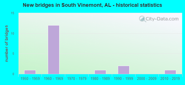
- New bridges - historical statistics
- 11950-1959
- 121960-1969
- 11980-1989
- 21990-1999
- 12010-2019


- Bridge Condition - Deck
- 44.4%Very good
- 44.4%Satisfactory
- 11.1%Fair

- Bridge Condition - Superstructure
- 44.4%Very good
- 33.3%Good
- 22.2%Satisfactory

- Bridge Condition - Substructure
- 33.3%Very good
- 22.2%Good
- 33.3%Satisfactory
- 11.1%Fair

- Bridge Condition - Channel
- 28.6%Very good
- 71.4%Good

- Bridge Condition - Culverts
- 50.0%Good
- 50.0%Satisfactory
Find on map >> Show street view
Structure Number: 4005, Location: 0.2 MI S SR 3 & I 65 (Lat: 34.312300, Lng: -86.899400), Route carried "on" structure: US 31, Year Built: 1951, Status: Open, Structure Length: 0.73m (2.40ft), Average Daily Traffic: 3,970 (year 2019), Truck Traffic: 10%, Average Future Daily Traffic: 5,100 (year 2033), Design Load: H 15, Features Intersected: INDIAN CREEK, Facility Carried by Structure: SR 3
Minimum Vertical Clearance: 7.56m (24.80ft), Kilometerpoint: 542.087, Lanes on structure: 4, Base Highway Network: Yes, Owner: State Highway Agency, Approaching Roadway Width: 15.2m (49.9ft), Skew: 20 degrees, Material/Design: Concrete continuous, Design/Construction: Culvert, Number Of Spans In Main Unit: 2, Length of Maximum Span: 3.7m (12.1ft)
Condition: Channel: Good, Culverts: Good, Operating Rating: 47.2 metric tons, Method Used To Determine Operating Rating: Load Factor (LF), Inventory Rating: 28.3 metric tons, Method Used To Determine Inventory Rating: Load Factor (LF), Structural Evaluation: Better than present minimum criteria, Waterway Adequacy: Equal to present minimum criteria, Approach Roadway Alignment: Equal to present desirable criteria, Length Of Structure Improvement: 1.38m (4.53ft), Designated Inspection Frequency: Every 24 months, Inspection Date: May 2021, Bridge Improvement Cost: $548,000, Roadway Improvement Cost: $55,000, Total Project Cost: $603,000 ( Estimate for 2022)
Find on map >> Show street view
Structure Number: 8166, Location: CR 1223 OVP MP313.1 (Lat: 34.249642, Lng: -86.888825), Route carried "on" structure: County highway 23, Year Built: 1964, Status: Open, Structure Length: 8.08m (26.51ft), Average Daily Traffic: 1,500 (year 2020), Truck Traffic: 1%, Average Future Daily Traffic: 2,100 (year 2040), Design Load: H 20, Features Intersected: I-65
Minimum Vertical Clearance: 30+ m (98+ ft), Kilometerpoint: 0.000, Lanes on structure: 2, Lanes under structure: 4, Owner: State Highway Agency, Approaching Roadway Width: 7.3m (24.0ft), Material/Design: Concrete continuous, Design/Construction: Tee Beam, Number Of Spans In Main Unit: 4, Length of Maximum Span: 22.3m (73.2ft), Curb or Sidewalk Widths: Left: 0.5m (1.6ft), Right: 0.5m (1.6ft), Curb-To-Curb Width: 7.3m (24.0ft), Out-to-Out Width: 8.9m (29.2ft)
Condition: Deck: Satisfactory, Superstructure: Good, Substructure: Good, Operating Rating: 41.3 metric tons, Method Used To Determine Operating Rating: Load Factor (LF), Inventory Rating: 25.6 metric tons, Method Used To Determine Inventory Rating: Load Factor (LF), Structural Evaluation: Equal to present minimum criteria, Deck Geometry: Meets minimum limits, Underclear: Somewhat better than minimum adequacy, Approach Roadway Alignment: Equal to present minimum criteria, Length Of Structure Improvement: 9.08m (29.79ft), Designated Inspection Frequency: Every 24 months, Inspection Date: Febuary 2022, Bridge Improvement Cost: $1,806,000, Roadway Improvement Cost: $181,000, Total Project Cost: $1,987,000 ( Estimate for 2022), Deck Structure Type: Concrete Cast-file-Place
Find on map >> Show street view
Structure Number: 8168, Location: 8 MI N JCT SR 157 * I65 (Lat: 34.308539, Lng: -86.905064), Route carried "on" structure: Interstate 65, Year Built: 1964, Status: Open, Structure Length: 7.01m (23.00ft), Average Daily Traffic: 16,908 (year 2020), Truck Traffic: 32%, Average Future Daily Traffic: 21,671 (year 2040), Design Load: HS 20, Features Intersected: INDIAN CREEK * SER ROAD
Minimum Vertical Clearance: 30+ m (98+ ft), Kilometerpoint: 511.012, Lanes on structure: 2, Lanes under structure: 2, Base Highway Network: Yes, Owner: State Highway Agency, Approaching Roadway Width: 11.0m (36.1ft), Skew: 10 degrees, Material/Design: Concrete continuous, Design/Construction: Tee Beam, Number Of Spans In Main Unit: 4, Length of Maximum Span: 19.2m (63.0ft), Curb or Sidewalk Widths: Left: 0.5m (1.6ft), Right: 0.5m (1.6ft), Curb-To-Curb Width: 8.5m (27.9ft), Out-to-Out Width: 10.1m (33.1ft)
Condition: Deck: Satisfactory, Superstructure: Satisfactory, Substructure: Fair, Channel: Good, Operating Rating: 36.0 metric tons, Method Used To Determine Operating Rating: Load Factor (LF), Inventory Rating: 22.5 metric tons, Method Used To Determine Inventory Rating: Load Factor (LF), Structural Evaluation: Somewhat better than minimum adequacy, Deck Geometry: High priority of corrective action, Underclear: Superior to present desirable criteria, Waterway Adequacy: Equal to present minimum criteria, Approach Roadway Alignment: Better than present minimum criteria, Length Of Structure Improvement: 8.04m (26.38ft), Designated Inspection Frequency: Every 24 months, Inspection Date: Febuary 2022, Bridge Improvement Cost: $1,820,000, Roadway Improvement Cost: $182,000, Total Project Cost: $2,002,000 ( Estimate for 2022), Deck Structure Type: Concrete Cast-file-Place
Find on map >> Show street view
Structure Number: 8169, Location: 8 MI N JCT SR 157 * I-65 (Lat: 34.308389, Lng: -86.905194), Route carried "on" structure: Interstate 65, Year Built: 1964, Status: Open, Structure Length: 7.01m (23.00ft), Average Daily Traffic: 16,908 (year 2020), Truck Traffic: 32%, Average Future Daily Traffic: 21,671 (year 2040), Design Load: HS 20, Features Intersected: INDIAN CREEK * SER ROAD
Minimum Vertical Clearance: 30+ m (98+ ft), Kilometerpoint: 511.012, Lanes on structure: 2, Lanes under structure: 2, Base Highway Network: Yes, Owner: State Highway Agency, Approaching Roadway Width: 11.0m (36.1ft), Skew: 10 degrees, Material/Design: Concrete continuous, Design/Construction: Tee Beam, Number Of Spans In Main Unit: 4, Length of Maximum Span: 19.2m (63.0ft), Curb or Sidewalk Widths: Left: 0.5m (1.6ft), Right: 0.5m (1.6ft), Curb-To-Curb Width: 8.5m (27.9ft), Out-to-Out Width: 10.1m (33.1ft)
Condition: Deck: Fair, Superstructure: Satisfactory, Substructure: Satisfactory, Channel: Very good, Operating Rating: 36.0 metric tons, Method Used To Determine Operating Rating: Load Factor (LF), Inventory Rating: 22.5 metric tons, Method Used To Determine Inventory Rating: Load Factor (LF), Structural Evaluation: Somewhat better than minimum adequacy, Deck Geometry: High priority of corrective action, Underclear: Superior to present desirable criteria, Waterway Adequacy: Equal to present minimum criteria, Approach Roadway Alignment: Better than present minimum criteria, Length Of Structure Improvement: 8.04m (26.38ft), Designated Inspection Frequency: Every 24 months, Inspection Date: Febuary 2022, Bridge Improvement Cost: $1,820,000, Roadway Improvement Cost: $182,000, Total Project Cost: $2,002,000 ( Estimate for 2022), Deck Structure Type: Concrete Cast-file-Place
Find on map >> Show street view
Structure Number: 819, Location: JCT I 65 & SR 3 (Lat: 34.317072, Lng: -86.900625), Route carried "on" structure: Interstate 65, Year Built: 1964, Status: Open, Structure Length: 9.88m (32.41ft), Average Daily Traffic: 15,465 (year 2020), Truck Traffic: 31%, Average Future Daily Traffic: 19,593 (year 2033), Design Load: HS 20, Features Intersected: SR 3
Minimum Vertical Clearance: 30+ m (98+ ft), Kilometerpoint: 512.187, Lanes on structure: 2, Lanes under structure: 4, Base Highway Network: Yes, Owner: State Highway Agency, Approaching Roadway Width: 7.9m (25.9ft), Skew: 14 degrees, Material/Design: Concrete continuous, Design/Construction: Tee Beam, Number Of Spans In Main Unit: 4, Length of Maximum Span: 27.1m (88.9ft), Curb or Sidewalk Widths: Left: 0.5m (1.6ft), Right: 0.5m (1.6ft), Curb-To-Curb Width: 8.5m (27.9ft), Out-to-Out Width: 10.1m (33.1ft)
Condition: Deck: Satisfactory, Superstructure: Good, Substructure: Satisfactory, Operating Rating: 62.2 metric tons, Method Used To Determine Operating Rating: Load Factor (LF), Inventory Rating: 36.7 metric tons, Method Used To Determine Inventory Rating: Load Factor (LF), Structural Evaluation: Equal to present minimum criteria, Deck Geometry: High priority of corrective action, Underclear: Somewhat better than minimum adequacy, Approach Roadway Alignment: Better than present minimum criteria, Length Of Structure Improvement: 10.81m (35.47ft), Designated Inspection Frequency: Every 24 months, Inspection Date: April 2020, Bridge Improvement Cost: $2,446,000, Roadway Improvement Cost: $245,000, Total Project Cost: $2,691,000 ( Estimate for 2022), Deck Structure Type: Concrete Cast-file-Place
Find on map >> Show street view
Structure Number: 8191, Location: JCT I 65 & SR 3 (Lat: 34.316944, Lng: -86.900383), Route carried "on" structure: Interstate 65, Year Built: 1964, Status: Open, Structure Length: 9.88m (32.41ft), Average Daily Traffic: 15,465 (year 2020), Truck Traffic: 31%, Average Future Daily Traffic: 19,593 (year 2033), Design Load: HS 20, Features Intersected: SR 3
Minimum Vertical Clearance: 30+ m (98+ ft), Kilometerpoint: 512.187, Lanes on structure: 2, Lanes under structure: 4, Base Highway Network: Yes, Owner: State Highway Agency, Approaching Roadway Width: 12.2m (40.0ft), Skew: 14 degrees, Material/Design: Concrete continuous, Design/Construction: Tee Beam, Number Of Spans In Main Unit: 4, Length of Maximum Span: 27.1m (88.9ft), Curb or Sidewalk Widths: Left: 0.5m (1.6ft), Right: 0.5m (1.6ft), Curb-To-Curb Width: 8.5m (27.9ft), Out-to-Out Width: 10.1m (33.1ft)
Condition: Deck: Satisfactory, Superstructure: Good, Substructure: Good, Operating Rating: 61.0 metric tons, Method Used To Determine Operating Rating: Load Factor (LF), Inventory Rating: 36.5 metric tons, Method Used To Determine Inventory Rating: Load Factor (LF), Structural Evaluation: Better than present minimum criteria, Deck Geometry: High priority of corrective action, Underclear: Somewhat better than minimum adequacy, Approach Roadway Alignment: Equal to present desirable criteria, Length Of Structure Improvement: 10.81m (35.47ft), Designated Inspection Frequency: Every 24 months, Inspection Date: April 2020, Bridge Improvement Cost: $2,447,000, Roadway Improvement Cost: $245,000, Total Project Cost: $2,692,000 ( Estimate for 2022), Deck Structure Type: Concrete Cast-file-Place
Find on map >> Show street view
Structure Number: 12829, Location: 0.5 MI E SR 31 (Lat: 34.309833, Lng: -86.896478), Route carried "on" structure: County highway 137, Year Built: 1982, Status: Open, Structure Length: 1.04m (3.41ft), Average Daily Traffic: 800 (year 2006), Truck Traffic: 5%, Average Future Daily Traffic: 1,600 (year 2041), Design Load: H 20, Features Intersected: FLINT CREEK RELIEF, Facility Carried by Structure: WILHITE ROAD
Minimum Vertical Clearance: 30+ m (98+ ft), Kilometerpoint: 0.010, Lanes on structure: 2, Owner: County Highway Agency, Approaching Roadway Width: 6.7m (22.0ft), Skew: 3 degrees, Material/Design: Steel, Design/Construction: Culvert, Number Of Spans In Main Unit: 1, Length of Maximum Span: 9.1m (29.9ft)
Condition: Channel: Good, Culverts: Satisfactory, Operating Rating: 47.7 metric tons, Method Used To Determine Operating Rating: Load Factor (LF), Inventory Rating: 41.0 metric tons, Method Used To Determine Inventory Rating: Load Factor (LF), Structural Evaluation: Equal to present minimum criteria, Waterway Adequacy: Better than present minimum criteria, Approach Roadway Alignment: Better than present minimum criteria, Length Of Structure Improvement: 1.71m (5.61ft), Designated Inspection Frequency: Every 24 months, Inspection Date: January 2021, Bridge Improvement Cost: $890,000, Roadway Improvement Cost: $89,000, Total Project Cost: $979,000 ( Estimate for 2022)
Find on map >> Show street view
Structure Number: 15169, Location: CR 1354 vinemont school (Lat: 34.244200, Lng: -86.861494), Route carried "on" structure: County highway 23, Year Built: 1990, Status: Open, Structure Length: 3.81m (12.50ft), Average Daily Traffic: 1,375 (year 1991), Truck Traffic: 10%, Average Future Daily Traffic: 1,400 (year 2033), Design Load: HS 20, Features Intersected: CSX RAILROAD, Facility Carried by Structure: CO. RT. 1354
Minimum Vertical Clearance: 30+ m (98+ ft), Kilometerpoint: 0.000, Lanes on structure: 2, Owner: County Highway Agency, Approaching Roadway Width: 8.5m (27.9ft), Material/Design: Prestressed concrete, Design/Construction: Stringer/Multi-beam, Number Of Spans In Main Unit: 1, Length of Maximum Span: 38.1m (125.0ft), Curb-To-Curb Width: 8.5m (27.9ft), Out-to-Out Width: 9.4m (30.8ft)
Condition: Deck: Very good, Superstructure: Very good, Substructure: Very good, Operating Rating: 88.9 metric tons, Method Used To Determine Operating Rating: Load Factor (LF), Inventory Rating: 39.2 metric tons, Method Used To Determine Inventory Rating: Load Factor (LF), Structural Evaluation: Equal to present desirable criteria, Deck Geometry: Somewhat better than minimum adequacy, Underclear: Superior to present desirable criteria, Approach Roadway Alignment: Better than present minimum criteria, Length Of Structure Improvement: 4.75m (15.58ft), Designated Inspection Frequency: Every 24 months, Inspection Date: March 2021, Bridge Improvement Cost: $976,000, Roadway Improvement Cost: $98,000, Total Project Cost: $1,074,000 ( Estimate for 2022), Deck Structure Type: Concrete Cast-file-Place
Find on map >> Show street view
Structure Number: 1667, Location: CR 1398 (Lat: 34.264964, Lng: -86.872722), Route carried "on" structure: County highway , Year Built: 1995, Status: Open, Structure Length: 14.94m (49.02ft), Average Daily Traffic: 720 (year 1994), Truck Traffic: 2%, Average Future Daily Traffic: 1,200 (year 2028), Design Load: HS 20, Features Intersected: CSX RAILROAD * FLINT CRK, Facility Carried by Structure: CO. RT. 1398 RR
Minimum Vertical Clearance: 30+ m (98+ ft), Kilometerpoint: 0.000, Lanes on structure: 2, Owner: County Highway Agency, Approaching Roadway Width: 14.3m (46.9ft), Skew: 2 degrees, Material/Design: Prestressed concrete, Design/Construction: Stringer/Multi-beam, Number Of Spans In Main Unit: 5, Length of Maximum Span: 39.6m (129.9ft), Curb-To-Curb Width: 12.2m (40.0ft), Out-to-Out Width: 13.0m (42.7ft)
Condition: Deck: Very good, Superstructure: Very good, Substructure: Satisfactory, Channel: Good, Operating Rating: 71.8 metric tons, Method Used To Determine Operating Rating: Load Factor (LF), Inventory Rating: 43.0 metric tons, Method Used To Determine Inventory Rating: Load Factor (LF), Structural Evaluation: Equal to present minimum criteria, Deck Geometry: Equal to present desirable criteria, Waterway Adequacy: Equal to present desirable criteria, Approach Roadway Alignment: Better than present minimum criteria, Length Of Structure Improvement: 15.72m (51.57ft), Designated Inspection Frequency: Every 24 months, Inspection Date: March 2021, Bridge Improvement Cost: $4,526,000, Roadway Improvement Cost: $453,000, Total Project Cost: $4,979,000 ( Estimate for 2022), Deck Structure Type: Concrete Cast-file-Place
Find on map >> Show street view
Structure Number: 18679, Location: CR 1375 (Lat: 34.291250, Lng: -86.857761), Route carried "on" structure: County highway 1375, Year Built: 1963, Year Reconstructed: 2001, Status: Open, Structure Length: 2.68m (8.79ft), Average Daily Traffic: 75 (year 2001), Average Future Daily Traffic: 90 (year 2036), Features Intersected: FLINT CREEK
Minimum Vertical Clearance: 0.00m, Kilometerpoint: 0.008, Lanes on structure: 2, Owner: County Highway Agency, Approaching Roadway Width: 8.5m (27.9ft), Material/Design: Steel, Design/Construction: Stringer/Multi-beam, Number Of Spans In Main Unit: 2, Length of Maximum Span: 13.4m (44.0ft), Curb-To-Curb Width: 8.1m (26.6ft), Out-to-Out Width: 8.7m (28.5ft)
Condition: Deck: Very good, Superstructure: Very good, Substructure: Very good, Channel: Good, Operating Rating: 49.3 metric tons, Method Used To Determine Operating Rating: Load Factor (LF), Inventory Rating: 32.2 metric tons, Method Used To Determine Inventory Rating: Load Factor (LF), Structural Evaluation: Better than present minimum criteria, Deck Geometry: High priority of replacement, Waterway Adequacy: Better than present minimum criteria, Approach Roadway Alignment: Meets minimum limits, Length Of Structure Improvement: 3.60m (11.81ft), Designated Inspection Frequency: Every 24 months, Inspection Date: September 2020, Bridge Improvement Cost: $690,000, Roadway Improvement Cost: $69,000, Total Project Cost: $759,000 ( Estimate for 2022), Deck Structure Type: Concrete Cast-file-Place
Find on map >> Show street view
Structure Number: 20546, Location: 0.6 MI E SR31 (Lat: 34.309939, Lng: -86.893375), Route carried "on" structure: County highway 1137, Year Built: 2014, Status: Open, Structure Length: 7.32m (24.02ft), Average Daily Traffic: 760 (year 2013), Truck Traffic: 10%, Average Future Daily Traffic: 1,297 (year 2040), Design Load: HS 20, Features Intersected: FLINT CREEK, Facility Carried by Structure: WILHITE ROAD
Minimum Vertical Clearance: 30+ m (98+ ft), Kilometerpoint: 0.000, Lanes on structure: 2, Owner: County Highway Agency, Approaching Roadway Width: 8.5m (27.9ft), Material/Design: Prestressed concrete, Design/Construction: Stringer/Multi-beam, Number Of Spans In Main Unit: 4, Length of Maximum Span: 24.4m (80.1ft), Curb or Sidewalk Widths: Left: 0.4m (1.3ft), Right: 0.4m (1.3ft), Curb-To-Curb Width: 8.5m (27.9ft), Out-to-Out Width: 9.4m (30.8ft)
Condition: Deck: Very good, Superstructure: Very good, Substructure: Very good, Channel: Very good, Operating Rating: 67.9 metric tons, Method Used To Determine Operating Rating: Load Factor (LF), Inventory Rating: 40.6 metric tons, Method Used To Determine Inventory Rating: Load Factor (LF), Structural Evaluation: Equal to present desirable criteria, Deck Geometry: Somewhat better than minimum adequacy, Waterway Adequacy: Equal to present desirable criteria, Approach Roadway Alignment: Equal to present desirable criteria, Length Of Structure Improvement: 8.34m (27.36ft), Designated Inspection Frequency: Every 24 months, Inspection Date: March 2020, Bridge Improvement Cost: $1,716,000, Roadway Improvement Cost: $172,000, Total Project Cost: $1,888,000 ( Estimate for 2022), Deck Structure Type: Concrete Cast-file-Place
Find on map >> Show street view
Structure Number: 8166, Location: CR 1223 OVP MP313.1 (Lat: 34.249642, Lng: -86.888825), Route carried "under" structure: Interstate 65, Year Built: 1964, Structure Length: 0. m, Average Daily Traffic: 33,815 (year 2020), Truck Traffic: 32%, Features Intersected: I-65, Facility Carried by Structure: CO RD 1223
Minimum Vertical Clearance: 4.97m (16.31ft), Kilometerpoint: 503.897, Lanes on structure: 2, Lanes under structure: 4, Material/Design: Concrete continuous, Design/Construction: Tee Beam, Length of Maximum Span: 22.3m (73.2ft)
Find on map >> Show street view
Structure Number: 8167, Location: CR 1282 OVP MP 316.164 (Lat: 34.289125, Lng: -86.909775), Route carried "under" structure: Interstate 65, Year Built: 1964, Structure Length: 0. m, Average Daily Traffic: 33,815 (year 2020), Truck Traffic: 32%, Features Intersected: I-65, Facility Carried by Structure: CO RD 1282
Minimum Vertical Clearance: 7.19m (23.59ft), Kilometerpoint: 508.817, Lanes on structure: 2, Lanes under structure: 4, Material/Design: Concrete continuous, Design/Construction: Tee Beam, Length of Maximum Span: 20.7m (67.9ft)
Find on map >> Show street view
Structure Number: 8168, Location: 8 MI N JCT SR 157 * I65 (Lat: 34.308539, Lng: -86.905064), Route carried "under" structure: ServiceOther road , Year Built: 1964, Structure Length: 0. m, Average Daily Traffic: 10 (year 2020), Features Intersected: INDIAN CREEK * SER ROAD, Facility Carried by Structure: I-65
Minimum Vertical Clearance: 10.52m (34.51ft), Kilometerpoint: 268.099, Lanes on structure: 2, Lanes under structure: 2, Material/Design: Concrete continuous, Design/Construction: Tee Beam, Length of Maximum Span: 19.2m (63.0ft)
Find on map >> Show street view
Structure Number: 8169, Location: 8 MI N JCT SR 157 * I-65 (Lat: 34.308389, Lng: -86.905194), Route carried "under" structure: ServiceOther road , Year Built: 1964, Structure Length: 0. m, Average Daily Traffic: 10 (year 2020), Features Intersected: INDIAN CREEK * SER ROAD, Facility Carried by Structure: I-65
Minimum Vertical Clearance: 10.52m (34.51ft), Kilometerpoint: 268.199, Lanes on structure: 2, Lanes under structure: 2, Material/Design: Concrete continuous, Design/Construction: Tee Beam, Length of Maximum Span: 19.2m (63.0ft)
Find on map >> Show street view
Structure Number: 819, Location: JCT I 65 & SR 3 (Lat: 34.317072, Lng: -86.900625), Route carried "under" structure: US 31, Year Built: 1964, Structure Length: 0. m, Average Daily Traffic: 3,290 (year 2020), Truck Traffic: 10%, Features Intersected: SR 3, Facility Carried by Structure: I 65
Minimum Vertical Clearance: 5.26m (17.26ft), Kilometerpoint: 339.020, Lanes on structure: 2, Lanes under structure: 4, Material/Design: Concrete continuous, Design/Construction: Tee Beam, Length of Maximum Span: 27.1m (88.9ft)
Find on map >> Show street view
Structure Number: 8191, Location: JCT I 65 & SR 3 (Lat: 34.316944, Lng: -86.900383), Route carried "under" structure: US 31, Year Built: 1964, Structure Length: 0. m, Average Daily Traffic: 3,290 (year 2020), Truck Traffic: 10%, Features Intersected: SR 3, Facility Carried by Structure: I 65
Minimum Vertical Clearance: 5.21m (17.09ft), Kilometerpoint: 339.020, Lanes on structure: 2, Lanes under structure: 4, Material/Design: Concrete continuous, Design/Construction: Tee Beam, Length of Maximum Span: 27.1m (88.9ft)