Bridge Statistics for South Willard, Utah (UT)
Condition, Traffic, Stress, Structural Evaluation, Project Costs
- National Bridge Inventory (NBI) Statistics
- 14Number of bridges
- 118ft / 36.4mTotal length
- 309,813Total average daily traffic
- 80,132Total average daily truck traffic
- National Bridge Inventory (NBI) Registered Bridges for South Willard
- No street view available for this location
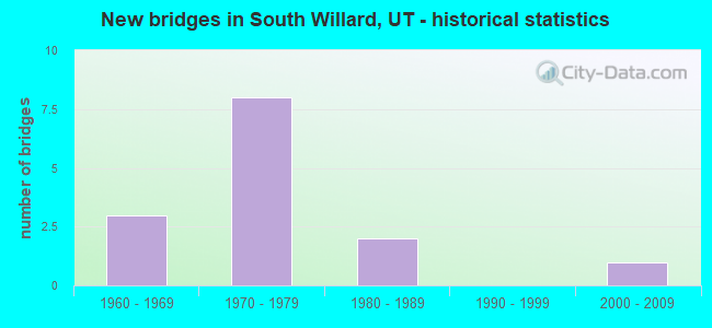
- New bridges - historical statistics
- 31960-1969
- 81970-1979
- 21980-1989
- 12000-2009

- Reconstructed bridges - Historical Statistics
- 11990-1999
- 02000-2009
- 32010-2019


- Bridge Condition - Deck
- 25.0%Good
- 62.5%Satisfactory
- 12.5%Fair

- Bridge Condition - Superstructure
- 12.5%Very good
- 75.0%Good
- 12.5%Fair

- Bridge Condition - Substructure
- 25.0%Good
- 62.5%Satisfactory
- 12.5%Fair
Find on map >> Show street view
Structure Number: 3056D, Location: 2 MILES W.OF HOT SPRINGS (Lat: 41.348586, Lng: -112.064375), Route carried "on" structure: County highway 1084, Year Built: 1960, Status: Posted for load, Structure Length: 2.32m (7.61ft), Average Daily Traffic: 327 (year 2020), Average Future Daily Traffic: 409 (year 2040), Design Load: HL 93, Features Intersected: WILLARD CANAL, Facility Carried by Structure: COUNTY ROAD
Minimum Vertical Clearance: 30+ m (98+ ft), Kilometerpoint: 0.037, Lanes on structure: 2, Owner: County Highway Agency, Approaching Roadway Width: 6.8m (22.3ft), Material/Design: Concrete, Design/Construction: Slab, Number Of Spans In Main Unit: 3, Length of Maximum Span: 7.6m (24.9ft), Curb or Sidewalk Widths: Left: 0.5m (1.6ft), Right: 0.5m (1.6ft), Curb-To-Curb Width: 6.8m (22.3ft), Out-to-Out Width: 7.8m (25.6ft)
Condition: Deck: Good, Superstructure: Good, Substructure: Good, Channel: Good, Operating Rating: 31.8 metric tons, Method Used To Determine Operating Rating: Load Factor (LF) rating reported by rating factor (RF) method using MS18 loading, Inventory Rating: 19.4 metric tons, Method Used To Determine Inventory Rating: Load Factor (LF) rating reported by rating factor (RF) method using MS18 loading, Structural Evaluation: Somewhat better than minimum adequacy, Deck Geometry: Meets minimum limits, Waterway Adequacy: Better than present minimum criteria, Approach Roadway Alignment: Equal to present desirable criteria, Bridge Posting: Required (Relationship of Operating Rating to Maximum Legal Load: 0.1 - 9.9% below), Designated Inspection Frequency: Every 24 months, Inspection Date: November 2021, Deck Structure Type: Concrete Cast-file-Place, Wearing Surface/Protective System: Wearing Surface: Bituminous
Find on map >> Show street view
Structure Number: C 481, Location: 4200 N 2350 W (Lat: 41.340422, Lng: -112.037175), Route carried "on" structure: State highway 126, Year Built: 1968, Year Reconstructed: 1996, Status: Open, Structure Length: 8.69m (28.51ft), Average Daily Traffic: 7,934 (year 2020), Truck Traffic: 29%, Average Future Daily Traffic: 9,918 (year 2040), Design Load: HS 20+Mod, Features Intersected: I-15 (SR-15) NBL AND SBL
Minimum Vertical Clearance: 30+ m (98+ ft), Kilometerpoint: 34.162, Lanes on structure: 3, Lanes under structure: 5, Owner: State Highway Agency, Approaching Roadway Width: 15.8m (51.8ft), Skew: 3 degrees, Material/Design: Steel, Design/Construction: Stringer/Multi-beam, Number Of Spans In Main Unit: 4, Length of Maximum Span: 36.9m (121.1ft), Curb-To-Curb Width: 15.8m (51.8ft), Out-to-Out Width: 16.9m (55.4ft)
Condition: Deck: Fair, Superstructure: Fair, Substructure: Fair, Operating Rating: 37.3 metric tons, Method Used To Determine Operating Rating: Load and Resistance Factor Rating (LRFR) rating reported by rating factor(RF) method using HL-93 loadings, Inventory Rating: 29.8 metric tons, Method Used To Determine Inventory Rating: Load and Resistance Factor Rating (LRFR) rating reported by rating factor(RF) method using HL-93 loadings, Structural Evaluation: Somewhat better than minimum adequacy, Deck Geometry: Better than present minimum criteria, Underclear: Equal to present minimum criteria, Approach Roadway Alignment: Equal to present minimum criteria, Designated Inspection Frequency: Every 24 months, Inspection Date: May 2021, Deck Structure Type: Concrete Cast-file-Place, Wearing Surface/Protective System: Wearing Surface: Bituminous
Find on map >> Show street view
Structure Number: F 446, Location: ADJ. TO HOT SPRINGS INT. (Lat: 41.343611, Lng: -112.034761), Route carried "on" structure: State highway 126, Year Built: 1981, Status: Open, Structure Length: 8.33m (27.33ft), Average Daily Traffic: 7,934 (year 2020), Truck Traffic: 29%, Average Future Daily Traffic: 9,918 (year 2040), Design Load: HS 20+Mod, Features Intersected: US 89 SBL AND UPRR
Minimum Vertical Clearance: 7.32m (24.02ft), Kilometerpoint: 34.573, Lanes on structure: 2, Lanes under structure: 2, Owner: State Highway Agency, Approaching Roadway Width: 13.1m (43.0ft), Skew: 2 degrees, Material/Design: Prestressed concrete continuous, Design/Construction: Stringer/Multi-beam, Number Of Spans In Main Unit: 2, Length of Maximum Span: 42.5m (139.4ft), Curb-To-Curb Width: 13.1m (43.0ft), Out-to-Out Width: 14.1m (46.3ft)
Condition: Deck: Satisfactory, Superstructure: Good, Substructure: Satisfactory, Operating Rating: 37.6 metric tons, Method Used To Determine Operating Rating: Load and Resistance Factor Rating (LRFR) rating reported by rating factor(RF) method using HL-93 loadings, Inventory Rating: 30.1 metric tons, Method Used To Determine Inventory Rating: Load and Resistance Factor Rating (LRFR) rating reported by rating factor(RF) method using HL-93 loadings, Structural Evaluation: Equal to present minimum criteria, Deck Geometry: Somewhat better than minimum adequacy, Underclear: Superior to present desirable criteria, Approach Roadway Alignment: Equal to present minimum criteria, Designated Inspection Frequency: Every 24 months, Inspection Date: May 2021, Deck Structure Type: Concrete Cast-file-Place, Wearing Surface/Protective System: Wearing Surface: Bituminous, Deck Protection: Epoxy Coated Reinforcing
Find on map >> Show street view
Structure Number: F 677, Location: 0.2 MILE NO.of JCT.SR-126 (Lat: 41.347778, Lng: -112.034167), Route carried "on" structure: US 89, Year Built: 2001, Status: Open, Structure Length: 2.64m (8.66ft), Average Daily Traffic: 11,936 (year 2020), Truck Traffic: 16%, Average Future Daily Traffic: 14,920 (year 2040), Design Load: HS 20+Mod, Features Intersected: COLD SPRINGS RESERVOIR
Minimum Vertical Clearance: 30+ m (98+ ft), Kilometerpoint: 681.618, Lanes on structure: 4, Base Highway Network: Yes, Owner: State Highway Agency, Approaching Roadway Width: 20.4m (66.9ft), Material/Design: Prestressed concrete, Design/Construction: Stringer/Multi-beam, Number Of Spans In Main Unit: 1, Length of Maximum Span: 25.6m (84.0ft), Curb-To-Curb Width: 20.4m (66.9ft), Out-to-Out Width: 21.3m (69.9ft)
Condition: Deck: Satisfactory, Superstructure: Very good, Substructure: Satisfactory, Channel: Good, Operating Rating: 58.3 metric tons, Method Used To Determine Operating Rating: Load and Resistance Factor Rating (LRFR) rating reported by rating factor(RF) method using HL-93 loadings, Inventory Rating: 48.6 metric tons, Method Used To Determine Inventory Rating: Load Factor (LF) rating reported by rating factor (RF) method using MS18 loading, Structural Evaluation: Equal to present minimum criteria, Deck Geometry: Superior to present desirable criteria, Waterway Adequacy: Equal to present desirable criteria, Approach Roadway Alignment: Equal to present desirable criteria, Designated Inspection Frequency: Every 24 months, Underwater Inspection Frequency: Every 60 months, Inspection Date: May 2021, Underwater Inspection Date: June 2019, Deck Structure Type: Concrete Cast-file-Place, Wearing Surface/Protective System: Wearing Surface: Monolithic Concrete, Deck Protection: Epoxy Coated Reinforcing
Find on map >> Show street view
Structure Number: 1C 665, Location: 0.8 MI.NO.HOT SPRINGS INT (Lat: 41.351506, Lng: -112.041000), Route carried "on" structure: Interstate 15, Year Built: 1976, Year Reconstructed: 2016, Status: Open, Structure Length: 4.63m (15.19ft), Average Daily Traffic: 55,515 (year 2020), Truck Traffic: 27%, Average Future Daily Traffic: 69,394 (year 2040), Design Load: HS 20+Mod, Features Intersected: HOT SPRINGS LANE AND U
Minimum Vertical Clearance: 30+ m (98+ ft), Kilometerpoint: 567.959, Lanes on structure: 3, Lanes under structure: 2, Base Highway Network: Yes, Owner: State Highway Agency, Approaching Roadway Width: 18.2m (59.7ft), Skew: 1 degrees, Material/Design: Steel continuous, Design/Construction: Stringer/Multi-beam, Number Of Spans In Main Unit: 3, Length of Maximum Span: 32.6m (107.0ft), Curb-To-Curb Width: 18.2m (59.7ft), Out-to-Out Width: 19.0m (62.3ft)
Condition: Deck: Satisfactory, Superstructure: Good, Substructure: Satisfactory, Operating Rating: 35.3 metric tons, Method Used To Determine Operating Rating: Load Factor (LF) rating reported by rating factor (RF) method using MS18 loading, Inventory Rating: 27.9 metric tons, Method Used To Determine Inventory Rating: Load Factor (LF) rating reported by rating factor (RF) method using MS18 loading, Structural Evaluation: Equal to present minimum criteria, Deck Geometry: Better than present minimum criteria, Underclear: Meets minimum limits, Approach Roadway Alignment: Equal to present desirable criteria, Designated Inspection Frequency: Every 24 months, Inspection Date: May 2021, Deck Structure Type: Concrete Cast-file-Place, Wearing Surface/Protective System: Wearing Surface: Epoxy Overlay, Membrane: Epoxy, Deck Protection: Epoxy Coated Reinforcing
Find on map >> Show street view
Structure Number: 1F 169, Location: 1.9 MI.NO.HOT SPRINGS INT (Lat: 41.368675, Lng: -112.042683), Route carried "on" structure: Interstate 15, Year Built: 1976, Year Reconstructed: 2016, Status: Open, Structure Length: 2.58m (8.46ft), Average Daily Traffic: 55,515 (year 2020), Truck Traffic: 27%, Average Future Daily Traffic: 69,394 (year 2040), Design Load: HS 20+Mod, Features Intersected: NERVA LANE (COUNTY ROAD)
Minimum Vertical Clearance: 30+ m (98+ ft), Kilometerpoint: 569.886, Lanes on structure: 3, Lanes under structure: 2, Base Highway Network: Yes, Owner: State Highway Agency, Approaching Roadway Width: 12.3m (40.4ft), Material/Design: Prestressed concrete, Design/Construction: Stringer/Multi-beam, Number Of Spans In Main Unit: 1, Length of Maximum Span: 25.0m (82.0ft), Curb-To-Curb Width: 12.3m (40.4ft), Out-to-Out Width: 19.1m (62.7ft)
Condition: Deck: Satisfactory, Superstructure: Good, Substructure: Satisfactory, Operating Rating: 55.1 metric tons, Method Used To Determine Operating Rating: Load Factor (LF) rating reported by rating factor (RF) method using MS18 loading, Inventory Rating: 29.5 metric tons, Method Used To Determine Inventory Rating: Load Factor (LF) rating reported by rating factor (RF) method using MS18 loading, Structural Evaluation: Equal to present minimum criteria, Deck Geometry: High priority of replacement, Underclear: Meets minimum limits, Approach Roadway Alignment: Equal to present desirable criteria, Designated Inspection Frequency: Every 24 months, Inspection Date: May 2021, Deck Structure Type: Concrete Cast-file-Place, Wearing Surface/Protective System: Wearing Surface: Epoxy Overlay, Membrane: Epoxy
Find on map >> Show street view
Structure Number: 3C 665, Location: 0.8 MI.NO.HOT SPRINGS INT (Lat: 41.351975, Lng: -112.041542), Route carried "on" structure: Interstate 15, Year Built: 1976, Year Reconstructed: 2016, Status: Open, Structure Length: 4.63m (15.19ft), Average Daily Traffic: 55,515 (year 2020), Truck Traffic: 27%, Average Future Daily Traffic: 69,394 (year 2040), Design Load: HS 20+Mod, Features Intersected: HOT SPRINGS LN.& ABD
Minimum Vertical Clearance: 30+ m (98+ ft), Kilometerpoint: 567.828, Lanes on structure: 3, Lanes under structure: 2, Base Highway Network: Yes, Owner: State Highway Agency, Approaching Roadway Width: 18.1m (59.4ft), Skew: 1 degrees, Material/Design: Steel continuous, Design/Construction: Stringer/Multi-beam, Number Of Spans In Main Unit: 3, Length of Maximum Span: 32.6m (107.0ft), Curb-To-Curb Width: 18.1m (59.4ft), Out-to-Out Width: 19.0m (62.3ft)
Condition: Deck: Satisfactory, Superstructure: Good, Substructure: Satisfactory, Operating Rating: 35.3 metric tons, Method Used To Determine Operating Rating: Load and Resistance Factor Rating (LRFR) rating reported by rating factor(RF) method using HL-93 loadings, Inventory Rating: 27.9 metric tons, Method Used To Determine Inventory Rating: Load and Resistance Factor Rating (LRFR) rating reported by rating factor(RF) method using HL-93 loadings, Structural Evaluation: Equal to present minimum criteria, Deck Geometry: Better than present minimum criteria, Underclear: Meets minimum limits, Approach Roadway Alignment: Equal to present desirable criteria, Designated Inspection Frequency: Every 24 months, Inspection Date: May 2021, Deck Structure Type: Concrete Cast-file-Place, Wearing Surface/Protective System: Wearing Surface: Epoxy Overlay, Membrane: Epoxy
Find on map >> Show street view
Structure Number: 3F 169, Location: 1.9 MI.NO.HOT SPRINGS INT (Lat: 41.369061, Lng: -112.043017), Route carried "on" structure: Interstate 15, Year Built: 1976, Status: Open, Structure Length: 2.58m (8.46ft), Average Daily Traffic: 55,515 (year 2020), Truck Traffic: 27%, Average Future Daily Traffic: 69,394 (year 2040), Design Load: HS 20+Mod, Features Intersected: NERVA LANE (COUNTY ROAD)
Minimum Vertical Clearance: 30+ m (98+ ft), Kilometerpoint: 569.743, Lanes on structure: 2, Lanes under structure: 2, Base Highway Network: Yes, Owner: State Highway Agency, Approaching Roadway Width: 12.3m (40.4ft), Material/Design: Prestressed concrete, Design/Construction: Stringer/Multi-beam, Number Of Spans In Main Unit: 1, Length of Maximum Span: 25.0m (82.0ft), Curb-To-Curb Width: 12.3m (40.4ft), Out-to-Out Width: 19.1m (62.7ft)
Condition: Deck: Good, Superstructure: Good, Substructure: Good, Operating Rating: 53.1 metric tons, Method Used To Determine Operating Rating: Load and Resistance Factor Rating (LRFR) rating reported by rating factor(RF) method using HL-93 loadings, Inventory Rating: 24.6 metric tons, Method Used To Determine Inventory Rating: Load Factor (LF) rating reported by rating factor (RF) method using MS18 loading, Structural Evaluation: Equal to present minimum criteria, Deck Geometry: Better than present minimum criteria, Underclear: Meets minimum limits, Approach Roadway Alignment: Equal to present desirable criteria, Designated Inspection Frequency: Every 24 months, Inspection Date: May 2021, Deck Structure Type: Concrete Cast-file-Place, Wearing Surface/Protective System: Wearing Surface: Epoxy Overlay
Find on map >> Show street view
Structure Number: C 481, Location: 4200 N 2350 W (Lat: 41.340422, Lng: -112.037175), Route carried "under" structure: Interstate 15, Year Built: 1968, Structure Length: 0. m, Average Daily Traffic: 47,032 (year 2020), Truck Traffic: 25%, Features Intersected: I-15 (SR-15) NBL AND SBL, Facility Carried by Structure: SR-126
Minimum Vertical Clearance: 5.22m (17.13ft), Kilometerpoint: 566.214, Lanes on structure: 3, Lanes under structure: 5, Material/Design: Steel, Design/Construction: Stringer/Multi-beam, Length of Maximum Span: 36.9m (121.1ft)
Find on map >> Show street view
Structure Number: F 446, Location: ADJ. TO HOT SPRINGS INT. (Lat: 41.343611, Lng: -112.034761), Route carried "under" structure: US 89, Year Built: 1981, Structure Length: 0. m, Average Daily Traffic: 11,936 (year 2020), Truck Traffic: 16%, Features Intersected: US 89 SBL AND UPRR, Facility Carried by Structure: SR-126
Minimum Vertical Clearance: 7.32m (24.02ft), Kilometerpoint: 681.234, Lanes on structure: 2, Lanes under structure: 2, Material/Design: Prestressed concrete continuous, Design/Construction: Stringer/Multi-beam, Length of Maximum Span: 42.5m (139.4ft)
Find on map >> Show street view
Structure Number: 1C 665, Location: 0.8 MI.NO.HOT SPRINGS INT (Lat: 41.351506, Lng: -112.041000), Route carried "under" structure: County highway 1084, Year Built: 1976, Structure Length: 0. m, Average Daily Traffic: 327 (year 2020), Features Intersected: HOT SPRINGS LANE AND U, Facility Carried by Structure: I-15 (SR-15) NBL
Minimum Vertical Clearance: 7.42m (24.34ft), Kilometerpoint: 0.000, Lanes on structure: 3, Lanes under structure: 2, Material/Design: Steel continuous, Design/Construction: Stringer/Multi-beam, Length of Maximum Span: 32.6m (107.0ft)
Find on map >> Show street view
Structure Number: 1F 169, Location: 1.9 MI.NO.HOT SPRINGS INT (Lat: 41.368675, Lng: -112.042683), Route carried "under" structure: County highway , Year Built: 1976, Structure Length: 0. m, Features Intersected: NERVA LANE (COUNTY ROAD), Facility Carried by Structure: I-15 (SR-15) NBL
Minimum Vertical Clearance: 5.00m (16.40ft), Kilometerpoint: 0.000, Lanes on structure: 3, Lanes under structure: 2, Material/Design: Prestressed concrete, Design/Construction: Stringer/Multi-beam, Length of Maximum Span: 25.0m (82.0ft)
Find on map >> Show street view
Structure Number: 3C 665, Location: 0.8 MI.NO.HOT SPRINGS INT (Lat: 41.351975, Lng: -112.041542), Route carried "under" structure: County highway 1084, Year Built: 1976, Structure Length: 0. m, Average Daily Traffic: 327 (year 2020), Features Intersected: HOT SPRINGS LN.& ABD, Facility Carried by Structure: I-15 (SR-15) SBL
Minimum Vertical Clearance: 7.57m (24.84ft), Kilometerpoint: 0.000, Lanes on structure: 3, Lanes under structure: 2, Material/Design: Steel continuous, Design/Construction: Stringer/Multi-beam, Length of Maximum Span: 32.6m (107.0ft)
Find on map >> Show street view
Structure Number: 3F 169, Location: 1.9 MI.NO.HOT SPRINGS INT (Lat: 41.369061, Lng: -112.043017), Route carried "under" structure: County highway , Year Built: 1976, Structure Length: 0. m, Features Intersected: NERVA LANE (COUNTY ROAD), Facility Carried by Structure: I-15 (SR-15) SBL
Minimum Vertical Clearance: 5.26m (17.26ft), Kilometerpoint: 0.000, Lanes on structure: 2, Lanes under structure: 2, Material/Design: Prestressed concrete, Design/Construction: Stringer/Multi-beam, Length of Maximum Span: 25.0m (82.0ft)