Bridge Statistics for Southaven, Mississippi (MS)
Condition, Traffic, Stress, Structural Evaluation, Project Costs
- National Bridge Inventory (NBI) Statistics
- 29Number of bridges
- 335ft / 102mTotal length
- $2,125,999,000Total costs
- 664,700Total average daily traffic
- 87,318Total average daily truck traffic
- National Bridge Inventory (NBI) Registered Bridges for Southaven
- No street view available for this location
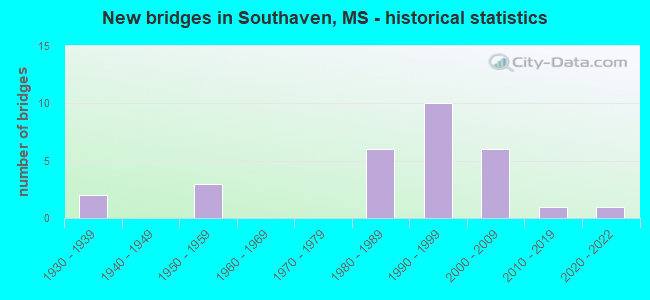
- New bridges - historical statistics
- 21930-1939
- 31950-1959
- 61980-1989
- 101990-1999
- 62000-2009
- 12010-2019
- 12020-2022


- Bridge Condition - Deck
- 33.3%Very good
- 33.3%Good
- 16.7%Satisfactory
- 8.3%Fair
- 8.3%Poor

- Bridge Condition - Superstructure
- 8.3%Excellent
- 50.0%Very good
- 16.7%Good
- 16.7%Fair
- 8.3%Poor

- Bridge Condition - Substructure
- 8.3%Excellent
- 41.7%Very good
- 33.3%Good
- 16.7%Fair

- Bridge Condition - Channel
- 10.5%Very good
- 42.1%Good
- 31.6%Satisfactory
- 15.8%Fair

- Bridge Condition - Culverts
- 7.1%Very good
- 57.1%Good
- 35.7%Satisfactory
Find on map >> Show street view
Structure Number: 11000550172859A, Location: 3.5 MI S SR 302 (Lat: 34.904567, Lng: -89.991328), Route carried "on" structure: Interstate 55, Year Built: 1959, Status: Open, Structure Length: 4.94m (16.21ft), Average Daily Traffic: 29,000 (year 2020), Truck Traffic: 16%, Average Future Daily Traffic: 35,500 (year 2040), Design Load: HS 20, Features Intersected: STAR LANDING ROAD
Minimum Vertical Clearance: 30+ m (98+ ft), Kilometerpoint: 10.112, Lanes on structure: 2, Lanes under structure: 2, Base Highway Network: Yes (Inventory Route: 6, Subroute: 1), Owner: State Highway Agency, Approaching Roadway Width: 8.5m (27.9ft), Material/Design: Concrete continuous, Design/Construction: Box Beam or Girders - Single/Spread, Number Of Spans In Main Unit: 3, Length of Maximum Span: 20.4m (66.9ft), Curb or Sidewalk Widths: Left: 0.5m (1.6ft), Right: 0.5m (1.6ft), Curb-To-Curb Width: 8.5m (27.9ft), Out-to-Out Width: 9.1m (29.9ft)
Condition: Deck: Fair, Superstructure: Fair, Substructure: Good, Operating Rating: 42.4 metric tons, Method Used To Determine Operating Rating: Load Factor (LF), Inventory Rating: 25.4 metric tons, Method Used To Determine Inventory Rating: Load Factor (LF), Structural Evaluation: Somewhat better than minimum adequacy, Deck Geometry: High priority of replacement, Underclear: Equal to present minimum criteria, Approach Roadway Alignment: Equal to present desirable criteria, Length Of Structure Improvement: 6.38m (20.93ft), Designated Inspection Frequency: Every 24 months, Inspection Date: June 2020, Bridge Improvement Cost: $584,000,000, Roadway Improvement Cost: $58,000,000, Total Project Cost: $999,999,000, Deck Structure Type: Concrete Cast-file-Place, Wearing Surface/Protective System: Wearing Surface: Epoxy Overlay
Find on map >> Show street view
Structure Number: 11000550172879A, Location: 2.0 MI S SR 302 (Lat: 34.933903, Lng: -89.994647), Route carried "on" structure: Interstate 55, Year Built: 1996, Status: Open, Structure Length: 7.99m (26.21ft), Average Daily Traffic: 29,000 (year 2020), Truck Traffic: 16%, Average Future Daily Traffic: 35,500 (year 2040), Design Load: HS 20, Features Intersected: CHURCH ROAD
Minimum Vertical Clearance: 30+ m (98+ ft), Kilometerpoint: 6.836, Lanes on structure: 2, Lanes under structure: 2, Base Highway Network: Yes (Inventory Route: 6, Subroute: 1), Owner: State Highway Agency, Approaching Roadway Width: 18.3m (60.0ft), Material/Design: Prestressed concrete continuous, Design/Construction: Stringer/Multi-beam, Number Of Spans In Main Unit: 3, Length of Maximum Span: 33.5m (109.9ft), Curb-To-Curb Width: 18.3m (60.0ft), Out-to-Out Width: 19.1m (62.7ft)
Condition: Deck: Good, Superstructure: Very good, Substructure: Good, Operating Rating: 74.1 metric tons, Method Used To Determine Operating Rating: Load Factor (LF), Inventory Rating: 37.1 metric tons, Method Used To Determine Inventory Rating: Load Factor (LF), Structural Evaluation: Better than present minimum criteria, Deck Geometry: Superior to present desirable criteria, Underclear: Superior to present desirable criteria, Approach Roadway Alignment: Equal to present desirable criteria, Designated Inspection Frequency: Every 24 months, Inspection Date: June 2020, Deck Structure Type: Concrete Cast-file-Place
Find on map >> Show street view
Structure Number: 11000550172879B, Location: 2.0 MI S SR 302 (Lat: 34.933206, Lng: -89.994253), Route carried "on" structure: Interstate 55, Year Built: 1996, Status: Open, Structure Length: 7.99m (26.21ft), Average Daily Traffic: 29,000 (year 2020), Truck Traffic: 16%, Average Future Daily Traffic: 35,500 (year 2040), Design Load: HS 20, Features Intersected: CHURCH ROAD
Minimum Vertical Clearance: 30+ m (98+ ft), Kilometerpoint: 29.174, Lanes on structure: 2, Lanes under structure: 2, Base Highway Network: Yes (Inventory Route: 6, Subroute: 2), Owner: State Highway Agency, Approaching Roadway Width: 18.3m (60.0ft), Material/Design: Prestressed concrete continuous, Design/Construction: Stringer/Multi-beam, Number Of Spans In Main Unit: 3, Length of Maximum Span: 33.5m (109.9ft), Curb-To-Curb Width: 18.3m (60.0ft), Out-to-Out Width: 19.1m (62.7ft)
Condition: Deck: Good, Superstructure: Very good, Substructure: Good, Operating Rating: 74.1 metric tons, Method Used To Determine Operating Rating: Load Factor (LF), Inventory Rating: 37.1 metric tons, Method Used To Determine Inventory Rating: Load Factor (LF), Structural Evaluation: Better than present minimum criteria, Deck Geometry: Superior to present desirable criteria, Underclear: Superior to present desirable criteria, Approach Roadway Alignment: Equal to present desirable criteria, Designated Inspection Frequency: Every 24 months, Inspection Date: May 2020, Deck Structure Type: Concrete Cast-file-Place
Find on map >> Show street view
Structure Number: 11000550172908, Location: 1.5 MI S TENN ST LINE (Lat: 34.973325, Lng: -90.000878), Route carried "on" structure: Interstate 55, Year Built: 1958, Status: Open, Structure Length: 1.58m (5.18ft), Average Daily Traffic: 80,000 (year 2020), Truck Traffic: 13%, Average Future Daily Traffic: 98,000 (year 2040), Design Load: HS 20, Features Intersected: ROCKY CREEK
Minimum Vertical Clearance: 30+ m (98+ ft), Kilometerpoint: 33.669, Lanes on structure: 10, Base Highway Network: Yes (Inventory Route: 6, Subroute: 2), Owner: State Highway Agency, Approaching Roadway Width: 39.0m (128.0ft), Skew: 30 degrees, Material/Design: Concrete, Design/Construction: Culvert, Number Of Spans In Main Unit: 2, Length of Maximum Span: 7.3m (24.0ft)
Condition: Channel: Satisfactory, Culverts: Good, Inventory Rating: 81.0 metric tons, Method Used To Determine Inventory Rating: Load Factor (LF), Structural Evaluation: Better than present minimum criteria, Waterway Adequacy: Equal to present minimum criteria, Approach Roadway Alignment: Equal to present desirable criteria, Designated Inspection Frequency: Every 24 months, Inspection Date: June 2020
Find on map >> Show street view
Structure Number: 11000550172911A, Location: 1.2 MI S TENN ST LINE (Lat: 34.977622, Lng: -90.001767), Route carried "on" structure: Interstate 55, Year Built: 2007, Status: Open, Structure Length: 6.11m (20.05ft), Average Daily Traffic: 40,000 (year 2020), Truck Traffic: 13%, Average Future Daily Traffic: 49,000 (year 2040), Design Load: HS 20, Features Intersected: RASCOE ROAD
Minimum Vertical Clearance: 30+ m (98+ ft), Kilometerpoint: 1.941, Lanes on structure: 5, Lanes under structure: 5, Base Highway Network: Yes (Inventory Route: 6, Subroute: 1), Owner: State Highway Agency, Approaching Roadway Width: 25.6m (84.0ft), Material/Design: Prestressed concrete continuous, Design/Construction: Stringer/Multi-beam, Number Of Spans In Main Unit: 3, Length of Maximum Span: 26.2m (86.0ft), Curb-To-Curb Width: 25.6m (84.0ft), Out-to-Out Width: 26.5m (86.9ft)
Condition: Deck: Very good, Superstructure: Very good, Substructure: Very good, Operating Rating: 57.8 metric tons, Method Used To Determine Operating Rating: Load Factor (LF), Inventory Rating: 34.6 metric tons, Method Used To Determine Inventory Rating: Load Factor (LF), Structural Evaluation: Equal to present desirable criteria, Deck Geometry: Better than present minimum criteria, Underclear: Equal to present desirable criteria, Approach Roadway Alignment: Equal to present desirable criteria, Designated Inspection Frequency: Every 24 months, Inspection Date: June 2021, Deck Structure Type: Concrete Cast-file-Place
Find on map >> Show street view
Structure Number: 11000550172911B, Location: 1.2 MI S TENN ST LINE (Lat: 34.977122, Lng: -90.001403), Route carried "on" structure: Interstate 55, Year Built: 2007, Status: Open, Structure Length: 6.11m (20.05ft), Average Daily Traffic: 40,000 (year 2020), Truck Traffic: 13%, Average Future Daily Traffic: 49,000 (year 2040), Design Load: HS 20, Features Intersected: RASCOE ROAD
Minimum Vertical Clearance: 30+ m (98+ ft), Kilometerpoint: 34.094, Lanes on structure: 5, Lanes under structure: 5, Base Highway Network: Yes (Inventory Route: 6, Subroute: 2), Owner: State Highway Agency, Approaching Roadway Width: 25.6m (84.0ft), Material/Design: Prestressed concrete continuous, Design/Construction: Stringer/Multi-beam, Number Of Spans In Main Unit: 3, Length of Maximum Span: 26.2m (86.0ft), Curb-To-Curb Width: 25.6m (84.0ft), Out-to-Out Width: 26.5m (86.9ft)
Condition: Deck: Very good, Superstructure: Very good, Substructure: Very good, Operating Rating: 57.8 metric tons, Method Used To Determine Operating Rating: Load Factor (LF), Inventory Rating: 34.6 metric tons, Method Used To Determine Inventory Rating: Load Factor (LF), Structural Evaluation: Equal to present desirable criteria, Deck Geometry: Better than present minimum criteria, Underclear: Equal to present desirable criteria, Approach Roadway Alignment: Equal to present desirable criteria, Designated Inspection Frequency: Every 24 months, Inspection Date: June 2021, Deck Structure Type: Concrete Cast-file-Place
Find on map >> Show street view
Structure Number: 11000550172921, Location: 0.2 MI S TENN ST LINE (Lat: 34.991422, Lng: -90.002172), Route carried "on" structure: Interstate 55, Year Built: 2007, Status: Open, Structure Length: 9.99m (32.78ft), Average Daily Traffic: 77,000 (year 2020), Truck Traffic: 10%, Average Future Daily Traffic: 94,000 (year 2040), Design Load: HS 20, Features Intersected: STATE LINE ROAD
Minimum Vertical Clearance: 30+ m (98+ ft), Kilometerpoint: 35.682, Lanes on structure: 8, Lanes under structure: 10, Base Highway Network: Yes (Inventory Route: 6, Subroute: 2), Owner: State Highway Agency, Approaching Roadway Width: 43.8m (143.7ft), Skew: 30 degrees, Material/Design: Steel continuous, Design/Construction: Stringer/Multi-beam, Number Of Spans In Main Unit: 3, Length of Maximum Span: 47.8m (156.8ft), Curb-To-Curb Width: 43.8m (143.7ft), Out-to-Out Width: 45.4m (149.0ft)
Condition: Deck: Very good, Superstructure: Very good, Substructure: Very good, Inventory Rating: 55.0 metric tons, Method Used To Determine Inventory Rating: Load Factor (LF), Structural Evaluation: Equal to present desirable criteria, Deck Geometry: Superior to present desirable criteria, Underclear: Superior to present desirable criteria, Approach Roadway Alignment: Equal to present desirable criteria, Designated Inspection Frequency: Every 24 months, Inspection Date: June 2021, Deck Structure Type: Concrete Cast-file-Place
Find on map >> Show street view
Structure Number: 21000510172921, Location: 6.2 MI N SR 304 (Lat: 34.911847, Lng: -90.002211), Route carried "on" structure: US 51, Year Built: 1935, Status: Open, Structure Length: 0.61m (2.00ft), Average Daily Traffic: 11,000 (year 2020), Truck Traffic: 13%, Average Future Daily Traffic: 12,000 (year 2040), Design Load: H 15, Features Intersected: STREAM
Minimum Vertical Clearance: 30+ m (98+ ft), Kilometerpoint: 21.348, Lanes on structure: 2, Base Highway Network: Yes (Inventory Route: 5, Subroute: 1), Owner: State Highway Agency, Approaching Roadway Width: 7.3m (24.0ft), Material/Design: Concrete, Design/Construction: Slab, Number Of Spans In Main Unit: 1, Length of Maximum Span: 6.1m (20.0ft), Curb-To-Curb Width: 7.3m (24.0ft), Out-to-Out Width: 8.3m (27.2ft)
Condition: Deck: Satisfactory, Superstructure: Fair, Substructure: Fair, Channel: Good, Operating Rating: 57.3 metric tons, Method Used To Determine Operating Rating: Load Factor (LF), Inventory Rating: 34.4 metric tons, Method Used To Determine Inventory Rating: Load Factor (LF), Structural Evaluation: Somewhat better than minimum adequacy, Deck Geometry: High priority of replacement, Waterway Adequacy: Equal to present minimum criteria, Approach Roadway Alignment: Equal to present desirable criteria, Length Of Structure Improvement: 1.22m (4.00ft), Designated Inspection Frequency: Every 24 months, Inspection Date: June 2020, Bridge Improvement Cost: $77,000,000, Roadway Improvement Cost: $8,000,000, Total Project Cost: $246,000,000, Deck Structure Type: Concrete Cast-file-Place, Wearing Surface/Protective System: Wearing Surface: Bituminous
Find on map >> Show street view
Structure Number: 21000510172927, Location: 6.8 MI N SR 304 (Lat: 34.920578, Lng: -90.007344), Route carried "on" structure: US 51, Year Built: 1935, Status: Open, Structure Length: 0.67m (2.20ft), Average Daily Traffic: 11,000 (year 2020), Truck Traffic: 13%, Average Future Daily Traffic: 12,000 (year 2040), Design Load: H 15, Features Intersected: STREAM
Minimum Vertical Clearance: 30+ m (98+ ft), Kilometerpoint: 22.425, Lanes on structure: 2, Base Highway Network: Yes (Inventory Route: 5, Subroute: 1), Owner: State Highway Agency, Approaching Roadway Width: 7.3m (24.0ft), Material/Design: Concrete, Design/Construction: Slab, Number Of Spans In Main Unit: 1, Length of Maximum Span: 6.1m (20.0ft), Curb-To-Curb Width: 7.3m (24.0ft), Out-to-Out Width: 8.1m (26.6ft)
Condition: Deck: Poor, Superstructure: Poor, Substructure: Fair, Channel: Satisfactory, Operating Rating: 39.6 metric tons, Method Used To Determine Operating Rating: Load Factor (LF), Inventory Rating: 23.8 metric tons, Method Used To Determine Inventory Rating: Load Factor (LF), Structural Evaluation: Meets minimum limits, Deck Geometry: High priority of replacement, Waterway Adequacy: Equal to present minimum criteria, Approach Roadway Alignment: Equal to present desirable criteria, Length Of Structure Improvement: 1.34m (4.40ft), Designated Inspection Frequency: Every 24 months, Inspection Date: June 2020, Bridge Improvement Cost: $85,000,000, Roadway Improvement Cost: $9,000,000, Total Project Cost: $269,000,000, Deck Structure Type: Concrete Cast-file-Place, Wearing Surface/Protective System: Wearing Surface: Bituminous
Find on map >> Show street view
Structure Number: 21000510172979, Location: 0.3 MI S TENN ST LINE (Lat: 34.991089, Lng: -90.021906), Route carried "on" structure: US 51, Year Built: 1984, Status: Open, Structure Length: 0.79m (2.59ft), Average Daily Traffic: 18,000 (year 2020), Truck Traffic: 5%, Average Future Daily Traffic: 20,000 (year 2040), Design Load: HS 20+Mod, Features Intersected: STREAM
Minimum Vertical Clearance: 30+ m (98+ ft), Kilometerpoint: 30.576, Lanes on structure: 6, Base Highway Network: Yes (Inventory Route: 5, Subroute: 1), Owner: State Highway Agency, Approaching Roadway Width: 25.6m (84.0ft), Skew: 20 degrees, Material/Design: Concrete, Design/Construction: Culvert, Number Of Spans In Main Unit: 2, Length of Maximum Span: 3.7m (12.1ft)
Condition: Channel: Good, Culverts: Good, Operating Rating: 55.8 metric tons, Method Used To Determine Operating Rating: Load Factor (LF), Inventory Rating: 33.4 metric tons, Method Used To Determine Inventory Rating: Load Factor (LF), Structural Evaluation: Better than present minimum criteria, Waterway Adequacy: Equal to present minimum criteria, Approach Roadway Alignment: Equal to present desirable criteria, Length Of Structure Improvement: 0.79m (2.59ft), Designated Inspection Frequency: Every 24 months, Inspection Date: June 2020, Bridge Improvement Cost: $59,000,000, Roadway Improvement Cost: $200,000,000, Total Project Cost: $300,000,000
Find on map >> Show street view
Structure Number: 21000510172981, Location: 0.1 MI S TENN ST LINE (Lat: 34.993906, Lng: -90.024297), Route carried "on" structure: US 51, Year Built: 1984, Status: Open, Structure Length: 0.91m (2.99ft), Average Daily Traffic: 13,000 (year 2020), Truck Traffic: 3%, Average Future Daily Traffic: 14,000 (year 2040), Design Load: HS 20+Mod, Features Intersected: STREAM
Minimum Vertical Clearance: 30+ m (98+ ft), Kilometerpoint: 30.959, Lanes on structure: 5, Base Highway Network: Yes (Inventory Route: 5, Subroute: 1), Owner: State Highway Agency, Approaching Roadway Width: 22.6m (74.1ft), Material/Design: Concrete, Design/Construction: Culvert, Number Of Spans In Main Unit: 2, Length of Maximum Span: 4.3m (14.1ft)
Condition: Channel: Good, Culverts: Very good, Operating Rating: 33.8 metric tons, Method Used To Determine Operating Rating: Load Factor (LF), Inventory Rating: 20.2 metric tons, Method Used To Determine Inventory Rating: Load Factor (LF), Structural Evaluation: Somewhat better than minimum adequacy, Waterway Adequacy: Equal to present minimum criteria, Approach Roadway Alignment: Equal to present desirable criteria, Length Of Structure Improvement: 0.91m (2.99ft), Designated Inspection Frequency: Every 24 months, Inspection Date: December 2020, Bridge Improvement Cost: $68,000,000, Roadway Improvement Cost: $200,000,000, Total Project Cost: $311,000,000
Find on map >> Show street view
Structure Number: 31003020170085, Location: SR 302 OVER I 55 (Lat: 34.962511, Lng: -89.999789), Route carried "on" structure: State highway 302, Year Built: 1990, Status: Open, Structure Length: 10.36m (33.99ft), Average Daily Traffic: 34,000 (year 2020), Truck Traffic: 4%, Average Future Daily Traffic: 38,000 (year 2040), Design Load: HS 20, Features Intersected: I 55
Minimum Vertical Clearance: 30+ m (98+ ft), Kilometerpoint: 13.520, Lanes on structure: 9, Lanes under structure: 8, Base Highway Network: Yes (Inventory Route: 30, Subroute: 1), Owner: State Highway Agency, Approaching Roadway Width: 40.2m (131.9ft), Skew: 20 degrees, Material/Design: Prestressed concrete continuous, Design/Construction: Stringer/Multi-beam, Number Of Spans In Main Unit: 4, Length of Maximum Span: 26.5m (86.9ft), Curb-To-Curb Width: 40.2m (131.9ft), Out-to-Out Width: 41.1m (134.8ft)
Condition: Deck: Good, Superstructure: Good, Substructure: Very good, Operating Rating: 59.0 metric tons, Method Used To Determine Operating Rating: Load Factor (LF), Inventory Rating: 26.6 metric tons, Method Used To Determine Inventory Rating: Load Factor (LF), Structural Evaluation: Equal to present minimum criteria, Deck Geometry: Superior to present desirable criteria, Underclear: High priority of corrective action, Approach Roadway Alignment: Equal to present desirable criteria, Designated Inspection Frequency: Every 24 months, Inspection Date: August 2021, Deck Structure Type: Concrete Cast-file-Place
Find on map >> Show street view
Structure Number: 3100302017013, Location: 5.2 MI E US 51 (Lat: 34.962389, Lng: -89.925417), Route carried "on" structure: State highway 302, Year Built: 1994, Status: Open, Structure Length: 1.31m (4.30ft), Average Daily Traffic: 36,000 (year 2020), Truck Traffic: 4%, Average Future Daily Traffic: 39,000 (year 2040), Design Load: HS 20, Features Intersected: STREAM
Minimum Vertical Clearance: 30+ m (98+ ft), Kilometerpoint: 20.312, Lanes on structure: 5, Base Highway Network: Yes (Inventory Route: 30, Subroute: 1), Owner: State Highway Agency, Approaching Roadway Width: 18.3m (60.0ft), Skew: 4 degrees, Material/Design: Concrete, Design/Construction: Culvert, Number Of Spans In Main Unit: 2, Length of Maximum Span: 4.3m (14.1ft)
Condition: Channel: Good, Culverts: Good, Operating Rating: 55.8 metric tons, Method Used To Determine Operating Rating: Load Factor (LF), Inventory Rating: 33.3 metric tons, Method Used To Determine Inventory Rating: Load Factor (LF), Structural Evaluation: Better than present minimum criteria, Waterway Adequacy: Equal to present desirable criteria, Approach Roadway Alignment: Equal to present desirable criteria, Designated Inspection Frequency: Every 24 months, Inspection Date: July 2021
Find on map >> Show street view
Structure Number: SA1700000000005, Location: SEC 32 T 1S R 7W (Lat: 34.953139, Lng: -89.972111), Route carried "on" structure: County highway 208, Year Built: 1985, Status: Open, Structure Length: 0.98m (3.22ft), Average Daily Traffic: 7,500 (year 2020), Truck Traffic: 20%, Average Future Daily Traffic: 11,250 (year 2040), Design Load: HS 20, Features Intersected: UNNAMED CREEK, Facility Carried by Structure: SWINNEA ROAD
Minimum Vertical Clearance: 30+ m (98+ ft), Kilometerpoint: 0.160, Lanes on structure: 2, Owner: City or Municipal Highway Agency, Approaching Roadway Width: 7.5m (24.6ft), Skew: 1 degrees, Material/Design: Concrete, Design/Construction: Culvert, Number Of Spans In Main Unit: 2, Length of Maximum Span: 4.3m (14.1ft)
Condition: Channel: Fair, Culverts: Good, Operating Rating: 54.6 metric tons, Method Used To Determine Operating Rating: Load Factor (LF), Inventory Rating: 32.7 metric tons, Method Used To Determine Inventory Rating: Load Factor (LF), Structural Evaluation: Better than present minimum criteria, Waterway Adequacy: Better than present minimum criteria, Approach Roadway Alignment: Equal to present desirable criteria, Designated Inspection Frequency: Every 24 months, Inspection Date: April 2021
Find on map >> Show street view
Structure Number: SA1700000000006, Location: SEC 35 T 1S R 7W (Lat: 34.960500, Lng: -89.919150), Route carried "on" structure: City street 7901, Year Built: 1988, Status: Open, Structure Length: 0.91m (2.99ft), Average Daily Traffic: 4,500 (year 2020), Truck Traffic: 20%, Average Future Daily Traffic: 6,750 (year 2040), Design Load: HS 20, Features Intersected: NOLEHOE CREEK, Facility Carried by Structure: MALONE ROAD
Minimum Vertical Clearance: 30+ m (98+ ft), Kilometerpoint: 4.700, Lanes on structure: 2, Owner: City or Municipal Highway Agency, Approaching Roadway Width: 8.4m (27.6ft), Skew: 1 degrees, Material/Design: Concrete, Design/Construction: Culvert, Number Of Spans In Main Unit: 2, Length of Maximum Span: 4.3m (14.1ft)
Condition: Channel: Fair, Culverts: Satisfactory, Operating Rating: 45.4 metric tons, Method Used To Determine Operating Rating: Load Factor (LF), Inventory Rating: 27.2 metric tons, Method Used To Determine Inventory Rating: Load Factor (LF), Structural Evaluation: Equal to present minimum criteria, Waterway Adequacy: Equal to present minimum criteria, Approach Roadway Alignment: Equal to present desirable criteria, Designated Inspection Frequency: Every 24 months, Inspection Date: April 2021
Find on map >> Show street view
Structure Number: SA1700000000009, Location: SEC 21 T 1S R 8W B (Lat: 34.984450, Lng: -90.060850), Route carried "on" structure: City street 7866, Year Built: 1995, Status: Open, Structure Length: 7.01m (23.00ft), Average Daily Traffic: 7,400 (year 2020), Truck Traffic: 8%, Average Future Daily Traffic: 11,100 (year 2040), Design Load: HS 20, Features Intersected: HORN LAKE CREEK, Facility Carried by Structure: HORN LAKE RD
Minimum Vertical Clearance: 30+ m (98+ ft), Kilometerpoint: 4.023, Lanes on structure: 2, Owner: City or Municipal Highway Agency, Approaching Roadway Width: 7.3m (24.0ft), Skew: 3 degrees, Material/Design: Prestressed concrete, Design/Construction: Stringer/Multi-beam, Number Of Spans In Main Unit: 4, Length of Maximum Span: 24.4m (80.1ft), Curb or Sidewalk Widths: Left: 0.5m (1.6ft), Right: 0.5m (1.6ft), Curb-To-Curb Width: 11.0m (36.1ft), Out-to-Out Width: 11.5m (37.7ft)
Condition: Deck: Satisfactory, Superstructure: Good, Substructure: Good, Channel: Satisfactory, Operating Rating: 58.8 metric tons, Method Used To Determine Operating Rating: Load Factor (LF), Inventory Rating: 34.0 metric tons, Method Used To Determine Inventory Rating: Load Factor (LF), Structural Evaluation: Better than present minimum criteria, Deck Geometry: Meets minimum limits, Waterway Adequacy: Equal to present desirable criteria, Approach Roadway Alignment: Equal to present desirable criteria, Designated Inspection Frequency: Every 24 months, Inspection Date: April 2021, Deck Structure Type: Concrete Cast-file-Place, Wearing Surface/Protective System: Wearing Surface: Monolithic Concrete
Find on map >> Show street view
Structure Number: SA170000000001, Location: SEC 24 T 1S R 8W (Lat: 34.977100, Lng: -89.990033), Route carried "on" structure: City street 7868, Year Built: 1983, Status: Open, Structure Length: 1.18m (3.87ft), Average Daily Traffic: 40,000 (year 2020), Truck Traffic: 20%, Average Future Daily Traffic: 60,000 (year 2040), Design Load: HS 20, Features Intersected: ROCKY CREEK, Facility Carried by Structure: AIRWAYS BLVD
Minimum Vertical Clearance: 30+ m (98+ ft), Kilometerpoint: 1.609, Lanes on structure: 5, Owner: City or Municipal Highway Agency, Approaching Roadway Width: 36.3m (119.1ft), Skew: 4 degrees, Material/Design: Concrete, Design/Construction: Culvert, Number Of Spans In Main Unit: 2, Length of Maximum Span: 5.5m (18.0ft)
Condition: Channel: Satisfactory, Culverts: Satisfactory, Operating Rating: 62.4 metric tons, Method Used To Determine Operating Rating: Load Factor (LF), Inventory Rating: 37.6 metric tons, Method Used To Determine Inventory Rating: Load Factor (LF), Structural Evaluation: Equal to present minimum criteria, Waterway Adequacy: Better than present minimum criteria, Approach Roadway Alignment: Equal to present desirable criteria, Designated Inspection Frequency: Every 24 months, Inspection Date: April 2021
Find on map >> Show street view
Structure Number: SA1700000000025, Location: SEC 5 T 2S R 7W B (Lat: 34.933250, Lng: -89.962883), Route carried "on" structure: City street 7867, Year Built: 1993, Status: Open, Structure Length: 0.93m (3.05ft), Average Daily Traffic: 30,000 (year 2020), Truck Traffic: 20%, Average Future Daily Traffic: 45,000 (year 2040), Design Load: HS 20, Features Intersected: HORN LAKE CREEK, Facility Carried by Structure: CHURCH ROAD
Minimum Vertical Clearance: 30+ m (98+ ft), Kilometerpoint: 4.610, Lanes on structure: 5, Owner: City or Municipal Highway Agency, Approaching Roadway Width: 19.5m (64.0ft), Skew: 1 degrees, Material/Design: Concrete, Design/Construction: Culvert, Number Of Spans In Main Unit: 2, Length of Maximum Span: 4.3m (14.1ft)
Condition: Channel: Good, Culverts: Satisfactory, Operating Rating: 47.1 metric tons, Method Used To Determine Operating Rating: Load Factor (LF), Inventory Rating: 28.1 metric tons, Method Used To Determine Inventory Rating: Load Factor (LF), Structural Evaluation: Equal to present minimum criteria, Waterway Adequacy: Better than present minimum criteria, Approach Roadway Alignment: Equal to present desirable criteria, Designated Inspection Frequency: Every 24 months, Inspection Date: April 2021
Find on map >> Show street view
Structure Number: SA1700000000026, Location: SEC 5 T 2S R 7W B (Lat: 34.933450, Lng: -89.963450), Route carried "on" structure: City street 7863, Year Built: 1980, Status: Open, Structure Length: 0.93m (3.05ft), Average Daily Traffic: 6,000 (year 2020), Truck Traffic: 20%, Average Future Daily Traffic: 9,000 (year 2040), Design Load: HS 20, Features Intersected: HORN LAKE CREEK, Facility Carried by Structure: TCHULAHOMA ROAD
Minimum Vertical Clearance: 30+ m (98+ ft), Kilometerpoint: 0.023, Lanes on structure: 3, Owner: City or Municipal Highway Agency, Approaching Roadway Width: 11.1m (36.4ft), Skew: 1 degrees, Material/Design: Concrete, Design/Construction: Culvert, Number Of Spans In Main Unit: 2, Length of Maximum Span: 4.3m (14.1ft)
Condition: Channel: Fair, Culverts: Satisfactory, Operating Rating: 48.0 metric tons, Method Used To Determine Operating Rating: Load Factor (LF), Inventory Rating: 28.8 metric tons, Method Used To Determine Inventory Rating: Load Factor (LF), Structural Evaluation: Equal to present minimum criteria, Waterway Adequacy: Better than present minimum criteria, Approach Roadway Alignment: Equal to present desirable criteria, Designated Inspection Frequency: Every 24 months, Inspection Date: April 2021
Find on map >> Show street view
Structure Number: SA1700000000027, Location: SEC 6 T 2S R 7W (Lat: 34.945433, Lng: -89.981133), Route carried "on" structure: County highway 234, Year Built: 1992, Status: Open, Structure Length: 1.58m (5.18ft), Average Daily Traffic: 8,000 (year 2020), Truck Traffic: 20%, Average Future Daily Traffic: 12,000 (year 2040), Design Load: HS 20, Features Intersected: HORN LAKE CREEK, Facility Carried by Structure: ELMORE ROAD
Minimum Vertical Clearance: 30+ m (98+ ft), Kilometerpoint: 1.287, Lanes on structure: 2, Owner: City or Municipal Highway Agency, Approaching Roadway Width: 10.8m (35.4ft), Material/Design: Concrete, Design/Construction: Culvert, Number Of Spans In Main Unit: 2, Length of Maximum Span: 7.3m (24.0ft)
Condition: Channel: Good, Culverts: Satisfactory, Operating Rating: 43.2 metric tons, Method Used To Determine Operating Rating: Allowable Stress (AS), Inventory Rating: 32.4 metric tons, Method Used To Determine Inventory Rating: Allowable Stress (AS), Structural Evaluation: Equal to present minimum criteria, Waterway Adequacy: Better than present minimum criteria, Approach Roadway Alignment: Equal to present desirable criteria, Designated Inspection Frequency: Every 24 months, Inspection Date: April 2021
Find on map >> Show street view
Structure Number: SA1700000000035, Location: SEC 14 T 2S R 8W B (Lat: 34.904467, Lng: -90.014733), Route carried "on" structure: County highway 7913, Year Built: 2008, Status: Open, Structure Length: 1.05m (3.44ft), Average Daily Traffic: 4,000 (year 2020), Truck Traffic: 20%, Average Future Daily Traffic: 6,000 (year 2040), Design Load: HS 20, Features Intersected: UNNAMED CREEK, Facility Carried by Structure: STAR LANDING ROAD
Minimum Vertical Clearance: 30+ m (98+ ft), Kilometerpoint: 0.001, Lanes on structure: 5, Owner: County Highway Agency, Approaching Roadway Width: 25.6m (84.0ft), Material/Design: Concrete, Design/Construction: Culvert, Number Of Spans In Main Unit: 2, Length of Maximum Span: 4.9m (16.1ft)
Condition: Channel: Good, Culverts: Good, Operating Rating: 63.7 metric tons, Method Used To Determine Operating Rating: Load Factor (LF), Inventory Rating: 38.3 metric tons, Method Used To Determine Inventory Rating: Load Factor (LF), Structural Evaluation: Better than present minimum criteria, Waterway Adequacy: Better than present minimum criteria, Approach Roadway Alignment: Equal to present desirable criteria, Designated Inspection Frequency: Every 24 months, Inspection Date: April 2021
Find on map >> Show street view
Structure Number: SA1700000000091, Location: SEC 3 T 2S R 7W B (Lat: 34.933217, Lng: -89.927500), Route carried "on" structure: City street 7867, Year Built: 1997, Status: Open, Structure Length: 0.77m (2.53ft), Average Daily Traffic: 6,000 (year 2018), Truck Traffic: 8%, Average Future Daily Traffic: 9,000 (year 2038), Design Load: HS 20, Features Intersected: BEAN PATCH CREEK, Facility Carried by Structure: CHURCH ROAD
Minimum Vertical Clearance: 30+ m (98+ ft), Kilometerpoint: 15.392, Lanes on structure: 2, Owner: City or Municipal Highway Agency, Approaching Roadway Width: 12.2m (40.0ft), Skew: 4 degrees, Material/Design: Concrete, Design/Construction: Culvert, Number Of Spans In Main Unit: 2, Length of Maximum Span: 2.4m (7.9ft)
Condition: Channel: Satisfactory, Culverts: Good, Operating Rating: 97.4 metric tons, Method Used To Determine Operating Rating: Load Factor (LF), Inventory Rating: 58.2 metric tons, Method Used To Determine Inventory Rating: Load Factor (LF), Structural Evaluation: Better than present minimum criteria, Waterway Adequacy: Equal to present desirable criteria, Approach Roadway Alignment: Equal to present desirable criteria, Designated Inspection Frequency: Every 24 months, Inspection Date: May 2020
Find on map >> Show street view
Structure Number: SA17000000001, Location: SEC 36 T 1S R 8W (Lat: 34.949133, Lng: -89.991967), Route carried "on" structure: City street , Year Built: 2003, Status: Open, Structure Length: 15.85m (52.00ft), Average Daily Traffic: 25,000 (year 2018), Truck Traffic: 8%, Average Future Daily Traffic: 37,500 (year 2038), Design Load: HS 20, Features Intersected: HORN LAKE CREEK, Facility Carried by Structure: AIRWAYS EXTENDED
Minimum Vertical Clearance: 30+ m (98+ ft), Kilometerpoint: 1.770, Lanes on structure: 5, Owner: City or Municipal Highway Agency, Approaching Roadway Width: 19.5m (64.0ft), Material/Design: Prestressed concrete, Design/Construction: Stringer/Multi-beam, Number Of Spans In Main Unit: 6, Length of Maximum Span: 33.5m (109.9ft), Curb or Sidewalk Widths: Left: 0.5m (1.6ft), Right: 0.5m (1.6ft), Curb-To-Curb Width: 21.4m (70.2ft), Out-to-Out Width: 22.4m (73.5ft)
Condition: Deck: Good, Superstructure: Very good, Substructure: Very good, Channel: Very good, Operating Rating: 61.4 metric tons, Method Used To Determine Operating Rating: Load Factor (LF), Inventory Rating: 32.4 metric tons, Method Used To Determine Inventory Rating: Load Factor (LF), Structural Evaluation: Equal to present desirable criteria, Deck Geometry: Somewhat better than minimum adequacy, Waterway Adequacy: Equal to present desirable criteria, Approach Roadway Alignment: Equal to present desirable criteria, Designated Inspection Frequency: Every 24 months, Inspection Date: May 2020, Deck Structure Type: Concrete Cast-file-Place, Wearing Surface/Protective System: Wearing Surface: Monolithic Concrete
Find on map >> Show street view
Structure Number: SA1700000000112, Location: SEC 31 T 1S R 7W (Lat: 34.950433, Lng: -89.985283), Route carried "on" structure: City street 40, Year Built: 2007, Status: Open, Structure Length: 1.07m (3.51ft), Average Daily Traffic: 1,500 (year 2018), Truck Traffic: 8%, Average Future Daily Traffic: 2,250 (year 2038), Design Load: HS 20, Features Intersected: UNNAMED DITCH, Facility Carried by Structure: NAIL ROAD
Minimum Vertical Clearance: 30+ m (98+ ft), Kilometerpoint: 0.544, Lanes on structure: 5, Owner: City or Municipal Highway Agency, Approaching Roadway Width: 19.5m (64.0ft), Skew: 1 degrees, Material/Design: Concrete, Design/Construction: Culvert, Number Of Spans In Main Unit: 2, Length of Maximum Span: 4.9m (16.1ft)
Condition: Channel: Satisfactory, Culverts: Good, Operating Rating: 51.0 metric tons, Method Used To Determine Operating Rating: Load Factor (LF), Inventory Rating: 30.7 metric tons, Method Used To Determine Inventory Rating: Load Factor (LF), Structural Evaluation: Better than present minimum criteria, Waterway Adequacy: Equal to present desirable criteria, Approach Roadway Alignment: Equal to present desirable criteria, Designated Inspection Frequency: Every 24 months, Inspection Date: May 2020
Find on map >> Show street view
Structure Number: SA1700000000114, Location: SEC 5 T 1S R 7W (Lat: 34.938064, Lng: -89.972344), Route carried "on" structure: County highway 208, Year Built: 2015, Status: Open, Structure Length: 1.15m (3.77ft), Average Daily Traffic: 8,100 (year 2020), Truck Traffic: 20%, Average Future Daily Traffic: 12,150 (year 2040), Design Load: HS 20, Features Intersected: HORN CREEK, Facility Carried by Structure: SWINNEA ROAD
Minimum Vertical Clearance: 30+ m (98+ ft), Kilometerpoint: 3.360, Lanes on structure: 2, Owner: City or Municipal Highway Agency, Approaching Roadway Width: 9.1m (29.9ft), Skew: 4 degrees, Material/Design: Concrete, Design/Construction: Culvert, Number Of Spans In Main Unit: 2, Length of Maximum Span: 3.7m (12.1ft)
Condition: Channel: Good, Culverts: Good, Operating Rating: 54.6 metric tons, Method Used To Determine Operating Rating: Field evaluation and documented engineering judgment, Inventory Rating: 32.7 metric tons, Method Used To Determine Inventory Rating: Field evaluation and documented engineering judgment, Structural Evaluation: Better than present minimum criteria, Waterway Adequacy: Better than present minimum criteria, Approach Roadway Alignment: Equal to present desirable criteria, Designated Inspection Frequency: Every 24 months, Inspection Date: April 2021
Find on map >> Show street view
Structure Number: SA170000000A008, Location: SEC 18 T 1S R 8W (Lat: 34.991672, Lng: -90.081056), Route carried "on" structure: City street 7862, Year Built: 2021, Status: Open, Structure Length: 9.44m (30.97ft), Average Daily Traffic: 3,700 (year 2021), Truck Traffic: 8%, Average Future Daily Traffic: 5,500 (year 2041), Design Load: HL 93, Features Intersected: HORN LAKE CREEK, Facility Carried by Structure: STATE LINE RD
Minimum Vertical Clearance: 30+ m (98+ ft), Kilometerpoint: 1.287, Lanes on structure: 2, Owner: City or Municipal Highway Agency, Approaching Roadway Width: 9.1m (29.9ft), Skew: 4 degrees, Material/Design: Prestressed concrete, Design/Construction: Stringer/Multi-beam, Number Of Spans In Main Unit: 5, Length of Maximum Span: 33.5m (109.9ft), Curb or Sidewalk Widths: Left: 0.5m (1.6ft), Right: 0.5m (1.6ft), Curb-To-Curb Width: 9.1m (29.9ft), Out-to-Out Width: 10.1m (33.1ft)
Condition: Deck: Very good, Superstructure: Excellent, Substructure: Excellent, Channel: Very good, Operating Rating: 48.0 metric tons, Method Used To Determine Operating Rating: Load and Resistance Factor Rating (LRFR) rating reported by rating factor(RF) method using HL-93 loadings, Inventory Rating: 33.7 metric tons, Method Used To Determine Inventory Rating: Load and Resistance Factor Rating (LRFR) rating reported by rating factor(RF) method using HL-93 loadings, Structural Evaluation: Superior to present desirable criteria, Deck Geometry: Meets minimum limits, Waterway Adequacy: Equal to present desirable criteria, Approach Roadway Alignment: Equal to present desirable criteria, Designated Inspection Frequency: Every 24 months, Inspection Date: October 2021, Deck Structure Type: Concrete Cast-file-Place, Wearing Surface/Protective System: Wearing Surface: Monolithic Concrete
Find on map >> Show street view
Structure Number: 31003020170085, Location: SR 302 OVER I 55 (Lat: 34.962500, Lng: -89.999350), Route carried "under" structure: Interstate 55, Year Built: 1990, Structure Length: 0. m, Average Daily Traffic: 31,500 (year 2017), Truck Traffic: 20%, Features Intersected: I 55, Facility Carried by Structure: SR 302
Minimum Vertical Clearance: 5.20m (17.06ft), Kilometerpoint: 3.632, Lanes on structure: 9, Lanes under structure: 8, Material/Design: Prestressed concrete continuous, Design/Construction: Stringer/Multi-beam, Length of Maximum Span: 26.5m (86.9ft)
Find on map >> Show street view
Structure Number: 31003020170085, Location: SR 302 OVER I 55 (Lat: 34.962489, Lng: -89.999081), Route carried "under" structure: Interstate 55, Year Built: 1990, Structure Length: 0. m, Average Daily Traffic: 31,500 (year 2017), Truck Traffic: 20%, Features Intersected: I 55, Facility Carried by Structure: SR 302
Minimum Vertical Clearance: 5.23m (17.16ft), Kilometerpoint: 32.407, Lanes on structure: 9, Lanes under structure: 8, Material/Design: Prestressed concrete continuous, Design/Construction: Stringer/Multi-beam, Length of Maximum Span: 26.5m (86.9ft)
Find on map >> Show street view
Structure Number: SA1700000000038, Location: SEC 23 T 2S R 8W (Lat: 34.904514, Lng: -90.015206), Route carried "under" structure: County highway 8, Year Built: 1950, Structure Length: 0. m, Average Daily Traffic: 3,000 (year 2004), Truck Traffic: 8%, Features Intersected: STAR LANDING ROAD, Facility Carried by Structure: ICG RAILROAD
Minimum Vertical Clearance: 3.01m (9.88ft), Kilometerpoint: 7.081, Lanes under structure: 2, Material/Design: Concrete, Design/Construction: Slab, Length of Maximum Span: 4.9m (16.1ft)