Bridge Statistics for Southbury, Connecticut (CT)
Condition, Traffic, Stress, Structural Evaluation, Project Costs
- National Bridge Inventory (NBI) Statistics
- 36Number of bridges
- 295ft / 90.1mTotal length
- $12,685,000Total costs
- 752,294Total average daily traffic
- 74,351Total average daily truck traffic
- National Bridge Inventory (NBI) Registered Bridges for Southbury
- No street view available for this location
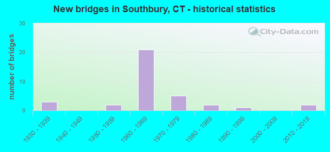
- New bridges - historical statistics
- 31930-1939
- 21950-1959
- 211960-1969
- 51970-1979
- 21980-1989
- 11990-1999
- 22010-2019

- Reconstructed bridges - Historical Statistics
- 11970-1979
- 71980-1989
- 31990-1999
- 02000-2009
- 22010-2019


- Bridge Condition - Deck
- 5.6%Very good
- 38.9%Good
- 55.6%Satisfactory

- Bridge Condition - Superstructure
- 22.2%Very good
- 16.7%Good
- 55.6%Satisfactory
- 5.6%Fair

- Bridge Condition - Substructure
- 5.6%Very good
- 38.9%Good
- 55.6%Satisfactory

- Bridge Condition - Channel
- 30.8%Very good
- 15.4%Good
- 30.8%Satisfactory
- 23.1%Fair

- Bridge Condition - Culverts
- 60.0%Good
- 20.0%Satisfactory
- 20.0%Fair
Find on map >> Show street view
Structure Number: 693, Location: 2.3 MI E OF NY STATE (Lat: 41.067744, Lng: -73.670217), Route carried "on" structure: State highway 15, Year Built: 1935, Status: Posted for load-capacity, Structure Length: 1.59m (5.22ft), Average Daily Traffic: 51,400 (year 2015), Truck Traffic: 1%, Average Future Daily Traffic: 76,375 (year 2035), Design Load: H 20, Features Intersected: PRVT ACCESS RD AND BROOK
Minimum Vertical Clearance: 30+ m (98+ ft), Kilometerpoint: 3.718, Lanes on structure: 4, Lanes under structure: 1, Base Highway Network: Yes, Owner: State Highway Agency, Approaching Roadway Width: 18.0m (59.1ft), Skew: 30 degrees, Material/Design: Concrete, Design/Construction: Frame, Number Of Spans In Main Unit: 1, Length of Maximum Span: 15.9m (52.2ft), Curb-To-Curb Width: 18.0m (59.1ft), Out-to-Out Width: 20.4m (66.9ft)
Condition: Deck: Satisfactory, Superstructure: Satisfactory, Substructure: Satisfactory, Channel: Satisfactory, Operating Rating: 78.0 metric tons, Method Used To Determine Operating Rating: Load Factor (LF), Inventory Rating: 47.2 metric tons, Method Used To Determine Inventory Rating: Load Factor (LF), Structural Evaluation: Equal to present minimum criteria, Deck Geometry: Somewhat better than minimum adequacy, Underclear: Equal to present minimum criteria, Waterway Adequacy: Equal to present desirable criteria, Approach Roadway Alignment: Equal to present desirable criteria, Designated Inspection Frequency: Every 24 months, Inspection Date: June 2020
Find on map >> Show street view
Structure Number: 1047, Location: .5 WEST OF RT. 6 & 67 (Lat: 41.500742, Lng: -73.219931), Route carried "on" structure: State highway 67, Year Built: 1958, Year Reconstructed: 1985, Status: Open, Structure Length: 3.69m (12.11ft), Average Daily Traffic: 5,700 (year 2017), Truck Traffic: 9%, Average Future Daily Traffic: 8,470 (year 2037), Design Load: HS 20, Features Intersected: POMPERAUG RIVER
Minimum Vertical Clearance: 30+ m (98+ ft), Kilometerpoint: 24.108, Lanes on structure: 2, Owner: State Highway Agency, Approaching Roadway Width: 12.2m (40.0ft), Skew: 2 degrees, Material/Design: Steel, Design/Construction: Stringer/Multi-beam, Number Of Spans In Main Unit: 1, Length of Maximum Span: 35.1m (115.2ft), Curb or Sidewalk Widths: Left: 0.5m (1.6ft), Right: 0.5m (1.6ft), Curb-To-Curb Width: 12.2m (40.0ft), Out-to-Out Width: 13.9m (45.6ft)
Condition: Deck: Good, Superstructure: Good, Substructure: Satisfactory, Channel: Fair, Operating Rating: 90.2 metric tons, Method Used To Determine Operating Rating: Load Factor (LF), Inventory Rating: 54.1 metric tons, Method Used To Determine Inventory Rating: Load Factor (LF), Structural Evaluation: Equal to present minimum criteria, Deck Geometry: Somewhat better than minimum adequacy, Waterway Adequacy: Superior to present desirable criteria, Approach Roadway Alignment: Equal to present desirable criteria, Designated Inspection Frequency: Every 24 months, Inspection Date: January 2022, Deck Structure Type: Concrete Cast-file-Place, Wearing Surface/Protective System: Wearing Surface: Bituminous, Membrane: Preformed Fabric
Find on map >> Show street view
Structure Number: 1149, Location: BTWN I-84 EXITS 13 & 14 (Lat: 41.450281, Lng: -73.248292), Route carried "on" structure: City street , Year Built: 1963, Year Reconstructed: 1993, Status: Open, Structure Length: 6.98m (22.90ft), Average Daily Traffic: 639 (year 2020), Truck Traffic: 7%, Average Future Daily Traffic: 949 (year 2040), Design Load: HS 20, Features Intersected: INTERSTATE 84, Facility Carried by Structure: ICHABOD ROAD
Minimum Vertical Clearance: 30+ m (98+ ft), Kilometerpoint: 32.509, Lanes on structure: 2, Lanes under structure: 5, Owner: State Highway Agency, Approaching Roadway Width: 10.7m (35.1ft), Skew: 1 degrees, Material/Design: Steel, Design/Construction: Stringer/Multi-beam, Number Of Spans In Main Unit: 2, Length of Maximum Span: 34.1m (111.9ft), Curb-To-Curb Width: 10.8m (35.4ft), Out-to-Out Width: 12.0m (39.4ft)
Condition: Deck: Good, Superstructure: Satisfactory, Substructure: Good, Operating Rating: 38.2 metric tons, Method Used To Determine Operating Rating: Load and Resistance Factor Rating (LRFR) rating reported by rating factor(RF) method using HL-93 loadings, Inventory Rating: 29.5 metric tons, Method Used To Determine Inventory Rating: Load and Resistance Factor Rating (LRFR) rating reported by rating factor(RF) method using HL-93 loadings, Structural Evaluation: Equal to present minimum criteria, Deck Geometry: Equal to present minimum criteria, Underclear: Meets minimum limits, Approach Roadway Alignment: High priority of replacement, Designated Inspection Frequency: Every 24 months, Inspection Date: Febuary 2020, Deck Structure Type: Concrete Cast-file-Place, Wearing Surface/Protective System: Wearing Surface: Bituminous, Membrane: Preformed Fabric, Deck Protection: Epoxy Coated Reinforcing
Find on map >> Show street view
Structure Number: 115, Location: AT EXIT 14 (Lat: 41.457994, Lng: -73.234325), Route carried "on" structure: Interstate 84, Year Built: 1963, Year Reconstructed: 2004, Status: Open, Structure Length: 3.96m (12.99ft), Average Daily Traffic: 35,650 (year 2018), Truck Traffic: 14%, Average Future Daily Traffic: 52,972 (year 2038), Design Load: HS 20, Features Intersected: ROUTE 172
Minimum Vertical Clearance: 30+ m (98+ ft), Kilometerpoint: 32.493, Lanes on structure: 3, Lanes under structure: 2, Base Highway Network: Yes, Owner: State Highway Agency, Approaching Roadway Width: 15.5m (50.9ft), Skew: 3 degrees, Material/Design: Steel, Design/Construction: Stringer/Multi-beam, Number Of Spans In Main Unit: 3, Length of Maximum Span: 16.5m (54.1ft), Curb-To-Curb Width: 15.5m (50.9ft), Out-to-Out Width: 17.7m (58.1ft)
Condition: Deck: Good, Superstructure: Very good, Substructure: Satisfactory, Operating Rating: 65.1 metric tons, Method Used To Determine Operating Rating: Load and Resistance Factor Rating (LRFR) rating reported by rating factor(RF) method using HL-93 loadings, Inventory Rating: 49.9 metric tons, Method Used To Determine Inventory Rating: Load and Resistance Factor Rating (LRFR) rating reported by rating factor(RF) method using HL-93 loadings, Structural Evaluation: Equal to present minimum criteria, Deck Geometry: Somewhat better than minimum adequacy, Underclear: High priority of corrective action, Approach Roadway Alignment: Equal to present desirable criteria, Designated Inspection Frequency: Every 24 months, Inspection Date: August 2020, Deck Structure Type: Concrete Cast-file-Place, Wearing Surface/Protective System: Wearing Surface: Bituminous, Membrane: Built-up, Deck Protection: Epoxy Coated Reinforcing
Find on map >> Show street view
Structure Number: 1151, Location: EXIT 14 (Lat: 41.458339, Lng: -73.234508), Route carried "on" structure: Interstate 84, Year Built: 1963, Status: Open, Structure Length: 3.99m (13.09ft), Average Daily Traffic: 35,650 (year 2018), Truck Traffic: 14%, Average Future Daily Traffic: 52,972 (year 2038), Design Load: HS 20, Features Intersected: ROUTE 172
Minimum Vertical Clearance: 30+ m (98+ ft), Kilometerpoint: 32.509, Lanes on structure: 2, Lanes under structure: 2, Base Highway Network: Yes, Owner: State Highway Agency, Approaching Roadway Width: 11.6m (38.1ft), Skew: 3 degrees, Material/Design: Steel, Design/Construction: Stringer/Multi-beam, Number Of Spans In Main Unit: 3, Length of Maximum Span: 16.5m (54.1ft), Curb-To-Curb Width: 12.1m (39.7ft), Out-to-Out Width: 13.3m (43.6ft)
Condition: Deck: Satisfactory, Superstructure: Satisfactory, Substructure: Satisfactory, Operating Rating: 53.8 metric tons, Method Used To Determine Operating Rating: Load and Resistance Factor Rating (LRFR) rating reported by rating factor(RF) method using HL-93 loadings, Inventory Rating: 41.5 metric tons, Method Used To Determine Inventory Rating: Load and Resistance Factor Rating (LRFR) rating reported by rating factor(RF) method using HL-93 loadings, Structural Evaluation: Equal to present minimum criteria, Deck Geometry: Equal to present minimum criteria, Underclear: Meets minimum limits, Approach Roadway Alignment: Equal to present desirable criteria, Designated Inspection Frequency: Every 24 months, Inspection Date: August 2020, Deck Structure Type: Concrete Cast-file-Place, Wearing Surface/Protective System: Wearing Surface: Bituminous, Membrane: Built-up
Find on map >> Show street view
Structure Number: 1152, Location: .9 MILE EAST OF ROUTE 172 (Lat: 41.466197, Lng: -73.221467), Route carried "on" structure: Interstate 84, Year Built: 1963, Year Reconstructed: 2003, Status: Open, Structure Length: 4.94m (16.21ft), Average Daily Traffic: 37,350 (year 2018), Truck Traffic: 14%, Average Future Daily Traffic: 55,498 (year 2038), Design Load: HS 20, Features Intersected: PETER ROAD
Minimum Vertical Clearance: 30+ m (98+ ft), Kilometerpoint: 33.909, Lanes on structure: 3, Lanes under structure: 2, Base Highway Network: Yes, Owner: State Highway Agency, Approaching Roadway Width: 15.9m (52.2ft), Skew: 2 degrees, Material/Design: Steel continuous, Design/Construction: Stringer/Multi-beam, Number Of Spans In Main Unit: 3, Length of Maximum Span: 17.7m (58.1ft), Curb-To-Curb Width: 15.9m (52.2ft), Out-to-Out Width: 17.1m (56.1ft)
Condition: Deck: Good, Superstructure: Very good, Substructure: Satisfactory, Operating Rating: 47.3 metric tons, Method Used To Determine Operating Rating: Load and Resistance Factor Rating (LRFR) rating reported by rating factor(RF) method using HL-93 loadings, Inventory Rating: 36.6 metric tons, Method Used To Determine Inventory Rating: Load and Resistance Factor Rating (LRFR) rating reported by rating factor(RF) method using HL-93 loadings, Structural Evaluation: Equal to present minimum criteria, Deck Geometry: Somewhat better than minimum adequacy, Underclear: Somewhat better than minimum adequacy, Approach Roadway Alignment: Equal to present desirable criteria, Designated Inspection Frequency: Every 24 months, Inspection Date: October 2020, Deck Structure Type: Concrete Cast-file-Place, Wearing Surface/Protective System: Wearing Surface: Bituminous, Membrane: Built-up, Deck Protection: Epoxy Coated Reinforcing
Find on map >> Show street view
Structure Number: 1153, Location: .9 MI E OF ROUTE 172 (Lat: 41.466564, Lng: -73.221661), Route carried "on" structure: Interstate 84, Year Built: 1963, Year Reconstructed: 2004, Status: Open, Structure Length: 3.96m (12.99ft), Average Daily Traffic: 37,350 (year 2018), Truck Traffic: 14%, Average Future Daily Traffic: 55,498 (year 2038), Design Load: HS 20, Features Intersected: PETER ROAD
Minimum Vertical Clearance: 30+ m (98+ ft), Kilometerpoint: 33.925, Lanes on structure: 3, Lanes under structure: 2, Base Highway Network: Yes, Owner: State Highway Agency, Approaching Roadway Width: 17.7m (58.1ft), Skew: 3 degrees, Material/Design: Steel continuous, Design/Construction: Stringer/Multi-beam, Number Of Spans In Main Unit: 3, Length of Maximum Span: 16.8m (55.1ft), Curb-To-Curb Width: 17.8m (58.4ft), Out-to-Out Width: 18.9m (62.0ft)
Condition: Deck: Good, Superstructure: Very good, Substructure: Good, Operating Rating: 34.3 metric tons, Method Used To Determine Operating Rating: Load and Resistance Factor Rating (LRFR) rating reported by rating factor(RF) method using HL-93 loadings, Inventory Rating: 26.6 metric tons, Method Used To Determine Inventory Rating: Load and Resistance Factor Rating (LRFR) rating reported by rating factor(RF) method using HL-93 loadings, Structural Evaluation: Equal to present minimum criteria, Deck Geometry: Better than present minimum criteria, Underclear: Meets minimum limits, Approach Roadway Alignment: Equal to present desirable criteria, Designated Inspection Frequency: Every 24 months, Inspection Date: October 2020, Deck Structure Type: Concrete Cast-file-Place, Wearing Surface/Protective System: Wearing Surface: Bituminous, Membrane: Built-up, Deck Protection: Epoxy Coated Reinforcing
Find on map >> Show street view
Structure Number: 1154, Location: 0.3 MI W OF US ROUTE 6 (Lat: 41.473003, Lng: -73.216433), Route carried "on" structure: City street , Year Built: 1963, Year Reconstructed: 1986, Status: Open, Structure Length: 9.80m (32.15ft), Average Daily Traffic: 5,219 (year 2021), Truck Traffic: 2%, Average Future Daily Traffic: 7,755 (year 2041), Design Load: HS 20, Features Intersected: INTERSTATE 84 & RAMP 40, Facility Carried by Structure: BULLET HILL ROAD
Minimum Vertical Clearance: 30+ m (98+ ft), Kilometerpoint: 0.885, Lanes on structure: 2, Lanes under structure: 6, Owner: State Highway Agency, Approaching Roadway Width: 9.1m (29.9ft), Skew: 1 degrees, Material/Design: Steel, Design/Construction: Stringer/Multi-beam, Number Of Spans In Main Unit: 4, Length of Maximum Span: 35.4m (116.1ft), Curb-To-Curb Width: 9.1m (29.9ft), Out-to-Out Width: 10.8m (35.4ft)
Condition: Deck: Satisfactory, Superstructure: Satisfactory, Substructure: Satisfactory, Operating Rating: 41.5 metric tons, Method Used To Determine Operating Rating: Load and Resistance Factor Rating (LRFR) rating reported by rating factor(RF) method using HL-93 loadings, Inventory Rating: 31.8 metric tons, Method Used To Determine Inventory Rating: Load and Resistance Factor Rating (LRFR) rating reported by rating factor(RF) method using HL-93 loadings, Structural Evaluation: Equal to present minimum criteria, Deck Geometry: Meets minimum limits, Underclear: High priority of corrective action, Approach Roadway Alignment: Equal to present desirable criteria, Designated Inspection Frequency: Every 24 months, Inspection Date: December 2021, Deck Structure Type: Concrete Cast-file-Place, Wearing Surface/Protective System: Wearing Surface: Bituminous, Membrane: Preformed Fabric
Find on map >> Show street view
Structure Number: 1155, Location: INTERSTATE-84 EXIT 15 (Lat: 41.476686, Lng: -73.211217), Route carried "on" structure: Interstate 84, Year Built: 1963, Year Reconstructed: 2018, Status: Open, Structure Length: 8.53m (27.99ft), Average Daily Traffic: 30,950 (year 2018), Truck Traffic: 9%, Average Future Daily Traffic: 45,989 (year 2038), Design Load: HS 20, Features Intersected: US RTE 6, RTE 67, STREAM
Minimum Vertical Clearance: 30+ m (98+ ft), Kilometerpoint: 35.341, Lanes on structure: 2, Lanes under structure: 8, Base Highway Network: Yes, Owner: State Highway Agency, Approaching Roadway Width: 12.1m (39.7ft), Skew: 11 degrees, Material/Design: Steel, Design/Construction: Stringer/Multi-beam, Number Of Spans In Main Unit: 3, Length of Maximum Span: 32.9m (107.9ft), Curb-To-Curb Width: 12.1m (39.7ft), Out-to-Out Width: 13.3m (43.6ft)
Condition: Deck: Satisfactory, Superstructure: Satisfactory, Substructure: Good, Channel: Very good, Operating Rating: 43.7 metric tons, Method Used To Determine Operating Rating: Load and Resistance Factor Rating (LRFR) rating reported by rating factor(RF) method using HL-93 loadings, Inventory Rating: 33.7 metric tons, Method Used To Determine Inventory Rating: Load and Resistance Factor Rating (LRFR) rating reported by rating factor(RF) method using HL-93 loadings, Structural Evaluation: Equal to present minimum criteria, Deck Geometry: Equal to present minimum criteria, Underclear: Equal to present minimum criteria, Waterway Adequacy: Superior to present desirable criteria, Approach Roadway Alignment: Equal to present desirable criteria, Designated Inspection Frequency: Every 24 months, Inspection Date: Febuary 2021, Total Project Cost: $2,080,000 ( Estimate for 2015), Deck Structure Type: Concrete Cast-file-Place, Wearing Surface/Protective System: Wearing Surface: Bituminous, Membrane: Built-up
Find on map >> Show street view
Structure Number: 1156, Location: I-84 WB EXIT NO. 15 (Lat: 41.476933, Lng: -73.211625), Route carried "on" structure: Interstate 84, Year Built: 1963, Year Reconstructed: 2018, Status: Open, Structure Length: 6.92m (22.70ft), Average Daily Traffic: 30,950 (year 2018), Truck Traffic: 9%, Average Future Daily Traffic: 45,989 (year 2038), Design Load: HS 20, Features Intersected: US RTE 6, RTE 67, STREAM
Minimum Vertical Clearance: 30+ m (98+ ft), Kilometerpoint: 35.341, Lanes on structure: 2, Lanes under structure: 8, Base Highway Network: Yes, Owner: State Highway Agency, Approaching Roadway Width: 12.2m (40.0ft), Skew: 10 degrees, Material/Design: Steel, Design/Construction: Stringer/Multi-beam, Number Of Spans In Main Unit: 3, Length of Maximum Span: 28.7m (94.2ft), Curb-To-Curb Width: 12.1m (39.7ft), Out-to-Out Width: 13.3m (43.6ft)
Condition: Deck: Satisfactory, Superstructure: Satisfactory, Substructure: Good, Channel: Very good, Operating Rating: 44.1 metric tons, Method Used To Determine Operating Rating: Load and Resistance Factor Rating (LRFR) rating reported by rating factor(RF) method using HL-93 loadings, Inventory Rating: 34.0 metric tons, Method Used To Determine Inventory Rating: Load and Resistance Factor Rating (LRFR) rating reported by rating factor(RF) method using HL-93 loadings, Structural Evaluation: Equal to present minimum criteria, Deck Geometry: Equal to present minimum criteria, Underclear: Equal to present minimum criteria, Waterway Adequacy: Superior to present desirable criteria, Approach Roadway Alignment: Equal to present desirable criteria, Designated Inspection Frequency: Every 24 months, Inspection Date: Febuary 2021, Total Project Cost: $2,080,000 ( Estimate for 2015), Deck Structure Type: Concrete Cast-file-Place, Wearing Surface/Protective System: Wearing Surface: Bituminous, Membrane: Built-up
Find on map >> Show street view
Structure Number: 1157, Location: .7 MI WEST OF ROUTE 188 (Lat: 41.489242, Lng: -73.174056), Route carried "on" structure: City street , Year Built: 1964, Status: Open, Structure Length: 7.83m (25.69ft), Average Daily Traffic: 756 (year 2020), Truck Traffic: 4%, Average Future Daily Traffic: 1,123 (year 2040), Design Load: H 20, Features Intersected: INTERSTATE 84, Facility Carried by Structure: BUCKS HILL ROAD
Minimum Vertical Clearance: 30+ m (98+ ft), Kilometerpoint: 3.750, Lanes on structure: 2, Lanes under structure: 6, Owner: State Highway Agency, Approaching Roadway Width: 10.4m (34.1ft), Material/Design: Steel continuous, Design/Construction: Stringer/Multi-beam, Number Of Spans In Main Unit: 2, Length of Maximum Span: 38.4m (126.0ft), Curb or Sidewalk Widths: Left: 0.5m (1.6ft), Right: 0.5m (1.6ft), Curb-To-Curb Width: 10.4m (34.1ft), Out-to-Out Width: 12.0m (39.4ft)
Condition: Deck: Satisfactory, Superstructure: Good, Substructure: Good, Operating Rating: 41.5 metric tons, Method Used To Determine Operating Rating: Load and Resistance Factor Rating (LRFR) rating reported by rating factor(RF) method using HL-93 loadings, Inventory Rating: 32.1 metric tons, Method Used To Determine Inventory Rating: Load and Resistance Factor Rating (LRFR) rating reported by rating factor(RF) method using HL-93 loadings, Structural Evaluation: Better than present minimum criteria, Deck Geometry: Equal to present minimum criteria, Underclear: Somewhat better than minimum adequacy, Approach Roadway Alignment: Equal to present desirable criteria, Designated Inspection Frequency: Every 24 months, Inspection Date: March 2020, Total Project Cost: $7,000,000 ( Estimate for 2017), Deck Structure Type: Concrete Cast-file-Place
Find on map >> Show street view
Structure Number: 1158, Location: EXIT 16 FROM I-84 (Lat: 41.493686, Lng: -73.162119), Route carried "on" structure: Interstate 84, Year Built: 1964, Year Reconstructed: 1993, Status: Open, Structure Length: 3.38m (11.09ft), Average Daily Traffic: 34,450 (year 2018), Truck Traffic: 14%, Average Future Daily Traffic: 51,189 (year 2038), Design Load: HS 20, Features Intersected: ROUTE 188
Minimum Vertical Clearance: 30+ m (98+ ft), Kilometerpoint: 39.896, Lanes on structure: 2, Lanes under structure: 2, Base Highway Network: Yes, Owner: State Highway Agency, Approaching Roadway Width: 11.6m (38.1ft), Material/Design: Steel, Design/Construction: Stringer/Multi-beam, Number Of Spans In Main Unit: 3, Length of Maximum Span: 16.2m (53.1ft), Curb-To-Curb Width: 12.1m (39.7ft), Out-to-Out Width: 13.3m (43.6ft)
Condition: Deck: Satisfactory, Superstructure: Satisfactory, Substructure: Satisfactory, Operating Rating: 64.4 metric tons, Method Used To Determine Operating Rating: Load Factor (LF), Inventory Rating: 38.1 metric tons, Method Used To Determine Inventory Rating: Load Factor (LF), Structural Evaluation: Equal to present minimum criteria, Deck Geometry: Equal to present minimum criteria, Underclear: High priority of corrective action, Approach Roadway Alignment: Equal to present desirable criteria, Designated Inspection Frequency: Every 24 months, Inspection Date: July 2020, Deck Structure Type: Concrete Cast-file-Place, Wearing Surface/Protective System: Wearing Surface: Bituminous, Membrane: Built-up
Find on map >> Show street view
Structure Number: 1159, Location: EXIT 16 FROM I-84 (Lat: 41.494003, Lng: -73.162356), Route carried "on" structure: Interstate 84, Year Built: 1964, Year Reconstructed: 1993, Status: Open, Structure Length: 3.63m (11.91ft), Average Daily Traffic: 34,450 (year 2018), Truck Traffic: 14%, Average Future Daily Traffic: 51,189 (year 2038), Design Load: HS 20, Features Intersected: ROUTE 188
Minimum Vertical Clearance: 30+ m (98+ ft), Kilometerpoint: 39.896, Lanes on structure: 3, Lanes under structure: 2, Base Highway Network: Yes, Owner: State Highway Agency, Approaching Roadway Width: 16.2m (53.1ft), Material/Design: Steel, Design/Construction: Stringer/Multi-beam, Number Of Spans In Main Unit: 3, Length of Maximum Span: 15.5m (50.9ft), Curb-To-Curb Width: 16.2m (53.1ft), Out-to-Out Width: 18.1m (59.4ft)
Condition: Deck: Satisfactory, Superstructure: Satisfactory, Substructure: Good, Operating Rating: 40.5 metric tons, Method Used To Determine Operating Rating: Load and Resistance Factor Rating (LRFR) rating reported by rating factor(RF) method using HL-93 loadings, Inventory Rating: 31.1 metric tons, Method Used To Determine Inventory Rating: Load and Resistance Factor Rating (LRFR) rating reported by rating factor(RF) method using HL-93 loadings, Structural Evaluation: Equal to present minimum criteria, Deck Geometry: Equal to present minimum criteria, Underclear: High priority of corrective action, Approach Roadway Alignment: Equal to present desirable criteria, Designated Inspection Frequency: Every 24 months, Inspection Date: July 2020, Deck Structure Type: Concrete Cast-file-Place, Wearing Surface/Protective System: Wearing Surface: Bituminous, Membrane: Built-up
Find on map >> Show street view
Structure Number: 1475, Location: I 84 EXIT 14 & 1 MILE NOR (Lat: 41.466917, Lng: -73.248364), Route carried "on" structure: State highway 172, Year Built: 1939, Year Reconstructed: 1991, Status: Open, Structure Length: 5.09m (16.70ft), Average Daily Traffic: 7,400 (year 2017), Truck Traffic: 5%, Average Future Daily Traffic: 10,996 (year 2037), Design Load: HS 20, Features Intersected: POMPERAUG RIVER
Minimum Vertical Clearance: 30+ m (98+ ft), Kilometerpoint: 1.754, Lanes on structure: 2, Owner: State Highway Agency, Approaching Roadway Width: 9.8m (32.2ft), Skew: 4 degrees, Material/Design: Steel continuous, Design/Construction: Stringer/Multi-beam, Number Of Spans In Main Unit: 2, Length of Maximum Span: 25.4m (83.3ft), Curb-To-Curb Width: 9.5m (31.2ft), Out-to-Out Width: 10.7m (35.1ft)
Condition: Deck: Good, Superstructure: Satisfactory, Substructure: Satisfactory, Channel: Satisfactory, Inventory Rating: 64.4 metric tons, Method Used To Determine Inventory Rating: Load Factor (LF), Structural Evaluation: Equal to present minimum criteria, Deck Geometry: High priority of corrective action, Waterway Adequacy: Superior to present desirable criteria, Approach Roadway Alignment: Equal to present desirable criteria, Designated Inspection Frequency: Every 24 months, Inspection Date: November 2021, Deck Structure Type: Concrete Cast-file-Place, Wearing Surface/Protective System: Wearing Surface: Bituminous, Membrane: Preformed Fabric, Deck Protection: Epoxy Coated Reinforcing
Find on map >> Show street view
Structure Number: 2751, Location: 1 MI SOUTH OF JCT RTE 67 (Lat: 41.499150, Lng: -73.256550), Route carried "on" structure: State highway 172, Year Built: 1935, Status: Open, Structure Length: 0.67m (2.20ft), Average Daily Traffic: 4,500 (year 2019), Truck Traffic: 5%, Average Future Daily Traffic: 6,687 (year 2039), Design Load: H 20, Features Intersected: TRANSYLVANIA BROOK
Minimum Vertical Clearance: 30+ m (98+ ft), Kilometerpoint: 5.681, Lanes on structure: 2, Owner: State Highway Agency, Approaching Roadway Width: 9.8m (32.2ft), Skew: 3 degrees, Material/Design: Concrete, Design/Construction: Slab, Number Of Spans In Main Unit: 1, Length of Maximum Span: 6.1m (20.0ft), Curb or Sidewalk Widths: Left: 0.5m (1.6ft), Right: 0.5m (1.6ft), Curb-To-Curb Width: 9.1m (29.9ft), Out-to-Out Width: 10.8m (35.4ft)
Condition: Deck: Satisfactory, Superstructure: Satisfactory, Substructure: Satisfactory, Channel: Fair, Operating Rating: 61.6 metric tons, Method Used To Determine Operating Rating: Load and Resistance Factor Rating (LRFR) rating reported by rating factor(RF) method using HL-93 loadings, Inventory Rating: 47.6 metric tons, Method Used To Determine Inventory Rating: Load and Resistance Factor Rating (LRFR) rating reported by rating factor(RF) method using HL-93 loadings, Structural Evaluation: Equal to present minimum criteria, Deck Geometry: Meets minimum limits, Waterway Adequacy: Equal to present minimum criteria, Approach Roadway Alignment: Equal to present desirable criteria, Designated Inspection Frequency: Every 24 months, Inspection Date: Febuary 2021, Deck Structure Type: Concrete Cast-file-Place, Wearing Surface/Protective System: Wearing Surface: Bituminous
Find on map >> Show street view
Structure Number: 3914, Location: 100' EAST OF JCT RTE 188 (Lat: 41.479717, Lng: -73.156653), Route carried "on" structure: ServiceState highway 486, Year Built: 1975, Status: Open, Structure Length: 1.10m (3.61ft), Average Daily Traffic: 3,500 (year 2017), Truck Traffic: 6%, Average Future Daily Traffic: 5,201 (year 2037), Features Intersected: EIGHT MILE BROOK
Minimum Vertical Clearance: 30+ m (98+ ft), Kilometerpoint: 0.080, Lanes on structure: 3, Owner: State Highway Agency, Approaching Roadway Width: 15.2m (49.9ft), Skew: 2 degrees, Material/Design: Concrete continuous, Design/Construction: Culvert, Number Of Spans In Main Unit: 3, Length of Maximum Span: 3.4m (11.2ft), Out-to-Out Width: 36.6m (120.1ft)
Condition: Channel: Satisfactory, Culverts: Good, Structural Evaluation: Better than present minimum criteria, Waterway Adequacy: Equal to present desirable criteria, Approach Roadway Alignment: Equal to present desirable criteria, Designated Inspection Frequency: Every 24 months, Inspection Date: August 2021
Find on map >> Show street view
Structure Number: 4243, Location: AT BEGINNING OF ROUTE 72 (Lat: 41.669167, Lng: -72.774178), Route carried "on" structure: State highway 72, Year Built: 1978, Year Reconstructed: 1984, Status: Open, Structure Length: 7.59m (24.90ft), Average Daily Traffic: 17,200 (year 2019), Truck Traffic: 8%, Average Future Daily Traffic: 25,557 (year 2039), Design Load: HS 20, Features Intersected: RTE 9SB & RTE 9-RAMP 055
Minimum Vertical Clearance: 30+ m (98+ ft), Kilometerpoint: 0.161, Lanes on structure: 2, Lanes under structure: 3, Base Highway Network: Yes, Owner: State Highway Agency, Approaching Roadway Width: 15.2m (49.9ft), Skew: 5 degrees, Material/Design: Steel, Design/Construction: Stringer/Multi-beam, Number Of Spans In Main Unit: 2, Length of Maximum Span: 38.7m (127.0ft), Curb or Sidewalk Widths: Left: 0.2m (0.7ft), Right: 0.2m (0.7ft), Curb-To-Curb Width: 15.2m (49.9ft), Out-to-Out Width: 16.3m (53.5ft)
Condition: Deck: Satisfactory, Superstructure: Fair, Substructure: Satisfactory, Operating Rating: 98.9 metric tons, Method Used To Determine Operating Rating: Load Factor (LF), Inventory Rating: 59.3 metric tons, Method Used To Determine Inventory Rating: Load Factor (LF), Structural Evaluation: Somewhat better than minimum adequacy, Deck Geometry: Superior to present desirable criteria, Underclear: Equal to present minimum criteria, Approach Roadway Alignment: Better than present minimum criteria, Designated Inspection Frequency: Every 24 months, Inspection Date: November 2021, Deck Structure Type: Concrete Cast-file-Place, Wearing Surface/Protective System: Wearing Surface: Bituminous, Membrane: Built-up
Find on map >> Show street view
Structure Number: 5031, Location: .5 MI WEST OF ROUTE 172 (Lat: 41.472358, Lng: -73.257472), Route carried "on" structure: City street , Year Built: 2019, Status: Open, Structure Length: 1.51m (4.95ft), Average Daily Traffic: 618 (year 2020), Truck Traffic: 7%, Average Future Daily Traffic: 918 (year 2040), Design Load: HL 93, Features Intersected: TRANSYLVANIA BROOK, Facility Carried by Structure: EAST FLAT HILL RD
Minimum Vertical Clearance: 30+ m (98+ ft), Kilometerpoint: 0.917, Lanes on structure: 2, Owner: Town or Township Highway Agency, Approaching Roadway Width: 9.3m (30.5ft), Skew: 1 degrees, Material/Design: Prestressed concrete, Design/Construction: Slab, Number Of Spans In Main Unit: 1, Length of Maximum Span: 13.0m (42.7ft), Curb-To-Curb Width: 7.9m (25.9ft), Out-to-Out Width: 9.3m (30.5ft)
Condition: Deck: Very good, Superstructure: Very good, Substructure: Very good, Channel: Very good, Operating Rating: 64.8 metric tons, Method Used To Determine Operating Rating: Load and Resistance Factor Rating (LRFR) rating reported by rating factor(RF) method using HL-93 loadings, Inventory Rating: 49.9 metric tons, Method Used To Determine Inventory Rating: Load and Resistance Factor Rating (LRFR) rating reported by rating factor(RF) method using HL-93 loadings, Structural Evaluation: Equal to present desirable criteria, Deck Geometry: Somewhat better than minimum adequacy, Waterway Adequacy: Better than present minimum criteria, Approach Roadway Alignment: Equal to present desirable criteria, Designated Inspection Frequency: Every 24 months, Inspection Date: July 2020, Total Project Cost: $1,525,000 ( Estimate for 2016), Deck Structure Type: Concrete Cast-file-Place, Wearing Surface/Protective System: Wearing Surface: Bituminous, Membrane: Other, Deck Protection: Epoxy Coated Reinforcing
Find on map >> Show street view
Structure Number: 5541, Location: 500' EAST FROM ROUTE 188 (Lat: 41.476319, Lng: -73.157219), Route carried "on" structure: City street , Year Built: 1950, Year Reconstructed: 1986, Status: Open, Structure Length: 1.07m (3.51ft), Average Daily Traffic: 261 (year 2018), Truck Traffic: 7%, Average Future Daily Traffic: 388 (year 2038), Design Load: HS 20, Features Intersected: EIGHT MILE BROOK, Facility Carried by Structure: BRISTOL TOWN ROAD
Minimum Vertical Clearance: 30+ m (98+ ft), Kilometerpoint: 1.223, Lanes on structure: 2, Owner: Town or Township Highway Agency, Approaching Roadway Width: 5.8m (19.0ft), Skew: 1 degrees, Material/Design: Prestressed concrete, Design/Construction: Slab, Number Of Spans In Main Unit: 1, Length of Maximum Span: 10.1m (33.1ft), Curb-To-Curb Width: 6.6m (21.7ft), Out-to-Out Width: 7.9m (25.9ft)
Condition: Deck: Good, Superstructure: Good, Substructure: Good, Channel: Good, Operating Rating: 84.8 metric tons, Method Used To Determine Operating Rating: Load Factor (LF), Inventory Rating: 50.8 metric tons, Method Used To Determine Inventory Rating: Load Factor (LF), Structural Evaluation: Better than present minimum criteria, Deck Geometry: Meets minimum limits, Waterway Adequacy: Equal to present minimum criteria, Approach Roadway Alignment: Equal to present minimum criteria, Designated Inspection Frequency: Every 24 months, Inspection Date: June 2020, Deck Structure Type: Other, Wearing Surface/Protective System: Wearing Surface: Bituminous, Membrane: Built-up, Deck Protection: Epoxy Coated Reinforcing
Find on map >> Show street view
Structure Number: 5767, Location: 1/10 MI N OF ROUTE 172 (Lat: 41.510239, Lng: -73.249022), Route carried "on" structure: State highway 67, Year Built: 1989, Status: Open, Structure Length: 1.04m (3.41ft), Average Daily Traffic: 4,300 (year 2017), Truck Traffic: 6%, Average Future Daily Traffic: 6,389 (year 2037), Features Intersected: TRANSYLVANIA BROOK
Minimum Vertical Clearance: 30+ m (98+ ft), Kilometerpoint: 20.962, Lanes on structure: 2, Base Highway Network: Yes, Owner: State Highway Agency, Approaching Roadway Width: 9.8m (32.2ft), Material/Design: Concrete, Design/Construction: Culvert, Number Of Spans In Main Unit: 3, Length of Maximum Span: 3.0m (9.8ft), Curb-To-Curb Width: 10.5m (34.4ft), Out-to-Out Width: 10.9m (35.8ft)
Condition: Channel: Satisfactory, Culverts: Satisfactory, Operating Rating: 42.6 metric tons, Method Used To Determine Operating Rating: Field evaluation and documented engineering judgment, Inventory Rating: 32.7 metric tons, Method Used To Determine Inventory Rating: Field evaluation and documented engineering judgment, Structural Evaluation: Equal to present minimum criteria, Deck Geometry: Somewhat better than minimum adequacy, Waterway Adequacy: Equal to present desirable criteria, Approach Roadway Alignment: Equal to present desirable criteria, Designated Inspection Frequency: Every 24 months, Inspection Date: August 2021
Find on map >> Show street view
Structure Number: 6259, Location: +/- 180 FT EAST OF NEW RD (Lat: 41.487933, Lng: -73.268306), Route carried "on" structure: City street , Year Built: 1989, Status: Open, Structure Length: 0.70m (2.30ft), Average Daily Traffic: 1,051 (year 2015), Truck Traffic: 7%, Average Future Daily Traffic: 1,562 (year 2035), Features Intersected: SPRUCE BROOK, Facility Carried by Structure: SPRUCE BROOK ROAD
Minimum Vertical Clearance: 30+ m (98+ ft), Kilometerpoint: 1.127, Lanes on structure: 2, Owner: Town or Township Highway Agency, Approaching Roadway Width: 7.3m (24.0ft), Material/Design: Concrete, Design/Construction: Culvert, Number Of Spans In Main Unit: 3, Length of Maximum Span: 1.5m (4.9ft)
Condition: Channel: Fair, Culverts: Fair, Operating Rating: 42.6 metric tons, Method Used To Determine Operating Rating: Field evaluation and documented engineering judgment, Inventory Rating: 32.7 metric tons, Method Used To Determine Inventory Rating: Field evaluation and documented engineering judgment, Structural Evaluation: Somewhat better than minimum adequacy, Waterway Adequacy: Better than present minimum criteria, Approach Roadway Alignment: Equal to present desirable criteria, Designated Inspection Frequency: Every 24 months, Inspection Date: July 2020
Find on map >> Show street view
Structure Number: 693, Location: 100 FT W OF LEE FARM DR (Lat: 41.433894, Lng: -73.229675), Route carried "on" structure: City street , Year Built: 1990, Status: Open, Structure Length: 0.77m (2.53ft), Average Daily Traffic: 400 (year 2018), Truck Traffic: 2%, Average Future Daily Traffic: 594 (year 2038), Features Intersected: LEE BROOK, Facility Carried by Structure: SCOUT ROAD
Minimum Vertical Clearance: 30+ m (98+ ft), Kilometerpoint: 0.032, Lanes on structure: 2, Owner: Town or Township Highway Agency, Approaching Roadway Width: 7.4m (24.3ft), Skew: 1 degrees, Material/Design: Concrete, Design/Construction: Culvert, Number Of Spans In Main Unit: 2, Length of Maximum Span: 3.7m (12.1ft)
Condition: Channel: Good, Culverts: Good, Inventory Rating: 70.5 metric tons, Method Used To Determine Inventory Rating: No rating analysis performed, Structural Evaluation: Better than present minimum criteria, Waterway Adequacy: Better than present minimum criteria, Approach Roadway Alignment: Equal to present minimum criteria, Designated Inspection Frequency: Every 24 months, Inspection Date: June 2020
Find on map >> Show street view
Structure Number: 7012, Location: 300' west of Route 172 (Lat: 41.483219, Lng: -73.258750), Route carried "on" structure: City street , Year Built: 2018, Status: Open, Structure Length: 1.34m (4.40ft), Average Daily Traffic: 350 (year 2018), Truck Traffic: 4%, Average Future Daily Traffic: 520 (year 2038), Design Load: HL 93, Features Intersected: TRANSYLVANIA BRK OVRFLOW, Facility Carried by Structure: SPRUCE BROOK ROAD
Minimum Vertical Clearance: 8.53m (27.99ft), Kilometerpoint: 0.080, Lanes on structure: 2, Owner: Town or Township Highway Agency, Approaching Roadway Width: 8.5m (27.9ft), Material/Design: Concrete, Design/Construction: Culvert, Number Of Spans In Main Unit: 3, Length of Maximum Span: 4.3m (14.1ft), Curb-To-Curb Width: 8.5m (27.9ft), Out-to-Out Width: 9.4m (30.8ft)
Condition: Channel: Very good, Culverts: Good, Operating Rating: 51.8 metric tons, Method Used To Determine Operating Rating: Load and Resistance Factor Rating (LRFR) rating reported by rating factor(RF) method using HL-93 loadings, Inventory Rating: 39.9 metric tons, Method Used To Determine Inventory Rating: Load and Resistance Factor Rating (LRFR) rating reported by rating factor(RF) method using HL-93 loadings, Structural Evaluation: Better than present minimum criteria, Deck Geometry: Equal to present minimum criteria, Waterway Adequacy: Better than present minimum criteria, Approach Roadway Alignment: Equal to present desirable criteria, Designated Inspection Frequency: Every 24 months, Inspection Date: June 2020, Wearing Surface/Protective System: Wearing Surface: Bituminous, Membrane: Built-up, Deck Protection: Epoxy Coated Reinforcing
Find on map >> Show street view
Structure Number: 1149, Location: BTWN I-84 EXITS 13 & 14 (Lat: 41.450281, Lng: -73.248292), Route carried "under" structure: Interstate 84, Year Built: 1963, Structure Length: 0. m, Average Daily Traffic: 75,100 (year 2018), Truck Traffic: 9%, Features Intersected: INTERSTATE 84, Facility Carried by Structure: ICHABOD ROAD
Minimum Vertical Clearance: 5.18m (16.99ft), Kilometerpoint: 31.028, Lanes on structure: 2, Lanes under structure: 5, Material/Design: Steel, Design/Construction: Stringer/Multi-beam, Length of Maximum Span: 34.1m (111.9ft)
Find on map >> Show street view
Structure Number: 115, Location: AT EXIT 14 (Lat: 41.457994, Lng: -73.234325), Route carried "under" structure: State highway 172, Year Built: 1963, Structure Length: 0. m, Average Daily Traffic: 8,700 (year 2017), Truck Traffic: 5%, Features Intersected: ROUTE 172, Facility Carried by Structure: INTERSTATE 84 EB
Minimum Vertical Clearance: 4.90m (16.08ft), Kilometerpoint: 0.016, Lanes on structure: 3, Lanes under structure: 2, Material/Design: Steel, Design/Construction: Stringer/Multi-beam, Length of Maximum Span: 16.5m (54.1ft)
Find on map >> Show street view
Structure Number: 1151, Location: EXIT 14 (Lat: 41.458339, Lng: -73.234508), Route carried "under" structure: State highway 172, Year Built: 1963, Structure Length: 0. m, Average Daily Traffic: 8,700 (year 2017), Truck Traffic: 5%, Features Intersected: ROUTE 172, Facility Carried by Structure: INTERSTATE 84 WB
Minimum Vertical Clearance: 5.16m (16.93ft), Kilometerpoint: 0.241, Lanes on structure: 2, Lanes under structure: 2, Material/Design: Steel, Design/Construction: Stringer/Multi-beam, Length of Maximum Span: 16.5m (54.1ft)
Find on map >> Show street view
Structure Number: 1154, Location: 0.3 MI W OF US ROUTE 6 (Lat: 41.473003, Lng: -73.216433), Route carried "under" structure: Interstate 84, Year Built: 1963, Structure Length: 0. m, Average Daily Traffic: 68,100 (year 2018), Truck Traffic: 9%, Features Intersected: INTERSTATE 84 & RAMP 40, Facility Carried by Structure: BULLET HILL ROAD
Minimum Vertical Clearance: 7.62m (25.00ft), Kilometerpoint: 34.794, Lanes on structure: 2, Lanes under structure: 5, Material/Design: Steel, Design/Construction: Stringer/Multi-beam, Length of Maximum Span: 35.4m (116.1ft)
Find on map >> Show street view
Structure Number: 1154, Location: 0.3 MI W OF US ROUTE 6 (Lat: 41.473003, Lng: -73.216433), Route carried "under" structure: Ramp Interstate 84, Year Built: 1963, Structure Length: 0. m, Average Daily Traffic: 5,800 (year 2018), Truck Traffic: 9%, Features Intersected: INTERSTATE 84 & RAMP 40, Facility Carried by Structure: BULLET HILL ROAD
Minimum Vertical Clearance: 4.93m (16.17ft), Kilometerpoint: 0.740, Lanes on structure: 2, Lanes under structure: 1, Material/Design: Steel, Design/Construction: Stringer/Multi-beam, Length of Maximum Span: 35.4m (116.1ft)
Find on map >> Show street view
Structure Number: 1155, Location: INTERSTATE-84 EXIT 15 (Lat: 41.476686, Lng: -73.211217), Route carried "under" structure: US 6, Year Built: 1963, Structure Length: 0. m, Average Daily Traffic: 20,400 (year 2017), Truck Traffic: 6%, Features Intersected: US RTE 6, RTE 67, STREAM, Facility Carried by Structure: INTERSTATE 84 EB
Minimum Vertical Clearance: 8.46m (27.76ft), Kilometerpoint: 35.792, Lanes on structure: 2, Lanes under structure: 8, Material/Design: Steel, Design/Construction: Stringer/Multi-beam, Length of Maximum Span: 32.9m (107.9ft)
Find on map >> Show street view
Structure Number: 1156, Location: I-84 WB EXIT NO. 15 (Lat: 41.476933, Lng: -73.211625), Route carried "under" structure: US 6, Year Built: 1963, Structure Length: 0. m, Average Daily Traffic: 20,400 (year 2017), Truck Traffic: 6%, Features Intersected: US RTE 6, RTE 67, STREAM, Facility Carried by Structure: INTERSTATE 84 WB
Minimum Vertical Clearance: 5.46m (17.91ft), Kilometerpoint: 35.840, Lanes on structure: 2, Lanes under structure: 8, Material/Design: Steel, Design/Construction: Stringer/Multi-beam, Length of Maximum Span: 28.7m (94.2ft)
Find on map >> Show street view
Structure Number: 1157, Location: .7 MI WEST OF ROUTE 188 (Lat: 41.489242, Lng: -73.174056), Route carried "under" structure: Interstate 84, Year Built: 1964, Structure Length: 0. m, Average Daily Traffic: 72,100 (year 2018), Truck Traffic: 9%, Features Intersected: INTERSTATE 84, Facility Carried by Structure: BUCKS HILL ROAD
Minimum Vertical Clearance: 5.46m (17.91ft), Kilometerpoint: 38.801, Lanes on structure: 2, Lanes under structure: 6, Material/Design: Steel continuous, Design/Construction: Stringer/Multi-beam, Length of Maximum Span: 38.4m (126.0ft)
Find on map >> Show street view
Structure Number: 1158, Location: EXIT 16 FROM I-84 (Lat: 41.493686, Lng: -73.162119), Route carried "under" structure: State highway 188, Year Built: 1964, Structure Length: 0. m, Average Daily Traffic: 8,300 (year 2017), Truck Traffic: 6%, Features Intersected: ROUTE 188, Facility Carried by Structure: INTERSTATE 84 EB
Minimum Vertical Clearance: 4.42m (14.50ft), Kilometerpoint: 16.464, Lanes on structure: 2, Lanes under structure: 2, Material/Design: Steel, Design/Construction: Stringer/Multi-beam, Length of Maximum Span: 16.2m (53.1ft)
Find on map >> Show street view
Structure Number: 1159, Location: EXIT 16 FROM I-84 (Lat: 41.494003, Lng: -73.162356), Route carried "under" structure: State highway 188, Year Built: 1964, Structure Length: 0. m, Average Daily Traffic: 8,300 (year 2017), Truck Traffic: 6%, Features Intersected: ROUTE 188, Facility Carried by Structure: INTERSTATE 84 WB
Minimum Vertical Clearance: 4.52m (14.83ft), Kilometerpoint: 16.496, Lanes on structure: 3, Lanes under structure: 2, Material/Design: Steel, Design/Construction: Stringer/Multi-beam, Length of Maximum Span: 15.5m (50.9ft)
Find on map >> Show street view
Structure Number: 4264, Location: I-84 EXIT 13 (Lat: 41.442225, Lng: -73.249275), Route carried "under" structure: Ramp Interstate 84, Year Built: 1978, Structure Length: 0. m, Average Daily Traffic: 700 (year 2018), Truck Traffic: 14%, Features Intersected: INTERSTATE 84, Facility Carried by Structure: RIVER ROAD #1
Minimum Vertical Clearance: 7.44m (24.41ft), Kilometerpoint: 30.159, Lanes on structure: 2, Lanes under structure: 1, Material/Design: Steel continuous, Design/Construction: Box Beam or Girders - Single/Spread, Length of Maximum Span: 54.3m (178.1ft)
Find on map >> Show street view
Structure Number: 4264, Location: I-84 EXIT 13 (Lat: 41.442225, Lng: -73.249275), Route carried "under" structure: Ramp Interstate 84, Year Built: 1978, Structure Length: 0. m, Average Daily Traffic: 500 (year 2018), Truck Traffic: 14%, Features Intersected: INTERSTATE 84, Facility Carried by Structure: RIVER ROAD #1
Minimum Vertical Clearance: 5.28m (17.32ft), Kilometerpoint: 30.159, Lanes on structure: 2, Lanes under structure: 1, Material/Design: Steel continuous, Design/Construction: Box Beam or Girders - Single/Spread, Length of Maximum Span: 54.3m (178.1ft)
Find on map >> Show street view
Structure Number: 4264, Location: I-84 EXIT 13 (Lat: 41.442225, Lng: -73.249275), Route carried "under" structure: Interstate 84, Year Built: 1978, Structure Length: 0. m, Average Daily Traffic: 75,100 (year 2018), Truck Traffic: 14%, Features Intersected: INTERSTATE 84, Facility Carried by Structure: RIVER ROAD #1
Minimum Vertical Clearance: 7.34m (24.08ft), Kilometerpoint: 30.159, Lanes on structure: 2, Lanes under structure: 4, Material/Design: Steel continuous, Design/Construction: Box Beam or Girders - Single/Spread, Length of Maximum Span: 54.3m (178.1ft)