Bridge Statistics for Spanish Fort, Alabama (AL)
Condition, Traffic, Stress, Structural Evaluation, Project Costs
- National Bridge Inventory (NBI) Statistics
- 29Number of bridges
- 1,083ft / 330mTotal length
- $117,810,000Total costs
- 500,447Total average daily traffic
- 79,982Total average daily truck traffic
- National Bridge Inventory (NBI) Registered Bridges for Spanish Fort
- No street view available for this location
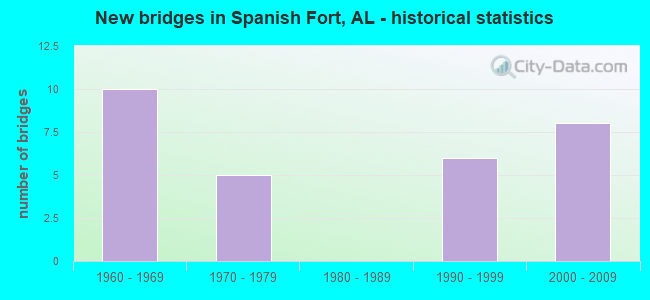
- New bridges - historical statistics
- 101960-1969
- 51970-1979
- 61990-1999
- 82000-2009
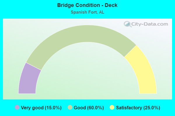
- Bridge Condition - Deck
- 15.0%Very good
- 60.0%Good
- 25.0%Satisfactory
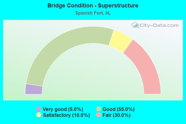
- Bridge Condition - Superstructure
- 5.0%Very good
- 55.0%Good
- 10.0%Satisfactory
- 30.0%Fair
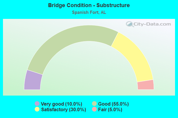
- Bridge Condition - Substructure
- 10.0%Very good
- 55.0%Good
- 30.0%Satisfactory
- 5.0%Fair
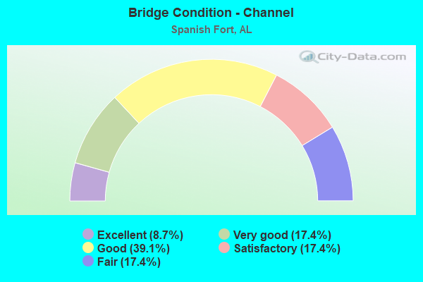
- Bridge Condition - Channel
- 8.7%Excellent
- 17.4%Very good
- 39.1%Good
- 17.4%Satisfactory
- 17.4%Fair
Find on map >> Show street view
Structure Number: 7804, Location: 2.1 M N JCT US 31 * 225 (Lat: 30.699322, Lng: -87.902308), Route carried "on" structure: State highway 225, Year Built: 1962, Status: Open, Structure Length: 13.47m (44.19ft), Average Daily Traffic: 8,282 (year 2019), Truck Traffic: 4%, Average Future Daily Traffic: 12,423 (year 2039), Design Load: HS 20, Features Intersected: BAY MINETTE CREEK
Minimum Vertical Clearance: 30+ m (98+ ft), Kilometerpoint: 3.393, Lanes on structure: 2, Owner: State Highway Agency, Approaching Roadway Width: 8.6m (28.2ft), Material/Design: Concrete, Design/Construction: Tee Beam, Number Of Spans In Main Unit: 13, Length of Maximum Span: 10.4m (34.1ft), Curb-To-Curb Width: 8.6m (28.2ft), Out-to-Out Width: 10.1m (33.1ft)
Condition: Deck: Satisfactory, Superstructure: Fair, Substructure: Fair, Channel: Good, Operating Rating: 37.5 metric tons, Method Used To Determine Operating Rating: Load Factor (LF), Inventory Rating: 22.5 metric tons, Method Used To Determine Inventory Rating: Load Factor (LF), Structural Evaluation: Somewhat better than minimum adequacy, Deck Geometry: Meets minimum limits, Waterway Adequacy: Equal to present minimum criteria, Approach Roadway Alignment: Equal to present minimum criteria, Length Of Structure Improvement: 14.28m (46.85ft), Designated Inspection Frequency: Every 24 months, Underwater Inspection Frequency: Every 24 months, Inspection Date: December 2020, Underwater Inspection Date: October 2021, Bridge Improvement Cost: $3,232,000, Roadway Improvement Cost: $323,000, Total Project Cost: $3,555,000 ( Estimate for 2022), Deck Structure Type: Concrete Cast-file-Place
Find on map >> Show street view
Structure Number: 9071, Location: 0.3 MI E I10 MIDBAY INTCH (Lat: 30.676578, Lng: -87.977439), Route carried "on" structure: US 90, Year Built: 1966, Status: Open, Structure Length: 1.31m (4.30ft), Average Daily Traffic: 22,821 (year 2019), Truck Traffic: 4%, Average Future Daily Traffic: 34,232 (year 2039), Design Load: HS 20, Features Intersected: CHACALOOCHEE BAY
Minimum Vertical Clearance: 30+ m (98+ ft), Kilometerpoint: 63.450, Lanes on structure: 4, Owner: State Highway Agency, Approaching Roadway Width: 23.8m (78.1ft), Skew: 10 degrees, Material/Design: Concrete, Design/Construction: Culvert, Number Of Spans In Main Unit: 4, Length of Maximum Span: 3.0m (9.8ft)
Condition: Channel: Fair, Culverts: Fair, Operating Rating: 55.1 metric tons, Method Used To Determine Operating Rating: Load Factor (LF), Inventory Rating: 33.0 metric tons, Method Used To Determine Inventory Rating: Load Factor (LF), Structural Evaluation: Somewhat better than minimum adequacy, Waterway Adequacy: Equal to present minimum criteria, Approach Roadway Alignment: Equal to present desirable criteria, Length Of Structure Improvement: 1.98m (6.50ft), Designated Inspection Frequency: Every 24 months, Underwater Inspection Frequency: Every 24 months, Inspection Date: October 2020, Underwater Inspection Date: October 2020, Bridge Improvement Cost: $1,146,000, Roadway Improvement Cost: $115,000, Total Project Cost: $1,261,000 ( Estimate for 2022)
Find on map >> Show street view
Structure Number: 9851, Location: 0.2 MI E US 90 (Lat: 30.656053, Lng: -87.908833), Route carried "on" structure: Interstate 10, Year Built: 1969, Status: Open, Structure Length: 0.79m (2.59ft), Average Daily Traffic: 61,100 (year 2016), Truck Traffic: 21%, Average Future Daily Traffic: 91,650 (year 2036), Design Load: HS 20, Features Intersected: JOE'S BRANCH
Minimum Vertical Clearance: 30+ m (98+ ft), Kilometerpoint: 56.836, Lanes on structure: 8, Base Highway Network: Yes, Owner: State Highway Agency, Approaching Roadway Width: 23.7m (77.8ft), Skew: 20 degrees, Material/Design: Concrete, Design/Construction: Culvert, Number Of Spans In Main Unit: 3, Length of Maximum Span: 2.4m (7.9ft)
Condition: Channel: Satisfactory, Culverts: Fair, Operating Rating: 88.9 metric tons, Method Used To Determine Operating Rating: Load Factor (LF), Inventory Rating: 88.9 metric tons, Method Used To Determine Inventory Rating: Load Factor (LF), Structural Evaluation: Somewhat better than minimum adequacy, Waterway Adequacy: Equal to present minimum criteria, Approach Roadway Alignment: Equal to present desirable criteria, Length Of Structure Improvement: 1.45m (4.76ft), Designated Inspection Frequency: Every 24 months, Inspection Date: June 2020, Bridge Improvement Cost: $7,765,000, Roadway Improvement Cost: $777,000, Total Project Cost: $8,542,000 ( Estimate for 2022)
Find on map >> Show street view
Structure Number: 9853, Location: 1.9 MI E JCT US 90 * I-10 (Lat: 30.659850, Lng: -87.880017), Route carried "on" structure: Interstate 10, Year Built: 1969, Status: Open, Structure Length: 1.49m (4.89ft), Average Daily Traffic: 60,281 (year 2018), Truck Traffic: 21%, Average Future Daily Traffic: 90,422 (year 2038), Design Load: HS 20, Features Intersected: D'OLIVE CREEK
Minimum Vertical Clearance: 30+ m (98+ ft), Kilometerpoint: 59.607, Lanes on structure: 4, Base Highway Network: Yes, Owner: State Highway Agency, Approaching Roadway Width: 23.7m (77.8ft), Skew: 23 degrees, Material/Design: Concrete, Design/Construction: Culvert, Number Of Spans In Main Unit: 4, Length of Maximum Span: 3.7m (12.1ft)
Condition: Channel: Fair, Culverts: Fair, Operating Rating: 88.9 metric tons, Method Used To Determine Operating Rating: Load Factor (LF), Inventory Rating: 88.9 metric tons, Method Used To Determine Inventory Rating: Load Factor (LF), Structural Evaluation: Somewhat better than minimum adequacy, Waterway Adequacy: Better than present minimum criteria, Approach Roadway Alignment: Equal to present desirable criteria, Length Of Structure Improvement: 2.17m (7.12ft), Designated Inspection Frequency: Every 24 months, Other Special Inspection Frequency: Every 6 months, Inspection Date: June 2020, Other Special Inspection Date: December 2021, Bridge Improvement Cost: $5,069,000, Roadway Improvement Cost: $507,000, Total Project Cost: $5,576,000 ( Estimate for 2022)
Find on map >> Show street view
Structure Number: 9854, Location: 4.2 MI E JCT US 90 (Lat: 30.662619, Lng: -87.841319), Route carried "on" structure: Interstate 10, Year Built: 1969, Status: Open, Structure Length: 0.94m (3.08ft), Average Daily Traffic: 51,388 (year 2018), Truck Traffic: 21%, Average Future Daily Traffic: 77,082 (year 2038), Design Load: HS 20, Features Intersected: TURKEY BRANCH
Minimum Vertical Clearance: 30+ m (98+ ft), Kilometerpoint: 63.349, Lanes on structure: 4, Base Highway Network: Yes, Owner: State Highway Agency, Approaching Roadway Width: 23.8m (78.1ft), Skew: 1 degrees, Material/Design: Concrete, Design/Construction: Culvert, Number Of Spans In Main Unit: 3, Length of Maximum Span: 3.0m (9.8ft)
Condition: Channel: Satisfactory, Culverts: Fair, Operating Rating: 88.9 metric tons, Method Used To Determine Operating Rating: Load Factor (LF), Inventory Rating: 88.9 metric tons, Method Used To Determine Inventory Rating: Load Factor (LF), Structural Evaluation: Somewhat better than minimum adequacy, Waterway Adequacy: Equal to present minimum criteria, Approach Roadway Alignment: Equal to present desirable criteria, Length Of Structure Improvement: 1.62m (5.31ft), Designated Inspection Frequency: Every 24 months, Inspection Date: June 2020, Bridge Improvement Cost: $3,551,000, Roadway Improvement Cost: $355,000, Total Project Cost: $3,906,000 ( Estimate for 2022)
Find on map >> Show street view
Structure Number: 9855, Location: 4.6 MI E JCT US 90 (Lat: 30.661506, Lng: -87.834097), Route carried "on" structure: Interstate 10, Year Built: 1969, Status: Open, Structure Length: 0.61m (2.00ft), Average Daily Traffic: 51,388 (year 2018), Truck Traffic: 21%, Average Future Daily Traffic: 77,082 (year 2038), Design Load: HS 20, Features Intersected: STREAM
Minimum Vertical Clearance: 30+ m (98+ ft), Kilometerpoint: 63.992, Lanes on structure: 4, Base Highway Network: Yes, Owner: State Highway Agency, Approaching Roadway Width: 23.5m (77.1ft), Skew: 23 degrees, Material/Design: Concrete, Design/Construction: Culvert, Number Of Spans In Main Unit: 2, Length of Maximum Span: 2.4m (7.9ft)
Condition: Channel: Fair, Culverts: Fair, Operating Rating: 88.9 metric tons, Method Used To Determine Operating Rating: Load Factor (LF), Inventory Rating: 88.9 metric tons, Method Used To Determine Inventory Rating: Load Factor (LF), Structural Evaluation: Somewhat better than minimum adequacy, Waterway Adequacy: Equal to present minimum criteria, Approach Roadway Alignment: Equal to present desirable criteria, Length Of Structure Improvement: 1.22m (4.00ft), Designated Inspection Frequency: Every 24 months, Inspection Date: June 2020, Bridge Improvement Cost: $4,604,000, Roadway Improvement Cost: $460,000, Total Project Cost: $5,064,000 ( Estimate for 2022)
Find on map >> Show street view
Structure Number: 10042, Location: 0.2 MI E JCT I-10 (Lat: 30.653153, Lng: -87.912181), Route carried "on" structure: US 98, Year Built: 1969, Status: Open, Structure Length: 6.22m (20.41ft), Average Daily Traffic: 19,750 (year 2019), Truck Traffic: 5%, Average Future Daily Traffic: 28,832 (year 2039), Design Load: HS 20, Features Intersected: D'OLIVE CREEK
Minimum Vertical Clearance: 30+ m (98+ ft), Kilometerpoint: 57.795, Lanes on structure: 2, Owner: State Highway Agency, Approaching Roadway Width: 8.5m (27.9ft), Skew: 10 degrees, Material/Design: Concrete, Design/Construction: Tee Beam, Number Of Spans In Main Unit: 6, Length of Maximum Span: 10.4m (34.1ft), Curb-To-Curb Width: 11.9m (39.0ft), Out-to-Out Width: 13.1m (43.0ft)
Condition: Deck: Good, Superstructure: Fair, Substructure: Satisfactory, Channel: Satisfactory, Operating Rating: 45.6 metric tons, Method Used To Determine Operating Rating: Load Factor (LF), Inventory Rating: 27.4 metric tons, Method Used To Determine Inventory Rating: Load Factor (LF), Structural Evaluation: Somewhat better than minimum adequacy, Deck Geometry: Better than present minimum criteria, Waterway Adequacy: Equal to present minimum criteria, Approach Roadway Alignment: Better than present minimum criteria, Length Of Structure Improvement: 7.26m (23.82ft), Designated Inspection Frequency: Every 24 months, Underwater Inspection Frequency: Every 24 months, Inspection Date: November 2020, Underwater Inspection Date: November 2021, Bridge Improvement Cost: $2,140,000, Roadway Improvement Cost: $214,000, Total Project Cost: $2,354,000 ( Estimate for 2022), Deck Structure Type: Concrete Cast-file-Place
Find on map >> Show street view
Structure Number: 10043, Location: 0.2 MI E JCT I-10 (Lat: 30.653153, Lng: -87.912389), Route carried "on" structure: US 98, Year Built: 1969, Status: Open, Structure Length: 6.22m (20.41ft), Average Daily Traffic: 19,750 (year 2019), Truck Traffic: 5%, Average Future Daily Traffic: 29,625 (year 2039), Design Load: HS 20, Features Intersected: D'OLIVE CREEK
Minimum Vertical Clearance: 30+ m (98+ ft), Kilometerpoint: 57.795, Lanes on structure: 3, Owner: State Highway Agency, Approaching Roadway Width: 11.9m (39.0ft), Skew: 10 degrees, Material/Design: Concrete, Design/Construction: Tee Beam, Number Of Spans In Main Unit: 6, Length of Maximum Span: 10.4m (34.1ft), Curb-To-Curb Width: 11.9m (39.0ft), Out-to-Out Width: 13.1m (43.0ft)
Condition: Deck: Good, Superstructure: Fair, Substructure: Satisfactory, Channel: Fair, Operating Rating: 43.8 metric tons, Method Used To Determine Operating Rating: Load Factor (LF), Inventory Rating: 26.2 metric tons, Method Used To Determine Inventory Rating: Load Factor (LF), Structural Evaluation: Somewhat better than minimum adequacy, Deck Geometry: High priority of corrective action, Waterway Adequacy: Equal to present minimum criteria, Approach Roadway Alignment: Equal to present minimum criteria, Length Of Structure Improvement: 7.26m (23.82ft), Designated Inspection Frequency: Every 24 months, Underwater Inspection Frequency: Every 24 months, Inspection Date: November 2020, Underwater Inspection Date: November 2021, Bridge Improvement Cost: $2,140,000, Roadway Improvement Cost: $214,000, Total Project Cost: $2,354,000 ( Estimate for 2022), Deck Structure Type: Concrete Cast-file-Place
Find on map >> Show street view
Structure Number: 11925, Location: I10-US90-CHACALOOCHEE BAY (Lat: 30.680650, Lng: -87.991600), Route carried "on" structure: Ramp Interstate 10, Year Built: 1978, Status: Open, Structure Length: 21.49m (70.51ft), Average Daily Traffic: 1,372 (year 2019), Truck Traffic: 4%, Average Future Daily Traffic: 2,058 (year 2039), Design Load: HS 20, Features Intersected: US 90
Minimum Vertical Clearance: 30+ m (98+ ft), Kilometerpoint: 48.193, Lanes on structure: 1, Owner: State Highway Agency, Approaching Roadway Width: 7.6m (24.9ft), Material/Design: Prestressed concrete, Design/Construction: Stringer/Multi-beam, Number Of Spans In Main Unit: 10, Number Of Approach Spans: 8, Length of Maximum Span: 19.8m (65.0ft), Curb-To-Curb Width: 7.6m (24.9ft), Out-to-Out Width: 8.4m (27.6ft)
Condition: Deck: Satisfactory, Superstructure: Fair, Substructure: Satisfactory, Channel: Good, Operating Rating: 42.2 metric tons, Method Used To Determine Operating Rating: Load Factor (LF), Inventory Rating: 25.3 metric tons, Method Used To Determine Inventory Rating: Load Factor (LF), Structural Evaluation: Somewhat better than minimum adequacy, Deck Geometry: Better than present minimum criteria, Waterway Adequacy: Equal to present desirable criteria, Approach Roadway Alignment: Equal to present minimum criteria, Length Of Structure Improvement: 21.49m (70.51ft), Designated Inspection Frequency: Every 24 months, Underwater Inspection Frequency: Every 24 months, Inspection Date: December 2020, Underwater Inspection Date: Febuary 2021, Bridge Improvement Cost: $3,978,000, Roadway Improvement Cost: $398,000, Total Project Cost: $4,376,000 ( Estimate for 2022), Deck Structure Type: Concrete Cast-file-Place
Find on map >> Show street view
Structure Number: 11926, Location: I10-US90-CHACALOOCHEE BAY (Lat: 30.677850, Lng: -87.988844), Route carried "on" structure: Ramp Interstate 10, Year Built: 1978, Status: Open, Structure Length: 36.73m (120.51ft), Average Daily Traffic: 5,893 (year 2019), Truck Traffic: 13%, Average Future Daily Traffic: 8,839 (year 2039), Design Load: HS 20, Features Intersected: US 90
Minimum Vertical Clearance: 30+ m (98+ ft), Kilometerpoint: 48.448, Lanes on structure: 1, Owner: State Highway Agency, Approaching Roadway Width: 7.6m (24.9ft), Material/Design: Prestressed concrete, Design/Construction: Stringer/Multi-beam, Number Of Spans In Main Unit: 20, Number Of Approach Spans: 8, Length of Maximum Span: 19.8m (65.0ft), Curb-To-Curb Width: 7.5m (24.6ft), Out-to-Out Width: 8.4m (27.6ft)
Condition: Deck: Satisfactory, Superstructure: Fair, Substructure: Satisfactory, Channel: Good, Operating Rating: 55.3 metric tons, Method Used To Determine Operating Rating: Load Factor (LF), Inventory Rating: 33.1 metric tons, Method Used To Determine Inventory Rating: Load Factor (LF), Structural Evaluation: Somewhat better than minimum adequacy, Deck Geometry: Better than present minimum criteria, Waterway Adequacy: Equal to present minimum criteria, Approach Roadway Alignment: Equal to present minimum criteria, Length Of Structure Improvement: 36.73m (120.51ft), Designated Inspection Frequency: Every 24 months, Underwater Inspection Frequency: Every 24 months, Inspection Date: January 2021, Underwater Inspection Date: Febuary 2021, Bridge Improvement Cost: $6,800,000, Roadway Improvement Cost: $680,000, Total Project Cost: $7,480,000 ( Estimate for 2022), Deck Structure Type: Concrete Cast-file-Place
Find on map >> Show street view
Structure Number: 11927, Location: I10-US90-CHACALOOCHEE BAY (Lat: 30.677008, Lng: -87.984483), Route carried "on" structure: Ramp Interstate 10, Year Built: 1978, Status: Open, Structure Length: 23.01m (75.49ft), Average Daily Traffic: 1,289 (year 2019), Truck Traffic: 4%, Average Future Daily Traffic: 1,933 (year 2039), Design Load: HS 20, Features Intersected: US 90
Minimum Vertical Clearance: 30+ m (98+ ft), Kilometerpoint: 48.605, Lanes on structure: 1, Owner: State Highway Agency, Approaching Roadway Width: 13.4m (44.0ft), Material/Design: Prestressed concrete, Design/Construction: Stringer/Multi-beam, Number Of Spans In Main Unit: 11, Number Of Approach Spans: 8, Length of Maximum Span: 19.8m (65.0ft), Curb-To-Curb Width: 7.6m (24.9ft), Out-to-Out Width: 8.4m (27.6ft)
Condition: Deck: Satisfactory, Superstructure: Fair, Substructure: Good, Channel: Good, Operating Rating: 38.0 metric tons, Method Used To Determine Operating Rating: Load Factor (LF), Inventory Rating: 22.5 metric tons, Method Used To Determine Inventory Rating: Load Factor (LF), Structural Evaluation: Somewhat better than minimum adequacy, Deck Geometry: Better than present minimum criteria, Waterway Adequacy: Equal to present minimum criteria, Approach Roadway Alignment: Better than present minimum criteria, Length Of Structure Improvement: 23.01m (75.49ft), Designated Inspection Frequency: Every 24 months, Underwater Inspection Frequency: Every 24 months, Inspection Date: January 2021, Underwater Inspection Date: Febuary 2021, Bridge Improvement Cost: $4,260,000, Roadway Improvement Cost: $426,000, Total Project Cost: $4,686,000 ( Estimate for 2022), Deck Structure Type: Concrete Cast-file-Place
Find on map >> Show street view
Structure Number: 11929, Location: I10 @ US98-DAPHNE (Lat: 30.655083, Lng: -87.915472), Route carried "on" structure: Ramp Interstate 10, Year Built: 1978, Status: Open, Structure Length: 25.57m (83.89ft), Average Daily Traffic: 10,435 (year 2019), Truck Traffic: 3%, Average Future Daily Traffic: 15,653 (year 2039), Design Load: HS 20, Features Intersected: US 98
Minimum Vertical Clearance: 30+ m (98+ ft), Kilometerpoint: 56.198, Lanes on structure: 2, Owner: State Highway Agency, Approaching Roadway Width: 7.6m (24.9ft), Material/Design: Prestressed concrete, Design/Construction: Stringer/Multi-beam, Number Of Spans In Main Unit: 13, Length of Maximum Span: 19.8m (65.0ft), Curb-To-Curb Width: 7.6m (24.9ft), Out-to-Out Width: 8.4m (27.6ft)
Condition: Deck: Good, Superstructure: Good, Substructure: Good, Channel: Good, Operating Rating: 44.0 metric tons, Method Used To Determine Operating Rating: Load Factor (LF), Inventory Rating: 26.1 metric tons, Method Used To Determine Inventory Rating: Load Factor (LF), Structural Evaluation: Equal to present minimum criteria, Deck Geometry: High priority of replacement, Waterway Adequacy: Superior to present desirable criteria, Approach Roadway Alignment: Equal to present minimum criteria, Length Of Structure Improvement: 25.57m (83.89ft), Designated Inspection Frequency: Every 24 months, Underwater Inspection Frequency: Every 24 months, Inspection Date: December 2020, Underwater Inspection Date: Febuary 2021, Bridge Improvement Cost: $4,734,000, Roadway Improvement Cost: $473,000, Total Project Cost: $5,207,000 ( Estimate for 2022), Deck Structure Type: Concrete Cast-file-Place
Find on map >> Show street view
Structure Number: 11988, Location: 2.4 MI W SPANISH FT (Lat: 30.672933, Lng: -87.954964), Route carried "on" structure: US 90, Year Built: 1978, Status: Open, Structure Length: 49.53m (162.50ft), Average Daily Traffic: 10,833 (year 2020), Truck Traffic: 4%, Average Future Daily Traffic: 16,249 (year 2040), Design Load: HS 20, Features Intersected: APALACHEE RIVER
Minimum Vertical Clearance: 30+ m (98+ ft), Kilometerpoint: 65.660, Lanes on structure: 2, Owner: State Highway Agency, Approaching Roadway Width: 12.2m (40.0ft), Skew: 10 degrees, Material/Design: Prestressed concrete, Design/Construction: Stringer/Multi-beam, Number Of Spans In Main Unit: 25, Length of Maximum Span: 19.8m (65.0ft), Curb-To-Curb Width: 11.9m (39.0ft), Out-to-Out Width: 12.8m (42.0ft)
Condition: Deck: Good, Superstructure: Satisfactory, Substructure: Satisfactory, Channel: Good, Operating Rating: 69.9 metric tons, Method Used To Determine Operating Rating: Load Factor (LF), Inventory Rating: 41.9 metric tons, Method Used To Determine Inventory Rating: Load Factor (LF), Structural Evaluation: Equal to present minimum criteria, Deck Geometry: Somewhat better than minimum adequacy, Waterway Adequacy: Equal to present minimum criteria, Approach Roadway Alignment: Better than present minimum criteria, Length Of Structure Improvement: 49.53m (162.50ft), Designated Inspection Frequency: Every 24 months, Underwater Inspection Frequency: Every 24 months, Inspection Date: September 2021, Underwater Inspection Date: March 2021, Bridge Improvement Cost: $14,264,000, Roadway Improvement Cost: $1,426,000, Total Project Cost: $15,690,000 ( Estimate for 2022), Deck Structure Type: Concrete Cast-file-Place
Find on map >> Show street view
Structure Number: 16183, Location: 0.7 MI W AL 225 (Lat: 30.738731, Lng: -87.896831), Route carried "on" structure: State lands road 225, Year Built: 1994, Status: Open, Structure Length: 2.48m (8.14ft), Average Daily Traffic: 138 (year 2020), Truck Traffic: 1%, Average Future Daily Traffic: 207 (year 2040), Design Load: HS 20, Features Intersected: AL 225 AT BLAKLEY ST PK., Facility Carried by Structure: UP SHAY BRANCH RD
Minimum Vertical Clearance: 30+ m (98+ ft), Kilometerpoint: 0.658, Lanes on structure: 2, Owner: State Park, Forest, or Reservation Agency, Approaching Roadway Width: 6.6m (21.7ft), Material/Design: Prestressed concrete, Design/Construction: Stringer/Multi-beam, Number Of Spans In Main Unit: 1, Length of Maximum Span: 24.8m (81.4ft), Curb-To-Curb Width: 7.2m (23.6ft), Out-to-Out Width: 7.5m (24.6ft)
Condition: Deck: Good, Superstructure: Good, Substructure: Good, Channel: Good, Operating Rating: 88.9 metric tons, Method Used To Determine Operating Rating: Load Factor (LF), Inventory Rating: 64.6 metric tons, Method Used To Determine Inventory Rating: Load Factor (LF), Structural Evaluation: Better than present minimum criteria, Deck Geometry: Meets minimum limits, Waterway Adequacy: Better than present minimum criteria, Approach Roadway Alignment: Better than present minimum criteria, Length Of Structure Improvement: 3.35m (10.99ft), Designated Inspection Frequency: Every 24 months, Inspection Date: Febuary 2022, Bridge Improvement Cost: $552,000, Roadway Improvement Cost: $55,000, Total Project Cost: $607,000 ( Estimate for 2022), Deck Structure Type: Concrete Cast-file-Place
Find on map >> Show street view
Structure Number: 16303, Location: 3.3 MI E OF MOBILE CO LN (Lat: 30.672828, Lng: -87.954997), Route carried "on" structure: US 90, Year Built: 1997, Status: Open, Structure Length: 49.50m (162.40ft), Average Daily Traffic: 10,832 (year 2020), Truck Traffic: 4%, Average Future Daily Traffic: 16,249 (year 2040), Design Load: HS 20, Features Intersected: APALACHEE RIVER
Minimum Vertical Clearance: 30+ m (98+ ft), Kilometerpoint: 65.660, Lanes on structure: 2, Owner: State Highway Agency, Approaching Roadway Width: 11.1m (36.4ft), Material/Design: Prestressed concrete, Design/Construction: Stringer/Multi-beam, Number Of Spans In Main Unit: 25, Length of Maximum Span: 19.8m (65.0ft), Curb-To-Curb Width: 12.1m (39.7ft), Out-to-Out Width: 13.1m (43.0ft)
Condition: Deck: Good, Superstructure: Satisfactory, Substructure: Good, Channel: Good, Operating Rating: 72.3 metric tons, Method Used To Determine Operating Rating: Load Factor (LF), Inventory Rating: 43.3 metric tons, Method Used To Determine Inventory Rating: Load Factor (LF), Structural Evaluation: Equal to present minimum criteria, Deck Geometry: Somewhat better than minimum adequacy, Waterway Adequacy: Somewhat better than minimum adequacy, Approach Roadway Alignment: Better than present minimum criteria, Length Of Structure Improvement: 49.50m (162.40ft), Designated Inspection Frequency: Every 24 months, Underwater Inspection Frequency: Every 24 months, Inspection Date: September 2021, Underwater Inspection Date: March 2021, Bridge Improvement Cost: $14,595,000, Roadway Improvement Cost: $1,460,000, Total Project Cost: $16,055,000 ( Estimate for 2022), Deck Structure Type: Concrete Cast-file-Place
Find on map >> Show street view
Structure Number: 16304, Location: 1.1 MI W AL 225 JCT (Lat: 30.668361, Lng: -87.927600), Route carried "on" structure: State highway 90, Year Built: 1997, Status: Open, Structure Length: 41.61m (136.52ft), Average Daily Traffic: 10,832 (year 2020), Truck Traffic: 4%, Average Future Daily Traffic: 16,249 (year 2040), Design Load: HS 20, Features Intersected: BLAKELEY RIVER
Minimum Vertical Clearance: 30+ m (98+ ft), Kilometerpoint: 68.330, Lanes on structure: 2, Owner: State Highway Agency, Approaching Roadway Width: 11.4m (37.4ft), Material/Design: Prestressed concrete, Design/Construction: Stringer/Multi-beam, Number Of Spans In Main Unit: 21, Length of Maximum Span: 19.8m (65.0ft), Curb-To-Curb Width: 12.1m (39.7ft), Out-to-Out Width: 13.0m (42.7ft)
Condition: Deck: Satisfactory, Superstructure: Good, Substructure: Good, Channel: Satisfactory, Operating Rating: 72.3 metric tons, Method Used To Determine Operating Rating: Load Factor (LF), Inventory Rating: 43.3 metric tons, Method Used To Determine Inventory Rating: Load Factor (LF), Structural Evaluation: Better than present minimum criteria, Deck Geometry: Better than present minimum criteria, Waterway Adequacy: Equal to present desirable criteria, Approach Roadway Alignment: Equal to present desirable criteria, Length Of Structure Improvement: 41.61m (136.52ft), Designated Inspection Frequency: Every 24 months, Underwater Inspection Frequency: Every 24 months, Inspection Date: September 2021, Underwater Inspection Date: Febuary 2021, Bridge Improvement Cost: $11,982,000, Roadway Improvement Cost: $1,198,000, Total Project Cost: $13,180,000 ( Estimate for 2022), Deck Structure Type: Concrete Cast-file-Place
Find on map >> Show street view
Structure Number: 1634, Location: 1.3 MI. S. OF CO. RD. 138 (Lat: 30.813747, Lng: -87.838997), Route carried "on" structure: County highway 39, Year Built: 1996, Status: Open, Structure Length: 3.11m (10.20ft), Average Daily Traffic: 696 (year 2020), Truck Traffic: 1%, Average Future Daily Traffic: 939 (year 2040), Design Load: HS 20, Features Intersected: WHITEHOUSE CREEK
Minimum Vertical Clearance: 30+ m (98+ ft), Kilometerpoint: 0.010, Lanes on structure: 2, Owner: County Highway Agency, Approaching Roadway Width: 12.2m (40.0ft), Material/Design: Concrete, Design/Construction: Channel Beam, Number Of Spans In Main Unit: 3, Length of Maximum Span: 10.4m (34.1ft), Curb-To-Curb Width: 9.4m (30.8ft), Out-to-Out Width: 10.2m (33.5ft)
Condition: Deck: Good, Superstructure: Good, Substructure: Good, Channel: Very good, Operating Rating: 54.9 metric tons, Method Used To Determine Operating Rating: Load Factor (LF), Inventory Rating: 32.8 metric tons, Method Used To Determine Inventory Rating: Load Factor (LF), Structural Evaluation: Better than present minimum criteria, Deck Geometry: Equal to present minimum criteria, Waterway Adequacy: Better than present minimum criteria, Approach Roadway Alignment: Equal to present desirable criteria, Length Of Structure Improvement: 3.96m (12.99ft), Designated Inspection Frequency: Every 24 months, Inspection Date: Febuary 2022, Bridge Improvement Cost: $896,000, Roadway Improvement Cost: $90,000, Total Project Cost: $986,000 ( Estimate for 2022), Deck Structure Type: Concrete Precast Panels
Find on map >> Show street view
Structure Number: 16341, Location: 0.6 MI. E. OF S.R. 225 (Lat: 30.776528, Lng: -87.871817), Route carried "on" structure: County highway 40, Year Built: 1996, Status: Open, Structure Length: 5.18m (16.99ft), Average Daily Traffic: 753 (year 2020), Truck Traffic: 1%, Average Future Daily Traffic: 1,017 (year 2040), Design Load: HS 20, Features Intersected: WHITEHOUSE CREEK
Minimum Vertical Clearance: 30+ m (98+ ft), Kilometerpoint: 0.010, Lanes on structure: 2, Owner: County Highway Agency, Approaching Roadway Width: 11.6m (38.1ft), Material/Design: Concrete, Design/Construction: Channel Beam, Number Of Spans In Main Unit: 5, Length of Maximum Span: 10.4m (34.1ft), Curb-To-Curb Width: 9.4m (30.8ft), Out-to-Out Width: 10.2m (33.5ft)
Condition: Deck: Good, Superstructure: Good, Substructure: Good, Channel: Very good, Operating Rating: 60.1 metric tons, Method Used To Determine Operating Rating: Load Factor (LF), Inventory Rating: 35.9 metric tons, Method Used To Determine Inventory Rating: Load Factor (LF), Structural Evaluation: Better than present minimum criteria, Deck Geometry: Equal to present minimum criteria, Waterway Adequacy: Better than present minimum criteria, Approach Roadway Alignment: Equal to present desirable criteria, Length Of Structure Improvement: 6.20m (20.34ft), Designated Inspection Frequency: Every 24 months, Inspection Date: Febuary 2022, Bridge Improvement Cost: $1,403,000, Roadway Improvement Cost: $140,000, Total Project Cost: $1,543,000 ( Estimate for 2022), Deck Structure Type: Concrete Precast Panels
Find on map >> Show street view
Structure Number: 16342, Location: 3.3 MI. NW. OF US 31 (Lat: 30.776322, Lng: -87.825411), Route carried "on" structure: County highway 39, Year Built: 1996, Status: Open, Structure Length: 4.15m (13.62ft), Average Daily Traffic: 695 (year 2018), Truck Traffic: 1%, Average Future Daily Traffic: 940 (year 2038), Design Load: HS 20, Features Intersected: BAY MINETTE CREEK
Minimum Vertical Clearance: 30+ m (98+ ft), Kilometerpoint: 0.010, Lanes on structure: 2, Owner: City or Municipal Highway Agency, Approaching Roadway Width: 12.2m (40.0ft), Material/Design: Concrete, Design/Construction: Channel Beam, Number Of Spans In Main Unit: 4, Length of Maximum Span: 10.4m (34.1ft), Curb-To-Curb Width: 9.4m (30.8ft), Out-to-Out Width: 10.2m (33.5ft)
Condition: Deck: Good, Superstructure: Good, Substructure: Good, Channel: Good, Operating Rating: 60.1 metric tons, Method Used To Determine Operating Rating: Load Factor (LF), Inventory Rating: 35.9 metric tons, Method Used To Determine Inventory Rating: Load Factor (LF), Structural Evaluation: Better than present minimum criteria, Deck Geometry: Equal to present minimum criteria, Waterway Adequacy: Better than present minimum criteria, Approach Roadway Alignment: Equal to present desirable criteria, Length Of Structure Improvement: 5.12m (16.80ft), Designated Inspection Frequency: Every 24 months, Inspection Date: April 2020, Bridge Improvement Cost: $1,158,000, Roadway Improvement Cost: $116,000, Total Project Cost: $1,274,000 ( Estimate for 2022), Deck Structure Type: Concrete Precast Panels
Find on map >> Show street view
Structure Number: 18007, Location: 0.3MI W SPANISH FORT HILL (Lat: 30.666689, Lng: -87.917283), Route carried "on" structure: State highway 90, Year Built: 2002, Status: Open, Structure Length: 5.61m (18.41ft), Average Daily Traffic: 7,153 (year 2019), Truck Traffic: 4%, Average Future Daily Traffic: 10,730 (year 2039), Design Load: HS 20, Features Intersected: US 90/98 WB
Minimum Vertical Clearance: 30+ m (98+ ft), Kilometerpoint: 69.334, Lanes on structure: 2, Lanes under structure: 1, Owner: State Highway Agency, Approaching Roadway Width: 9.4m (30.8ft), Skew: 14 degrees, Material/Design: Prestressed concrete, Design/Construction: Stringer/Multi-beam, Number Of Spans In Main Unit: 3, Length of Maximum Span: 23.5m (77.1ft), Curb-To-Curb Width: 12.2m (40.0ft), Out-to-Out Width: 12.8m (42.0ft)
Condition: Deck: Very good, Superstructure: Good, Substructure: Very good, Operating Rating: 83.6 metric tons, Method Used To Determine Operating Rating: Load Factor (LF), Inventory Rating: 50.6 metric tons, Method Used To Determine Inventory Rating: Load Factor (LF), Structural Evaluation: Better than present minimum criteria, Deck Geometry: Better than present minimum criteria, Underclear: High priority of corrective action, Approach Roadway Alignment: Better than present minimum criteria, Length Of Structure Improvement: 6.64m (21.78ft), Designated Inspection Frequency: Every 24 months, Inspection Date: November 2020, Bridge Improvement Cost: $1,913,000, Roadway Improvement Cost: $191,000, Total Project Cost: $2,104,000 ( Estimate for 2022), Deck Structure Type: Concrete Cast-file-Place
Find on map >> Show street view
Structure Number: 18008, Location: 0.3MI W SPANISH FORT HILL (Lat: 30.666847, Lng: -87.917392), Route carried "on" structure: State highway 90, Year Built: 2002, Status: Open, Structure Length: 5.61m (18.41ft), Average Daily Traffic: 7,153 (year 2019), Truck Traffic: 4%, Average Future Daily Traffic: 10,730 (year 2039), Design Load: HS 20, Features Intersected: US 90/98 WB
Minimum Vertical Clearance: 30+ m (98+ ft), Kilometerpoint: 69.334, Lanes on structure: 2, Lanes under structure: 2, Owner: State Highway Agency, Approaching Roadway Width: 9.8m (32.2ft), Skew: 14 degrees, Material/Design: Prestressed concrete, Design/Construction: Stringer/Multi-beam, Number Of Spans In Main Unit: 3, Length of Maximum Span: 23.5m (77.1ft), Curb-To-Curb Width: 12.2m (40.0ft), Out-to-Out Width: 12.8m (42.0ft)
Condition: Deck: Good, Superstructure: Good, Substructure: Very good, Operating Rating: 64.7 metric tons, Method Used To Determine Operating Rating: Load Factor (LF), Inventory Rating: 42.5 metric tons, Method Used To Determine Inventory Rating: Load Factor (LF), Structural Evaluation: Better than present minimum criteria, Deck Geometry: Better than present minimum criteria, Underclear: High priority of corrective action, Approach Roadway Alignment: Equal to present minimum criteria, Length Of Structure Improvement: 6.64m (21.78ft), Designated Inspection Frequency: Every 24 months, Inspection Date: November 2020, Bridge Improvement Cost: $1,913,000, Roadway Improvement Cost: $191,000, Total Project Cost: $2,104,000 ( Estimate for 2022), Deck Structure Type: Concrete Cast-file-Place
Find on map >> Show street view
Structure Number: 19089, Location: 2.2 MI.N. OF AL. HWY.31 (Lat: 30.703561, Lng: -87.854297), Route carried "on" structure: County highway 27, Year Built: 2005, Status: Open, Structure Length: 11.43m (37.50ft), Average Daily Traffic: 392 (year 2020), Truck Traffic: 7%, Average Future Daily Traffic: 529 (year 2040), Design Load: HS 20, Features Intersected: SIBLEY CREEK, Facility Carried by Structure: Jimmy Faulkner Dr.
Minimum Vertical Clearance: 30+ m (98+ ft), Kilometerpoint: 0.000, Lanes on structure: 2, Owner: City or Municipal Highway Agency, Approaching Roadway Width: 7.3m (24.0ft), Material/Design: Prestressed concrete, Design/Construction: Stringer/Multi-beam, Number Of Spans In Main Unit: 7, Length of Maximum Span: 16.3m (53.5ft), Curb-To-Curb Width: 12.2m (40.0ft), Out-to-Out Width: 13.0m (42.7ft)
Condition: Deck: Very good, Superstructure: Good, Substructure: Good, Channel: Very good, Operating Rating: 55.4 metric tons, Method Used To Determine Operating Rating: Load Factor (LF), Inventory Rating: 33.2 metric tons, Method Used To Determine Inventory Rating: Load Factor (LF), Structural Evaluation: Better than present minimum criteria, Deck Geometry: Superior to present desirable criteria, Waterway Adequacy: Equal to present desirable criteria, Approach Roadway Alignment: Equal to present desirable criteria, Length Of Structure Improvement: 12.30m (40.35ft), Designated Inspection Frequency: Every 24 months, Inspection Date: April 2020, Bridge Improvement Cost: $3,543,000, Roadway Improvement Cost: $354,000, Total Project Cost: $3,897,000 ( Estimate for 2022), Deck Structure Type: Concrete Cast-file-Place
Find on map >> Show street view
Structure Number: 19444, Location: 1.6 MI. E. OF S.R. 225 (Lat: 30.740072, Lng: -87.874769), Route carried "on" structure: County highway , Year Built: 2008, Status: Open, Structure Length: 5.18m (16.99ft), Average Daily Traffic: 129 (year 2018), Truck Traffic: 1%, Average Future Daily Traffic: 174 (year 2038), Design Load: HS 20, Features Intersected: BAY MINETTE CREEK, Facility Carried by Structure: BROMLY ROAD
Minimum Vertical Clearance: 30+ m (98+ ft), Kilometerpoint: 0.010, Lanes on structure: 2, Owner: County Highway Agency, Approaching Roadway Width: 7.4m (24.3ft), Material/Design: Concrete, Design/Construction: Channel Beam, Number Of Spans In Main Unit: 5, Length of Maximum Span: 10.4m (34.1ft), Curb-To-Curb Width: 9.7m (31.8ft), Out-to-Out Width: 10.5m (34.4ft)
Condition: Deck: Very good, Superstructure: Good, Substructure: Good, Channel: Very good, Operating Rating: 72.9 metric tons, Method Used To Determine Operating Rating: Load Factor (LF), Inventory Rating: 43.8 metric tons, Method Used To Determine Inventory Rating: Load Factor (LF), Structural Evaluation: Better than present minimum criteria, Deck Geometry: Equal to present minimum criteria, Waterway Adequacy: Better than present minimum criteria, Approach Roadway Alignment: Equal to present desirable criteria, Length Of Structure Improvement: 6.21m (20.37ft), Designated Inspection Frequency: Every 24 months, Underwater Inspection Frequency: Every 48 months, Inspection Date: December 2020, Underwater Inspection Date: October 2020, Bridge Improvement Cost: $1,447,000, Roadway Improvement Cost: $145,000, Total Project Cost: $1,592,000 ( Estimate for 2022), Deck Structure Type: Concrete Precast Panels
Find on map >> Show street view
Structure Number: 20374, Location: .1 M. N. OF BROMLEY RD. (Lat: 30.744975, Lng: -87.878644), Route carried "on" structure: County highway , Year Built: 2007, Status: Open, Structure Length: 3.17m (10.40ft), Average Daily Traffic: 52 (year 2019), Average Future Daily Traffic: 70 (year 2039), Design Load: HS 20, Features Intersected: TRIB. TO BAY MINETTE CR., Facility Carried by Structure: ANTEBELLUM BLVD.
Minimum Vertical Clearance: 30+ m (98+ ft), Kilometerpoint: 0.000, Lanes on structure: 2, Owner: County Highway Agency, Approaching Roadway Width: 12.8m (42.0ft), Material/Design: Concrete, Design/Construction: Channel Beam, Number Of Spans In Main Unit: 3, Length of Maximum Span: 12.2m (40.0ft), Curb or Sidewalk Widths: Left: 3.2m (10.5ft), Right: 0.0m, Curb-To-Curb Width: 13.8m (45.3ft), Out-to-Out Width: 17.0m (55.8ft)
Condition: Deck: Good, Superstructure: Good, Substructure: Good, Channel: Excellent, Operating Rating: 66.7 metric tons, Method Used To Determine Operating Rating: Load Factor (LF), Inventory Rating: 40.0 metric tons, Method Used To Determine Inventory Rating: Load Factor (LF), Structural Evaluation: Better than present minimum criteria, Deck Geometry: Superior to present desirable criteria, Waterway Adequacy: Better than present minimum criteria, Approach Roadway Alignment: Equal to present minimum criteria, Length Of Structure Improvement: 4.03m (13.22ft), Designated Inspection Frequency: Every 24 months, Inspection Date: August 2021, Bridge Improvement Cost: $1,520,000, Roadway Improvement Cost: $152,000, Total Project Cost: $1,672,000 ( Estimate for 2022), Deck Structure Type: Concrete Precast Panels
Find on map >> Show street view
Structure Number: 20375, Location: 0.4 M. N. OF BROMLEY RD. (Lat: 30.745011, Lng: -87.878667), Route carried "on" structure: County highway , Year Built: 2007, Status: Open, Structure Length: 5.58m (18.31ft), Average Daily Traffic: 52 (year 2019), Average Future Daily Traffic: 71 (year 2039), Design Load: HS 20, Features Intersected: FOOT LOG BRANCH, Facility Carried by Structure: ANTEBELLUM BLVD.
Minimum Vertical Clearance: 30+ m (98+ ft), Kilometerpoint: 0.000, Lanes on structure: 2, Owner: County Highway Agency, Approaching Roadway Width: 12.5m (41.0ft), Material/Design: Concrete, Design/Construction: Channel Beam, Number Of Spans In Main Unit: 3, Length of Maximum Span: 12.2m (40.0ft), Curb or Sidewalk Widths: Left: 0.0m, Right: 3.0m (9.8ft), Curb-To-Curb Width: 13.8m (45.3ft), Out-to-Out Width: 16.9m (55.4ft)
Condition: Deck: Good, Superstructure: Very good, Substructure: Satisfactory, Channel: Excellent, Operating Rating: 66.7 metric tons, Method Used To Determine Operating Rating: Load Factor (LF), Inventory Rating: 40.0 metric tons, Method Used To Determine Inventory Rating: Load Factor (LF), Structural Evaluation: Equal to present minimum criteria, Deck Geometry: Superior to present desirable criteria, Waterway Adequacy: Better than present minimum criteria, Approach Roadway Alignment: Equal to present desirable criteria, Length Of Structure Improvement: 6.62m (21.72ft), Designated Inspection Frequency: Every 24 months, Inspection Date: August 2021, Bridge Improvement Cost: $2,495,000, Roadway Improvement Cost: $250,000, Total Project Cost: $2,745,000 ( Estimate for 2022), Deck Structure Type: Concrete Precast Panels
Find on map >> Show street view
Structure Number: 10002, Location: US90/I-10(1 MI E SP FT) (Lat: 30.656331, Lng: -87.911686), Route carried "under" structure: Interstate 10, Year Built: 1969, Structure Length: 0. m, Average Daily Traffic: 62,097 (year 2019), Truck Traffic: 21%, Features Intersected: I-10, Facility Carried by Structure: US 90 WB
Minimum Vertical Clearance: 5.27m (17.29ft), Kilometerpoint: 56.514, Lanes on structure: 3, Lanes under structure: 5, Material/Design: Steel continuous, Design/Construction: Stringer/Multi-beam, Length of Maximum Span: 30.5m (100.1ft)
Find on map >> Show street view
Structure Number: 10003, Location: US90/I-10(1 MI E SP FT) (Lat: 30.656347, Lng: -87.911808), Route carried "under" structure: Interstate 10, Year Built: 1969, Structure Length: 0. m, Average Daily Traffic: 62,097 (year 2019), Truck Traffic: 21%, Features Intersected: I-10, Facility Carried by Structure: US 90 EB
Minimum Vertical Clearance: 5.05m (16.57ft), Kilometerpoint: 56.514, Lanes on structure: 4, Lanes under structure: 5, Material/Design: Steel continuous, Design/Construction: Stringer/Multi-beam, Length of Maximum Span: 30.5m (100.1ft)
Find on map >> Show street view
Structure Number: 18007, Location: 0.3MI W SPANISH FORT HILL (Lat: 30.666689, Lng: -87.917283), Route carried "under" structure: Alternate US 90, Year Built: 2002, Structure Length: 0. m, Average Daily Traffic: 6,397 (year 2019), Truck Traffic: 4%, Features Intersected: US 90/98 WB
Minimum Vertical Clearance: 5.82m (19.09ft), Kilometerpoint: 69.334, Lanes on structure: 2, Lanes under structure: 1, Material/Design: Prestressed concrete, Design/Construction: Stringer/Multi-beam, Length of Maximum Span: 23.5m (77.1ft)
Find on map >> Show street view
Structure Number: 18008, Location: 0.3MI W SPANISH FORT HILL (Lat: 30.666847, Lng: -87.917392), Route carried "under" structure: Alternate US 90, Year Built: 2002, Structure Length: 0. m, Average Daily Traffic: 6,397 (year 2019), Truck Traffic: 4%, Features Intersected: US 90/98 WB
Minimum Vertical Clearance: 5.29m (17.36ft), Kilometerpoint: 69.334, Lanes on structure: 2, Lanes under structure: 2, Material/Design: Prestressed concrete, Design/Construction: Stringer/Multi-beam, Length of Maximum Span: 23.5m (77.1ft)