Bridge Statistics for Spanish Lake, Missouri (MO)
Condition, Traffic, Stress, Structural Evaluation, Project Costs
- National Bridge Inventory (NBI) Statistics
- 29Number of bridges
- 325ft / 98.9mTotal length
- $773,000Total costs
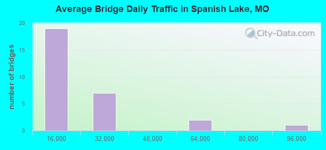
- 445,179Total average daily traffic
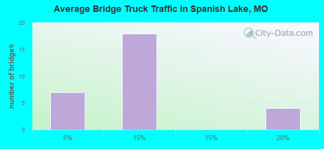
- 46,974Total average daily truck traffic
- National Bridge Inventory (NBI) Registered Bridges for Spanish Lake
- No street view available for this location
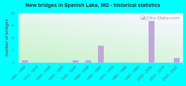
- New bridges - historical statistics
- 11900-1909
- 11940-1949
- 11950-1959
- 71960-1969
- 172000-2009
- 22020-2022
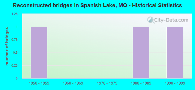
- Reconstructed bridges - Historical Statistics
- 11950-1959
- 01960-1969
- 01970-1979
- 11980-1989
- 11990-1999
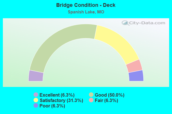
- Bridge Condition - Deck
- 6.3%Excellent
- 50.0%Good
- 31.3%Satisfactory
- 6.3%Fair
- 6.3%Poor
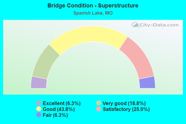
- Bridge Condition - Superstructure
- 6.3%Excellent
- 18.8%Very good
- 43.8%Good
- 25.0%Satisfactory
- 6.3%Fair
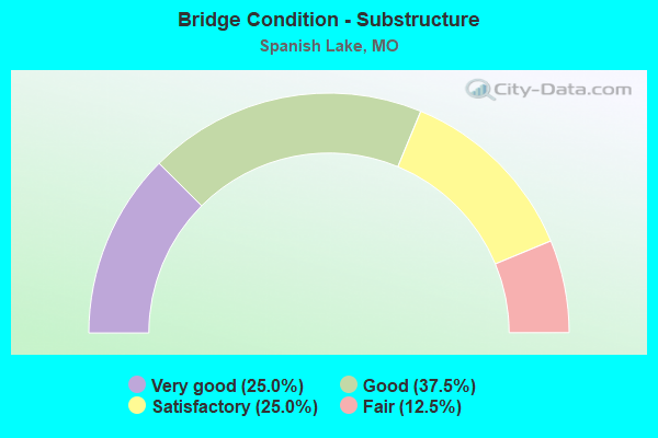
- Bridge Condition - Substructure
- 25.0%Very good
- 37.5%Good
- 25.0%Satisfactory
- 12.5%Fair
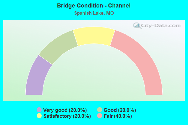
- Bridge Condition - Channel
- 20.0%Very good
- 20.0%Good
- 20.0%Satisfactory
- 40.0%Fair
Find on map >> Show street view
Structure Number: 15531, Location: S 36 T 47 N R 7 E (Lat: 38.772308, Lng: -90.185242), Route carried "on" structure: County highway , Year Built: 1902, Year Reconstructed: 1961, Status: Posted for load, Structure Length: 0.91m (2.99ft), Average Daily Traffic: 11 (year 2020), Truck Traffic: 7%, Average Future Daily Traffic: 15 (year 2040), Design Load: HS 20, Features Intersected: WATKINS CR, Facility Carried by Structure: COAL BANK RD
Minimum Vertical Clearance: 30+ m (98+ ft), Kilometerpoint: 1.448, Lanes on structure: 2, Owner: County Highway Agency, Approaching Roadway Width: 6.4m (21.0ft), Material/Design: Prestressed concrete, Design/Construction: Box Beam or Girders - Multiple, Number Of Spans In Main Unit: 1, Length of Maximum Span: 7.9m (25.9ft), Curb-To-Curb Width: 7.0m (23.0ft), Out-to-Out Width: 7.3m (24.0ft)
Condition: Deck: Satisfactory, Superstructure: Satisfactory, Substructure: Fair, Channel: Satisfactory, Operating Rating: 35.1 metric tons, Method Used To Determine Operating Rating: Allowable Stress (AS), Inventory Rating: 22.5 metric tons, Method Used To Determine Inventory Rating: Allowable Stress (AS), Structural Evaluation: Somewhat better than minimum adequacy, Deck Geometry: Somewhat better than minimum adequacy, Waterway Adequacy: Superior to present desirable criteria, Approach Roadway Alignment: Equal to present desirable criteria, Designated Inspection Frequency: Every 24 months, Inspection Date: April 2020, Deck Structure Type: Other, Wearing Surface/Protective System: Wearing Surface: Bituminous
Find on map >> Show street view
Structure Number: 15532, Location: S 36 T 47 N R 7 E (Lat: 38.774972, Lng: -90.182106), Route carried "on" structure: County highway , Year Built: 1947, Year Reconstructed: 1980, Status: Posted for load, Structure Length: 0.70m (2.30ft), Average Daily Traffic: 3,955 (year 2020), Truck Traffic: 3%, Average Future Daily Traffic: 5,339 (year 2040), Design Load: HS 20, Features Intersected: WATKINS CR, Facility Carried by Structure: RIVERVIEW DR
Minimum Vertical Clearance: 30+ m (98+ ft), Kilometerpoint: 0.000, Lanes on structure: 2, Owner: County Highway Agency, Approaching Roadway Width: 6.7m (22.0ft), Skew: 10 degrees, Material/Design: Prestressed concrete, Design/Construction: Box Beam or Girders - Multiple, Number Of Spans In Main Unit: 1, Length of Maximum Span: 6.7m (22.0ft), Curb-To-Curb Width: 7.0m (23.0ft), Out-to-Out Width: 7.3m (24.0ft)
Condition: Deck: Satisfactory, Superstructure: Satisfactory, Substructure: Fair, Channel: Fair, Operating Rating: 71.1 metric tons, Method Used To Determine Operating Rating: Allowable Stress (AS), Inventory Rating: 52.2 metric tons, Method Used To Determine Inventory Rating: Allowable Stress (AS), Structural Evaluation: Somewhat better than minimum adequacy, Deck Geometry: High priority of replacement, Waterway Adequacy: Somewhat better than minimum adequacy, Approach Roadway Alignment: Equal to present desirable criteria, Length Of Structure Improvement: 0.13m (0.43ft), Designated Inspection Frequency: Every 24 months, Inspection Date: April 2020, Bridge Improvement Cost: $140,000, Roadway Improvement Cost: $14,000, Total Project Cost: $211,000 ( Estimate for 2022), Deck Structure Type: Other, Wearing Surface/Protective System: Wearing Surface: Bituminous
Find on map >> Show street view
Structure Number: 15535, Location: S 28 T 47 N R 7 E (Lat: 38.784433, Lng: -90.237825), Route carried "on" structure: County highway , Year Built: 1957, Year Reconstructed: 1996, Status: Posted for load, Structure Length: 1.71m (5.61ft), Average Daily Traffic: 4,497 (year 2020), Truck Traffic: 5%, Average Future Daily Traffic: 6,071 (year 2040), Design Load: HS 25 or greater, Features Intersected: WATKINS CR, Facility Carried by Structure: REDMAN AVE
Minimum Vertical Clearance: 30+ m (98+ ft), Kilometerpoint: 2.092, Lanes on structure: 2, Owner: County Highway Agency, Approaching Roadway Width: 13.1m (43.0ft), Material/Design: Prestressed concrete, Design/Construction: Box Beam or Girders - Multiple, Number Of Spans In Main Unit: 1, Length of Maximum Span: 16.5m (54.1ft), Curb or Sidewalk Widths: Left: 1.4m (4.6ft), Right: 1.4m (4.6ft), Curb-To-Curb Width: 13.1m (43.0ft), Out-to-Out Width: 17.1m (56.1ft)
Condition: Deck: Good, Superstructure: Good, Substructure: Satisfactory, Channel: Fair, Operating Rating: 70.2 metric tons, Method Used To Determine Operating Rating: Load Factor (LF), Inventory Rating: 42.3 metric tons, Method Used To Determine Inventory Rating: Load Factor (LF), Structural Evaluation: Equal to present minimum criteria, Deck Geometry: Equal to present minimum criteria, Waterway Adequacy: Equal to present desirable criteria, Approach Roadway Alignment: Equal to present desirable criteria, Designated Inspection Frequency: Every 24 months, Inspection Date: Febuary 2020, Deck Structure Type: Other, Wearing Surface/Protective System: Wearing Surface: Bituminous, Membrane: Built-up
Find on map >> Show street view
Structure Number: 15537, Location: S 22 T 47 N R 7 E (Lat: 38.799650, Lng: -90.207925), Route carried "on" structure: County highway , Year Built: 1960, Status: Posted for load, Structure Length: 4.11m (13.48ft), Average Daily Traffic: 1,947 (year 2020), Truck Traffic: 3%, Average Future Daily Traffic: 2,628 (year 2040), Design Load: HS 20, Features Intersected: BNSF RR, Facility Carried by Structure: SPANISH POND RD
Minimum Vertical Clearance: 30+ m (98+ ft), Kilometerpoint: 2.736, Lanes on structure: 2, Owner: County Highway Agency, Approaching Roadway Width: 7.6m (24.9ft), Material/Design: Steel continuous, Design/Construction: Stringer/Multi-beam, Number Of Spans In Main Unit: 1, Number Of Approach Spans: 2, Length of Maximum Span: 15.5m (50.9ft), Curb or Sidewalk Widths: Left: 1.4m (4.6ft), Right: 0.0m, Curb-To-Curb Width: 7.3m (24.0ft), Out-to-Out Width: 9.1m (29.9ft)
Condition: Deck: Poor, Superstructure: Fair, Substructure: Satisfactory, Operating Rating: 35.1 metric tons, Method Used To Determine Operating Rating: Allowable Stress (AS), Inventory Rating: 22.5 metric tons, Method Used To Determine Inventory Rating: Allowable Stress (AS), Structural Evaluation: Somewhat better than minimum adequacy, Deck Geometry: Meets minimum limits, Underclear: Somewhat better than minimum adequacy, Approach Roadway Alignment: Equal to present minimum criteria, Length Of Structure Improvement: 0.51m (1.67ft), Designated Inspection Frequency: Every 24 months, Inspection Date: Febuary 2020, Bridge Improvement Cost: $375,000, Roadway Improvement Cost: $37,000, Total Project Cost: $562,000 ( Estimate for 2022), Deck Structure Type: Concrete Cast-file-Place, Wearing Surface/Protective System: Wearing Surface: Monolithic Concrete, Membrane: Epoxy
Find on map >> Show street view
Structure Number: 188, Location: S 35 T 47 N R 7 E (Lat: 38.767225, Lng: -90.202928), Route carried "on" structure: County highway , Year Built: 1961, Status: Posted for load, Structure Length: 6.34m (20.80ft), Average Daily Traffic: 9,910 (year 2021), Truck Traffic: 4%, Average Future Daily Traffic: 14,865 (year 2041), Design Load: H 20, Features Intersected: IS 270, Facility Carried by Structure: LILAC AVE S
Minimum Vertical Clearance: 30+ m (98+ ft), Kilometerpoint: 0.967, Lanes on structure: 4, Lanes under structure: 4, Owner: State Highway Agency, Approaching Roadway Width: 14.6m (47.9ft), Material/Design: Concrete continuous, Design/Construction: Slab, Number Of Spans In Main Unit: 4, Length of Maximum Span: 16.8m (55.1ft), Curb-To-Curb Width: 15.8m (51.8ft), Out-to-Out Width: 19.4m (63.6ft)
Condition: Deck: Satisfactory, Superstructure: Satisfactory, Substructure: Satisfactory, Operating Rating: 43.2 metric tons, Method Used To Determine Operating Rating: Allowable Stress (AS), Inventory Rating: 21.6 metric tons, Method Used To Determine Inventory Rating: Allowable Stress (AS), Structural Evaluation: Somewhat better than minimum adequacy, Deck Geometry: Meets minimum limits, Underclear: Somewhat better than minimum adequacy, Approach Roadway Alignment: Equal to present desirable criteria, Designated Inspection Frequency: Every 24 months, Inspection Date: August 2020, Deck Structure Type: Concrete Cast-file-Place, Wearing Surface/Protective System: Wearing Surface: Latex Concrete
Find on map >> Show street view
Structure Number: 28587, Location: S 15 T 47 N R 7 E (Lat: 38.812253, Lng: -90.216781), Route carried "on" structure: County highway , Year Built: 2004, Status: Posted for load, Structure Length: 6.25m (20.51ft), Average Daily Traffic: 792 (year 2020), Truck Traffic: 5%, Average Future Daily Traffic: 1,069 (year 2040), Design Load: HS 25 or greater, Features Intersected: BNSF RR, Facility Carried by Structure: BELLEFONTAINE RD
Minimum Vertical Clearance: 30+ m (98+ ft), Kilometerpoint: 5.150, Lanes on structure: 2, Owner: County Highway Agency, Approaching Roadway Width: 9.1m (29.9ft), Skew: 4 degrees, Material/Design: Prestressed concrete, Design/Construction: Stringer/Multi-beam, Number Of Spans In Main Unit: 3, Length of Maximum Span: 19.2m (63.0ft), Curb-To-Curb Width: 9.2m (30.2ft), Out-to-Out Width: 10.0m (32.8ft)
Condition: Deck: Good, Superstructure: Good, Substructure: Very good, Operating Rating: 70.2 metric tons, Method Used To Determine Operating Rating: Load Factor (LF), Inventory Rating: 42.3 metric tons, Method Used To Determine Inventory Rating: Load Factor (LF), Structural Evaluation: Better than present minimum criteria, Deck Geometry: Equal to present minimum criteria, Underclear: Somewhat better than minimum adequacy, Approach Roadway Alignment: Equal to present desirable criteria, Designated Inspection Frequency: Every 24 months, Inspection Date: Febuary 2020, Deck Structure Type: Concrete Precast Panels, Wearing Surface/Protective System: Wearing Surface: Monolithic Concrete, Membrane: Epoxy, Deck Protection: Epoxy Coated Reinforcing
Find on map >> Show street view
Structure Number: 29012, Location: S 16 T 47 N R 7 E (Lat: 38.814672, Lng: -90.229578), Route carried "on" structure: State highway 367, Year Built: 2002, Status: Open, Structure Length: 5.55m (18.21ft), Average Daily Traffic: 4,569 (year 2021), Truck Traffic: 5%, Average Future Daily Traffic: 5,711 (year 2041), Design Load: HS 20+Mod, Features Intersected: COLDWATER CR
Minimum Vertical Clearance: 30+ m (98+ ft), Kilometerpoint: 13.762, Lanes on structure: 2, Base Highway Network: Yes, Owner: State Highway Agency, Approaching Roadway Width: 11.6m (38.1ft), Material/Design: Prestressed concrete continuous, Design/Construction: Stringer/Multi-beam, Number Of Spans In Main Unit: 3, Length of Maximum Span: 21.3m (69.9ft), Curb-To-Curb Width: 11.6m (38.1ft), Out-to-Out Width: 12.4m (40.7ft)
Condition: Deck: Good, Superstructure: Very good, Substructure: Good, Channel: Very good, Operating Rating: 71.1 metric tons, Method Used To Determine Operating Rating: Load Factor (LF), Inventory Rating: 42.3 metric tons, Method Used To Determine Inventory Rating: Load Factor (LF), Structural Evaluation: Better than present minimum criteria, Deck Geometry: Equal to present minimum criteria, Waterway Adequacy: Superior to present desirable criteria, Approach Roadway Alignment: Equal to present desirable criteria, Designated Inspection Frequency: Every 24 months, Inspection Date: August 2020, Deck Structure Type: Concrete Cast-file-Place, Wearing Surface/Protective System: Wearing Surface: Monolithic Concrete, Deck Protection: Epoxy Coated Reinforcing
Find on map >> Show street view
Structure Number: 30591, Location: S 9 T 46 N R 7 E (Lat: 38.740828, Lng: -90.240594), Route carried "on" structure: State highway 367, Year Built: 2005, Status: Open, Structure Length: 4.91m (16.11ft), Average Daily Traffic: 23,497 (year 2021), Truck Traffic: 6%, Average Future Daily Traffic: 32,896 (year 2041), Design Load: HS 20, Features Intersected: MALINE CR
Minimum Vertical Clearance: 30+ m (98+ ft), Kilometerpoint: 8.938, Lanes on structure: 4, Base Highway Network: Yes, Owner: State Highway Agency, Approaching Roadway Width: 21.0m (68.9ft), Skew: 2 degrees, Material/Design: Prestressed concrete continuous, Design/Construction: Stringer/Multi-beam, Number Of Spans In Main Unit: 3, Length of Maximum Span: 18.6m (61.0ft), Curb-To-Curb Width: 21.0m (68.9ft), Out-to-Out Width: 21.8m (71.5ft)
Condition: Deck: Satisfactory, Superstructure: Good, Substructure: Good, Channel: Good, Operating Rating: 83.7 metric tons, Method Used To Determine Operating Rating: Load Factor (LF), Inventory Rating: 49.5 metric tons, Method Used To Determine Inventory Rating: Load Factor (LF), Structural Evaluation: Better than present minimum criteria, Deck Geometry: Superior to present desirable criteria, Waterway Adequacy: Superior to present desirable criteria, Approach Roadway Alignment: Equal to present desirable criteria, Designated Inspection Frequency: Every 24 months, Inspection Date: August 2020, Deck Structure Type: Concrete Cast-file-Place, Wearing Surface/Protective System: Wearing Surface: Monolithic Concrete, Deck Protection: Epoxy Coated Reinforcing
Find on map >> Show street view
Structure Number: 31085, Location: S 21 T 47 N R 7 E (Lat: 38.795686, Lng: -90.230258), Route carried "on" structure: State highway 367, Year Built: 2005, Status: Open, Structure Length: 9.27m (30.41ft), Average Daily Traffic: 24,693 (year 2021), Truck Traffic: 5%, Average Future Daily Traffic: 30,866 (year 2041), Design Load: HS 20, Features Intersected: CRD PARKER RD, OR TO LUS
Minimum Vertical Clearance: 30+ m (98+ ft), Kilometerpoint: 2.700, Lanes on structure: 4, Lanes under structure: 6, Base Highway Network: Yes, Owner: State Highway Agency, Approaching Roadway Width: 28.0m (91.9ft), Skew: 30 degrees, Material/Design: Steel continuous, Design/Construction: Stringer/Multi-beam, Number Of Spans In Main Unit: 3, Length of Maximum Span: 33.2m (108.9ft), Curb-To-Curb Width: 28.0m (91.9ft), Out-to-Out Width: 29.5m (96.8ft)
Condition: Deck: Good, Superstructure: Good, Substructure: Very good, Operating Rating: 68.4 metric tons, Method Used To Determine Operating Rating: Load Factor (LF), Inventory Rating: 40.5 metric tons, Method Used To Determine Inventory Rating: Load Factor (LF), Structural Evaluation: Better than present minimum criteria, Deck Geometry: Superior to present desirable criteria, Approach Roadway Alignment: Better than present minimum criteria, Designated Inspection Frequency: Every 24 months, Inspection Date: August 2020, Deck Structure Type: Concrete Cast-file-Place, Wearing Surface/Protective System: Wearing Surface: Monolithic Concrete, Deck Protection: Epoxy Coated Reinforcing
Find on map >> Show street view
Structure Number: 31092, Location: S 28 T 47 N R 7 E (Lat: 38.785383, Lng: -90.234306), Route carried "on" structure: State highway 367, Year Built: 2005, Status: Open, Structure Length: 17.56m (57.61ft), Average Daily Traffic: 24,777 (year 2021), Truck Traffic: 5%, Average Future Daily Traffic: 30,971 (year 2041), Design Load: HS 20, Features Intersected: CRD REDMAN RD, OR TO LUS
Minimum Vertical Clearance: 5.33m (17.49ft), Kilometerpoint: 10.408, Lanes on structure: 3, Lanes under structure: 6, Base Highway Network: Yes, Owner: State Highway Agency, Approaching Roadway Width: 17.7m (58.1ft), Skew: 3 degrees, Material/Design: Steel continuous, Design/Construction: Stringer/Multi-beam, Number Of Spans In Main Unit: 5, Length of Maximum Span: 44.2m (145.0ft), Curb-To-Curb Width: 17.5m (57.4ft), Out-to-Out Width: 18.3m (60.0ft)
Condition: Deck: Good, Superstructure: Very good, Substructure: Good, Operating Rating: 59.4 metric tons, Method Used To Determine Operating Rating: Load Factor (LF), Inventory Rating: 36.0 metric tons, Method Used To Determine Inventory Rating: Load Factor (LF), Structural Evaluation: Better than present minimum criteria, Deck Geometry: Better than present minimum criteria, Underclear: Meets minimum limits, Approach Roadway Alignment: Better than present minimum criteria, Designated Inspection Frequency: Every 24 months, Inspection Date: August 2020, Deck Structure Type: Concrete Cast-file-Place, Wearing Surface/Protective System: Wearing Surface: Monolithic Concrete, Deck Protection: Epoxy Coated Reinforcing
Find on map >> Show street view
Structure Number: 31093, Location: S 28 T 47 N R 7 E (Lat: 38.785317, Lng: -90.234539), Route carried "on" structure: State highway 367, Year Built: 2005, Status: Open, Structure Length: 17.56m (57.61ft), Average Daily Traffic: 20,887 (year 2021), Truck Traffic: 5%, Average Future Daily Traffic: 26,109 (year 2041), Design Load: HS 20, Features Intersected: CRD REDMAN RD, OR TO LUS
Minimum Vertical Clearance: 5.33m (17.49ft), Kilometerpoint: 3.869, Lanes on structure: 3, Lanes under structure: 6, Base Highway Network: Yes, Owner: State Highway Agency, Approaching Roadway Width: 17.7m (58.1ft), Skew: 3 degrees, Material/Design: Steel continuous, Design/Construction: Stringer/Multi-beam, Number Of Spans In Main Unit: 5, Length of Maximum Span: 44.2m (145.0ft), Curb-To-Curb Width: 17.5m (57.4ft), Out-to-Out Width: 18.3m (60.0ft)
Condition: Deck: Good, Superstructure: Excellent, Substructure: Good, Operating Rating: 59.4 metric tons, Method Used To Determine Operating Rating: Load Factor (LF), Inventory Rating: 36.0 metric tons, Method Used To Determine Inventory Rating: Load Factor (LF), Structural Evaluation: Better than present minimum criteria, Deck Geometry: Better than present minimum criteria, Underclear: Meets minimum limits, Approach Roadway Alignment: Better than present minimum criteria, Designated Inspection Frequency: Every 24 months, Inspection Date: August 2020, Deck Structure Type: Concrete Cast-file-Place, Wearing Surface/Protective System: Wearing Surface: Monolithic Concrete, Deck Protection: Epoxy Coated Reinforcing
Find on map >> Show street view
Structure Number: 31095, Location: S 28 T 47 N R 7 E (Lat: 38.779164, Lng: -90.236950), Route carried "on" structure: State highway 367, Year Built: 2005, Status: Open, Structure Length: 6.04m (19.82ft), Average Daily Traffic: 49,974 (year 2021), Truck Traffic: 5%, Average Future Daily Traffic: 62,468 (year 2041), Design Load: HS 20, Features Intersected: OR 270, OR TO LUSHER RD
Minimum Vertical Clearance: 30+ m (98+ ft), Kilometerpoint: 4.632, Lanes on structure: 4, Lanes under structure: 5, Base Highway Network: Yes, Owner: State Highway Agency, Approaching Roadway Width: 14.0m (45.9ft), Skew: 30 degrees, Material/Design: Steel continuous, Design/Construction: Stringer/Multi-beam, Number Of Spans In Main Unit: 2, Length of Maximum Span: 34.7m (113.8ft), Curb-To-Curb Width: 28.0m (91.9ft), Out-to-Out Width: 29.5m (96.8ft)
Condition: Deck: Satisfactory, Superstructure: Good, Substructure: Good, Operating Rating: 73.8 metric tons, Method Used To Determine Operating Rating: Load Factor (LF), Inventory Rating: 44.1 metric tons, Method Used To Determine Inventory Rating: Load Factor (LF), Structural Evaluation: Better than present minimum criteria, Deck Geometry: Superior to present desirable criteria, Underclear: Meets minimum limits, Approach Roadway Alignment: Equal to present desirable criteria, Designated Inspection Frequency: Every 24 months, Inspection Date: August 2020, Deck Structure Type: Concrete Cast-file-Place, Wearing Surface/Protective System: Wearing Surface: Monolithic Concrete, Deck Protection: Epoxy Coated Reinforcing
Find on map >> Show street view
Structure Number: 31606, Location: S 16 T 47 N R 7 E (Lat: 38.809533, Lng: -90.228192), Route carried "on" structure: County highway , Year Built: 2006, Status: Open, Structure Length: 3.32m (10.89ft), Average Daily Traffic: 2,613 (year 2021), Truck Traffic: 4%, Average Future Daily Traffic: 3,920 (year 2041), Design Load: HS 25 or greater, Features Intersected: MO 367, Facility Carried by Structure: NEW JAMESTOWN RD E
Minimum Vertical Clearance: 30+ m (98+ ft), Kilometerpoint: 0.019, Lanes on structure: 4, Lanes under structure: 4, Owner: State Highway Agency, Approaching Roadway Width: 19.5m (64.0ft), Material/Design: Prestressed concrete continuous, Design/Construction: Stringer/Multi-beam, Number Of Spans In Main Unit: 2, Length of Maximum Span: 16.2m (53.1ft), Curb or Sidewalk Widths: Left: 1.8m (5.9ft), Right: 0.0m, Curb-To-Curb Width: 19.5m (64.0ft), Out-to-Out Width: 20.3m (66.6ft)
Condition: Deck: Good, Superstructure: Good, Substructure: Very good, Operating Rating: 82.8 metric tons, Method Used To Determine Operating Rating: Load Factor (LF), Inventory Rating: 49.5 metric tons, Method Used To Determine Inventory Rating: Load Factor (LF), Structural Evaluation: Better than present minimum criteria, Deck Geometry: Better than present minimum criteria, Underclear: High priority of corrective action, Approach Roadway Alignment: Equal to present desirable criteria, Designated Inspection Frequency: Every 48 months, Inspection Date: August 2020, Deck Structure Type: Concrete Cast-file-Place, Wearing Surface/Protective System: Wearing Surface: Epoxy Overlay, Deck Protection: Epoxy Coated Reinforcing
Find on map >> Show street view
Structure Number: 31613, Location: S 16 T 47 N R 7 E (Lat: 38.809367, Lng: -90.228172), Route carried "on" structure: Ramp State highway , Year Built: 2006, Status: Open, Structure Length: 3.38m (11.09ft), Average Daily Traffic: 1,501 (year 2021), Truck Traffic: 5%, Average Future Daily Traffic: 1,876 (year 2041), Design Load: HS 25 or greater, Features Intersected: MO 367, Facility Carried by Structure: RP EOR367 TO MO367
Minimum Vertical Clearance: 30+ m (98+ ft), Kilometerpoint: 0.045, Lanes on structure: 1, Lanes under structure: 4, Base Highway Network: Yes, Owner: State Highway Agency, Approaching Roadway Width: 8.5m (27.9ft), Material/Design: Prestressed concrete continuous, Design/Construction: Stringer/Multi-beam, Number Of Spans In Main Unit: 2, Length of Maximum Span: 16.2m (53.1ft), Curb-To-Curb Width: 15.2m (49.9ft), Out-to-Out Width: 16.1m (52.8ft)
Condition: Deck: Good, Superstructure: Good, Substructure: Good, Operating Rating: 80.1 metric tons, Method Used To Determine Operating Rating: Load Factor (LF), Inventory Rating: 45.0 metric tons, Method Used To Determine Inventory Rating: Load Factor (LF), Structural Evaluation: Better than present minimum criteria, Deck Geometry: Superior to present desirable criteria, Underclear: High priority of corrective action, Approach Roadway Alignment: Equal to present desirable criteria, Designated Inspection Frequency: Every 48 months, Inspection Date: August 2020, Deck Structure Type: Concrete Cast-file-Place, Wearing Surface/Protective System: Wearing Surface: Epoxy Overlay, Deck Protection: Epoxy Coated Reinforcing
Find on map >> Show street view
Structure Number: 36415, Location: S 32 T 47 N R 7 E (Lat: 38.770731, Lng: -90.245139), Route carried "on" structure: ServiceState highway 270, Year Built: 2020, Status: Open, Structure Length: 5.23m (17.16ft), Average Daily Traffic: 2,805 (year 2021), Truck Traffic: 3%, Average Future Daily Traffic: 4,208 (year 2041), Features Intersected: IS 270
Minimum Vertical Clearance: 30+ m (98+ ft), Kilometerpoint: 1.349, Lanes on structure: 2, Lanes under structure: 10, Owner: State Highway Agency, Approaching Roadway Width: 12.7m (41.7ft), Material/Design: Prestressed concrete continuous, Design/Construction: Tee Beam, Number Of Spans In Main Unit: 2, Length of Maximum Span: 25.6m (84.0ft), Curb or Sidewalk Widths: Left: 0.0m, Right: 2.6m (8.5ft), Curb-To-Curb Width: 12.7m (41.7ft), Out-to-Out Width: 16.1m (52.8ft)
Condition: Deck: Excellent, Superstructure: Very good, Substructure: Very good, Operating Rating: 67.5 metric tons, Method Used To Determine Operating Rating: Load Factor (LF), Inventory Rating: 40.5 metric tons, Method Used To Determine Inventory Rating: Load Factor (LF), Structural Evaluation: Equal to present desirable criteria, Deck Geometry: Equal to present minimum criteria, Underclear: High priority of corrective action, Approach Roadway Alignment: Somewhat better than minimum adequacy, Designated Inspection Frequency: Every 24 months, Inspection Date: August 2021, Deck Structure Type: Concrete Cast-file-Place, Wearing Surface/Protective System: Wearing Surface: Monolithic Concrete, Deck Protection: Epoxy Coated Reinforcing
Find on map >> Show street view
Structure Number: 5554, Location: S 33 T 47 N R 7 E (Lat: 38.770689, Lng: -90.238831), Route carried "on" structure: Interstate 270, Year Built: 1961, Status: Posted for load, Structure Length: 6.10m (20.01ft), Average Daily Traffic: 89,021 (year 2021), Truck Traffic: 18%, Average Future Daily Traffic: 111,276 (year 2041), Design Load: HS 20+Mod, Features Intersected: MO 367
Minimum Vertical Clearance: 30+ m (98+ ft), Kilometerpoint: 51.638, Lanes on structure: 8, Lanes under structure: 6, Base Highway Network: Yes, Owner: State Highway Agency, Approaching Roadway Width: 32.6m (107.0ft), Skew: 30 degrees, Material/Design: Steel continuous, Design/Construction: Stringer/Multi-beam, Number Of Spans In Main Unit: 4, Length of Maximum Span: 15.8m (51.8ft), Curb or Sidewalk Widths: Left: 0.2m (0.7ft), Right: 0.2m (0.7ft), Curb-To-Curb Width: 32.6m (107.0ft), Out-to-Out Width: 34.4m (112.9ft)
Condition: Deck: Fair, Superstructure: Satisfactory, Substructure: Satisfactory, Operating Rating: 47.7 metric tons, Method Used To Determine Operating Rating: Load Factor (LF), Inventory Rating: 28.8 metric tons, Method Used To Determine Inventory Rating: Load Factor (LF), Structural Evaluation: Equal to present minimum criteria, Deck Geometry: Meets minimum limits, Underclear: High priority of corrective action, Approach Roadway Alignment: Equal to present desirable criteria, Designated Inspection Frequency: Every 24 months, Inspection Date: August 2020, Deck Structure Type: Concrete Cast-file-Place, Wearing Surface/Protective System: Wearing Surface: Other, Membrane: Built-up
Find on map >> Show street view
Structure Number: 188, Location: S 35 T 47 N R 7 E (Lat: 38.767225, Lng: -90.202928), Route carried "under" structure: Interstate 270, Year Built: 1961, Structure Length: 0. m, Average Daily Traffic: 28,433 (year 2021), Truck Traffic: 18%, Features Intersected: IS 270, Facility Carried by Structure: LILAC AVE S
Minimum Vertical Clearance: 5.23m (17.16ft), Kilometerpoint: 54.814, Lanes on structure: 4, Lanes under structure: 2, Material/Design: Concrete continuous, Design/Construction: Slab, Length of Maximum Span: 16.8m (55.1ft)
Find on map >> Show street view
Structure Number: 188, Location: S 35 T 47 N R 7 E (Lat: 38.767225, Lng: -90.202928), Route carried "under" structure: Interstate 270, Year Built: 1961, Structure Length: 0. m, Average Daily Traffic: 24,154 (year 2021), Truck Traffic: 18%, Features Intersected: IS 270, Facility Carried by Structure: LILAC AVE S
Minimum Vertical Clearance: 6.30m (20.67ft), Kilometerpoint: 2.739, Lanes on structure: 4, Lanes under structure: 2, Material/Design: Concrete continuous, Design/Construction: Slab, Length of Maximum Span: 16.8m (55.1ft)
Find on map >> Show street view
Structure Number: 31085, Location: S 21 T 47 N R 7 E (Lat: 38.795686, Lng: -90.230258), Route carried "under" structure: County highway , Year Built: 2005, Structure Length: 0. m, Average Daily Traffic: 9,035 (year 2021), Truck Traffic: 5%, Features Intersected: CRD PARKER RD, Facility Carried by Structure: MO 367 S
Minimum Vertical Clearance: 5.28m (17.32ft), Kilometerpoint: 3.417, Lanes on structure: 4, Lanes under structure: 4, Material/Design: Steel continuous, Design/Construction: Stringer/Multi-beam, Length of Maximum Span: 33.2m (108.9ft)
Find on map >> Show street view
Structure Number: 31092, Location: S 28 T 47 N R 7 E (Lat: 38.785383, Lng: -90.234306), Route carried "under" structure: County highway , Year Built: 2005, Structure Length: 0. m, Average Daily Traffic: 5,998 (year 2021), Truck Traffic: 5%, Features Intersected: CRD REDMAN RD, Facility Carried by Structure: MO 367 N
Minimum Vertical Clearance: 4.93m (16.17ft), Kilometerpoint: 2.860, Lanes on structure: 3, Lanes under structure: 4, Material/Design: Steel continuous, Design/Construction: Stringer/Multi-beam, Length of Maximum Span: 44.2m (145.0ft)
Find on map >> Show street view
Structure Number: 31093, Location: S 28 T 47 N R 7 E (Lat: 38.785317, Lng: -90.234539), Route carried "under" structure: County highway , Year Built: 2005, Structure Length: 0. m, Average Daily Traffic: 5,555 (year 2021), Truck Traffic: 6%, Features Intersected: CRD REDMAN RD, Facility Carried by Structure: MO 367 S
Minimum Vertical Clearance: 4.75m (15.58ft), Kilometerpoint: 2.826, Lanes on structure: 3, Lanes under structure: 4, Material/Design: Steel continuous, Design/Construction: Stringer/Multi-beam, Length of Maximum Span: 44.2m (145.0ft)
Find on map >> Show street view
Structure Number: 31095, Location: S 28 T 47 N R 7 E (Lat: 38.779164, Lng: -90.236950), Route carried "under" structure: ServiceState highway 270, Year Built: 2005, Structure Length: 0. m, Average Daily Traffic: 1,800 (year 2021), Truck Traffic: 4%, Features Intersected: OR 270, Facility Carried by Structure: MO 367 S
Minimum Vertical Clearance: 4.85m (15.91ft), Kilometerpoint: 2.103, Lanes on structure: 4, Lanes under structure: 4, Material/Design: Steel continuous, Design/Construction: Stringer/Multi-beam, Length of Maximum Span: 34.7m (113.8ft)
Find on map >> Show street view
Structure Number: 31606, Location: S 16 T 47 N R 7 E (Lat: 38.809533, Lng: -90.228192), Route carried "under" structure: State highway 367, Year Built: 2006, Structure Length: 0. m, Average Daily Traffic: 4,569 (year 2021), Truck Traffic: 5%, Features Intersected: MO 367, Facility Carried by Structure: NEW JAMESTOWN RD E
Minimum Vertical Clearance: 5.08m (16.67ft), Kilometerpoint: 13.242, Lanes on structure: 4, Lanes under structure: 2, Material/Design: Prestressed concrete continuous, Design/Construction: Stringer/Multi-beam, Length of Maximum Span: 16.2m (53.1ft)
Find on map >> Show street view
Structure Number: 31606, Location: S 16 T 47 N R 7 E (Lat: 38.809533, Lng: -90.228192), Route carried "under" structure: State highway 367, Year Built: 2006, Structure Length: 0. m, Average Daily Traffic: 4,087 (year 2021), Truck Traffic: 5%, Features Intersected: MO 367, Facility Carried by Structure: NEW JAMESTOWN RD E
Minimum Vertical Clearance: 5.08m (16.67ft), Kilometerpoint: 1.181, Lanes on structure: 4, Lanes under structure: 2, Material/Design: Prestressed concrete continuous, Design/Construction: Stringer/Multi-beam, Length of Maximum Span: 16.2m (53.1ft)
Find on map >> Show street view
Structure Number: 31613, Location: S 16 T 47 N R 7 E (Lat: 38.809367, Lng: -90.228172), Route carried "under" structure: State highway 367, Year Built: 2006, Structure Length: 0. m, Average Daily Traffic: 4,087 (year 2021), Truck Traffic: 5%, Features Intersected: MO 367
Minimum Vertical Clearance: 5.11m (16.77ft), Kilometerpoint: 1.210, Lanes on structure: 1, Lanes under structure: 2, Material/Design: Prestressed concrete continuous, Design/Construction: Stringer/Multi-beam, Length of Maximum Span: 16.2m (53.1ft)
Find on map >> Show street view
Structure Number: 31613, Location: S 16 T 47 N R 7 E (Lat: 38.809367, Lng: -90.228172), Route carried "under" structure: State highway 367, Year Built: 2006, Structure Length: 0. m, Average Daily Traffic: 4,569 (year 2021), Truck Traffic: 5%, Features Intersected: MO 367
Minimum Vertical Clearance: 5.11m (16.77ft), Kilometerpoint: 13.213, Lanes on structure: 1, Lanes under structure: 2, Material/Design: Prestressed concrete continuous, Design/Construction: Stringer/Multi-beam, Length of Maximum Span: 16.2m (53.1ft)
Find on map >> Show street view
Structure Number: 36415, Location: S 32 T 47 N R 7 E (Lat: 38.770731, Lng: -90.245139), Route carried "under" structure: Interstate 270, Year Built: 2020, Structure Length: 0. m, Average Daily Traffic: 51,345 (year 2021), Truck Traffic: 18%, Features Intersected: IS 270
Minimum Vertical Clearance: 5.06m (16.60ft), Kilometerpoint: 6.453, Lanes on structure: 2, Lanes under structure: 5, Material/Design: Prestressed concrete continuous, Design/Construction: Tee Beam, Length of Maximum Span: 25.6m (84.0ft)
Find on map >> Show street view
Structure Number: 5554, Location: S 33 T 47 N R 7 E (Lat: 38.770689, Lng: -90.238831), Route carried "under" structure: State highway 367, Year Built: 1961, Structure Length: 0. m, Average Daily Traffic: 25,197 (year 2021), Truck Traffic: 5%, Features Intersected: MO 367, Facility Carried by Structure: IS 270 E
Minimum Vertical Clearance: 4.70m (15.42ft), Kilometerpoint: 5.642, Lanes on structure: 8, Lanes under structure: 3, Material/Design: Steel continuous, Design/Construction: Stringer/Multi-beam, Length of Maximum Span: 15.8m (51.8ft)
Find on map >> Show street view
Structure Number: 5554, Location: S 33 T 47 N R 7 E (Lat: 38.770689, Lng: -90.238831), Route carried "under" structure: State highway 367, Year Built: 1961, Structure Length: 0. m, Average Daily Traffic: 10,901 (year 2021), Truck Traffic: 2%, Features Intersected: MO 367, Facility Carried by Structure: IS 270 E
Minimum Vertical Clearance: 4.65m (15.26ft), Kilometerpoint: 8.776, Lanes on structure: 8, Lanes under structure: 3, Material/Design: Steel continuous, Design/Construction: Stringer/Multi-beam, Length of Maximum Span: 15.8m (51.8ft)