Bridge Statistics for Sparks, Georgia (GA)
Condition, Traffic, Stress, Structural Evaluation, Project Costs
- National Bridge Inventory (NBI) Statistics
- 15Number of bridges
- 167ft / 50.7mTotal length
- $11,567,000Total costs
- 206,140Total average daily traffic
- 9,475Total average daily truck traffic
- National Bridge Inventory (NBI) Registered Bridges for Sparks
- No street view available for this location
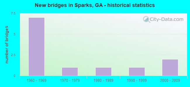
- New bridges - historical statistics
- 71960-1969
- 11970-1979
- 11980-1989
- 11990-1999
- 22000-2009


- Bridge Condition - Deck
- 87.5%Good
- 12.5%Satisfactory

- Bridge Condition - Superstructure
- 37.5%Very good
- 62.5%Good

- Bridge Condition - Substructure
- 87.5%Good
- 12.5%Critical

- Bridge Condition - Channel
- 14.3%Very good
- 28.6%Good
- 42.9%Satisfactory
- 14.3%Fair

- Bridge Condition - Culverts
- 75.0%Good
- 25.0%Satisfactory
Find on map >> Show street view
Structure Number: 75003, Location: APP 12 MI SW OF NEWTON (Lat: 31.190358, Lng: -84.486039), Route carried "on" structure: County highway 47, Year Built: 1960, Status: Posted for load, Structure Length: 3.66m (12.01ft), Average Daily Traffic: 50 (year 2011), Truck Traffic: 1%, Average Future Daily Traffic: 75 (year 2031), Features Intersected: BIG CYPRESS CREEK, Facility Carried by Structure: HOGGARD MILL RD
Minimum Vertical Clearance: 30+ m (98+ ft), Kilometerpoint: 3.219, Lanes on structure: 2, Base Highway Network: Yes, Owner: County Highway Agency, Approaching Roadway Width: 6.1m (20.0ft), Material/Design: Concrete, Design/Construction: Slab, Number Of Spans In Main Unit: 8, Length of Maximum Span: 4.6m (15.1ft), Curb-To-Curb Width: 6.7m (22.0ft), Out-to-Out Width: 7.0m (23.0ft)
Condition: Deck: Good, Superstructure: Good, Substructure: Critical, Channel: Satisfactory, Structural Evaluation: High priority of replacement, Deck Geometry: Somewhat better than minimum adequacy, Waterway Adequacy: Equal to present desirable criteria, Approach Roadway Alignment: Better than present minimum criteria, Bridge Posting: Required (Relationship of Operating Rating to Maximum Legal Load: > 39.9% below), Length Of Structure Improvement: 10.09m (33.10ft), Designated Inspection Frequency: Every 24 months, Inspection Date: January 2021, Bridge Improvement Cost: $469,000, Roadway Improvement Cost: $47,000, Total Project Cost: $703,000, Deck Structure Type: Concrete Precast Panels
Find on map >> Show street view
Structure Number: 750015, Location: 3.5 MI N OF SPARKS (Lat: 31.214969, Lng: -83.459928), Route carried "on" structure: County highway 253, Year Built: 1960, Status: Open, Structure Length: 6.00m (19.69ft), Average Daily Traffic: 940 (year 2011), Truck Traffic: 1%, Average Future Daily Traffic: 1,410 (year 2031), Design Load: HS 20+Mod, Features Intersected: I-75 (EXIT 45), Facility Carried by Structure: BARNEYVILLE ROAD
Minimum Vertical Clearance: 30+ m (98+ ft), Kilometerpoint: 6.437, Lanes on structure: 2, Lanes under structure: 6, Base Highway Network: Yes, Owner: State Highway Agency, Approaching Roadway Width: 6.1m (20.0ft), Skew: 1 degrees, Material/Design: Prestressed concrete, Design/Construction: Stringer/Multi-beam, Number Of Spans In Main Unit: 4, Length of Maximum Span: 18.3m (60.0ft), Curb or Sidewalk Widths: Left: 0.9m (3.0ft), Right: 0.9m (3.0ft), Curb-To-Curb Width: 8.5m (27.9ft), Out-to-Out Width: 10.5m (34.4ft)
Condition: Deck: Good, Superstructure: Good, Substructure: Good, Operating Rating: 49.8 metric tons, Method Used To Determine Operating Rating: Allowable Stress (AS), Inventory Rating: 32.6 metric tons, Method Used To Determine Inventory Rating: Allowable Stress (AS), Structural Evaluation: Better than present minimum criteria, Deck Geometry: Somewhat better than minimum adequacy, Underclear: High priority of corrective action, Approach Roadway Alignment: Somewhat better than minimum adequacy, Designated Inspection Frequency: Every 24 months, Inspection Date: October 2020, Other Special Inspection Date: November 2020, Bridge Improvement Cost: $766,000, Roadway Improvement Cost: $77,000, Total Project Cost: $1,149,000, Deck Structure Type: Concrete Cast-file-Place
Find on map >> Show street view
Structure Number: 750023, Location: IN SOUTH WEST SPARKS (Lat: 31.157775, Lng: -83.446922), Route carried "on" structure: Interstate 75, Year Built: 1960, Year Reconstructed: 2007, Status: Open, Structure Length: 1.43m (4.69ft), Average Daily Traffic: 34,110 (year 2011), Truck Traffic: 1%, Average Future Daily Traffic: 51,165 (year 2031), Design Load: HS 20+Mod, Features Intersected: GIDDENS MILL CREEK
Minimum Vertical Clearance: 30+ m (98+ ft), Kilometerpoint: 65.983, Lanes on structure: 4, Base Highway Network: Yes, Owner: State Highway Agency, Approaching Roadway Width: 37.2m (122.0ft), Skew: 30 degrees, Material/Design: Concrete, Design/Construction: Culvert, Number Of Spans In Main Unit: 6, Length of Maximum Span: 2.1m (6.9ft)
Condition: Channel: Very good, Culverts: Good, Operating Rating: 55.3 metric tons, Method Used To Determine Operating Rating: Field evaluation and documented engineering judgment, Inventory Rating: 32.6 metric tons, Method Used To Determine Inventory Rating: Field evaluation and documented engineering judgment, Structural Evaluation: Better than present minimum criteria, Waterway Adequacy: Equal to present minimum criteria, Approach Roadway Alignment: Equal to present minimum criteria, Designated Inspection Frequency: Every 24 months, Inspection Date: October 2020, Bridge Improvement Cost: $284,000, Roadway Improvement Cost: $28,000, Total Project Cost: $426,000
Find on map >> Show street view
Structure Number: 750029, Location: IN WEST SPARKS (Lat: 31.165903, Lng: -83.449350), Route carried "on" structure: County highway 1211, Year Built: 1960, Status: Open, Structure Length: 5.73m (18.80ft), Average Daily Traffic: 2,150 (year 2011), Truck Traffic: 1%, Average Future Daily Traffic: 3,225 (year 2031), Design Load: HS 20+Mod, Features Intersected: I-75 (EXIT 41), Facility Carried by Structure: ROUNDTREE BR. RD
Minimum Vertical Clearance: 30+ m (98+ ft), Kilometerpoint: 3.219, Lanes on structure: 2, Lanes under structure: 6, Base Highway Network: Yes, Owner: State Highway Agency, Approaching Roadway Width: 8.5m (27.9ft), Material/Design: Steel, Design/Construction: Stringer/Multi-beam, Number Of Spans In Main Unit: 4, Length of Maximum Span: 18.3m (60.0ft), Curb or Sidewalk Widths: Left: 0.9m (3.0ft), Right: 0.9m (3.0ft), Curb-To-Curb Width: 8.7m (28.5ft), Out-to-Out Width: 10.4m (34.1ft)
Condition: Deck: Satisfactory, Superstructure: Very good, Substructure: Good, Operating Rating: 39.9 metric tons, Method Used To Determine Operating Rating: Load Factor (LF), Inventory Rating: 23.5 metric tons, Method Used To Determine Inventory Rating: Load Factor (LF), Structural Evaluation: Equal to present minimum criteria, Deck Geometry: Meets minimum limits, Underclear: High priority of corrective action, Approach Roadway Alignment: Equal to present minimum criteria, Designated Inspection Frequency: Every 24 months, Inspection Date: October 2020, Bridge Improvement Cost: $735,000, Roadway Improvement Cost: $73,000, Total Project Cost: $1,102,000, Deck Structure Type: Concrete Cast-file-Place
Find on map >> Show street view
Structure Number: 75003, Location: IN WEST SPARKS (Lat: 31.167850, Lng: -83.434489), Route carried "on" structure: County highway 1211, Year Built: 1960, Status: Open, Structure Length: 0.88m (2.89ft), Average Daily Traffic: 2,550 (year 2011), Truck Traffic: 1%, Average Future Daily Traffic: 3,825 (year 2031), Design Load: H 15, Features Intersected: BEAR CREEK, Facility Carried by Structure: GAY AVENUE
Minimum Vertical Clearance: 30+ m (98+ ft), Kilometerpoint: 3.219, Lanes on structure: 2, Base Highway Network: Yes, Owner: County Highway Agency, Approaching Roadway Width: 6.7m (22.0ft), Material/Design: Concrete, Design/Construction: Culvert, Number Of Spans In Main Unit: 3, Length of Maximum Span: 2.4m (7.9ft)
Condition: Channel: Good, Culverts: Good, Operating Rating: 41.7 metric tons, Method Used To Determine Operating Rating: Field evaluation and documented engineering judgment, Inventory Rating: 24.4 metric tons, Method Used To Determine Inventory Rating: Field evaluation and documented engineering judgment, Structural Evaluation: Equal to present minimum criteria, Waterway Adequacy: Equal to present minimum criteria, Approach Roadway Alignment: Better than present minimum criteria, Designated Inspection Frequency: Every 24 months, Inspection Date: October 2020, Bridge Improvement Cost: $113,000, Roadway Improvement Cost: $11,000, Total Project Cost: $170,000
Find on map >> Show street view
Structure Number: 750031, Location: APP 3.5 MI N OF SPARKS (Lat: 31.219047, Lng: -83.419278), Route carried "on" structure: County highway 1211, Year Built: 1969, Status: Open, Structure Length: 3.29m (10.79ft), Average Daily Traffic: 1,000 (year 2011), Truck Traffic: 1%, Average Future Daily Traffic: 1,500 (year 2031), Design Load: HS 15, Features Intersected: BRUSHY CREEK, Facility Carried by Structure: BRUSHY CREEK RD
Minimum Vertical Clearance: 30+ m (98+ ft), Kilometerpoint: 9.656, Lanes on structure: 2, Base Highway Network: Yes, Owner: County Highway Agency, Approaching Roadway Width: 6.4m (21.0ft), Material/Design: Concrete, Design/Construction: Tee Beam, Number Of Spans In Main Unit: 3, Length of Maximum Span: 12.2m (40.0ft), Curb or Sidewalk Widths: Left: 0.2m (0.7ft), Right: 0.2m (0.7ft), Curb-To-Curb Width: 8.8m (28.9ft), Out-to-Out Width: 10.0m (32.8ft)
Condition: Deck: Good, Superstructure: Good, Substructure: Good, Channel: Satisfactory, Operating Rating: 33.5 metric tons, Method Used To Determine Operating Rating: Load Factor (LF), Inventory Rating: 19.9 metric tons, Method Used To Determine Inventory Rating: Load Factor (LF), Structural Evaluation: Somewhat better than minimum adequacy, Deck Geometry: Somewhat better than minimum adequacy, Waterway Adequacy: Equal to present desirable criteria, Approach Roadway Alignment: Better than present minimum criteria, Designated Inspection Frequency: Every 24 months, Inspection Date: October 2020, Bridge Improvement Cost: $422,000, Roadway Improvement Cost: $42,000, Total Project Cost: $633,000, Deck Structure Type: Concrete Cast-file-Place
Find on map >> Show street view
Structure Number: 750034, Location: APP 3.8 MI E OF SPARKS (Lat: 31.209658, Lng: -83.396539), Route carried "on" structure: County highway 2698, Year Built: 1976, Status: Open, Structure Length: 4.15m (13.62ft), Average Daily Traffic: 500 (year 2011), Truck Traffic: 1%, Average Future Daily Traffic: 750 (year 2031), Design Load: HS 15, Features Intersected: BRUSHY CREEK, Facility Carried by Structure: BARNEYVILLE ROAD
Minimum Vertical Clearance: 30+ m (98+ ft), Kilometerpoint: 6.437, Lanes on structure: 2, Base Highway Network: Yes, Owner: County Highway Agency, Approaching Roadway Width: 6.1m (20.0ft), Material/Design: Concrete, Design/Construction: Tee Beam, Number Of Spans In Main Unit: 4, Length of Maximum Span: 10.4m (34.1ft), Curb-To-Curb Width: 8.7m (28.5ft), Out-to-Out Width: 9.7m (31.8ft)
Condition: Deck: Good, Superstructure: Good, Substructure: Good, Channel: Good, Operating Rating: 32.6 metric tons, Method Used To Determine Operating Rating: Load Factor (LF), Inventory Rating: 19.9 metric tons, Method Used To Determine Inventory Rating: Load Factor (LF), Structural Evaluation: Somewhat better than minimum adequacy, Deck Geometry: Somewhat better than minimum adequacy, Waterway Adequacy: Equal to present desirable criteria, Approach Roadway Alignment: Better than present minimum criteria, Designated Inspection Frequency: Every 24 months, Inspection Date: October 2020, Bridge Improvement Cost: $531,000, Roadway Improvement Cost: $53,000, Total Project Cost: $797,000, Deck Structure Type: Concrete Cast-file-Place
Find on map >> Show street view
Structure Number: 750038, Location: SOUTH SPARKS (Lat: 31.155808, Lng: -83.431589), Route carried "on" structure: US 41, Year Built: 1993, Status: Open, Structure Length: 6.77m (22.21ft), Average Daily Traffic: 5,450 (year 2011), Truck Traffic: 4%, Average Future Daily Traffic: 8,175 (year 2031), Design Load: HS 20+Mod, Features Intersected: NS RAILROAD
Minimum Vertical Clearance: 30+ m (98+ ft), Kilometerpoint: 14.484, Lanes on structure: 2, Base Highway Network: Yes, Owner: State Highway Agency, Approaching Roadway Width: 7.3m (24.0ft), Skew: 4 degrees, Material/Design: Prestressed concrete, Design/Construction: Stringer/Multi-beam, Number Of Spans In Main Unit: 3, Length of Maximum Span: 25.0m (82.0ft), Curb-To-Curb Width: 13.4m (44.0ft), Out-to-Out Width: 14.4m (47.2ft)
Condition: Deck: Good, Superstructure: Good, Substructure: Good, Operating Rating: 56.2 metric tons, Method Used To Determine Operating Rating: Load Factor (LF), Inventory Rating: 33.5 metric tons, Method Used To Determine Inventory Rating: Load Factor (LF), Structural Evaluation: Better than present minimum criteria, Deck Geometry: Equal to present minimum criteria, Underclear: Superior to present desirable criteria, Approach Roadway Alignment: Better than present minimum criteria, Designated Inspection Frequency: Every 24 months, Inspection Date: October 2020, Bridge Improvement Cost: $871,000, Roadway Improvement Cost: $87,000, Total Project Cost: $1,307,000, Deck Structure Type: Concrete Cast-file-Place
Find on map >> Show street view
Structure Number: 755026, Location: APP 1.2 MI S OF SPARKS (Lat: 31.151889, Lng: -83.434589), Route carried "on" structure: County highway 135, Year Built: 1965, Year Reconstructed: 2005, Status: Open, Structure Length: 0.94m (3.08ft), Average Daily Traffic: 3,040 (year 2011), Truck Traffic: 1%, Average Future Daily Traffic: 4,560 (year 2031), Design Load: H 15, Features Intersected: GIDDENS MILL CREEK, Facility Carried by Structure: N. ELM STREET
Minimum Vertical Clearance: 30+ m (98+ ft), Kilometerpoint: 0.000, Lanes on structure: 3, Base Highway Network: Yes, Owner: County Highway Agency, Approaching Roadway Width: 11.3m (37.1ft), Material/Design: Concrete, Design/Construction: Culvert, Number Of Spans In Main Unit: 4, Length of Maximum Span: 2.1m (6.9ft)
Condition: Channel: Satisfactory, Culverts: Good, Operating Rating: 41.7 metric tons, Method Used To Determine Operating Rating: Field evaluation and documented engineering judgment, Inventory Rating: 24.4 metric tons, Method Used To Determine Inventory Rating: Field evaluation and documented engineering judgment, Structural Evaluation: Equal to present minimum criteria, Waterway Adequacy: Equal to present minimum criteria, Approach Roadway Alignment: Better than present minimum criteria, Designated Inspection Frequency: Every 24 months, Inspection Date: October 2020, Bridge Improvement Cost: $154,000, Roadway Improvement Cost: $15,000, Total Project Cost: $231,000
Find on map >> Show street view
Structure Number: 755028, Location: IN EAST SPARKS (Lat: 31.166000, Lng: -83.433158), Route carried "on" structure: County highway 164, Year Built: 1980, Status: Open, Structure Length: 0.98m (3.22ft), Average Daily Traffic: 760 (year 2011), Truck Traffic: 1%, Average Future Daily Traffic: 1,140 (year 2031), Design Load: HS 20+Mod, Features Intersected: BEAR CREEK, Facility Carried by Structure: PATTERSON STREET
Minimum Vertical Clearance: 30+ m (98+ ft), Kilometerpoint: 0.000, Lanes on structure: 2, Base Highway Network: Yes, Owner: County Highway Agency, Approaching Roadway Width: 7.0m (23.0ft), Material/Design: Concrete, Design/Construction: Culvert, Number Of Spans In Main Unit: 3, Length of Maximum Span: 3.0m (9.8ft)
Condition: Channel: Fair, Culverts: Satisfactory, Operating Rating: 55.3 metric tons, Method Used To Determine Operating Rating: Field evaluation and documented engineering judgment, Inventory Rating: 32.6 metric tons, Method Used To Determine Inventory Rating: Field evaluation and documented engineering judgment, Structural Evaluation: Equal to present minimum criteria, Waterway Adequacy: Equal to present minimum criteria, Approach Roadway Alignment: Better than present minimum criteria, Designated Inspection Frequency: Every 24 months, Inspection Date: October 2020, Bridge Improvement Cost: $125,000, Roadway Improvement Cost: $13,000, Total Project Cost: $188,000
Find on map >> Show street view
Structure Number: 755057, Location: 1.5 MI N OF SPARKS (Lat: 31.185139, Lng: -83.453778), Route carried "on" structure: County highway 13, Year Built: 2007, Status: Open, Structure Length: 10.73m (35.20ft), Average Daily Traffic: 960 (year 2011), Truck Traffic: 1%, Average Future Daily Traffic: 1,440 (year 2031), Design Load: HS 20+Mod, Features Intersected: I-75 @ 42.68N, Facility Carried by Structure: SPRINGHILL ROAD
Minimum Vertical Clearance: 30+ m (98+ ft), Kilometerpoint: 8.047, Lanes on structure: 2, Lanes under structure: 6, Base Highway Network: Yes, Owner: State Highway Agency, Approaching Roadway Width: 11.0m (36.1ft), Skew: 3 degrees, Material/Design: Concrete, Design/Construction: Stringer/Multi-beam, Number Of Spans In Main Unit: 4, Length of Maximum Span: 39.6m (129.9ft), Curb-To-Curb Width: 8.5m (27.9ft), Out-to-Out Width: 9.6m (31.5ft)
Condition: Deck: Good, Superstructure: Very good, Substructure: Good, Operating Rating: 73.4 metric tons, Method Used To Determine Operating Rating: Allowable Stress (AS), Inventory Rating: 38.1 metric tons, Method Used To Determine Inventory Rating: Allowable Stress (AS), Structural Evaluation: Better than present minimum criteria, Deck Geometry: Somewhat better than minimum adequacy, Underclear: Somewhat better than minimum adequacy, Approach Roadway Alignment: Equal to present desirable criteria, Designated Inspection Frequency: Every 24 months, Inspection Date: October 2020, Bridge Improvement Cost: $1,375,000, Roadway Improvement Cost: $138,000, Total Project Cost: $2,063,000, Deck Structure Type: Concrete Cast-file-Place
Find on map >> Show street view
Structure Number: 755062, Location: NW SPARKS (Lat: 31.171281, Lng: -83.450536), Route carried "on" structure: Interstate 75, Year Built: 2008, Status: Open, Structure Length: 6.16m (20.21ft), Average Daily Traffic: 34,030 (year 2011), Truck Traffic: 1%, Average Future Daily Traffic: 51,045 (year 2031), Design Load: HS 20+Mod, Features Intersected: NS RAILROAD
Minimum Vertical Clearance: 30+ m (98+ ft), Kilometerpoint: 67.592, Lanes on structure: 7, Base Highway Network: Yes, Owner: State Highway Agency, Approaching Roadway Width: 37.8m (124.0ft), Skew: 34 degrees, Material/Design: Prestressed concrete, Design/Construction: Stringer/Multi-beam, Number Of Spans In Main Unit: 3, Length of Maximum Span: 23.2m (76.1ft), Curb-To-Curb Width: 39.8m (130.6ft), Out-to-Out Width: 42.0m (137.8ft)
Condition: Deck: Good, Superstructure: Very good, Substructure: Good, Operating Rating: 69.8 metric tons, Method Used To Determine Operating Rating: Load Factor (LF), Inventory Rating: 34.4 metric tons, Method Used To Determine Inventory Rating: Load Factor (LF), Structural Evaluation: Better than present minimum criteria, Deck Geometry: Superior to present desirable criteria, Underclear: Superior to present desirable criteria, Approach Roadway Alignment: Equal to present desirable criteria, Designated Inspection Frequency: Every 24 months, Inspection Date: October 2020, Bridge Improvement Cost: $1,866,000, Roadway Improvement Cost: $187,000, Total Project Cost: $2,798,000, Deck Structure Type: Concrete Cast-file-Place
Find on map >> Show street view
Structure Number: 750015, Location: 3.5 MI N OF SPARKS (Lat: 31.214969, Lng: -83.459928), Route carried "under" structure: Interstate 75, Structure Length: 0. m, Average Daily Traffic: 40,000 (year 1999), Truck Traffic: 1%, Features Intersected: CR 253 BARNEYVILLE RD, Facility Carried by Structure: BARNEYVILLE ROAD
Minimum Vertical Clearance: 5.13m (16.83ft), Kilometerpoint: 72.421, Lanes on structure: 2, Length of Maximum Span: 0.0m
Find on map >> Show street view
Structure Number: 750029, Location: IN WEST SPARKS (Lat: 31.165903, Lng: -83.449350), Route carried "under" structure: Interstate 75, Structure Length: 0. m, Average Daily Traffic: 40,300 (year 1999), Truck Traffic: 10%, Features Intersected: FAS 1211 ROUNDTREE BR RD, Facility Carried by Structure: ROUNDTREE BR. RD
Minimum Vertical Clearance: 5.28m (17.32ft), Kilometerpoint: 65.983, Lanes on structure: 2, Length of Maximum Span: 0.0m
Find on map >> Show street view
Structure Number: 755057, Location: 1.5 MI N OF SPARKS (Lat: 31.185139, Lng: -83.453778), Route carried "under" structure: Interstate 75, Structure Length: 0. m, Average Daily Traffic: 40,300 (year 1999), Truck Traffic: 10%, Features Intersected: SPRINGHILL ROAD, Facility Carried by Structure: SPRINGHILL ROAD
Minimum Vertical Clearance: 5.35m (17.55ft), Kilometerpoint: 69.202, Lanes on structure: 2, Length of Maximum Span: 0.0m