Bridge Statistics for Spaulding, Illinois (IL)
Condition, Traffic, Stress, Structural Evaluation, Project Costs
- National Bridge Inventory (NBI) Statistics
- 13Number of bridges
- 187ft / 56.7mTotal length
- 14,000Total average daily traffic
- 769Total average daily truck traffic
- National Bridge Inventory (NBI) Registered Bridges for Spaulding
- No street view available for this location
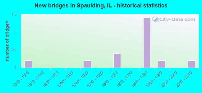
- New bridges - historical statistics
- 11900-1909
- 11940-1949
- 21960-1969
- 71980-1989
- 11990-1999
- 12010-2019


- Bridge Condition - Deck
- 9.1%Very good
- 63.6%Good
- 18.2%Satisfactory
- 9.1%Poor

- Bridge Condition - Superstructure
- 9.1%Very good
- 63.6%Good
- 18.2%Satisfactory
- 9.1%Poor

- Bridge Condition - Substructure
- 18.2%Very good
- 36.4%Good
- 27.3%Satisfactory
- 18.2%Fair

- Bridge Condition - Channel
- 16.7%Very good
- 33.3%Good
- 25.0%Satisfactory
- 16.7%Fair
- 8.3%Poor
Find on map >> Show street view
Structure Number: 840205, Location: SW EDGE SPAULDING (Lat: 39.859169, Lng: -89.555244), Route carried "on" structure: State highway 54, Year Built: 1997, Status: Open, Structure Length: 25.99m (85.27ft), Average Daily Traffic: 6,400 (year 2021), Truck Traffic: 5%, Average Future Daily Traffic: 7,504 (year 2032), Design Load: HS 20, Features Intersected: SANGAMON RIVER
Minimum Vertical Clearance: 5.59m (18.34ft), Kilometerpoint: 5.037, Lanes on structure: 2, Base Highway Network: Yes, Owner: State Highway Agency, Approaching Roadway Width: 14.2m (46.6ft), Material/Design: Steel continuous, Design/Construction: Stringer/Multi-beam, Number Of Spans In Main Unit: 5, Length of Maximum Span: 56.4m (185.0ft), Curb-To-Curb Width: 12.0m (39.4ft), Out-to-Out Width: 13.0m (42.7ft)
Condition: Deck: Good, Superstructure: Good, Substructure: Very good, Channel: Very good, Operating Rating: 70.0 metric tons, Method Used To Determine Operating Rating: Load Factor (LF) rating reported by rating factor (RF) method using MS18 loading, Inventory Rating: 42.1 metric tons, Method Used To Determine Inventory Rating: Load Factor (LF) rating reported by rating factor (RF) method using MS18 loading, Structural Evaluation: Better than present minimum criteria, Deck Geometry: Somewhat better than minimum adequacy, Waterway Adequacy: Superior to present desirable criteria, Approach Roadway Alignment: Equal to present desirable criteria, Designated Inspection Frequency: Every 24 months, Inspection Date: October 2021, Deck Structure Type: Concrete Cast-file-Place, Wearing Surface/Protective System: Deck Protection: Epoxy Coated Reinforcing
Find on map >> Show street view
Structure Number: 842002, Location: 1.6M E BARCLAY (Lat: 39.887231, Lng: -89.492561), Route carried "on" structure: State highway 54, Year Built: 1941, Status: Temporarily open, Structure Length: 1.20m (3.94ft), Average Daily Traffic: 2,350 (year 2021), Truck Traffic: 9%, Average Future Daily Traffic: 1,822 (year 2032), Design Load: H 20, Features Intersected: WOLF CREEK
Minimum Vertical Clearance: 30+ m (98+ ft), Kilometerpoint: 11.265, Lanes on structure: 2, Base Highway Network: Yes, Owner: State Highway Agency, Approaching Roadway Width: 12.8m (42.0ft), Material/Design: Concrete continuous, Design/Construction: Culvert, Number Of Spans In Main Unit: 3, Length of Maximum Span: 3.7m (12.1ft)
Condition: Channel: Satisfactory, Culverts: Poor, Operating Rating: 69.0 metric tons, Method Used To Determine Operating Rating: Load Factor (LF) rating reported by rating factor (RF) method using MS18 loading, Inventory Rating: 41.1 metric tons, Method Used To Determine Inventory Rating: Load Factor (LF) rating reported by rating factor (RF) method using MS18 loading, Structural Evaluation: Meets minimum limits, Waterway Adequacy: Equal to present minimum criteria, Approach Roadway Alignment: Equal to present desirable criteria, Designated Inspection Frequency: Every 12 months, Inspection Date: October 2021
Find on map >> Show street view
Structure Number: 84307, Location: 2.5 S WILLIAMSVILLE (Lat: 39.910839, Lng: -89.519486), Route carried "on" structure: County highway , Year Built: 1969, Status: Open, Structure Length: 2.93m (9.61ft), Average Daily Traffic: 150 (year 2017), Average Future Daily Traffic: 80 (year 2032), Design Load: HS 15, Features Intersected: WOLF CREEK, Facility Carried by Structure: TR 33 (7.5N)
Minimum Vertical Clearance: 30+ m (98+ ft), Kilometerpoint: 10.766, Lanes on structure: 2, Owner: Town or Township Highway Agency, Approaching Roadway Width: 4.9m (16.1ft), Material/Design: Concrete continuous, Design/Construction: Slab, Number Of Spans In Main Unit: 3, Length of Maximum Span: 11.0m (36.1ft), Curb-To-Curb Width: 7.3m (24.0ft), Out-to-Out Width: 7.9m (25.9ft)
Condition: Deck: Good, Superstructure: Good, Substructure: Fair, Channel: Fair, Operating Rating: 48.6 metric tons, Method Used To Determine Operating Rating: Load Factor (LF) rating reported by rating factor (RF) method using MS18 loading, Inventory Rating: 29.2 metric tons, Method Used To Determine Inventory Rating: Load Factor (LF) rating reported by rating factor (RF) method using MS18 loading, Structural Evaluation: Somewhat better than minimum adequacy, Deck Geometry: Somewhat better than minimum adequacy, Waterway Adequacy: Equal to present desirable criteria, Approach Roadway Alignment: Equal to present desirable criteria, Designated Inspection Frequency: Every 24 months, Inspection Date: March 2021, Deck Structure Type: Concrete Cast-file-Place
Find on map >> Show street view
Structure Number: 843171, Location: 4.5 S WILLIAMSVILLE (Lat: 39.881547, Lng: -89.555086), Route carried "on" structure: County highway , Year Built: 1962, Status: Open, Structure Length: 2.29m (7.51ft), Average Daily Traffic: 75 (year 2017), Average Future Daily Traffic: 80 (year 2032), Design Load: HS 15, Features Intersected: LITTLE WOLF CREEK, Facility Carried by Structure: TR 384
Minimum Vertical Clearance: 30+ m (98+ ft), Kilometerpoint: 3.895, Lanes on structure: 2, Owner: Town or Township Highway Agency, Approaching Roadway Width: 5.5m (18.0ft), Skew: 2 degrees, Material/Design: Concrete continuous, Design/Construction: Slab, Number Of Spans In Main Unit: 3, Length of Maximum Span: 8.5m (27.9ft), Curb-To-Curb Width: 7.3m (24.0ft), Out-to-Out Width: 8.0m (26.2ft)
Condition: Deck: Satisfactory, Superstructure: Satisfactory, Substructure: Fair, Channel: Poor, Operating Rating: 32.4 metric tons, Method Used To Determine Operating Rating: Load Factor (LF) rating reported by rating factor (RF) method using MS18 loading, Inventory Rating: 19.4 metric tons, Method Used To Determine Inventory Rating: Load Factor (LF) rating reported by rating factor (RF) method using MS18 loading, Structural Evaluation: Somewhat better than minimum adequacy, Deck Geometry: Equal to present minimum criteria, Waterway Adequacy: Better than present minimum criteria, Approach Roadway Alignment: Better than present minimum criteria, Designated Inspection Frequency: Every 24 months, Inspection Date: March 2021, Deck Structure Type: Concrete Cast-file-Place
Find on map >> Show street view
Structure Number: 843424, Location: 0.5 N OF SPAULDING (Lat: 39.874589, Lng: -89.539853), Route carried "on" structure: Other road , Year Built: 1985, Status: Open, Structure Length: 3.11m (10.20ft), Average Daily Traffic: 1,850 (year 2012), Truck Traffic: 4%, Average Future Daily Traffic: 2,090 (year 2032), Design Load: HS 20, Features Intersected: WOLF CREEK, Facility Carried by Structure: FAS 631-CTY HWY 31
Minimum Vertical Clearance: 30+ m (98+ ft), Kilometerpoint: 0.772, Lanes on structure: 2, Owner: County Highway Agency, Approaching Roadway Width: 7.3m (24.0ft), Material/Design: Concrete, Design/Construction: Channel Beam, Number Of Spans In Main Unit: 3, Length of Maximum Span: 10.4m (34.1ft), Curb-To-Curb Width: 11.6m (38.1ft), Out-to-Out Width: 12.6m (41.3ft)
Condition: Deck: Poor, Superstructure: Poor, Substructure: Satisfactory, Channel: Good, Operating Rating: 75.2 metric tons, Method Used To Determine Operating Rating: Load Factor (LF) rating reported by rating factor (RF) method using MS18 loading, Inventory Rating: 45.0 metric tons, Method Used To Determine Inventory Rating: Load Factor (LF) rating reported by rating factor (RF) method using MS18 loading, Structural Evaluation: Meets minimum limits, Deck Geometry: Equal to present minimum criteria, Waterway Adequacy: Equal to present desirable criteria, Approach Roadway Alignment: Better than present minimum criteria, Designated Inspection Frequency: Every 24 months, Inspection Date: March 2020, Deck Structure Type: Concrete Cast-file-Place, Wearing Surface/Protective System: Wearing Surface: Bituminous, Membrane: Built-up, Deck Protection: Internally Sealed
Find on map >> Show street view
Structure Number: 843428, Location: 2.0 NE OF SPAULDING (Lat: 39.896358, Lng: -89.517056), Route carried "on" structure: County highway , Year Built: 1984, Status: Open, Structure Length: 4.62m (15.16ft), Average Daily Traffic: 650 (year 2017), Truck Traffic: 6%, Average Future Daily Traffic: 697 (year 2032), Design Load: HS 20, Features Intersected: WOLF CREEK, Facility Carried by Structure: FAS 634 CH 01
Minimum Vertical Clearance: 30+ m (98+ ft), Kilometerpoint: 5.182, Lanes on structure: 2, Owner: County Highway Agency, Approaching Roadway Width: 6.7m (22.0ft), Skew: 3 degrees, Material/Design: Prestressed concrete, Design/Construction: Box Beam or Girders - Multiple, Number Of Spans In Main Unit: 3, Length of Maximum Span: 16.1m (52.8ft), Curb-To-Curb Width: 11.0m (36.1ft), Out-to-Out Width: 11.0m (36.1ft)
Condition: Deck: Satisfactory, Superstructure: Satisfactory, Substructure: Satisfactory, Channel: Satisfactory, Operating Rating: 73.2 metric tons, Method Used To Determine Operating Rating: Load Factor (LF) rating reported by rating factor (RF) method using MS18 loading, Inventory Rating: 32.1 metric tons, Method Used To Determine Inventory Rating: Load Factor (LF) rating reported by rating factor (RF) method using MS18 loading, Structural Evaluation: Equal to present minimum criteria, Deck Geometry: Better than present minimum criteria, Waterway Adequacy: Better than present minimum criteria, Approach Roadway Alignment: Better than present minimum criteria, Designated Inspection Frequency: Every 24 months, Inspection Date: March 2021, Deck Structure Type: Concrete Precast Panels, Wearing Surface/Protective System: Wearing Surface: Bituminous, Membrane: Built-up, Deck Protection: Internally Sealed
Find on map >> Show street view
Structure Number: 84356, Location: 1.0 E OF SPAULDING (Lat: 39.867411, Lng: -89.512314), Route carried "on" structure: County highway , Year Built: 1981, Status: Open, Structure Length: 2.44m (8.01ft), Average Daily Traffic: 125 (year 2017), Truck Traffic: 4%, Average Future Daily Traffic: 134 (year 2032), Design Load: HS 20, Features Intersected: TRIB TO WOLF CREEK, Facility Carried by Structure: TR103 4.5NBP105
Minimum Vertical Clearance: 30+ m (98+ ft), Kilometerpoint: 1.529, Lanes on structure: 2, Owner: Town or Township Highway Agency, Approaching Roadway Width: 4.9m (16.1ft), Material/Design: Prestressed concrete, Design/Construction: Box Beam or Girders - Multiple, Number Of Spans In Main Unit: 3, Number Of Approach Spans: 3, Length of Maximum Span: 8.0m (26.2ft), Curb-To-Curb Width: 8.2m (26.9ft), Out-to-Out Width: 8.3m (27.2ft)
Condition: Deck: Good, Superstructure: Good, Substructure: Good, Channel: Good, Operating Rating: 44.4 metric tons, Method Used To Determine Operating Rating: Assigned rating based on Load Factor Design (LFD) reported by rating factor (RF) using MS18 loading, Inventory Rating: 32.4 metric tons, Method Used To Determine Inventory Rating: Assigned rating based on Load Factor Design (LFD) reported by rating factor (RF) using MS18 loading, Structural Evaluation: Better than present minimum criteria, Deck Geometry: Somewhat better than minimum adequacy, Waterway Adequacy: Equal to present desirable criteria, Approach Roadway Alignment: Better than present minimum criteria, Designated Inspection Frequency: Every 48 months, Inspection Date: March 2019, Deck Structure Type: Concrete Precast Panels, Wearing Surface/Protective System: Wearing Surface: Bituminous
Find on map >> Show street view
Structure Number: 84357, Location: 1.0 E SPAULDING (Lat: 39.866036, Lng: -89.511400), Route carried "on" structure: County highway , Year Built: 1982, Status: Open, Structure Length: 2.10m (6.89ft), Average Daily Traffic: 125 (year 2017), Average Future Daily Traffic: 134 (year 2032), Design Load: HS 20, Features Intersected: TRIB TO WOLF CREEK, Facility Carried by Structure: CLEAR LAKE TR438
Minimum Vertical Clearance: 30+ m (98+ ft), Kilometerpoint: 1.239, Lanes on structure: 2, Owner: Town or Township Highway Agency, Approaching Roadway Width: 5.5m (18.0ft), Skew: 3 degrees, Material/Design: Prestressed concrete, Design/Construction: Box Beam or Girders - Multiple, Number Of Spans In Main Unit: 1, Length of Maximum Span: 20.2m (66.3ft), Curb-To-Curb Width: 8.2m (26.9ft), Out-to-Out Width: 8.2m (26.9ft)
Condition: Deck: Good, Superstructure: Good, Substructure: Satisfactory, Channel: Good, Operating Rating: 44.4 metric tons, Method Used To Determine Operating Rating: Assigned rating based on Load Factor Design (LFD) reported by rating factor (RF) using MS18 loading, Inventory Rating: 32.4 metric tons, Method Used To Determine Inventory Rating: Assigned rating based on Load Factor Design (LFD) reported by rating factor (RF) using MS18 loading, Structural Evaluation: Equal to present minimum criteria, Deck Geometry: Somewhat better than minimum adequacy, Waterway Adequacy: Equal to present desirable criteria, Approach Roadway Alignment: Equal to present desirable criteria, Designated Inspection Frequency: Every 24 months, Inspection Date: March 2021, Deck Structure Type: Concrete Precast Panels, Wearing Surface/Protective System: Wearing Surface: Bituminous
Find on map >> Show street view
Structure Number: 843572, Location: 0.29 mi E FAS 633 (Lat: 39.881656, Lng: -89.534261), Route carried "on" structure: County highway , Year Built: 2019, Status: Open, Structure Length: 2.61m (8.56ft), Average Daily Traffic: 75 (year 2017), Average Future Daily Traffic: 80 (year 2032), Design Load: HS 25 or greater, Features Intersected: Wolf Creek, Facility Carried by Structure: TR 384
Minimum Vertical Clearance: 30+ m (98+ ft), Kilometerpoint: 5.697, Lanes on structure: 2, Owner: Town or Township Highway Agency, Approaching Roadway Width: 6.1m (20.0ft), Skew: 1 degrees, Material/Design: Prestressed concrete, Design/Construction: Box Beam or Girders - Multiple, Number Of Spans In Main Unit: 1, Length of Maximum Span: 0.0m, Curb-To-Curb Width: 8.5m (27.9ft), Out-to-Out Width: 8.5m (27.9ft)
Condition: Deck: Very good, Superstructure: Very good, Substructure: Very good, Channel: Very good, Operating Rating: 56.4 metric tons, Method Used To Determine Operating Rating: Load and Resistance Factor Rating (LRFR) rating reported by rating factor(RF) method using HL-93 loadings, Inventory Rating: 43.7 metric tons, Method Used To Determine Inventory Rating: Load and Resistance Factor Rating (LRFR) rating reported by rating factor(RF) method using HL-93 loadings, Structural Evaluation: Equal to present desirable criteria, Deck Geometry: Better than present minimum criteria, Waterway Adequacy: Equal to present desirable criteria, Approach Roadway Alignment: Equal to present desirable criteria, Designated Inspection Frequency: Every 24 months, Inspection Date: March 2020, Deck Structure Type: Concrete Precast Panels, Wearing Surface/Protective System: Wearing Surface: Bituminous, Membrane: Built-up, Deck Protection: Epoxy Coated Reinforcing
Find on map >> Show street view
Structure Number: 843591, Location: 1.5 NE SPAULDING (Lat: 39.884486, Lng: -89.511608), Route carried "on" structure: County highway , Year Built: 1980, Status: Open, Structure Length: 3.32m (10.89ft), Average Daily Traffic: 75 (year 2017), Average Future Daily Traffic: 80 (year 2032), Design Load: HS 20, Features Intersected: WOLF CREEK, Facility Carried by Structure: WILLIAMS TR 438
Minimum Vertical Clearance: 30+ m (98+ ft), Kilometerpoint: 0.129, Lanes on structure: 2, Owner: Town or Township Highway Agency, Approaching Roadway Width: 4.3m (14.1ft), Material/Design: Prestressed concrete, Design/Construction: Box Beam or Girders - Multiple, Number Of Spans In Main Unit: 3, Length of Maximum Span: 11.0m (36.1ft), Curb-To-Curb Width: 8.2m (26.9ft), Out-to-Out Width: 8.2m (26.9ft)
Condition: Deck: Good, Superstructure: Good, Substructure: Good, Channel: Fair, Operating Rating: 44.4 metric tons, Method Used To Determine Operating Rating: Assigned rating based on Load Factor Design (LFD) reported by rating factor (RF) using MS18 loading, Inventory Rating: 32.4 metric tons, Method Used To Determine Inventory Rating: Assigned rating based on Load Factor Design (LFD) reported by rating factor (RF) using MS18 loading, Structural Evaluation: Better than present minimum criteria, Deck Geometry: Equal to present minimum criteria, Waterway Adequacy: Better than present minimum criteria, Approach Roadway Alignment: Better than present minimum criteria, Designated Inspection Frequency: Every 48 months, Inspection Date: March 2019, Deck Structure Type: Concrete Precast Panels, Wearing Surface/Protective System: Wearing Surface: Bituminous
Find on map >> Show street view
Structure Number: 843594, Location: 1.0 E OF SPAULDING (Lat: 39.879372, Lng: -89.516306), Route carried "on" structure: County highway , Year Built: 1986, Status: Open, Structure Length: 4.01m (13.16ft), Average Daily Traffic: 425 (year 2017), Truck Traffic: 10%, Average Future Daily Traffic: 429 (year 2032), Design Load: HS 20, Features Intersected: WOLF CREEK, Facility Carried by Structure: TR 442
Minimum Vertical Clearance: 30+ m (98+ ft), Kilometerpoint: 1.867, Lanes on structure: 2, Owner: Town or Township Highway Agency, Approaching Roadway Width: 7.3m (24.0ft), Material/Design: Prestressed concrete, Design/Construction: Box Beam or Girders - Multiple, Number Of Spans In Main Unit: 3, Length of Maximum Span: 15.2m (49.9ft), Curb-To-Curb Width: 8.5m (27.9ft), Out-to-Out Width: 8.5m (27.9ft)
Condition: Deck: Good, Superstructure: Good, Substructure: Good, Channel: Good, Operating Rating: 44.4 metric tons, Method Used To Determine Operating Rating: Assigned rating based on Load Factor Design (LFD) reported by rating factor (RF) using MS18 loading, Inventory Rating: 32.4 metric tons, Method Used To Determine Inventory Rating: Assigned rating based on Load Factor Design (LFD) reported by rating factor (RF) using MS18 loading, Structural Evaluation: Better than present minimum criteria, Deck Geometry: Somewhat better than minimum adequacy, Waterway Adequacy: Equal to present desirable criteria, Approach Roadway Alignment: Equal to present desirable criteria, Designated Inspection Frequency: Every 48 months, Inspection Date: March 2019, Deck Structure Type: Concrete Precast Panels, Wearing Surface/Protective System: Wearing Surface: Bituminous
Find on map >> Show street view
Structure Number: 843625, Location: 3.5 S WILLIAMSVILLE (Lat: 39.896064, Lng: -89.550447), Route carried "on" structure: County highway , Year Built: 1984, Status: Open, Structure Length: 2.05m (6.73ft), Average Daily Traffic: 1,550 (year 2017), Truck Traffic: 5%, Average Future Daily Traffic: 1,983 (year 2032), Design Load: HS 20, Features Intersected: LITTLE WOLF CREEK, Facility Carried by Structure: FAS 634 CH 01
Minimum Vertical Clearance: 30+ m (98+ ft), Kilometerpoint: 2.350, Lanes on structure: 2, Owner: County Highway Agency, Approaching Roadway Width: 7.3m (24.0ft), Skew: 1 degrees, Material/Design: Prestressed concrete, Design/Construction: Box Beam or Girders - Multiple, Number Of Spans In Main Unit: 1, Length of Maximum Span: 19.8m (65.0ft), Curb-To-Curb Width: 11.0m (36.1ft), Out-to-Out Width: 11.0m (36.1ft)
Condition: Deck: Good, Superstructure: Good, Substructure: Good, Channel: Satisfactory, Operating Rating: 77.4 metric tons, Method Used To Determine Operating Rating: Load Factor (LF) rating reported by rating factor (RF) method using MS18 loading, Inventory Rating: 33.7 metric tons, Method Used To Determine Inventory Rating: Load Factor (LF) rating reported by rating factor (RF) method using MS18 loading, Structural Evaluation: Better than present minimum criteria, Deck Geometry: Equal to present minimum criteria, Waterway Adequacy: Equal to present minimum criteria, Approach Roadway Alignment: Equal to present desirable criteria, Designated Inspection Frequency: Every 48 months, Inspection Date: March 2019, Deck Structure Type: Concrete Precast Panels, Wearing Surface/Protective System: Wearing Surface: Bituminous, Membrane: Built-up, Deck Protection: Internally Sealed
Find on map >> Show street view
Structure Number: 84993, Location: 1 MI E BARCLAY (Lat: 39.887553, Lng: -89.492650), Route carried "under" structure: County highway , Year Built: 1900, Structure Length: 0. m, Average Daily Traffic: 150 (year 2017), Truck Traffic: 1%, Features Intersected: TR 464, Facility Carried by Structure: IC&G RR
Minimum Vertical Clearance: 3.02m (9.91ft), Kilometerpoint: 1.014, Lanes under structure: 2, Material/Design: Concrete, Design/Construction: Arch - Deck, Length of Maximum Span: 6.7m (22.0ft)