Bridge Statistics for Speedway, Indiana (IN)
Condition, Traffic, Stress, Structural Evaluation, Project Costs
- National Bridge Inventory (NBI) Statistics
- 12Number of bridges
- 151ft / 45.8mTotal length
- $2,208,000Total costs
- 191,638Total average daily traffic
- 9,474Total average daily truck traffic
- 284,751Total future (year 2034) average daily traffic
- National Bridge Inventory (NBI) Registered Bridges for Speedway
- No street view available for this location
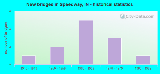
- New bridges - historical statistics
- 11940-1949
- 21950-1959
- 51960-1969
- 31970-1979
- 11980-1989
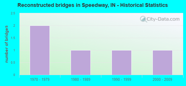
- Reconstructed bridges - Historical Statistics
- 21970-1979
- 11980-1989
- 11990-1999
- 12000-2009
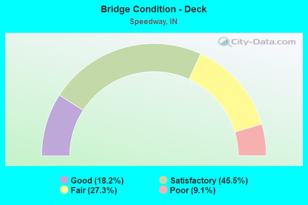
- Bridge Condition - Deck
- 18.2%Good
- 45.5%Satisfactory
- 27.3%Fair
- 9.1%Poor
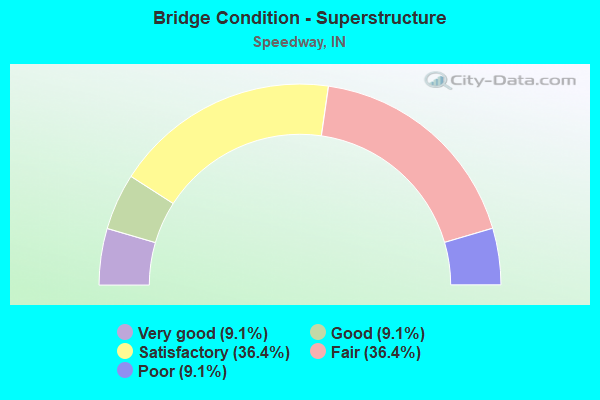
- Bridge Condition - Superstructure
- 9.1%Very good
- 9.1%Good
- 36.4%Satisfactory
- 36.4%Fair
- 9.1%Poor
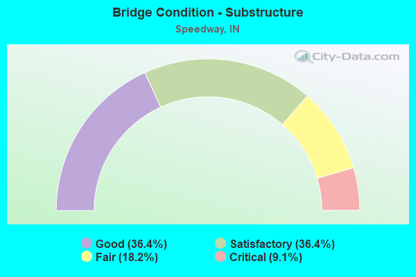
- Bridge Condition - Substructure
- 36.4%Good
- 36.4%Satisfactory
- 18.2%Fair
- 9.1%Critical
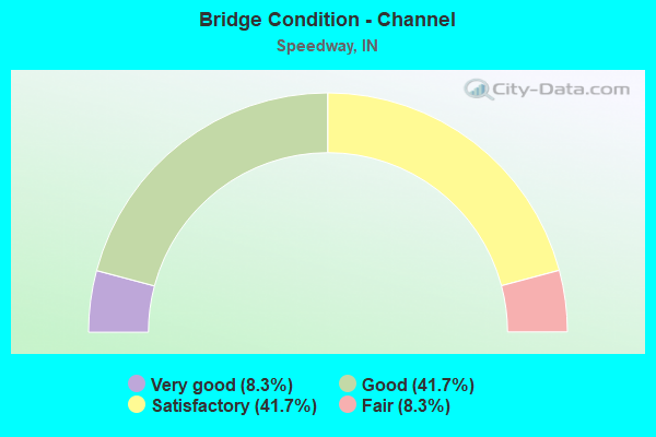
- Bridge Condition - Channel
- 8.3%Very good
- 41.7%Good
- 41.7%Satisfactory
- 8.3%Fair
Find on map >> Show street view
Structure Number: 490011, Location: 00.50 S OF 34TH ST (Lat: 39.809131, Lng: -86.255822), Route carried "on" structure: City street 195, Year Built: 1964, Year Reconstructed: 2013, Status: Open, Structure Length: 4.70m (15.42ft), Average Daily Traffic: 13,743 (year 2014), Truck Traffic: 5%, Average Future Daily Traffic: 20,422 (year 2034), Design Load: HS 20, Features Intersected: DRY RUN, Facility Carried by Structure: MOLLER RD
Minimum Vertical Clearance: 30+ m (98+ ft), Kilometerpoint: 0.000, Lanes on structure: 2, Owner: City or Municipal Highway Agency, Approaching Roadway Width: 9.8m (32.2ft), Skew: 4 degrees, Material/Design: Prestressed concrete, Design/Construction: Box Beam or Girders - Single/Spread, Number Of Spans In Main Unit: 4, Length of Maximum Span: 11.5m (37.7ft), Curb or Sidewalk Widths: Left: 1.5m (4.9ft), Right: 0.0m, Curb-To-Curb Width: 10.1m (33.1ft), Out-to-Out Width: 12.3m (40.4ft)
Condition: Deck: Good, Superstructure: Very good, Substructure: Satisfactory, Channel: Good, Operating Rating: 85.3 metric tons, Method Used To Determine Operating Rating: Load and Resistance Factor (LRFR), Inventory Rating: 70.7 metric tons, Method Used To Determine Inventory Rating: Load and Resistance Factor (LRFR), Structural Evaluation: Equal to present minimum criteria, Deck Geometry: Meets minimum limits, Waterway Adequacy: Equal to present desirable criteria, Approach Roadway Alignment: Equal to present desirable criteria, Designated Inspection Frequency: Every 48 months, Inspection Date: August 2018, Deck Structure Type: Concrete Cast-file-Place, Wearing Surface/Protective System: Wearing Surface: Monolithic Concrete, Deck Protection: Epoxy Coated Reinforcing
Find on map >> Show street view
Structure Number: 4900111, Location: 00.32 S OF 30TH ST (Lat: 39.804619, Lng: -86.239850), Route carried "on" structure: City street , Year Built: 1964, Year Reconstructed: 1979, Status: Posted for load, Structure Length: 2.53m (8.30ft), Average Daily Traffic: 23,217 (year 2019), Truck Traffic: 5%, Average Future Daily Traffic: 34,499 (year 2039), Design Load: HS 20, Features Intersected: DRY RUN DIVERSION, Facility Carried by Structure: GEORGETOWN RD
Minimum Vertical Clearance: 30+ m (98+ ft), Kilometerpoint: 0.000, Lanes on structure: 4, Owner: City or Municipal Highway Agency, Approaching Roadway Width: 15.5m (50.9ft), Material/Design: Prestressed concrete continuous, Design/Construction: Box Beam or Girders - Single/Spread, Number Of Spans In Main Unit: 3, Length of Maximum Span: 8.5m (27.9ft), Curb or Sidewalk Widths: Left: 0.0m, Right: 1.2m (3.9ft), Curb-To-Curb Width: 15.5m (50.9ft), Out-to-Out Width: 17.5m (57.4ft)
Condition: Deck: Satisfactory, Superstructure: Satisfactory, Substructure: Satisfactory, Channel: Satisfactory, Operating Rating: 40.7 metric tons, Method Used To Determine Operating Rating: Load and Resistance Factor (LRFR), Inventory Rating: 33.7 metric tons, Method Used To Determine Inventory Rating: Load and Resistance Factor (LRFR), Structural Evaluation: Equal to present minimum criteria, Deck Geometry: Meets minimum limits, Waterway Adequacy: Equal to present desirable criteria, Approach Roadway Alignment: Equal to present desirable criteria, Length Of Structure Improvement: 2.53m (8.30ft), Designated Inspection Frequency: Every 24 months, Inspection Date: August 2020, Bridge Improvement Cost: $240,000, Roadway Improvement Cost: $90,000, Total Project Cost: $413,000 ( Estimate for 2020), Deck Structure Type: Concrete Cast-file-Place, Wearing Surface/Protective System: Wearing Surface: Latex Concrete
Find on map >> Show street view
Structure Number: 490018, Location: 00.10 S OF 10TH ST (Lat: 39.777039, Lng: -86.308167), Route carried "on" structure: City street 103, Year Built: 1948, Status: Open, Structure Length: 1.29m (4.23ft), Average Daily Traffic: 10,222 (year 2019), Truck Traffic: 4%, Average Future Daily Traffic: 15,190 (year 2039), Features Intersected: WHITE LICK CREEK, Facility Carried by Structure: COUNTRY CLUB RD
Minimum Vertical Clearance: 30+ m (98+ ft), Kilometerpoint: 0.000, Lanes on structure: 2, Owner: City or Municipal Highway Agency, Approaching Roadway Width: 7.3m (24.0ft), Material/Design: Concrete, Design/Construction: Arch - Deck, Number Of Spans In Main Unit: 1, Length of Maximum Span: 10.4m (34.1ft), Curb-To-Curb Width: 7.3m (24.0ft), Out-to-Out Width: 8.2m (26.9ft)
Condition: Deck: Satisfactory, Superstructure: Satisfactory, Substructure: Fair, Channel: Fair, Operating Rating: 32.7 metric tons, Method Used To Determine Operating Rating: Field evaluation and documented engineering judgment, Inventory Rating: 32.7 metric tons, Method Used To Determine Inventory Rating: Field evaluation and documented engineering judgment, Structural Evaluation: Somewhat better than minimum adequacy, Deck Geometry: High priority of replacement, Waterway Adequacy: Somewhat better than minimum adequacy, Approach Roadway Alignment: Equal to present minimum criteria, Designated Inspection Frequency: Every 24 months, Inspection Date: August 2020, Deck Structure Type: Concrete Cast-file-Place, Wearing Surface/Protective System: Wearing Surface: Bituminous
Find on map >> Show street view
Structure Number: 4900185, Location: 00.30 E OF GEORGETOWN ROA (Lat: 39.787689, Lng: -86.228217), Route carried "on" structure: City street , Year Built: 1959, Status: Open, Structure Length: 2.25m (7.38ft), Average Daily Traffic: 25,774 (year 2019), Truck Traffic: 5%, Average Future Daily Traffic: 38,300 (year 2039), Design Load: H 20, Features Intersected: DRY RUN, Facility Carried by Structure: 16TH STREET
Minimum Vertical Clearance: 30+ m (98+ ft), Kilometerpoint: 0.000, Lanes on structure: 6, Owner: City or Municipal Highway Agency, Approaching Roadway Width: 21.9m (71.9ft), Skew: 4 degrees, Material/Design: Concrete continuous, Design/Construction: Slab, Number Of Spans In Main Unit: 3, Length of Maximum Span: 8.5m (27.9ft), Curb or Sidewalk Widths: Left: 1.5m (4.9ft), Right: 1.5m (4.9ft), Curb-To-Curb Width: 22.0m (72.2ft), Out-to-Out Width: 25.7m (84.3ft)
Condition: Deck: Fair, Superstructure: Fair, Substructure: Fair, Channel: Good, Operating Rating: 50.2 metric tons, Method Used To Determine Operating Rating: Load and Resistance Factor (LRFR), Inventory Rating: 41.6 metric tons, Method Used To Determine Inventory Rating: Load and Resistance Factor (LRFR), Structural Evaluation: Somewhat better than minimum adequacy, Deck Geometry: High priority of corrective action, Waterway Adequacy: Equal to present desirable criteria, Approach Roadway Alignment: Equal to present desirable criteria, Designated Inspection Frequency: Every 24 months, Inspection Date: August 2020, Deck Structure Type: Concrete Cast-file-Place, Wearing Surface/Protective System: Wearing Surface: Bituminous
Find on map >> Show street view
Structure Number: 4900187, Location: 01.05 E OF LYNHURST DRIVE (Lat: 39.780319, Lng: -86.230783), Route carried "on" structure: City street 110, Year Built: 1988, Status: Open, Structure Length: 4.40m (14.44ft), Average Daily Traffic: 28,240 (year 2019), Truck Traffic: 5%, Average Future Daily Traffic: 41,960 (year 2039), Design Load: HS 20, Features Intersected: LITTLE EAGLE CREEK, Facility Carried by Structure: 10TH STREET
Minimum Vertical Clearance: 30+ m (98+ ft), Kilometerpoint: 0.000, Lanes on structure: 5, Owner: City or Municipal Highway Agency, Approaching Roadway Width: 19.2m (63.0ft), Material/Design: Prestressed concrete continuous, Design/Construction: Box Beam or Girders - Single/Spread, Number Of Spans In Main Unit: 3, Length of Maximum Span: 14.3m (46.9ft), Curb or Sidewalk Widths: Left: 1.8m (5.9ft), Right: 1.8m (5.9ft), Curb-To-Curb Width: 19.1m (62.7ft), Out-to-Out Width: 23.6m (77.4ft)
Condition: Deck: Satisfactory, Superstructure: Fair, Substructure: Good, Channel: Good, Operating Rating: 64.7 metric tons, Method Used To Determine Operating Rating: Load and Resistance Factor (LRFR), Inventory Rating: 53.6 metric tons, Method Used To Determine Inventory Rating: Load and Resistance Factor (LRFR), Structural Evaluation: Somewhat better than minimum adequacy, Deck Geometry: Meets minimum limits, Waterway Adequacy: Equal to present desirable criteria, Approach Roadway Alignment: Equal to present desirable criteria, Designated Inspection Frequency: Every 24 months, Inspection Date: August 2020, Deck Structure Type: Concrete Cast-file-Place, Wearing Surface/Protective System: Wearing Surface: Monolithic Concrete, Deck Protection: Epoxy Coated Reinforcing
Find on map >> Show street view
Structure Number: 4900188, Location: 00.60 E OF GEORGETOWN ROA (Lat: 39.787411, Lng: -86.233919), Route carried "on" structure: City street , Year Built: 1958, Year Reconstructed: 1979, Status: Open, Structure Length: 4.08m (13.39ft), Average Daily Traffic: 25,774 (year 2019), Truck Traffic: 5%, Average Future Daily Traffic: 38,300 (year 2039), Design Load: H 20, Features Intersected: LITTLE EAGLE CREEK, Facility Carried by Structure: 16TH STREET
Minimum Vertical Clearance: 30+ m (98+ ft), Kilometerpoint: 0.000, Lanes on structure: 6, Owner: City or Municipal Highway Agency, Approaching Roadway Width: 20.7m (67.9ft), Skew: 1 degrees, Material/Design: Steel continuous, Design/Construction: Stringer/Multi-beam, Number Of Spans In Main Unit: 3, Length of Maximum Span: 14.6m (47.9ft), Curb or Sidewalk Widths: Left: 1.5m (4.9ft), Right: 1.5m (4.9ft), Curb-To-Curb Width: 20.8m (68.2ft), Out-to-Out Width: 24.5m (80.4ft)
Condition: Deck: Fair, Superstructure: Satisfactory, Substructure: Critical, Channel: Satisfactory, Operating Rating: 40.3 metric tons, Method Used To Determine Operating Rating: Load and Resistance Factor (LRFR), Inventory Rating: 37.2 metric tons, Method Used To Determine Inventory Rating: Load and Resistance Factor (LRFR), Structural Evaluation: High priority of replacement, Deck Geometry: High priority of replacement, Waterway Adequacy: Equal to present desirable criteria, Approach Roadway Alignment: Equal to present desirable criteria, Length Of Structure Improvement: 4.08m (13.39ft), Designated Inspection Frequency: Every 12 months, Inspection Date: August 2021, Bridge Improvement Cost: $400,000, Roadway Improvement Cost: $184,000, Total Project Cost: $707,000 ( Estimate for 2020), Deck Structure Type: Concrete Cast-file-Place, Wearing Surface/Protective System: Wearing Surface: Latex Concrete
Find on map >> Show street view
Structure Number: 490019, Location: 00.45 W OF LYNHURST DRIVE (Lat: 39.779761, Lng: -86.258903), Route carried "on" structure: City street 110, Year Built: 1970, Year Reconstructed: 1999, Status: Open, Structure Length: 13.75m (45.11ft), Average Daily Traffic: 38,589 (year 2019), Truck Traffic: 5%, Average Future Daily Traffic: 57,340 (year 2039), Features Intersected: BIG EAGLE CREEK, Facility Carried by Structure: 10TH STREET
Minimum Vertical Clearance: 30+ m (98+ ft), Kilometerpoint: 0.000, Lanes on structure: 4, Owner: City or Municipal Highway Agency, Approaching Roadway Width: 21.6m (70.9ft), Skew: 4 degrees, Material/Design: Prestressed concrete continuous, Design/Construction: Stringer/Multi-beam, Number Of Spans In Main Unit: 5, Length of Maximum Span: 30.5m (100.1ft), Curb or Sidewalk Widths: Left: 1.2m (3.9ft), Right: 1.2m (3.9ft), Curb-To-Curb Width: 17.2m (56.4ft), Out-to-Out Width: 20.3m (66.6ft)
Condition: Deck: Satisfactory, Superstructure: Fair, Substructure: Satisfactory, Channel: Satisfactory, Operating Rating: 32.7 metric tons, Method Used To Determine Operating Rating: Field evaluation and documented engineering judgment, Inventory Rating: 32.7 metric tons, Method Used To Determine Inventory Rating: Field evaluation and documented engineering judgment, Structural Evaluation: Somewhat better than minimum adequacy, Deck Geometry: Somewhat better than minimum adequacy, Waterway Adequacy: Equal to present desirable criteria, Approach Roadway Alignment: Equal to present desirable criteria, Designated Inspection Frequency: Every 24 months, Inspection Date: August 2020, Deck Structure Type: Concrete Cast-file-Place, Wearing Surface/Protective System: Wearing Surface: Monolithic Concrete
Find on map >> Show street view
Structure Number: 4900193, Location: 00.40 N OF 16TH ST (Lat: 39.794711, Lng: -86.240447), Route carried "on" structure: City street 4279, Year Built: 1970, Status: Open, Structure Length: 1.12m (3.67ft), Average Daily Traffic: 500 (year 2020), Truck Traffic: 5%, Average Future Daily Traffic: 740 (year 2040), Features Intersected: DRY RUN, Facility Carried by Structure: GEORGETOWN RD
Minimum Vertical Clearance: 30+ m (98+ ft), Kilometerpoint: 0.000, Lanes on structure: 4, Owner: City or Municipal Highway Agency, Approaching Roadway Width: 15.2m (49.9ft), Skew: 4 degrees, Material/Design: Prestressed concrete, Design/Construction: Box Beam or Girders - Multiple, Number Of Spans In Main Unit: 1, Length of Maximum Span: 10.2m (33.5ft), Curb or Sidewalk Widths: Left: 0.3m (1.0ft), Right: 1.7m (5.6ft), Curb-To-Curb Width: 15.2m (49.9ft), Out-to-Out Width: 17.2m (56.4ft)
Condition: Deck: Poor, Superstructure: Poor, Substructure: Good, Channel: Satisfactory, Operating Rating: 50.0 metric tons, Method Used To Determine Operating Rating: Load and Resistance Factor (LRFR), Inventory Rating: 37.1 metric tons, Method Used To Determine Inventory Rating: Load and Resistance Factor (LRFR), Structural Evaluation: Meets minimum limits, Deck Geometry: High priority of corrective action, Waterway Adequacy: Equal to present desirable criteria, Approach Roadway Alignment: Equal to present desirable criteria, Length Of Structure Improvement: 1.80m (5.91ft), Designated Inspection Frequency: Every 12 months, Inspection Date: August 2021, Bridge Improvement Cost: $277,000, Roadway Improvement Cost: $184,000, Total Project Cost: $582,000 ( Estimate for 2020), Deck Structure Type: Concrete Precast Panels, Wearing Surface/Protective System: Wearing Surface: Bituminous
Find on map >> Show street view
Structure Number: 4900194, Location: 00.60 N OF CRAWFORDSVILLE (Lat: 39.798100, Lng: -86.244439), Route carried "on" structure: City street , Year Built: 1967, Status: Open, Structure Length: 2.15m (7.05ft), Average Daily Traffic: 1,541 (year 2019), Truck Traffic: 5%, Average Future Daily Traffic: 2,290 (year 2039), Features Intersected: DRY RUN, Facility Carried by Structure: AUBURN ST
Minimum Vertical Clearance: 30+ m (98+ ft), Kilometerpoint: 0.000, Lanes on structure: 2, Owner: City or Municipal Highway Agency, Approaching Roadway Width: 9.1m (29.9ft), Skew: 2 degrees, Material/Design: Concrete continuous, Design/Construction: Slab, Number Of Spans In Main Unit: 3, Length of Maximum Span: 8.2m (26.9ft), Curb or Sidewalk Widths: Left: 0.8m (2.6ft), Right: 0.8m (2.6ft), Curb-To-Curb Width: 9.1m (29.9ft), Out-to-Out Width: 11.4m (37.4ft)
Condition: Deck: Satisfactory, Superstructure: Satisfactory, Substructure: Good, Channel: Good, Operating Rating: 32.7 metric tons, Method Used To Determine Operating Rating: Field evaluation and documented engineering judgment, Inventory Rating: 32.7 metric tons, Method Used To Determine Inventory Rating: Field evaluation and documented engineering judgment, Structural Evaluation: Equal to present minimum criteria, Deck Geometry: Somewhat better than minimum adequacy, Waterway Adequacy: Equal to present desirable criteria, Approach Roadway Alignment: Equal to present desirable criteria, Designated Inspection Frequency: Every 48 months, Inspection Date: August 2018, Deck Structure Type: Concrete Cast-file-Place, Wearing Surface/Protective System: Wearing Surface: Bituminous
Find on map >> Show street view
Structure Number: 4900195, Location: 00.70 N OF CRAWFORDSVILLE (Lat: 39.799681, Lng: -86.246597), Route carried "on" structure: City street , Year Built: 1960, Status: Open, Structure Length: 0.73m (2.40ft), Average Daily Traffic: 1,326 (year 2019), Truck Traffic: 5%, Average Future Daily Traffic: 1,970 (year 2039), Features Intersected: DRY RUN, Facility Carried by Structure: ALLISON AVE
Minimum Vertical Clearance: 30+ m (98+ ft), Kilometerpoint: 0.000, Lanes on structure: 2, Owner: City or Municipal Highway Agency, Approaching Roadway Width: 8.8m (28.9ft), Material/Design: Concrete, Design/Construction: Slab, Number Of Spans In Main Unit: 1, Length of Maximum Span: 6.1m (20.0ft), Curb or Sidewalk Widths: Left: 0.8m (2.6ft), Right: 0.8m (2.6ft), Curb-To-Curb Width: 8.8m (28.9ft), Out-to-Out Width: 11.1m (36.4ft)
Condition: Deck: Fair, Superstructure: Fair, Substructure: Satisfactory, Channel: Very good, Operating Rating: 32.7 metric tons, Method Used To Determine Operating Rating: Field evaluation and documented engineering judgment, Inventory Rating: 32.7 metric tons, Method Used To Determine Inventory Rating: Field evaluation and documented engineering judgment, Structural Evaluation: Somewhat better than minimum adequacy, Deck Geometry: Somewhat better than minimum adequacy, Waterway Adequacy: Equal to present desirable criteria, Approach Roadway Alignment: Equal to present desirable criteria, Designated Inspection Frequency: Every 24 months, Inspection Date: August 2020, Deck Structure Type: Concrete Cast-file-Place, Wearing Surface/Protective System: Wearing Surface: Bituminous
Find on map >> Show street view
Structure Number: 4900196, Location: 00.30 E I-465 (Lat: 39.794281, Lng: -86.268744), Route carried "on" structure: City street 148, Year Built: 1972, Year Reconstructed: 1986, Status: Open, Structure Length: 7.99m (26.21ft), Average Daily Traffic: 12,917 (year 2019), Truck Traffic: 5%, Average Future Daily Traffic: 19,190 (year 2039), Design Load: HS 20, Features Intersected: BIG EAGLE CREEK, Facility Carried by Structure: 21ST ST
Minimum Vertical Clearance: 30+ m (98+ ft), Kilometerpoint: 0.000, Lanes on structure: 2, Owner: City or Municipal Highway Agency, Approaching Roadway Width: 9.8m (32.2ft), Skew: 1 degrees, Material/Design: Steel continuous, Design/Construction: Stringer/Multi-beam, Number Of Spans In Main Unit: 3, Length of Maximum Span: 30.3m (99.4ft), Curb-To-Curb Width: 9.4m (30.8ft), Out-to-Out Width: 10.5m (34.4ft)
Condition: Deck: Good, Superstructure: Good, Substructure: Good, Channel: Good, Operating Rating: 68.2 metric tons, Method Used To Determine Operating Rating: Load Factor (LF), Inventory Rating: 40.9 metric tons, Method Used To Determine Inventory Rating: Load Factor (LF), Structural Evaluation: Better than present minimum criteria, Deck Geometry: Meets minimum limits, Waterway Adequacy: Equal to present desirable criteria, Approach Roadway Alignment: Equal to present desirable criteria, Designated Inspection Frequency: Every 24 months, Inspection Date: August 2020, Deck Structure Type: Concrete Cast-file-Place, Wearing Surface/Protective System: Wearing Surface: Latex Concrete
Find on map >> Show street view
Structure Number: 4900197, Location: 00.10 E OF LYNHURST DR (Lat: 39.801950, Lng: -86.249175), Route carried "on" structure: City street , Year Built: 1969, Status: Open, Structure Length: 0.76m (2.49ft), Average Daily Traffic: 9,795 (year 2019), Truck Traffic: 5%, Average Future Daily Traffic: 14,550 (year 2039), Features Intersected: DRY RUN, Facility Carried by Structure: 25TH ST
Minimum Vertical Clearance: 30+ m (98+ ft), Kilometerpoint: 0.000, Lanes on structure: 4, Owner: City or Municipal Highway Agency, Approaching Roadway Width: 14.3m (46.9ft), Skew: 2 degrees, Material/Design: Steel, Design/Construction: Culvert, Number Of Spans In Main Unit: 2, Length of Maximum Span: 3.6m (11.8ft), Curb or Sidewalk Widths: Left: 0.0m, Right: 1.2m (3.9ft), Curb-To-Curb Width: 14.3m (46.9ft), Out-to-Out Width: 14.3m (46.9ft)
Condition: Channel: Satisfactory, Culverts: Fair, Operating Rating: 67.4 metric tons, Method Used To Determine Operating Rating: Load and Resistance Factor (LRFR), Inventory Rating: 63.2 metric tons, Method Used To Determine Inventory Rating: Load and Resistance Factor (LRFR), Structural Evaluation: Somewhat better than minimum adequacy, Deck Geometry: High priority of replacement, Waterway Adequacy: Better than present minimum criteria, Approach Roadway Alignment: Equal to present desirable criteria, Length Of Structure Improvement: 1.40m (4.59ft), Designated Inspection Frequency: Every 24 months, Inspection Date: August 2020, Bridge Improvement Cost: $217,000, Roadway Improvement Cost: $184,000, Total Project Cost: $506,000 ( Estimate for 2020)