Bridge Statistics for Spencer, Tennessee (TN)
Condition, Traffic, Stress, Structural Evaluation, Project Costs
- National Bridge Inventory (NBI) Statistics
- 14Number of bridges
- 148ft / 45.3mTotal length
- $780,000Total costs
- 14,645Total average daily traffic
- 1,336Total average daily truck traffic
- National Bridge Inventory (NBI) Registered Bridges for Spencer
- No street view available for this location
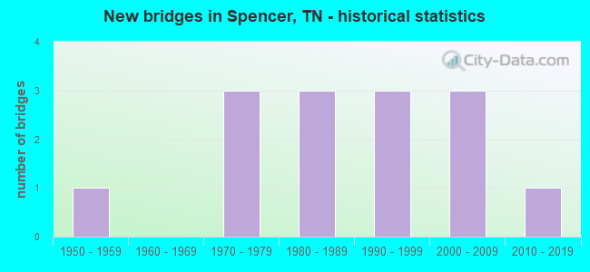
- New bridges - historical statistics
- 11950-1959
- 31970-1979
- 31980-1989
- 31990-1999
- 32000-2009
- 12010-2019


- Bridge Condition - Deck
- 83.3%Good
- 16.7%Satisfactory

- Bridge Condition - Superstructure
- 33.3%Very good
- 33.3%Good
- 33.3%Satisfactory

- Bridge Condition - Channel
- 8.3%Very good
- 50.0%Good
- 25.0%Satisfactory
- 8.3%Fair
- 8.3%Poor

- Bridge Condition - Culverts
- 85.7%Good
- 14.3%Fair
Find on map >> Show street view
Structure Number: 88021400003, Location: SOUTH OF CANEY FORK RIVES (Lat: 35.787783, Lng: -85.523200), Route carried "on" structure: County highway 2140, Year Built: 1950, Status: Open, Structure Length: 0.64m (2.10ft), Average Daily Traffic: 70 (year 2020), Truck Traffic: 3%, Average Future Daily Traffic: 144 (year 2041), Design Load: HS 20, Features Intersected: LITTLE DOUBLE CREEK
Minimum Vertical Clearance: 30+ m (98+ ft), Kilometerpoint: 9.431, Lanes on structure: 2, Owner: County Highway Agency, Approaching Roadway Width: 7.0m (23.0ft), Material/Design: Concrete continuous, Design/Construction: Culvert, Number Of Spans In Main Unit: 2, Length of Maximum Span: 3.0m (9.8ft)
Condition: Channel: Good, Culverts: Good, Operating Rating: 54.0 metric tons, Method Used To Determine Operating Rating: Field evaluation and documented engineering judgment, Inventory Rating: 32.4 metric tons, Method Used To Determine Inventory Rating: Field evaluation and documented engineering judgment, Structural Evaluation: Better than present minimum criteria, Waterway Adequacy: Equal to present minimum criteria, Approach Roadway Alignment: High priority of corrective action, Designated Inspection Frequency: Every 24 months, Inspection Date: October 2020
Find on map >> Show street view
Structure Number: 880A0230001, Location: 1 MI W OF SR 111 (Lat: 35.791367, Lng: -85.471733), Route carried "on" structure: County highway 23, Year Built: 1994, Status: Open, Structure Length: 0.67m (2.20ft), Average Daily Traffic: 50 (year 2022), Truck Traffic: 1%, Average Future Daily Traffic: 80 (year 2041), Design Load: HS 20, Features Intersected: COVE BRANCH
Minimum Vertical Clearance: 30+ m (98+ ft), Kilometerpoint: 5.626, Lanes on structure: 2, Owner: County Highway Agency, Approaching Roadway Width: 4.9m (16.1ft), Material/Design: Concrete continuous, Design/Construction: Culvert, Number Of Spans In Main Unit: 2, Length of Maximum Span: 3.0m (9.8ft), Curb-To-Curb Width: 6.8m (22.3ft), Out-to-Out Width: 8.5m (27.9ft)
Condition: Channel: Fair, Culverts: Good, Operating Rating: 87.3 metric tons, Method Used To Determine Operating Rating: Load Factor (LF), Inventory Rating: 32.4 metric tons, Method Used To Determine Inventory Rating: Load Factor (LF), Structural Evaluation: Better than present minimum criteria, Deck Geometry: Somewhat better than minimum adequacy, Waterway Adequacy: Better than present minimum criteria, Approach Roadway Alignment: Equal to present desirable criteria, Designated Inspection Frequency: Every 24 months, Inspection Date: October 2020, Deck Structure Type: Concrete Cast-file-Place, Wearing Surface/Protective System: Wearing Surface: Bituminous, Deck Protection: Epoxy Coated Reinforcing
Find on map >> Show street view
Structure Number: 880A1110001, Location: .2MI FROM SR 30 (Lat: 35.735067, Lng: -85.516817), Route carried "on" structure: County highway 111, Year Built: 1984, Status: Open, Structure Length: 1.01m (3.31ft), Average Daily Traffic: 30 (year 2022), Truck Traffic: 2%, Average Future Daily Traffic: 48 (year 2041), Design Load: HS 20, Features Intersected: LAUREL CREEK
Minimum Vertical Clearance: 30+ m (98+ ft), Kilometerpoint: 0.087, Lanes on structure: 2, Owner: County Highway Agency, Approaching Roadway Width: 6.1m (20.0ft), Material/Design: Concrete continuous, Design/Construction: Culvert, Number Of Spans In Main Unit: 2, Length of Maximum Span: 4.6m (15.1ft), Curb-To-Curb Width: 6.9m (22.6ft), Out-to-Out Width: 7.8m (25.6ft)
Condition: Channel: Poor, Culverts: Good, Operating Rating: 89.1 metric tons, Method Used To Determine Operating Rating: Load Factor (LF), Inventory Rating: 32.4 metric tons, Method Used To Determine Inventory Rating: Load Factor (LF), Structural Evaluation: Better than present minimum criteria, Deck Geometry: Somewhat better than minimum adequacy, Waterway Adequacy: Better than present minimum criteria, Approach Roadway Alignment: Equal to present minimum criteria, Designated Inspection Frequency: Every 24 months, Inspection Date: October 2020, Deck Structure Type: Concrete Cast-file-Place, Wearing Surface/Protective System: Wearing Surface: Monolithic Concrete
Find on map >> Show street view
Structure Number: 880A1760001, Location: .2MI FROM SR 30 (Lat: 35.724283, Lng: -85.508150), Route carried "on" structure: County highway 176, Year Built: 2004, Status: Open, Structure Length: 1.30m (4.27ft), Average Daily Traffic: 30 (year 2022), Truck Traffic: 2%, Average Future Daily Traffic: 48 (year 2041), Design Load: HS 20, Features Intersected: LAUREL CREEK
Minimum Vertical Clearance: 30+ m (98+ ft), Kilometerpoint: 0.209, Lanes on structure: 2, Owner: County Highway Agency, Approaching Roadway Width: 4.3m (14.1ft), Skew: 4 degrees, Material/Design: Concrete continuous, Design/Construction: Culvert, Number Of Spans In Main Unit: 2, Length of Maximum Span: 6.4m (21.0ft), Curb-To-Curb Width: 6.8m (22.3ft), Out-to-Out Width: 8.4m (27.6ft)
Condition: Channel: Satisfactory, Culverts: Good, Operating Rating: 44.1 metric tons, Method Used To Determine Operating Rating: Assigned rating based on Load Factor Design (LFD) reported in metric tons, Inventory Rating: 32.4 metric tons, Method Used To Determine Inventory Rating: Assigned rating based on Load Factor Design (LFD) reported in metric tons, Structural Evaluation: Better than present minimum criteria, Deck Geometry: Somewhat better than minimum adequacy, Waterway Adequacy: Better than present minimum criteria, Approach Roadway Alignment: Equal to present minimum criteria, Designated Inspection Frequency: Every 24 months, Inspection Date: October 2020, Deck Structure Type: Concrete Cast-file-Place, Wearing Surface/Protective System: Wearing Surface: Monolithic Concrete
Find on map >> Show street view
Structure Number: 880A1830001, Location: .3 MI FROM SR 111 (Lat: 35.697783, Lng: -85.486300), Route carried "on" structure: County highway 183, Year Built: 1990, Status: Open, Structure Length: 2.04m (6.69ft), Average Daily Traffic: 280 (year 2022), Truck Traffic: 2%, Average Future Daily Traffic: 448 (year 2041), Design Load: HS 20, Features Intersected: DRY FORK CREEK
Minimum Vertical Clearance: 30+ m (98+ ft), Kilometerpoint: 2.446, Lanes on structure: 2, Owner: County Highway Agency, Approaching Roadway Width: 7.9m (25.9ft), Skew: 4 degrees, Material/Design: Prestressed concrete, Design/Construction: Box Beam or Girders - Single/Spread, Number Of Spans In Main Unit: 1, Length of Maximum Span: 20.1m (65.9ft), Curb-To-Curb Width: 6.7m (22.0ft), Out-to-Out Width: 6.8m (22.3ft)
Condition: Deck: Good, Superstructure: Very good, Substructure: Good, Channel: Good, Operating Rating: 57.6 metric tons, Method Used To Determine Operating Rating: Load Factor (LF), Inventory Rating: 32.4 metric tons, Method Used To Determine Inventory Rating: Load Factor (LF), Structural Evaluation: Better than present minimum criteria, Deck Geometry: Meets minimum limits, Waterway Adequacy: Better than present minimum criteria, Approach Roadway Alignment: Equal to present minimum criteria, Length Of Structure Improvement: 2.04m (6.69ft), Designated Inspection Frequency: Every 24 months, Inspection Date: October 2020, Bridge Improvement Cost: $334,000, Roadway Improvement Cost: $34,000, Total Project Cost: $502,000 ( Estimate for 2021), Deck Structure Type: Concrete Cast-file-Place, Wearing Surface/Protective System: Wearing Surface: Bituminous
Find on map >> Show street view
Structure Number: 88E00090001, Location: 1 MI.SOUTH OF WHITE CO. (Lat: 35.753494, Lng: -85.393558), Route carried "on" structure: State highway 285, Year Built: 1986, Status: Open, Structure Length: 5.91m (19.39ft), Average Daily Traffic: 491 (year 2020), Truck Traffic: 4%, Average Future Daily Traffic: 1,088 (year 2041), Design Load: HS 20, Features Intersected: CANE CREEK
Minimum Vertical Clearance: 30+ m (98+ ft), Kilometerpoint: 10.412, Lanes on structure: 2, Owner: State Highway Agency, Approaching Roadway Width: 9.1m (29.9ft), Skew: 3 degrees, Material/Design: Prestressed concrete continuous, Design/Construction: Stringer/Multi-beam, Number Of Spans In Main Unit: 3, Length of Maximum Span: 19.8m (65.0ft), Curb-To-Curb Width: 7.3m (24.0ft), Out-to-Out Width: 8.0m (26.2ft)
Condition: Deck: Good, Superstructure: Good, Substructure: Good, Channel: Good, Operating Rating: 37.8 metric tons, Method Used To Determine Operating Rating: Load Factor (LF), Inventory Rating: 32.4 metric tons, Method Used To Determine Inventory Rating: Load Factor (LF), Structural Evaluation: Better than present minimum criteria, Deck Geometry: Meets minimum limits, Waterway Adequacy: Equal to present desirable criteria, Approach Roadway Alignment: Equal to present minimum criteria, Designated Inspection Frequency: Every 24 months, Inspection Date: October 2020, Deck Structure Type: Concrete Precast Panels, Wearing Surface/Protective System: Wearing Surface: Monolithic Concrete, Deck Protection: Epoxy Coated Reinforcing
Find on map >> Show street view
Structure Number: 88F00080001, Location: 2MI FROM SR 111 (Lat: 35.804500, Lng: -85.427567), Route carried "on" structure: County highway 1159, Year Built: 1970, Status: Open, Structure Length: 11.61m (38.09ft), Average Daily Traffic: 258 (year 2020), Truck Traffic: 3%, Average Future Daily Traffic: 512 (year 2041), Design Load: H 20, Features Intersected: CANE CREEK
Minimum Vertical Clearance: 30+ m (98+ ft), Kilometerpoint: 0.209, Lanes on structure: 2, Owner: County Highway Agency, Approaching Roadway Width: 9.4m (30.8ft), Skew: 3 degrees, Material/Design: Steel continuous, Design/Construction: Stringer/Multi-beam, Number Of Spans In Main Unit: 3, Length of Maximum Span: 14.6m (47.9ft), Curb-To-Curb Width: 9.1m (29.9ft), Out-to-Out Width: 10.4m (34.1ft)
Condition: Deck: Satisfactory, Superstructure: Satisfactory, Substructure: Good, Channel: Good, Operating Rating: 43.2 metric tons, Method Used To Determine Operating Rating: Allowable Stress (AS), Inventory Rating: 18.9 metric tons, Method Used To Determine Inventory Rating: Allowable Stress (AS), Structural Evaluation: Somewhat better than minimum adequacy, Deck Geometry: Equal to present minimum criteria, Waterway Adequacy: Better than present minimum criteria, Approach Roadway Alignment: Equal to present minimum criteria, Designated Inspection Frequency: Every 24 months, Underwater Inspection Frequency: Every 60 months, Inspection Date: October 2020, Underwater Inspection Date: October 2020, Deck Structure Type: Concrete Cast-file-Place, Wearing Surface/Protective System: Wearing Surface: Monolithic Concrete
Find on map >> Show street view
Structure Number: 88SR0300001, Location: 4.2MI.E.OF WARREN CO.LINE (Lat: 35.736083, Lng: -85.519733), Route carried "on" structure: State highway 30, Year Built: 2006, Status: Open, Structure Length: 0.70m (2.30ft), Average Daily Traffic: 867 (year 2020), Truck Traffic: 7%, Average Future Daily Traffic: 1,520 (year 2041), Design Load: HS 20, Features Intersected: OVERFLOW
Minimum Vertical Clearance: 30+ m (98+ ft), Kilometerpoint: 6.808, Lanes on structure: 2, Base Highway Network: Yes, Owner: State Highway Agency, Approaching Roadway Width: 11.2m (36.7ft), Material/Design: Concrete continuous, Design/Construction: Culvert, Number Of Spans In Main Unit: 2, Length of Maximum Span: 3.4m (11.2ft)
Condition: Channel: Very good, Culverts: Good, Operating Rating: 54.0 metric tons, Method Used To Determine Operating Rating: Field evaluation and documented engineering judgment, Inventory Rating: 32.4 metric tons, Method Used To Determine Inventory Rating: Field evaluation and documented engineering judgment, Structural Evaluation: Better than present minimum criteria, Waterway Adequacy: Better than present minimum criteria, Approach Roadway Alignment: Equal to present desirable criteria, Designated Inspection Frequency: Every 24 months, Inspection Date: October 2020, Wearing Surface/Protective System: Deck Protection: Epoxy Coated Reinforcing
Find on map >> Show street view
Structure Number: 88SR0300003, Location: 4 MI.W.OF SPENCER (Lat: 35.736283, Lng: -85.518800), Route carried "on" structure: State highway 30, Year Built: 2006, Status: Open, Structure Length: 6.40m (21.00ft), Average Daily Traffic: 867 (year 2020), Truck Traffic: 7%, Average Future Daily Traffic: 1,520 (year 2041), Design Load: HS 20, Features Intersected: LAUREL CREEK
Minimum Vertical Clearance: 30+ m (98+ ft), Kilometerpoint: 6.904, Lanes on structure: 2, Base Highway Network: Yes, Owner: State Highway Agency, Approaching Roadway Width: 10.8m (35.4ft), Skew: 4 degrees, Material/Design: Prestressed concrete continuous, Design/Construction: Stringer/Multi-beam, Number Of Spans In Main Unit: 3, Length of Maximum Span: 21.3m (69.9ft), Curb-To-Curb Width: 10.4m (34.1ft), Out-to-Out Width: 11.7m (38.4ft)
Condition: Deck: Good, Superstructure: Good, Substructure: Good, Channel: Satisfactory, Operating Rating: 59.4 metric tons, Method Used To Determine Operating Rating: Load Factor (LF), Inventory Rating: 32.4 metric tons, Method Used To Determine Inventory Rating: Load Factor (LF), Structural Evaluation: Better than present minimum criteria, Deck Geometry: Equal to present minimum criteria, Waterway Adequacy: Better than present minimum criteria, Approach Roadway Alignment: Equal to present minimum criteria, Designated Inspection Frequency: Every 24 months, Inspection Date: October 2020, Deck Structure Type: Concrete Cast-file-Place, Wearing Surface/Protective System: Wearing Surface: Monolithic Concrete, Deck Protection: Epoxy Coated Reinforcing
Find on map >> Show street view
Structure Number: 88SR0300005, Location: IN SPENCER (Lat: 35.744117, Lng: -85.457717), Route carried "on" structure: State highway 30, Year Built: 2013, Status: Open, Structure Length: 6.34m (20.80ft), Average Daily Traffic: 996 (year 2020), Truck Traffic: 7%, Average Future Daily Traffic: 2,128 (year 2041), Design Load: HL 93, Features Intersected: SR 111
Minimum Vertical Clearance: 30+ m (98+ ft), Kilometerpoint: 15.224, Lanes on structure: 2, Lanes under structure: 2, Base Highway Network: Yes, Owner: State Highway Agency, Approaching Roadway Width: 14.1m (46.3ft), Skew: 2 degrees, Material/Design: Steel, Design/Construction: Stringer/Multi-beam, Number Of Spans In Main Unit: 1, Length of Maximum Span: 63.4m (208.0ft), Curb-To-Curb Width: 14.7m (48.2ft), Out-to-Out Width: 15.2m (49.9ft)
Condition: Deck: Good, Superstructure: Very good, Substructure: Good, Operating Rating: 53.1 metric tons, Method Used To Determine Operating Rating: Load Factor (LF), Inventory Rating: 32.4 metric tons, Method Used To Determine Inventory Rating: Load Factor (LF), Structural Evaluation: Better than present minimum criteria, Deck Geometry: Superior to present desirable criteria, Underclear: Equal to present minimum criteria, Approach Roadway Alignment: Equal to present desirable criteria, Designated Inspection Frequency: Every 24 months, Inspection Date: October 2020, Deck Structure Type: Concrete Cast-file-Place, Wearing Surface/Protective System: Wearing Surface: Monolithic Concrete, Deck Protection: Epoxy Coated Reinforcing
Find on map >> Show street view
Structure Number: 88SR0300007, Location: 4.8 MI.EAST OF SPENCER (Lat: 35.743383, Lng: -85.393600), Route carried "on" structure: State highway 30, Year Built: 1982, Status: Open, Structure Length: 6.86m (22.51ft), Average Daily Traffic: 701 (year 2020), Truck Traffic: 7%, Average Future Daily Traffic: 1,122 (year 2041), Design Load: HS 20+Mod, Features Intersected: CANE CREEK
Minimum Vertical Clearance: 30+ m (98+ ft), Kilometerpoint: 22.788, Lanes on structure: 2, Base Highway Network: Yes, Owner: State Highway Agency, Approaching Roadway Width: 11.0m (36.1ft), Material/Design: Prestressed concrete continuous, Design/Construction: Box Beam or Girders - Single/Spread, Number Of Spans In Main Unit: 3, Length of Maximum Span: 22.9m (75.1ft), Curb-To-Curb Width: 10.4m (34.1ft), Out-to-Out Width: 11.0m (36.1ft)
Condition: Deck: Good, Superstructure: Satisfactory, Substructure: Good, Channel: Good, Operating Rating: 89.1 metric tons, Method Used To Determine Operating Rating: Load Factor (LF), Inventory Rating: 32.4 metric tons, Method Used To Determine Inventory Rating: Load Factor (LF), Structural Evaluation: Equal to present minimum criteria, Deck Geometry: Equal to present minimum criteria, Waterway Adequacy: Better than present minimum criteria, Approach Roadway Alignment: Equal to present minimum criteria, Designated Inspection Frequency: Every 24 months, Inspection Date: October 2020, Deck Structure Type: Concrete Precast Panels, Wearing Surface/Protective System: Wearing Surface: Monolithic Concrete, Deck Protection: Epoxy Coated Reinforcing
Find on map >> Show street view
Structure Number: 88SR1110001, Location: 1.23 MI.S.OF SPENCER (Lat: 35.697767, Lng: -85.480917), Route carried "on" structure: State highway 111, Year Built: 1979, Status: Open, Structure Length: 0.79m (2.59ft), Average Daily Traffic: 4,757 (year 2020), Truck Traffic: 11%, Average Future Daily Traffic: 8,112 (year 2041), Design Load: HS 20, Features Intersected: DRY FORK CREEK
Minimum Vertical Clearance: 30+ m (98+ ft), Kilometerpoint: 16.979, Lanes on structure: 2, Base Highway Network: Yes, Owner: State Highway Agency, Approaching Roadway Width: 14.6m (47.9ft), Material/Design: Concrete continuous, Design/Construction: Culvert, Number Of Spans In Main Unit: 2, Length of Maximum Span: 3.7m (12.1ft)
Condition: Channel: Satisfactory, Culverts: Fair, Operating Rating: 71.1 metric tons, Method Used To Determine Operating Rating: Load Factor (LF), Inventory Rating: 32.4 metric tons, Method Used To Determine Inventory Rating: Load Factor (LF), Structural Evaluation: Somewhat better than minimum adequacy, Waterway Adequacy: Equal to present desirable criteria, Approach Roadway Alignment: Equal to present desirable criteria, Length Of Structure Improvement: 0.79m (2.59ft), Designated Inspection Frequency: Every 24 months, Inspection Date: October 2020, Bridge Improvement Cost: $185,000, Roadway Improvement Cost: $19,000, Total Project Cost: $278,000 ( Estimate for 2021)
Find on map >> Show street view
Structure Number: 88SR2850007, Location: 2 M N OF SPENCER TN (Lat: 35.782583, Lng: -85.405483), Route carried "on" structure: State highway 285, Year Built: 1993, Status: Open, Structure Length: 1.04m (3.41ft), Average Daily Traffic: 491 (year 2020), Truck Traffic: 4%, Average Future Daily Traffic: 1,088 (year 2041), Design Load: HS 20, Features Intersected: MILLSTONE BRANCH
Minimum Vertical Clearance: 30+ m (98+ ft), Kilometerpoint: 6.486, Lanes on structure: 2, Owner: State Highway Agency, Approaching Roadway Width: 8.2m (26.9ft), Material/Design: Concrete continuous, Design/Construction: Culvert, Number Of Spans In Main Unit: 2, Length of Maximum Span: 4.6m (15.1ft), Curb-To-Curb Width: 8.2m (26.9ft), Out-to-Out Width: 11.3m (37.1ft)
Condition: Channel: Good, Culverts: Good, Operating Rating: 89.1 metric tons, Method Used To Determine Operating Rating: Load Factor (LF), Inventory Rating: 32.4 metric tons, Method Used To Determine Inventory Rating: Load Factor (LF), Structural Evaluation: Better than present minimum criteria, Deck Geometry: Somewhat better than minimum adequacy, Waterway Adequacy: Better than present minimum criteria, Approach Roadway Alignment: Equal to present minimum criteria, Designated Inspection Frequency: Every 24 months, Inspection Date: October 2020
Find on map >> Show street view
Structure Number: 88SR0300005, Location: IN SPENCER (Lat: 35.744117, Lng: -85.457717), Route carried "under" structure: State highway 111, Year Built: 1971, Structure Length: 0. m, Average Daily Traffic: 4,757 (year 2020), Truck Traffic: 11%, Features Intersected: SR 30, Facility Carried by Structure: FAP 30
Minimum Vertical Clearance: 5.08m (16.67ft), Kilometerpoint: 22.499, Lanes on structure: 2, Lanes under structure: 2, Material/Design: Concrete, Design/Construction: Box Beam or Girders - Single/Spread, Length of Maximum Span: 36.6m (120.1ft)