Bridge Statistics for Springfield, Louisiana (LA)
Condition, Traffic, Stress, Structural Evaluation, Project Costs
- National Bridge Inventory (NBI) Statistics
- 14Number of bridges
- 92ft / 27.8mTotal length
- $1,315,000Total costs
- 32,972Total average daily traffic
- 2,628Total average daily truck traffic
- 26,035Total future (year 2035) average daily traffic
- National Bridge Inventory (NBI) Registered Bridges for Springfield
- No street view available for this location
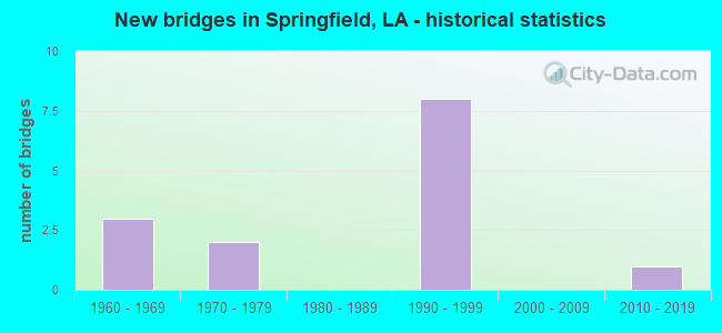
- New bridges - historical statistics
- 31960-1969
- 21970-1979
- 81990-1999
- 12010-2019


- Bridge Condition - Deck
- 9.1%Very good
- 54.5%Good
- 9.1%Satisfactory
- 27.3%Fair

- Bridge Condition - Superstructure
- 9.1%Very good
- 45.5%Good
- 9.1%Satisfactory
- 36.4%Fair

- Bridge Condition - Substructure
- 18.2%Very good
- 36.4%Good
- 9.1%Satisfactory
- 27.3%Fair
- 9.1%Poor

- Bridge Condition - Channel
- 7.1%Excellent
- 7.1%Very good
- 50.0%Good
- 21.4%Satisfactory
- 7.1%Fair
- 7.1%Serious
Find on map >> Show street view
Structure Number: 623200000620303, Location: 0.10 MILES EAST OF LA. 43 (Lat: 30.442161, Lng: -90.565311), Route carried "on" structure: County highway , Year Built: 1990, Year Reconstructed: 2005, Status: Posted for load, Structure Length: 1.13m (3.71ft), Design Load: H 20, Features Intersected: CREEK, Facility Carried by Structure: Willie Walker Rd
Minimum Vertical Clearance: 30+ m (98+ ft), Kilometerpoint: 0.000, Lanes on structure: 1, Owner: County Highway Agency, Approaching Roadway Width: 4.6m (15.1ft), Skew: 30 degrees, Material/Design: Wood or Timber, Design/Construction: Stringer/Multi-beam, Number Of Spans In Main Unit: 3, Length of Maximum Span: 5.8m (19.0ft), Curb-To-Curb Width: 4.5m (14.8ft), Out-to-Out Width: 4.9m (16.1ft)
Condition: Deck: Fair, Superstructure: Fair, Substructure: Fair, Channel: Satisfactory, Operating Rating: 27.2 metric tons, Method Used To Determine Operating Rating: Allowable Stress (AS), Inventory Rating: 20.0 metric tons, Method Used To Determine Inventory Rating: Allowable Stress (AS), Structural Evaluation: Somewhat better than minimum adequacy, Deck Geometry: Equal to present minimum criteria, Waterway Adequacy: Equal to present minimum criteria, Approach Roadway Alignment: Better than present minimum criteria, Designated Inspection Frequency: Every 24 months, Inspection Date: May 2021, Deck Structure Type: Wood or Timber, Wearing Surface/Protective System: Wearing Surface: Wood or Timber
Find on map >> Show street view
Structure Number: 623200000620305, Location: 0.70 MILES SOUTH OF LA.42 (Lat: 30.431269, Lng: -90.594650), Route carried "on" structure: County highway , Year Built: 1995, Status: Posted for load, Structure Length: 3.41m (11.19ft), Design Load: H 10, Features Intersected: BLOOD RIVER, Facility Carried by Structure: Ginny Ln
Minimum Vertical Clearance: 30+ m (98+ ft), Kilometerpoint: 0.000, Lanes on structure: 1, Owner: County Highway Agency, Approaching Roadway Width: 4.3m (14.1ft), Skew: 30 degrees, Material/Design: Wood or Timber, Design/Construction: Stringer/Multi-beam, Number Of Spans In Main Unit: 6, Length of Maximum Span: 5.8m (19.0ft), Curb-To-Curb Width: 4.4m (14.4ft), Out-to-Out Width: 4.6m (15.1ft)
Condition: Deck: Fair, Superstructure: Fair, Substructure: Fair, Channel: Fair, Operating Rating: 11.8 metric tons, Method Used To Determine Operating Rating: Allowable Stress (AS), Inventory Rating: 9.1 metric tons, Method Used To Determine Inventory Rating: Allowable Stress (AS), Structural Evaluation: High priority of replacement, Deck Geometry: Equal to present minimum criteria, Waterway Adequacy: Equal to present minimum criteria, Approach Roadway Alignment: Equal to present minimum criteria, Bridge Posting: Required (Relationship of Operating Rating to Maximum Legal Load: 30.0 - 39.9% below), Length Of Structure Improvement: 4.30m (14.11ft), Designated Inspection Frequency: Every 24 months, Other Special Inspection Frequency: Every 12 months, Inspection Date: May 2021, Other Special Inspection Date: May 2020, Bridge Improvement Cost: $256,000, Total Project Cost: $384,000 ( Estimate for 2016), Deck Structure Type: Wood or Timber, Wearing Surface/Protective System: Wearing Surface: Wood or Timber
Find on map >> Show street view
Structure Number: 623202610206281, Location: 1.0 M W OF LA 43 (Lat: 30.440089, Lng: -90.581100), Route carried "on" structure: State highway 42, Year Built: 1961, Status: Open, Structure Length: 2.44m (8.01ft), Average Daily Traffic: 2,100 (year 2016), Truck Traffic: 12%, Average Future Daily Traffic: 1,892 (year 2036), Design Load: HS 20, Features Intersected: LOBELL CREEK
Minimum Vertical Clearance: 30+ m (98+ ft), Kilometerpoint: 10.091, Lanes on structure: 2, Owner: State Highway Agency, Approaching Roadway Width: 9.1m (29.9ft), Material/Design: Concrete, Design/Construction: Slab, Number Of Spans In Main Unit: 4, Length of Maximum Span: 6.1m (20.0ft), Curb-To-Curb Width: 7.3m (24.0ft), Out-to-Out Width: 9.0m (29.5ft)
Condition: Deck: Good, Superstructure: Good, Substructure: Good, Channel: Good, Operating Rating: 39.0 metric tons, Method Used To Determine Operating Rating: Load Factor (LF), Inventory Rating: 23.6 metric tons, Method Used To Determine Inventory Rating: Load Factor (LF), Structural Evaluation: Equal to present minimum criteria, Deck Geometry: High priority of replacement, Waterway Adequacy: Better than present minimum criteria, Approach Roadway Alignment: Equal to present desirable criteria, Length Of Structure Improvement: 3.23m (10.60ft), Designated Inspection Frequency: Every 24 months, Inspection Date: January 2020, Bridge Improvement Cost: $275,000, Total Project Cost: $412,000 ( Estimate for 2016), Deck Structure Type: Concrete Cast-file-Place
Find on map >> Show street view
Structure Number: 623208322005241, Location: LA1037 (Lat: 30.422100, Lng: -90.583200), Route carried "on" structure: State highway 1037, Year Built: 1961, Status: Open, Structure Length: 3.66m (12.01ft), Average Daily Traffic: 1,730 (year 2016), Truck Traffic: 13%, Average Future Daily Traffic: 1,496 (year 2036), Design Load: HS 20, Features Intersected: BLOOD RIVER
Minimum Vertical Clearance: 30+ m (98+ ft), Kilometerpoint: 8.596, Lanes on structure: 2, Owner: State Highway Agency, Approaching Roadway Width: 8.8m (28.9ft), Material/Design: Concrete, Design/Construction: Slab, Number Of Spans In Main Unit: 6, Length of Maximum Span: 6.1m (20.0ft), Curb-To-Curb Width: 7.3m (24.0ft), Out-to-Out Width: 9.0m (29.5ft)
Condition: Deck: Good, Superstructure: Good, Substructure: Satisfactory, Channel: Good, Operating Rating: 40.8 metric tons, Method Used To Determine Operating Rating: Load Factor (LF), Inventory Rating: 24.5 metric tons, Method Used To Determine Inventory Rating: Load Factor (LF), Structural Evaluation: Equal to present minimum criteria, Deck Geometry: Meets minimum limits, Waterway Adequacy: Better than present minimum criteria, Approach Roadway Alignment: Equal to present desirable criteria, Designated Inspection Frequency: Every 24 months, Underwater Inspection Frequency: Every 60 months, Inspection Date: April 2020, Underwater Inspection Date: July 2019, Deck Structure Type: Concrete Cast-file-Place
Find on map >> Show street view
Structure Number: 623230259903501, Location: .7 SO OF LA 42 (Lat: 30.431019, Lng: -90.583661), Route carried "on" structure: County highway , Year Built: 1997, Status: Open, Structure Length: 2.32m (7.61ft), Average Daily Traffic: 100 (year 1997), Average Future Daily Traffic: 86 (year 2036), Design Load: HS 20, Features Intersected: BREED CREEK BRIDGE, Facility Carried by Structure: Richardson Rd
Minimum Vertical Clearance: 30+ m (98+ ft), Kilometerpoint: 0.000, Lanes on structure: 2, Base Highway Network: Yes, Owner: County Highway Agency, Approaching Roadway Width: 7.3m (24.0ft), Material/Design: Concrete, Design/Construction: Slab, Number Of Spans In Main Unit: 4, Length of Maximum Span: 5.8m (19.0ft), Curb-To-Curb Width: 7.3m (24.0ft), Out-to-Out Width: 8.1m (26.6ft)
Condition: Deck: Good, Superstructure: Good, Substructure: Good, Channel: Satisfactory, Operating Rating: 51.5 metric tons, Method Used To Determine Operating Rating: Load and Resistance Factor Rating (LRFR) rating reported by rating factor(RF) method using HL-93 loadings, Inventory Rating: 39.9 metric tons, Method Used To Determine Inventory Rating: Load and Resistance Factor Rating (LRFR) rating reported by rating factor(RF) method using HL-93 loadings, Structural Evaluation: Better than present minimum criteria, Deck Geometry: Equal to present minimum criteria, Waterway Adequacy: Better than present minimum criteria, Approach Roadway Alignment: Equal to present desirable criteria, Designated Inspection Frequency: Every 24 months, Inspection Date: August 2020, Deck Structure Type: Concrete Cast-file-Place
Find on map >> Show street view
Structure Number: 623230260903291, Location: 4.0 MI SE OF EXIT 43 (Lat: 30.431950, Lng: -90.547311), Route carried "on" structure: County highway , Year Built: 1960, Status: Posted for load, Structure Length: 0.94m (3.08ft), Average Daily Traffic: 280 (year 1974), Average Future Daily Traffic: 240 (year 2036), Design Load: H 15, Features Intersected: CREEK, Facility Carried by Structure: McCarrol Rd
Minimum Vertical Clearance: 30+ m (98+ ft), Kilometerpoint: 0.000, Lanes on structure: 2, Owner: Town or Township Highway Agency, Approaching Roadway Width: 6.4m (21.0ft), Material/Design: Wood or Timber, Design/Construction: Stringer/Multi-beam, Number Of Spans In Main Unit: 2, Length of Maximum Span: 4.6m (15.1ft), Curb-To-Curb Width: 5.8m (19.0ft), Out-to-Out Width: 6.6m (21.7ft)
Condition: Deck: Satisfactory, Superstructure: Satisfactory, Substructure: Fair, Channel: Serious, Operating Rating: 20.9 metric tons, Method Used To Determine Operating Rating: Allowable Stress (AS), Inventory Rating: 15.4 metric tons, Method Used To Determine Inventory Rating: Allowable Stress (AS), Structural Evaluation: Meets minimum limits, Deck Geometry: High priority of corrective action, Waterway Adequacy: High priority of corrective action, Approach Roadway Alignment: Somewhat better than minimum adequacy, Length Of Structure Improvement: 1.59m (5.22ft), Designated Inspection Frequency: Every 24 months, Inspection Date: July 2020, Bridge Improvement Cost: $94,000, Total Project Cost: $141,000 ( Estimate for 2016), Deck Structure Type: Wood or Timber, Wearing Surface/Protective System: Wearing Surface: Bituminous
Find on map >> Show street view
Structure Number: 623230260903551, Location: 2 MILES W OF JCT 42 & 43 (Lat: 30.433969, Lng: -90.591050), Route carried "on" structure: County highway , Year Built: 1994, Status: Open, Structure Length: 0.82m (2.69ft), Average Daily Traffic: 50 (year 2016), Average Future Daily Traffic: 43 (year 2036), Design Load: HS 20, Features Intersected: RICHARDSON DRIVE BRIDGE, Facility Carried by Structure: Richardson Rd
Minimum Vertical Clearance: 30+ m (98+ ft), Kilometerpoint: 0.000, Lanes on structure: 2, Owner: County Highway Agency, Approaching Roadway Width: 7.3m (24.0ft), Material/Design: Concrete, Design/Construction: Culvert, Number Of Spans In Main Unit: 4, Length of Maximum Span: 1.8m (5.9ft)
Condition: Channel: Very good, Culverts: Good, Operating Rating: 42.1 metric tons, Method Used To Determine Operating Rating: Load and Resistance Factor Rating (LRFR) rating reported by rating factor(RF) method using HL-93 loadings, Inventory Rating: 32.4 metric tons, Method Used To Determine Inventory Rating: Load and Resistance Factor Rating (LRFR) rating reported by rating factor(RF) method using HL-93 loadings, Structural Evaluation: Better than present minimum criteria, Waterway Adequacy: Better than present minimum criteria, Approach Roadway Alignment: Equal to present desirable criteria, Designated Inspection Frequency: Every 24 months, Inspection Date: August 2020, Deck Structure Type: Concrete Cast-file-Place
Find on map >> Show street view
Structure Number: 623230262903341, Location: 0.15 M N of LA 42 (Lat: 30.438131, Lng: -90.557819), Route carried "on" structure: County highway , Year Built: 1990, Status: Open, Structure Length: 0.70m (2.30ft), Average Daily Traffic: 150 (year 1988), Average Future Daily Traffic: 129 (year 2036), Design Load: HS 20, Features Intersected: CREEK, Facility Carried by Structure: Pardue Rd
Minimum Vertical Clearance: 30+ m (98+ ft), Kilometerpoint: 0.000, Lanes on structure: 2, Owner: County Highway Agency, Approaching Roadway Width: 5.5m (18.0ft), Material/Design: Concrete, Design/Construction: Culvert, Number Of Spans In Main Unit: 4, Length of Maximum Span: 1.5m (4.9ft)
Condition: Channel: Good, Culverts: Good, Operating Rating: 42.1 metric tons, Method Used To Determine Operating Rating: Load and Resistance Factor Rating (LRFR) rating reported by rating factor(RF) method using HL-93 loadings, Inventory Rating: 32.4 metric tons, Method Used To Determine Inventory Rating: Load and Resistance Factor Rating (LRFR) rating reported by rating factor(RF) method using HL-93 loadings, Structural Evaluation: Better than present minimum criteria, Waterway Adequacy: Somewhat better than minimum adequacy, Approach Roadway Alignment: Equal to present desirable criteria, Designated Inspection Frequency: Every 24 months, Inspection Date: August 2020, Deck Structure Type: Concrete Cast-file-Place
Find on map >> Show street view
Structure Number: 625300000620356, Location: .65 MI. E. OF LA 1249 (Lat: 30.451350, Lng: -90.531350), Route carried "on" structure: County highway , Year Built: 2018, Status: Open, Structure Length: 2.44m (8.01ft), Average Daily Traffic: 850 (year 2015), Average Future Daily Traffic: 935 (year 2035), Design Load: Greater than HL93, Features Intersected: CREEK, Facility Carried by Structure: JERUSALEM CHUR. RD
Minimum Vertical Clearance: 30+ m (98+ ft), Kilometerpoint: 1.036, Lanes on structure: 2, Owner: County Highway Agency, Approaching Roadway Width: 8.8m (28.9ft), Skew: 1 degrees, Material/Design: Concrete, Design/Construction: Slab, Number Of Spans In Main Unit: 4, Length of Maximum Span: 6.1m (20.0ft), Curb-To-Curb Width: 8.8m (28.9ft), Out-to-Out Width: 9.6m (31.5ft)
Condition: Deck: Very good, Superstructure: Very good, Substructure: Very good, Channel: Excellent, Operating Rating: 57.7 metric tons, Method Used To Determine Operating Rating: Load and Resistance Factor Rating (LRFR) rating reported by rating factor(RF) method using HL-93 loadings, Inventory Rating: 44.4 metric tons, Method Used To Determine Inventory Rating: Load and Resistance Factor Rating (LRFR) rating reported by rating factor(RF) method using HL-93 loadings, Structural Evaluation: Equal to present desirable criteria, Deck Geometry: Somewhat better than minimum adequacy, Waterway Adequacy: Better than present minimum criteria, Approach Roadway Alignment: Better than present minimum criteria, Designated Inspection Frequency: Every 24 months, Inspection Date: July 2021, Deck Structure Type: Concrete Cast-file-Place
Find on map >> Show street view
Structure Number: 625302610302101, Location: 3.0 M W OF I-55 (Lat: 30.438889, Lng: -90.513400), Route carried "on" structure: State highway 22, Year Built: 1976, Status: Open, Structure Length: 1.83m (6.00ft), Average Daily Traffic: 15,100 (year 2016), Truck Traffic: 8%, Average Future Daily Traffic: 11,200 (year 2036), Design Load: HS 20, Features Intersected: DRAIN
Minimum Vertical Clearance: 30+ m (98+ ft), Kilometerpoint: 3.537, Lanes on structure: 2, Owner: State Highway Agency, Approaching Roadway Width: 13.4m (44.0ft), Material/Design: Concrete, Design/Construction: Slab, Number Of Spans In Main Unit: 3, Length of Maximum Span: 6.1m (20.0ft), Curb-To-Curb Width: 13.4m (44.0ft), Out-to-Out Width: 14.4m (47.2ft)
Condition: Deck: Good, Superstructure: Good, Substructure: Good, Channel: Good, Operating Rating: 71.7 metric tons, Method Used To Determine Operating Rating: Load Factor (LF), Inventory Rating: 42.6 metric tons, Method Used To Determine Inventory Rating: Load Factor (LF), Structural Evaluation: Better than present minimum criteria, Deck Geometry: Equal to present minimum criteria, Waterway Adequacy: Equal to present desirable criteria, Approach Roadway Alignment: Equal to present desirable criteria, Designated Inspection Frequency: Every 24 months, Inspection Date: March 2021, Deck Structure Type: Concrete Cast-file-Place
Find on map >> Show street view
Structure Number: 625308532100431, Location: 3MISPUMPKINCTR XIT PUMPCT (Lat: 30.442100, Lng: -90.542200), Route carried "on" structure: State highway 1249, Year Built: 1994, Status: Posted for load, Structure Length: 2.19m (7.19ft), Average Daily Traffic: 5,900 (year 2016), Truck Traffic: 8%, Average Future Daily Traffic: 4,620 (year 2036), Design Load: HS 20, Features Intersected: CREEK
Minimum Vertical Clearance: 30+ m (98+ ft), Kilometerpoint: 0.681, Lanes on structure: 2, Owner: State Highway Agency, Approaching Roadway Width: 6.7m (22.0ft), Material/Design: Steel, Design/Construction: Stringer/Multi-beam, Number Of Spans In Main Unit: 3, Length of Maximum Span: 11.9m (39.0ft), Curb-To-Curb Width: 7.5m (24.6ft), Out-to-Out Width: 7.9m (25.9ft)
Condition: Deck: Good, Superstructure: Fair, Substructure: Good, Channel: Good, Operating Rating: 33.6 metric tons, Method Used To Determine Operating Rating: Load Factor (LF), Inventory Rating: 20.0 metric tons, Method Used To Determine Inventory Rating: Load Factor (LF), Structural Evaluation: Somewhat better than minimum adequacy, Deck Geometry: High priority of replacement, Waterway Adequacy: Better than present minimum criteria, Approach Roadway Alignment: Equal to present desirable criteria, Bridge Posting: Required (Relationship of Operating Rating to Maximum Legal Load: 10.0 - 19.9% below), Length Of Structure Improvement: 2.96m (9.71ft), Designated Inspection Frequency: Every 24 months, Inspection Date: March 2021, Bridge Improvement Cost: $252,000, Total Project Cost: $378,000 ( Estimate for 2016), Deck Structure Type: Open Grating, Wearing Surface/Protective System: Wearing Surface: Bituminous
Find on map >> Show street view
Structure Number: 625308532100901, Location: 2.5 MI S. PUMPKIN C EXIT (Lat: 30.448769, Lng: -90.542211), Route carried "on" structure: State highway 1249, Year Built: 1995, Status: Open, Structure Length: 0.67m (2.20ft), Average Daily Traffic: 5,900 (year 2016), Truck Traffic: 8%, Average Future Daily Traffic: 4,620 (year 2036), Design Load: HS 20, Features Intersected: PIPE AT CANAL
Minimum Vertical Clearance: 30+ m (98+ ft), Kilometerpoint: 1.448, Lanes on structure: 2, Owner: State Highway Agency, Approaching Roadway Width: 7.0m (23.0ft), Material/Design: Steel, Design/Construction: Culvert, Length of Maximum Span: 0.0m
Condition: Channel: Good, Culverts: Good, Operating Rating: 62.9 metric tons, Method Used To Determine Operating Rating: Load and Resistance Factor Rating (LRFR) rating reported by rating factor(RF) method using HL-93 loadings, Inventory Rating: 48.6 metric tons, Method Used To Determine Inventory Rating: Load and Resistance Factor Rating (LRFR) rating reported by rating factor(RF) method using HL-93 loadings, Structural Evaluation: Better than present minimum criteria, Waterway Adequacy: Better than present minimum criteria, Approach Roadway Alignment: Equal to present desirable criteria, Designated Inspection Frequency: Every 24 months, Inspection Date: April 2021, Deck Structure Type: Other
Find on map >> Show street view
Structure Number: 625330255902981, Location: 3.5 MI SW OF SR 22 EXIT (Lat: 30.425350, Lng: -90.493361), Route carried "on" structure: County highway , Year Built: 1999, Status: Open, Structure Length: 4.05m (13.29ft), Average Daily Traffic: 300 (year 2016), Average Future Daily Traffic: 210 (year 2036), Design Load: HS 20, Features Intersected: CREEK, Facility Carried by Structure: Wadesboro Rd
Minimum Vertical Clearance: 30+ m (98+ ft), Kilometerpoint: 0.000, Lanes on structure: 2, Base Highway Network: Yes, Owner: County Highway Agency, Approaching Roadway Width: 8.5m (27.9ft), Material/Design: Concrete, Design/Construction: Slab, Number Of Spans In Main Unit: 7, Length of Maximum Span: 5.8m (19.0ft), Curb-To-Curb Width: 7.3m (24.0ft), Out-to-Out Width: 8.1m (26.6ft)
Condition: Deck: Good, Superstructure: Good, Substructure: Very good, Channel: Good, Operating Rating: 51.2 metric tons, Method Used To Determine Operating Rating: Load and Resistance Factor Rating (LRFR) rating reported by rating factor(RF) method using HL-93 loadings, Inventory Rating: 39.5 metric tons, Method Used To Determine Inventory Rating: Load and Resistance Factor Rating (LRFR) rating reported by rating factor(RF) method using HL-93 loadings, Structural Evaluation: Better than present minimum criteria, Deck Geometry: Somewhat better than minimum adequacy, Waterway Adequacy: Better than present minimum criteria, Approach Roadway Alignment: Equal to present minimum criteria, Designated Inspection Frequency: Every 24 months, Inspection Date: April 2021, Deck Structure Type: Concrete Cast-file-Place, Wearing Surface/Protective System: Wearing Surface: Monolithic Concrete
Find on map >> Show street view
Structure Number: 625330261903131, Location: 4.5 MI SW OF SR 22 E (Lat: 30.435219, Lng: -90.521250), Route carried "on" structure: County highway , Year Built: 1975, Status: Posted for load, Structure Length: 1.19m (3.90ft), Average Daily Traffic: 512 (year 2021), Average Future Daily Traffic: 564 (year 2041), Design Load: H 10, Features Intersected: CREEK, Facility Carried by Structure: Rosaryville Rd
Minimum Vertical Clearance: 30+ m (98+ ft), Kilometerpoint: 0.000, Lanes on structure: 2, Owner: County Highway Agency, Approaching Roadway Width: 6.1m (20.0ft), Material/Design: Wood or Timber, Design/Construction: Stringer/Multi-beam, Number Of Spans In Main Unit: 2, Length of Maximum Span: 5.8m (19.0ft), Curb-To-Curb Width: 6.1m (20.0ft), Out-to-Out Width: 7.1m (23.3ft)
Condition: Deck: Fair, Superstructure: Fair, Substructure: Poor, Channel: Satisfactory, Operating Rating: 14.5 metric tons, Method Used To Determine Operating Rating: Allowable Stress (AS), Inventory Rating: 9.1 metric tons, Method Used To Determine Inventory Rating: Allowable Stress (AS), Structural Evaluation: High priority of corrective action, Deck Geometry: High priority of corrective action, Waterway Adequacy: Better than present minimum criteria, Approach Roadway Alignment: Better than present minimum criteria, Bridge Posting: Required (Relationship of Operating Rating to Maximum Legal Load: 30.0 - 39.9% below), Designated Inspection Frequency: Every 24 months, Other Special Inspection Frequency: Every 12 months, Inspection Date: April 2021, Other Special Inspection Date: April 2020, Deck Structure Type: Wood or Timber, Wearing Surface/Protective System: Wearing Surface: Bituminous