Bridge Statistics for Springfield, Pennsylvania (PA)
Condition, Traffic, Stress, Structural Evaluation, Project Costs
- National Bridge Inventory (NBI) Statistics
- 18Number of bridges
- 217ft / 66.3mTotal length
- $1,482,000Total costs
- 317,689Total average daily traffic
- 25,822Total average daily truck traffic
- National Bridge Inventory (NBI) Registered Bridges for Springfield
- No street view available for this location
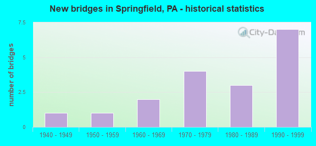
- New bridges - historical statistics
- 11940-1949
- 11950-1959
- 21960-1969
- 41970-1979
- 31980-1989
- 71990-1999
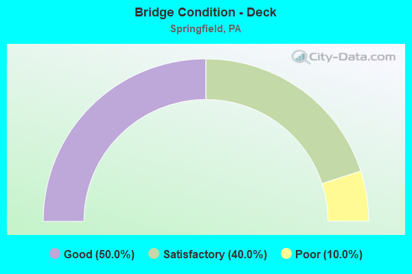
- Bridge Condition - Deck
- 50.0%Good
- 40.0%Satisfactory
- 10.0%Poor
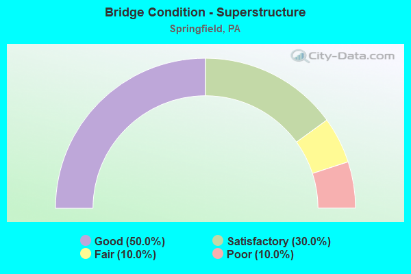
- Bridge Condition - Superstructure
- 50.0%Good
- 30.0%Satisfactory
- 10.0%Fair
- 10.0%Poor
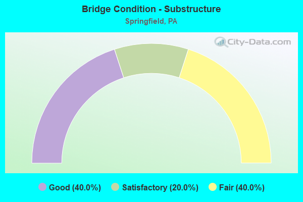
- Bridge Condition - Substructure
- 40.0%Good
- 20.0%Satisfactory
- 40.0%Fair
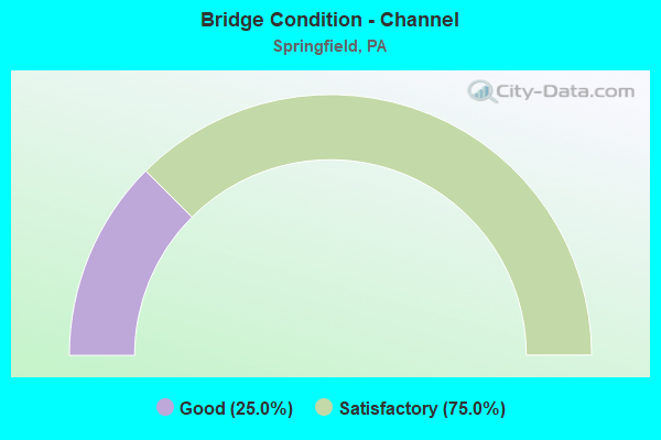
- Bridge Condition - Channel
- 25.0%Good
- 75.0%Satisfactory
Find on map >> Show street view
Structure Number: 366, Location: 1 MI N OF ARENDTSVILLE (Lat: 39.933567, Lng: -77.302678), Route carried "on" structure: State highway , Year Built: 1957, Status: Open, Structure Length: 1.77m (5.81ft), Average Daily Traffic: 1,146 (year 2022), Truck Traffic: 6%, Average Future Daily Traffic: 1,733 (year 2032), Design Load: HS 20, Features Intersected: CONEWAGO CREEK, Facility Carried by Structure: SR 4008
Minimum Vertical Clearance: 30+ m (98+ ft), Kilometerpoint: 0.000, Lanes on structure: 2, Owner: State Highway Agency, Approaching Roadway Width: 6.7m (22.0ft), Skew: 1 degrees, Material/Design: Steel, Design/Construction: Stringer/Multi-beam, Number Of Spans In Main Unit: 1, Length of Maximum Span: 15.8m (51.8ft), Curb or Sidewalk Widths: Left: 0.5m (1.6ft), Right: 0.5m (1.6ft), Curb-To-Curb Width: 9.1m (29.9ft), Out-to-Out Width: 10.8m (35.4ft)
Condition: Deck: Satisfactory, Superstructure: Fair, Substructure: Good, Channel: Satisfactory, Operating Rating: 58.1 metric tons, Method Used To Determine Operating Rating: Load Factor (LF), Inventory Rating: 34.5 metric tons, Method Used To Determine Inventory Rating: Load Factor (LF), Structural Evaluation: Somewhat better than minimum adequacy, Deck Geometry: Somewhat better than minimum adequacy, Waterway Adequacy: Better than present minimum criteria, Approach Roadway Alignment: Equal to present desirable criteria, Length Of Structure Improvement: 2.50m (8.20ft), Designated Inspection Frequency: Every 24 months, Inspection Date: April 2021, Bridge Improvement Cost: $6,000, Roadway Improvement Cost: $18,000, Total Project Cost: $83,000, Deck Structure Type: Concrete Cast-file-Place, Wearing Surface/Protective System: Wearing Surface: Bituminous
Find on map >> Show street view
Structure Number: 14966, Location: 1MI.TO CHESTER 34H11 (Lat: 39.887236, Lng: -75.355744), Route carried "on" structure: State highway 320, Year Built: 1989, Status: Open, Structure Length: 20.91m (68.60ft), Average Daily Traffic: 7,955 (year 2021), Truck Traffic: 4%, Average Future Daily Traffic: 10,492 (year 2032), Design Load: HS 25 or greater, Features Intersected: MID-COUNTY EXWY;CRUM CK., Facility Carried by Structure: CHESTER ROAD
Minimum Vertical Clearance: 30+ m (98+ ft), Kilometerpoint: 4.435, Lanes on structure: 2, Lanes under structure: 5, Base Highway Network: Yes, Owner: State Highway Agency, Approaching Roadway Width: 13.4m (44.0ft), Material/Design: Steel continuous, Design/Construction: Stringer/Multi-beam, Number Of Spans In Main Unit: 4, Length of Maximum Span: 57.3m (188.0ft), Curb or Sidewalk Widths: Left: 1.8m (5.9ft), Right: 0.2m (0.7ft), Curb-To-Curb Width: 13.4m (44.0ft), Out-to-Out Width: 15.9m (52.2ft)
Condition: Deck: Good, Superstructure: Good, Substructure: Satisfactory, Channel: Satisfactory, Operating Rating: 55.3 metric tons, Method Used To Determine Operating Rating: Load Factor (LF), Inventory Rating: 33.6 metric tons, Method Used To Determine Inventory Rating: Load Factor (LF), Structural Evaluation: Equal to present minimum criteria, Deck Geometry: Equal to present minimum criteria, Underclear: Better than present minimum criteria, Waterway Adequacy: Superior to present desirable criteria, Approach Roadway Alignment: Equal to present desirable criteria, Length Of Structure Improvement: 21.50m (70.54ft), Designated Inspection Frequency: Every 24 months, Inspection Date: March 2020, Deck Structure Type: Concrete Cast-file-Place, Wearing Surface/Protective System: Wearing Surface: Monolithic Concrete, Deck Protection: Epoxy Coated Reinforcing
Find on map >> Show street view
Structure Number: 14969, Location: .5MI.N.BALTIMORE 34J05 (Lat: 39.918603, Lng: -75.348572), Route carried "on" structure: State highway 320, Year Built: 1949, Year Reconstructed: 1986, Status: Open, Structure Length: 8.08m (26.51ft), Average Daily Traffic: 16,889 (year 2022), Truck Traffic: 4%, Average Future Daily Traffic: 17,533 (year 2032), Design Load: HS 20+Mod, Features Intersected: WHISKEY RUN & SEPTA, Facility Carried by Structure: SPROUL ROAD
Minimum Vertical Clearance: 30+ m (98+ ft), Kilometerpoint: 8.068, Lanes on structure: 2, Base Highway Network: Yes, Owner: State Highway Agency, Approaching Roadway Width: 11.0m (36.1ft), Skew: 5 degrees, Material/Design: Steel continuous, Design/Construction: Stringer/Multi-beam, Number Of Spans In Main Unit: 4, Length of Maximum Span: 21.9m (71.9ft), Curb or Sidewalk Widths: Left: 1.5m (4.9ft), Right: 1.5m (4.9ft), Curb-To-Curb Width: 10.1m (33.1ft), Out-to-Out Width: 13.7m (44.9ft)
Condition: Deck: Good, Superstructure: Satisfactory, Substructure: Satisfactory, Channel: Good, Operating Rating: 69.9 metric tons, Method Used To Determine Operating Rating: Load Factor (LF), Inventory Rating: 41.7 metric tons, Method Used To Determine Inventory Rating: Load Factor (LF), Structural Evaluation: Equal to present minimum criteria, Deck Geometry: Meets minimum limits, Underclear: High priority of corrective action, Waterway Adequacy: Superior to present desirable criteria, Approach Roadway Alignment: Equal to present desirable criteria, Length Of Structure Improvement: 8.90m (29.20ft), Designated Inspection Frequency: Every 24 months, Inspection Date: October 2020, Deck Structure Type: Concrete Cast-file-Place, Wearing Surface/Protective System: Wearing Surface: Monolithic Concrete, Deck Protection: Epoxy Coated Reinforcing
Find on map >> Show street view
Structure Number: 1497, Location: SPRINGFIELD TWP 3587D10 (Lat: 39.938242, Lng: -75.350483), Route carried "on" structure: State highway 320, Year Built: 1977, Status: Open, Structure Length: 3.60m (11.81ft), Average Daily Traffic: 22,176 (year 2022), Truck Traffic: 5%, Average Future Daily Traffic: 38,370 (year 2032), Design Load: HS 20, Features Intersected: US-1 BYPASS, Facility Carried by Structure: SPROUL ROAD
Minimum Vertical Clearance: 30+ m (98+ ft), Kilometerpoint: 9.793, Lanes on structure: 2, Lanes under structure: 4, Base Highway Network: Yes, Owner: State Highway Agency, Approaching Roadway Width: 25.6m (84.0ft), Skew: 24 degrees, Material/Design: Steel, Design/Construction: Stringer/Multi-beam, Number Of Spans In Main Unit: 1, Length of Maximum Span: 34.1m (111.9ft), Curb or Sidewalk Widths: Left: 1.5m (4.9ft), Right: 1.5m (4.9ft), Curb-To-Curb Width: 25.6m (84.0ft), Out-to-Out Width: 29.4m (96.5ft)
Condition: Deck: Satisfactory, Superstructure: Satisfactory, Substructure: Fair, Inventory Rating: 62.6 metric tons, Method Used To Determine Inventory Rating: Load Factor (LF), Structural Evaluation: Somewhat better than minimum adequacy, Deck Geometry: Superior to present desirable criteria, Underclear: High priority of corrective action, Approach Roadway Alignment: Equal to present desirable criteria, Length Of Structure Improvement: 4.50m (14.76ft), Designated Inspection Frequency: Every 24 months, Inspection Date: July 2020, Bridge Improvement Cost: $100,000, Roadway Improvement Cost: $295,000, Total Project Cost: $1,351,000, Deck Structure Type: Concrete Cast-file-Place, Wearing Surface/Protective System: Wearing Surface: Monolithic Concrete, Deck Protection: Galvanized Reinforcing
Find on map >> Show street view
Structure Number: 15059, Location: SMEDLEY PARK 34G04 (Lat: 39.923489, Lng: -75.362550), Route carried "on" structure: Interstate 476, Year Built: 1990, Status: Open, Structure Length: 16.64m (54.59ft), Average Daily Traffic: 41,876 (year 2021), Truck Traffic: 9%, Average Future Daily Traffic: 58,525 (year 2032), Design Load: HS 25 or greater, Features Intersected: CRUM CREEK, Facility Carried by Structure: MID-COUNTY EXWY.SB
Minimum Vertical Clearance: 30+ m (98+ ft), Kilometerpoint: 5.620, Lanes on structure: 2, Base Highway Network: Yes, Owner: State Highway Agency, Approaching Roadway Width: 16.5m (54.1ft), Skew: 14 degrees, Material/Design: Steel continuous, Design/Construction: Stringer/Multi-beam, Number Of Spans In Main Unit: 3, Length of Maximum Span: 54.9m (180.1ft), Curb or Sidewalk Widths: Left: 0.2m (0.7ft), Right: 0.2m (0.7ft), Curb-To-Curb Width: 16.6m (54.5ft), Out-to-Out Width: 17.6m (57.7ft)
Condition: Deck: Satisfactory, Superstructure: Good, Substructure: Good, Channel: Satisfactory, Operating Rating: 82.6 metric tons, Method Used To Determine Operating Rating: Load Factor (LF), Inventory Rating: 49.0 metric tons, Method Used To Determine Inventory Rating: Load Factor (LF), Structural Evaluation: Better than present minimum criteria, Deck Geometry: Superior to present desirable criteria, Waterway Adequacy: Superior to present desirable criteria, Approach Roadway Alignment: Better than present minimum criteria, Length Of Structure Improvement: 17.50m (57.41ft), Designated Inspection Frequency: Every 24 months, Inspection Date: December 2019, Deck Structure Type: Concrete Cast-file-Place, Wearing Surface/Protective System: Wearing Surface: Latex Concrete, Deck Protection: Epoxy Coated Reinforcing
Find on map >> Show street view
Structure Number: 15266, Location: 2MI.WEST PA 320 34F04 (Lat: 39.925494, Lng: -75.365494), Route carried "on" structure: State highway , Year Built: 1973, Status: Open, Structure Length: 2.90m (9.51ft), Average Daily Traffic: 4,949 (year 2022), Truck Traffic: 5%, Average Future Daily Traffic: 3,711 (year 2032), Design Load: HS 20, Features Intersected: CRUM CREEK, Facility Carried by Structure: BEATTY ROAD
Minimum Vertical Clearance: 30+ m (98+ ft), Kilometerpoint: 1.646, Lanes on structure: 2, Owner: State Highway Agency, Approaching Roadway Width: 10.4m (34.1ft), Skew: 4 degrees, Material/Design: Steel, Design/Construction: Stringer/Multi-beam, Number Of Spans In Main Unit: 1, Length of Maximum Span: 26.8m (87.9ft), Curb or Sidewalk Widths: Left: 1.5m (4.9ft), Right: 0.2m (0.7ft), Curb-To-Curb Width: 9.1m (29.9ft), Out-to-Out Width: 11.7m (38.4ft)
Condition: Deck: Good, Superstructure: Satisfactory, Substructure: Fair, Channel: Satisfactory, Inventory Rating: 61.7 metric tons, Method Used To Determine Inventory Rating: Load Factor (LF), Structural Evaluation: Somewhat better than minimum adequacy, Deck Geometry: Meets minimum limits, Waterway Adequacy: Better than present minimum criteria, Approach Roadway Alignment: Better than present minimum criteria, Length Of Structure Improvement: 3.50m (11.48ft), Designated Inspection Frequency: Every 24 months, Inspection Date: November 2019, Deck Structure Type: Concrete Cast-file-Place, Wearing Surface/Protective System: Wearing Surface: Monolithic Concrete
Find on map >> Show street view
Structure Number: 15267, Location: SMEDLEY PARK 34G03 (Lat: 39.928731, Lng: -75.362569), Route carried "on" structure: State highway , Year Built: 1990, Status: Open, Structure Length: 6.31m (20.70ft), Average Daily Traffic: 4,949 (year 2022), Truck Traffic: 5%, Average Future Daily Traffic: 3,711 (year 2032), Design Load: HS 25 or greater, Features Intersected: MID-COUNTY EXPRESSWAY, Facility Carried by Structure: BEATTY ROAD
Minimum Vertical Clearance: 30+ m (98+ ft), Kilometerpoint: 2.124, Lanes on structure: 2, Lanes under structure: 4, Owner: State Highway Agency, Approaching Roadway Width: 9.8m (32.2ft), Skew: 4 degrees, Material/Design: Prestressed concrete continuous, Design/Construction: Stringer/Multi-beam, Number Of Spans In Main Unit: 2, Length of Maximum Span: 30.2m (99.1ft), Curb or Sidewalk Widths: Left: 0.2m (0.7ft), Right: 1.5m (4.9ft), Curb-To-Curb Width: 9.8m (32.2ft), Out-to-Out Width: 12.1m (39.7ft)
Condition: Deck: Good, Superstructure: Good, Substructure: Good, Operating Rating: 99.8 metric tons, Method Used To Determine Operating Rating: Load Factor (LF), Inventory Rating: 31.8 metric tons, Method Used To Determine Inventory Rating: Load Factor (LF), Structural Evaluation: Better than present minimum criteria, Deck Geometry: Meets minimum limits, Underclear: Superior to present desirable criteria, Approach Roadway Alignment: Better than present minimum criteria, Length Of Structure Improvement: 7.20m (23.62ft), Designated Inspection Frequency: Every 24 months, Inspection Date: June 2020, Deck Structure Type: Concrete Cast-file-Place, Wearing Surface/Protective System: Wearing Surface: Monolithic Concrete, Deck Protection: Epoxy Coated Reinforcing
Find on map >> Show street view
Structure Number: 15375, Location: .3 Mi N of Balt Pk 20-D7 (Lat: 39.915464, Lng: -75.359647), Route carried "on" structure: ServiceOther road , Year Built: 1991, Status: Open, Structure Length: 4.48m (14.70ft), Average Daily Traffic: 129 (year 2017), Truck Traffic: 2%, Average Future Daily Traffic: 161 (year 2032), Design Load: HS 25 or greater, Features Intersected: CRUM CREEK, Facility Carried by Structure: SMEDLEY PARK ENT.
Minimum Vertical Clearance: 30+ m (98+ ft), Kilometerpoint: 0.000, Lanes on structure: 1, Owner: County Highway Agency, Approaching Roadway Width: 7.9m (25.9ft), Skew: 5 degrees, Material/Design: Steel continuous, Design/Construction: Girder and Floorbeam System, Number Of Spans In Main Unit: 1, Length of Maximum Span: 21.3m (69.9ft), Curb or Sidewalk Widths: Left: 1.5m (4.9ft), Right: 0.2m (0.7ft), Curb-To-Curb Width: 4.6m (15.1ft), Out-to-Out Width: 7.0m (23.0ft)
Condition: Deck: Satisfactory, Superstructure: Good, Substructure: Good, Channel: Good, Inventory Rating: 68.0 metric tons, Method Used To Determine Inventory Rating: Load Factor (LF), Structural Evaluation: Better than present minimum criteria, Deck Geometry: High priority of replacement, Waterway Adequacy: Superior to present desirable criteria, Approach Roadway Alignment: Somewhat better than minimum adequacy, Length Of Structure Improvement: 5.40m (17.72ft), Designated Inspection Frequency: Every 24 months, Critical Feature Inspection Frequency: Every 24 months, Inspection Date: December 2019, Critical Feature Inspection Date: December 2019, Deck Structure Type: Concrete Cast-file-Place, Wearing Surface/Protective System: Wearing Surface: Monolithic Concrete, Deck Protection: Epoxy Coated Reinforcing
Find on map >> Show street view
Structure Number: 15384, Location: 1 Mi E SR320 ADC 21-A1 (Lat: 39.954400, Lng: -75.336000), Route carried "on" structure: County highway , Year Built: 1962, Status: Open, Structure Length: 0.85m (2.79ft), Average Daily Traffic: 16,742 (year 2017), Truck Traffic: 13%, Average Future Daily Traffic: 20,928 (year 2032), Design Load: H 20, Features Intersected: WHETSTONE RUN, Facility Carried by Structure: REED ROAD
Minimum Vertical Clearance: 30+ m (98+ ft), Kilometerpoint: 0.000, Lanes on structure: 3, Owner: County Highway Agency, Approaching Roadway Width: 13.1m (43.0ft), Skew: 3 degrees, Material/Design: Concrete, Design/Construction: Tee Beam, Number Of Spans In Main Unit: 1, Length of Maximum Span: 8.5m (27.9ft), Curb or Sidewalk Widths: Left: 1.5m (4.9ft), Right: 1.5m (4.9ft), Curb-To-Curb Width: 12.6m (41.3ft), Out-to-Out Width: 16.5m (54.1ft)
Condition: Deck: Good, Superstructure: Good, Substructure: Fair, Channel: Satisfactory, Operating Rating: 40.8 metric tons, Method Used To Determine Operating Rating: Load Factor (LF), Inventory Rating: 24.5 metric tons, Method Used To Determine Inventory Rating: Load Factor (LF), Structural Evaluation: Somewhat better than minimum adequacy, Deck Geometry: Meets minimum limits, Waterway Adequacy: Superior to present desirable criteria, Approach Roadway Alignment: Better than present minimum criteria, Length Of Structure Improvement: 0.90m (2.95ft), Designated Inspection Frequency: Every 24 months, Inspection Date: October 2019, Bridge Improvement Cost: $4,000, Roadway Improvement Cost: $10,000, Total Project Cost: $48,000, Deck Structure Type: Concrete Cast-file-Place, Wearing Surface/Protective System: Wearing Surface: Bituminous
Find on map >> Show street view
Structure Number: 15434, Location: 0.1M N SR2016 ADC 3697-C4 (Lat: 39.914475, Lng: -75.357656), Route carried "on" structure: City street , Year Built: 1965, Status: Posted for load, Structure Length: 0.73m (2.40ft), Average Daily Traffic: 200 (year 2018), Truck Traffic: 5%, Average Future Daily Traffic: 250 (year 2038), Design Load: H 20, Features Intersected: WHISKEY RUN, Facility Carried by Structure: PAPER MILL ROAD
Minimum Vertical Clearance: 30+ m (98+ ft), Kilometerpoint: 0.000, Lanes on structure: 2, Owner: Town or Township Highway Agency, Approaching Roadway Width: 7.3m (24.0ft), Skew: 1 degrees, Material/Design: Prestressed concrete, Design/Construction: Box Beam or Girders - Multiple, Number Of Spans In Main Unit: 1, Length of Maximum Span: 7.0m (23.0ft), Curb or Sidewalk Widths: Left: 0.8m (2.6ft), Right: 0.0m, Curb-To-Curb Width: 6.9m (22.6ft), Out-to-Out Width: 8.3m (27.2ft)
Condition: Deck: Poor, Superstructure: Poor, Substructure: Fair, Channel: Satisfactory, Operating Rating: 45.4 metric tons, Method Used To Determine Operating Rating: Load Factor (LF), Inventory Rating: 22.7 metric tons, Method Used To Determine Inventory Rating: Load Factor (LF), Structural Evaluation: Meets minimum limits, Deck Geometry: Meets minimum limits, Waterway Adequacy: Better than present minimum criteria, Approach Roadway Alignment: Equal to present desirable criteria, Bridge Posting: Required (Relationship of Operating Rating to Maximum Legal Load: 0.1 - 9.9% below), Length Of Structure Improvement: 0.70m (2.30ft), Designated Inspection Frequency: Every 24 months, Other Special Inspection Frequency: Every 12 months, Inspection Date: June 2020, Other Special Inspection Date: June 2021, Deck Structure Type: Concrete Cast-file-Place, Wearing Surface/Protective System: Wearing Surface: Bituminous
Find on map >> Show street view
Structure Number: 14966, Location: 1MI.TO CHESTER 34H11 (Lat: 39.887236, Lng: -75.355744), Route carried "under" structure: Interstate 476, Year Built: 1989, Structure Length: 0. m, Average Daily Traffic: 35,522 (year 2022), Truck Traffic: 10%, Features Intersected: MID-COUNTY EXWY;CRUM CK., Facility Carried by Structure: CHESTER ROAD
Minimum Vertical Clearance: 5.23m (17.16ft), Kilometerpoint: 1.590, Lanes on structure: 2, Lanes under structure: 2, Material/Design: Steel continuous, Design/Construction: Stringer/Multi-beam, Length of Maximum Span: 57.3m (188.0ft)
Find on map >> Show street view
Structure Number: 14966, Location: 1MI.TO CHESTER 34H11 (Lat: 39.887236, Lng: -75.355744), Route carried "under" structure: Interstate 476, Year Built: 1989, Structure Length: 0. m, Average Daily Traffic: 42,653 (year 2022), Truck Traffic: 9%, Features Intersected: MID-COUNTY EXWY;CRUM CK., Facility Carried by Structure: CHESTER ROAD
Minimum Vertical Clearance: 7.19m (23.59ft), Kilometerpoint: 1.596, Lanes on structure: 2, Lanes under structure: 3, Material/Design: Steel continuous, Design/Construction: Stringer/Multi-beam, Length of Maximum Span: 57.3m (188.0ft)
Find on map >> Show street view
Structure Number: 1497, Location: SPRINGFIELD TWP 3587D10 (Lat: 39.938242, Lng: -75.350483), Route carried "under" structure: US 1, Year Built: 1977, Structure Length: 0. m, Average Daily Traffic: 10,814 (year 2020), Truck Traffic: 6%, Features Intersected: US-1 BYPASS, Facility Carried by Structure: SPROUL ROAD
Minimum Vertical Clearance: 4.47m (14.67ft), Kilometerpoint: 22.848, Lanes on structure: 2, Lanes under structure: 2, Material/Design: Steel, Design/Construction: Stringer/Multi-beam, Length of Maximum Span: 34.1m (111.9ft)
Find on map >> Show street view
Structure Number: 1497, Location: SPRINGFIELD TWP 3587D10 (Lat: 39.938242, Lng: -75.350483), Route carried "under" structure: US 1, Year Built: 1977, Structure Length: 0. m, Average Daily Traffic: 12,495 (year 2020), Truck Traffic: 7%, Features Intersected: US-1 BYPASS, Facility Carried by Structure: SPROUL ROAD
Minimum Vertical Clearance: 4.47m (14.67ft), Kilometerpoint: 22.957, Lanes on structure: 2, Lanes under structure: 2, Material/Design: Steel, Design/Construction: Stringer/Multi-beam, Length of Maximum Span: 34.1m (111.9ft)
Find on map >> Show street view
Structure Number: 15054, Location: SMEDLEY PARK 34G05 (Lat: 39.920383, Lng: -75.362264), Route carried "under" structure: ServiceCity street , Year Built: 1990, Structure Length: 0. m, Average Daily Traffic: 6,500 (year 2005), Truck Traffic: 5%, Features Intersected: PAPER MILL ROAD,CRUM CK., Facility Carried by Structure: MID-COUNTY EXWY.NB
Minimum Vertical Clearance: 18.59m (60.99ft), Kilometerpoint: 0.000, Lanes on structure: 2, Lanes under structure: 2, Material/Design: Steel continuous, Design/Construction: Stringer/Multi-beam, Length of Maximum Span: 64.0m (210.0ft)
Find on map >> Show street view
Structure Number: 15058, Location: SMEDLEY PARK 34G05 (Lat: 39.920297, Lng: -75.362492), Route carried "under" structure: ServiceCity street , Year Built: 1990, Structure Length: 0. m, Average Daily Traffic: 7,500 (year 2005), Truck Traffic: 4%, Features Intersected: PAPER MILL ROAD;CRUM CK., Facility Carried by Structure: MID-COUNTY EXWY.SB
Minimum Vertical Clearance: 18.59m (60.99ft), Kilometerpoint: 0.000, Lanes on structure: 2, Lanes under structure: 2, Material/Design: Steel continuous, Design/Construction: Stringer/Multi-beam, Length of Maximum Span: 64.0m (210.0ft)
Find on map >> Show street view
Structure Number: 15267, Location: SMEDLEY PARK 34G03 (Lat: 39.928731, Lng: -75.362569), Route carried "under" structure: Interstate 476, Year Built: 1990, Structure Length: 0. m, Average Daily Traffic: 43,318 (year 2021), Truck Traffic: 9%, Features Intersected: MID-COUNTY EXPRESSWAY, Facility Carried by Structure: BEATTY ROAD
Minimum Vertical Clearance: 6.27m (20.57ft), Kilometerpoint: 6.476, Lanes on structure: 2, Lanes under structure: 2, Material/Design: Prestressed concrete continuous, Design/Construction: Stringer/Multi-beam, Length of Maximum Span: 30.2m (99.1ft)
Find on map >> Show street view
Structure Number: 15267, Location: SMEDLEY PARK 34G03 (Lat: 39.928731, Lng: -75.362569), Route carried "under" structure: Interstate 476, Year Built: 1990, Structure Length: 0. m, Average Daily Traffic: 41,876 (year 2021), Truck Traffic: 9%, Features Intersected: MID-COUNTY EXPRESSWAY, Facility Carried by Structure: BEATTY ROAD
Minimum Vertical Clearance: 5.23m (17.16ft), Kilometerpoint: 6.460, Lanes on structure: 2, Lanes under structure: 2, Material/Design: Prestressed concrete continuous, Design/Construction: Stringer/Multi-beam, Length of Maximum Span: 30.2m (99.1ft)