Bridge Statistics for Springville, Alabama (AL)
Condition, Traffic, Stress, Structural Evaluation, Project Costs
- National Bridge Inventory (NBI) Statistics
- 21Number of bridges
- 338ft / 103mTotal length
- $30,420,000Total costs
- 199,177Total average daily traffic
- 45,049Total average daily truck traffic
- National Bridge Inventory (NBI) Registered Bridges for Springville
- No street view available for this location
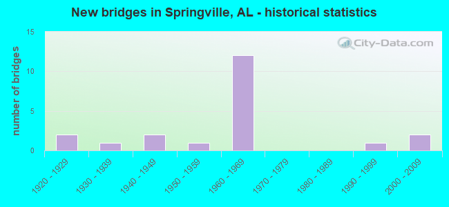
- New bridges - historical statistics
- 21920-1929
- 11930-1939
- 21940-1949
- 11950-1959
- 121960-1969
- 11990-1999
- 22000-2009

- Reconstructed bridges - Historical Statistics
- 11960-1969
- 01970-1979
- 11980-1989


- Bridge Condition - Deck
- 15.4%Very good
- 15.4%Good
- 46.2%Satisfactory
- 7.7%Fair
- 15.4%Poor

- Bridge Condition - Superstructure
- 15.4%Very good
- 23.1%Good
- 38.5%Satisfactory
- 23.1%Fair

- Bridge Condition - Substructure
- 15.4%Very good
- 23.1%Good
- 53.8%Satisfactory
- 7.7%Fair

- Bridge Condition - Channel
- 15.4%Very good
- 23.1%Good
- 53.8%Satisfactory
- 7.7%Fair
Find on map >> Show street view
Structure Number: 225, Location: .3 MI. SO. I-59 (Lat: 33.781000, Lng: -86.430900), Route carried "on" structure: US 23, Year Built: 1924, Status: Open, Structure Length: 6.46m (21.19ft), Average Daily Traffic: 6,701 (year 2021), Truck Traffic: 6%, Average Future Daily Traffic: 12,101 (year 2041), Design Load: H 15, Features Intersected: NORFOLK SOUTHERN
Minimum Vertical Clearance: 30+ m (98+ ft), Kilometerpoint: 0.014, Lanes on structure: 2, Owner: State Highway Agency, Approaching Roadway Width: 6.1m (20.0ft), Material/Design: Concrete, Design/Construction: Tee Beam, Number Of Spans In Main Unit: 5, Length of Maximum Span: 12.8m (42.0ft), Curb-To-Curb Width: 6.5m (21.3ft), Out-to-Out Width: 7.3m (24.0ft)
Condition: Deck: Fair, Superstructure: Fair, Substructure: Fair, Operating Rating: 64.0 metric tons, Method Used To Determine Operating Rating: Load Factor (LF), Inventory Rating: 38.4 metric tons, Method Used To Determine Inventory Rating: Load Factor (LF), Structural Evaluation: Somewhat better than minimum adequacy, Deck Geometry: High priority of replacement, Underclear: Meets minimum limits, Approach Roadway Alignment: Somewhat better than minimum adequacy, Length Of Structure Improvement: 7.50m (24.61ft), Designated Inspection Frequency: Every 24 months, Inspection Date: October 2021, Bridge Improvement Cost: $1,234,000, Roadway Improvement Cost: $123,000, Total Project Cost: $1,357,000 ( Estimate for 2022), Deck Structure Type: Concrete Cast-file-Place, Wearing Surface/Protective System: Wearing Surface: Bituminous
Find on map >> Show street view
Structure Number: 226, Location: 0 . 3 MI NORTH I 59 (Lat: 33.775000, Lng: -86.425000), Route carried "on" structure: US 23, Year Built: 1924, Status: Open, Structure Length: 1.86m (6.10ft), Average Daily Traffic: 3,370 (year 2021), Truck Traffic: 5%, Average Future Daily Traffic: 4,088 (year 2041), Features Intersected: BRANCH
Minimum Vertical Clearance: 30+ m (98+ ft), Kilometerpoint: 1.159, Lanes on structure: 2, Owner: State Highway Agency, Approaching Roadway Width: 6.1m (20.0ft), Material/Design: Concrete, Design/Construction: Tee Beam, Number Of Spans In Main Unit: 2, Length of Maximum Span: 9.1m (29.9ft), Curb-To-Curb Width: 5.5m (18.0ft), Out-to-Out Width: 5.7m (18.7ft)
Condition: Deck: Satisfactory, Superstructure: Satisfactory, Substructure: Satisfactory, Channel: Satisfactory, Operating Rating: 60.0 metric tons, Method Used To Determine Operating Rating: Load Factor (LF), Inventory Rating: 35.9 metric tons, Method Used To Determine Inventory Rating: Load Factor (LF), Structural Evaluation: Equal to present minimum criteria, Deck Geometry: High priority of replacement, Waterway Adequacy: Equal to present minimum criteria, Approach Roadway Alignment: Equal to present minimum criteria, Length Of Structure Improvement: 2.58m (8.46ft), Designated Inspection Frequency: Every 24 months, Inspection Date: April 2021, Bridge Improvement Cost: $318,000, Roadway Improvement Cost: $32,000, Total Project Cost: $350,000 ( Estimate for 2022), Deck Structure Type: Concrete Cast-file-Place, Wearing Surface/Protective System: Wearing Surface: Bituminous
Find on map >> Show street view
Structure Number: 3077, Location: 0.1 NW FAIRVIEW CHURCH (Lat: 33.780061, Lng: -86.362444), Route carried "on" structure: ServiceCounty highway 35, Year Built: 1947, Year Reconstructed: 1991, Status: Open, Structure Length: 2.13m (6.99ft), Average Daily Traffic: 250 (year 1999), Truck Traffic: 10%, Average Future Daily Traffic: 411 (year 2029), Design Load: HS 20, Features Intersected: CANOE CREEK
Minimum Vertical Clearance: 30+ m (98+ ft), Kilometerpoint: 0.010, Lanes on structure: 1, Owner: County Highway Agency, Approaching Roadway Width: 8.5m (27.9ft), Material/Design: Concrete, Design/Construction: Channel Beam, Number Of Spans In Main Unit: 2, Length of Maximum Span: 10.4m (34.1ft), Curb-To-Curb Width: 7.3m (24.0ft), Out-to-Out Width: 7.3m (24.0ft)
Condition: Deck: Good, Superstructure: Good, Substructure: Very good, Channel: Very good, Operating Rating: 75.2 metric tons, Method Used To Determine Operating Rating: Load Factor (LF), Inventory Rating: 45.2 metric tons, Method Used To Determine Inventory Rating: Load Factor (LF), Structural Evaluation: Better than present minimum criteria, Deck Geometry: Somewhat better than minimum adequacy, Waterway Adequacy: Better than present minimum criteria, Approach Roadway Alignment: Equal to present minimum criteria, Length Of Structure Improvement: 2.91m (9.55ft), Designated Inspection Frequency: Every 24 months, Inspection Date: January 2021, Bridge Improvement Cost: $480,000, Roadway Improvement Cost: $48,000, Total Project Cost: $528,000 ( Estimate for 2022), Deck Structure Type: Concrete Precast Panels
Find on map >> Show street view
Structure Number: 3365, Location: 4.2 MI.EA. I-59 (Lat: 33.733111, Lng: -86.410222), Route carried "on" structure: State highway 174, Year Built: 1948, Status: Open, Structure Length: 4.27m (14.01ft), Average Daily Traffic: 3,800 (year 2021), Truck Traffic: 6%, Average Future Daily Traffic: 4,979 (year 2041), Design Load: H 15, Features Intersected: LITTLE CANOE CREEK
Minimum Vertical Clearance: 30+ m (98+ ft), Kilometerpoint: 7.807, Lanes on structure: 2, Owner: State Highway Agency, Approaching Roadway Width: 7.3m (24.0ft), Skew: 4 degrees, Material/Design: Concrete, Design/Construction: Tee Beam, Number Of Spans In Main Unit: 5, Length of Maximum Span: 8.5m (27.9ft), Curb-To-Curb Width: 7.3m (24.0ft), Out-to-Out Width: 8.2m (26.9ft)
Condition: Deck: Satisfactory, Superstructure: Satisfactory, Substructure: Satisfactory, Channel: Satisfactory, Operating Rating: 50.7 metric tons, Method Used To Determine Operating Rating: Allowable Stress (AS), Inventory Rating: 31.4 metric tons, Method Used To Determine Inventory Rating: Allowable Stress (AS), Structural Evaluation: Equal to present minimum criteria, Deck Geometry: High priority of replacement, Waterway Adequacy: Equal to present minimum criteria, Approach Roadway Alignment: Equal to present desirable criteria, Length Of Structure Improvement: 5.24m (17.19ft), Designated Inspection Frequency: Every 24 months, Inspection Date: August 2021, Bridge Improvement Cost: $970,000, Roadway Improvement Cost: $97,000, Total Project Cost: $1,067,000 ( Estimate for 2022), Deck Structure Type: Concrete Cast-file-Place
Find on map >> Show street view
Structure Number: 4843, Location: 1 2 MI NW SPRINGVILLE (Lat: 33.799417, Lng: -86.488350), Route carried "on" structure: ServiceCounty highway 17, Year Built: 1954, Status: Posted for load, Structure Length: 7.68m (25.20ft), Average Daily Traffic: 1,970 (year 2017), Truck Traffic: 3%, Average Future Daily Traffic: 2,928 (year 2037), Design Load: H 15, Features Intersected: BIG CANOE CREEK
Minimum Vertical Clearance: 30+ m (98+ ft), Kilometerpoint: 0.010, Lanes on structure: 2, Owner: County Highway Agency, Approaching Roadway Width: 8.5m (27.9ft), Material/Design: Concrete, Design/Construction: Tee Beam, Number Of Spans In Main Unit: 7, Length of Maximum Span: 11.0m (36.1ft), Curb-To-Curb Width: 6.7m (22.0ft), Out-to-Out Width: 7.3m (24.0ft)
Condition: Deck: Satisfactory, Superstructure: Good, Substructure: Good, Channel: Good, Operating Rating: 33.7 metric tons, Method Used To Determine Operating Rating: Allowable Stress (AS), Inventory Rating: 21.0 metric tons, Method Used To Determine Inventory Rating: Allowable Stress (AS), Structural Evaluation: Somewhat better than minimum adequacy, Deck Geometry: High priority of corrective action, Waterway Adequacy: Better than present minimum criteria, Approach Roadway Alignment: Equal to present desirable criteria, Bridge Posting: Required (Relationship of Operating Rating to Maximum Legal Load: 0.1 - 9.9% below), Length Of Structure Improvement: 8.70m (28.54ft), Designated Inspection Frequency: Every 24 months, Other Special Inspection Frequency: Every 12 months, Inspection Date: Febuary 2021, Other Special Inspection Date: Febuary 2022, Bridge Improvement Cost: $1,431,000, Roadway Improvement Cost: $143,000, Total Project Cost: $1,574,000 ( Estimate for 2022), Deck Structure Type: Concrete Cast-file-Place
Find on map >> Show street view
Structure Number: 7226, Location: I59 * MOUNTAIN VIEW RD (Lat: 33.745697, Lng: -86.485889), Route carried "on" structure: County highway , Year Built: 1961, Status: Open, Structure Length: 8.72m (28.61ft), Average Daily Traffic: 895 (year 2021), Truck Traffic: 1%, Average Future Daily Traffic: 1,315 (year 2041), Design Load: HS 20, Features Intersected: I - 59, Facility Carried by Structure: MOUNTAIN VIEW RD
Minimum Vertical Clearance: 30+ m (98+ ft), Kilometerpoint: 0.010, Lanes on structure: 2, Lanes under structure: 4, Owner: State Highway Agency, Approaching Roadway Width: 9.1m (29.9ft), Skew: 1 degrees, Material/Design: Steel, Design/Construction: Stringer/Multi-beam, Number Of Spans In Main Unit: 4, Length of Maximum Span: 21.6m (70.9ft), Curb-To-Curb Width: 7.3m (24.0ft), Out-to-Out Width: 8.2m (26.9ft)
Condition: Deck: Satisfactory, Superstructure: Satisfactory, Substructure: Satisfactory, Operating Rating: 50.3 metric tons, Method Used To Determine Operating Rating: Load Factor (LF), Inventory Rating: 30.1 metric tons, Method Used To Determine Inventory Rating: Load Factor (LF), Structural Evaluation: Equal to present minimum criteria, Deck Geometry: Meets minimum limits, Underclear: Equal to present minimum criteria, Approach Roadway Alignment: Somewhat better than minimum adequacy, Length Of Structure Improvement: 9.70m (31.82ft), Designated Inspection Frequency: Every 24 months, Inspection Date: December 2021, Bridge Improvement Cost: $1,796,000, Roadway Improvement Cost: $180,000, Total Project Cost: $1,976,000 ( Estimate for 2022), Deck Structure Type: Concrete Cast-file-Place
Find on map >> Show street view
Structure Number: 7227, Location: 2.1 MI SO JCT AL 174 (Lat: 33.756056, Lng: -86.479139), Route carried "on" structure: Interstate 59, Year Built: 1961, Status: Open, Structure Length: 2.74m (8.99ft), Average Daily Traffic: 13,255 (year 2021), Truck Traffic: 26%, Average Future Daily Traffic: 16,399 (year 2041), Design Load: HS 20, Features Intersected: BRANCH
Minimum Vertical Clearance: 7.56m (24.80ft), Kilometerpoint: 245.935, Lanes on structure: 2, Base Highway Network: Yes, Owner: State Highway Agency, Approaching Roadway Width: 12.2m (40.0ft), Skew: 4 degrees, Material/Design: Concrete, Design/Construction: Culvert, Number Of Spans In Main Unit: 5, Length of Maximum Span: 3.7m (12.1ft)
Condition: Channel: Satisfactory, Culverts: Satisfactory, Operating Rating: 34.2 metric tons, Method Used To Determine Operating Rating: Load Factor (LF), Inventory Rating: 20.7 metric tons, Method Used To Determine Inventory Rating: Load Factor (LF), Structural Evaluation: Somewhat better than minimum adequacy, Waterway Adequacy: Somewhat better than minimum adequacy, Approach Roadway Alignment: Equal to present desirable criteria, Length Of Structure Improvement: 3.66m (12.01ft), Designated Inspection Frequency: Every 24 months, Inspection Date: September 2021, Bridge Improvement Cost: $2,391,000, Roadway Improvement Cost: $239,000, Total Project Cost: $2,630,000 ( Estimate for 2022), Wearing Surface/Protective System: Wearing Surface: Bituminous
Find on map >> Show street view
Structure Number: 723, Location: .2 MI SO JCT AL 23 (Lat: 33.776389, Lng: -86.429722), Route carried "on" structure: Interstate 59, Year Built: 1961, Status: Open, Structure Length: 0.84m (2.76ft), Average Daily Traffic: 26,310 (year 2021), Truck Traffic: 27%, Average Future Daily Traffic: 32,551 (year 2041), Design Load: HS 20, Features Intersected: LEFT HAND PRONG
Minimum Vertical Clearance: 30+ m (98+ ft), Kilometerpoint: 251.100, Lanes on structure: 6, Base Highway Network: Yes, Owner: State Highway Agency, Approaching Roadway Width: 37.2m (122.0ft), Skew: 2 degrees, Material/Design: Concrete, Design/Construction: Culvert, Number Of Spans In Main Unit: 2, Length of Maximum Span: 3.7m (12.1ft)
Condition: Channel: Satisfactory, Culverts: Satisfactory, Operating Rating: 88.9 metric tons, Method Used To Determine Operating Rating: Load Factor (LF), Inventory Rating: 88.9 metric tons, Method Used To Determine Inventory Rating: Load Factor (LF), Structural Evaluation: Equal to present minimum criteria, Waterway Adequacy: Better than present minimum criteria, Approach Roadway Alignment: Equal to present desirable criteria, Length Of Structure Improvement: 1.50m (4.92ft), Designated Inspection Frequency: Every 24 months, Inspection Date: September 2021, Bridge Improvement Cost: $2,310,000, Roadway Improvement Cost: $231,000, Total Project Cost: $2,541,000 ( Estimate for 2022), Wearing Surface/Protective System: Wearing Surface: Bituminous
Find on map >> Show street view
Structure Number: 7231, Location: I59 * CANOE CREEK (Lat: 33.800800, Lng: -86.372400), Route carried "on" structure: Interstate 59, Year Built: 1961, Status: Open, Structure Length: 14.76m (48.43ft), Average Daily Traffic: 10,585 (year 2022), Truck Traffic: 27%, Average Future Daily Traffic: 13,096 (year 2042), Design Load: HS 20, Features Intersected: CANOE CREEK
Minimum Vertical Clearance: 30+ m (98+ ft), Kilometerpoint: 257.176, Lanes on structure: 2, Base Highway Network: Yes, Owner: State Highway Agency, Approaching Roadway Width: 12.2m (40.0ft), Material/Design: Concrete continuous, Design/Construction: Tee Beam, Number Of Spans In Main Unit: 3, Number Of Approach Spans: 10, Length of Maximum Span: 16.8m (55.1ft), Curb-To-Curb Width: 8.5m (27.9ft), Out-to-Out Width: 9.4m (30.8ft)
Condition: Deck: Poor, Superstructure: Fair, Substructure: Satisfactory, Channel: Satisfactory, Operating Rating: 48.4 metric tons, Method Used To Determine Operating Rating: Load Factor (LF), Inventory Rating: 29.0 metric tons, Method Used To Determine Inventory Rating: Load Factor (LF), Structural Evaluation: Somewhat better than minimum adequacy, Deck Geometry: High priority of corrective action, Waterway Adequacy: Equal to present minimum criteria, Approach Roadway Alignment: Better than present minimum criteria, Length Of Structure Improvement: 15.54m (50.98ft), Designated Inspection Frequency: Every 24 months, Other Special Inspection Frequency: Every 12 months, Inspection Date: March 2022, Other Special Inspection Date: March 2022, Bridge Improvement Cost: $3,304,000, Roadway Improvement Cost: $330,000, Total Project Cost: $3,634,000 ( Estimate for 2022), Deck Structure Type: Concrete Cast-file-Place
Find on map >> Show street view
Structure Number: 7232, Location: I59 * CANOE CREEK (Lat: 33.800200, Lng: -86.372000), Route carried "on" structure: Interstate 59, Year Built: 1961, Status: Temporarily open, Structure Length: 14.75m (48.39ft), Average Daily Traffic: 10,585 (year 2022), Truck Traffic: 27%, Average Future Daily Traffic: 13,096 (year 2042), Design Load: HS 20, Features Intersected: CANOE CREEK
Minimum Vertical Clearance: 30+ m (98+ ft), Kilometerpoint: 257.176, Lanes on structure: 2, Base Highway Network: Yes, Owner: State Highway Agency, Approaching Roadway Width: 12.2m (40.0ft), Material/Design: Concrete continuous, Design/Construction: Tee Beam, Number Of Spans In Main Unit: 3, Number Of Approach Spans: 10, Length of Maximum Span: 16.8m (55.1ft), Curb-To-Curb Width: 8.5m (27.9ft), Out-to-Out Width: 9.4m (30.8ft)
Condition: Deck: Poor, Superstructure: Fair, Substructure: Satisfactory, Channel: Fair, Operating Rating: 48.4 metric tons, Method Used To Determine Operating Rating: Load Factor (LF), Inventory Rating: 29.0 metric tons, Method Used To Determine Inventory Rating: Load Factor (LF), Structural Evaluation: Somewhat better than minimum adequacy, Deck Geometry: High priority of corrective action, Waterway Adequacy: Equal to present minimum criteria, Approach Roadway Alignment: Better than present minimum criteria, Length Of Structure Improvement: 15.53m (50.95ft), Designated Inspection Frequency: Every 24 months, Other Special Inspection Frequency: Every 12 months, Inspection Date: March 2022, Other Special Inspection Date: March 2022, Bridge Improvement Cost: $3,194,000, Roadway Improvement Cost: $319,000, Total Project Cost: $3,513,000 ( Estimate for 2022), Deck Structure Type: Concrete Cast-file-Place
Find on map >> Show street view
Structure Number: 7375, Location: AL 23 * I 59 (Lat: 33.777778, Lng: -86.427778), Route carried "on" structure: State highway 23, Year Built: 1961, Status: Open, Structure Length: 9.43m (30.94ft), Average Daily Traffic: 2,880 (year 2021), Truck Traffic: 5%, Average Future Daily Traffic: 3,493 (year 2041), Design Load: HS 20, Features Intersected: I 59
Minimum Vertical Clearance: 30+ m (98+ ft), Kilometerpoint: 0.644, Lanes on structure: 2, Lanes under structure: 4, Owner: State Highway Agency, Approaching Roadway Width: 8.5m (27.9ft), Skew: 3 degrees, Material/Design: Concrete continuous, Design/Construction: Tee Beam, Number Of Spans In Main Unit: 4, Length of Maximum Span: 25.9m (85.0ft), Curb-To-Curb Width: 8.5m (27.9ft), Out-to-Out Width: 9.8m (32.2ft)
Condition: Deck: Satisfactory, Superstructure: Satisfactory, Substructure: Satisfactory, Operating Rating: 48.0 metric tons, Method Used To Determine Operating Rating: Load Factor (LF), Inventory Rating: 27.2 metric tons, Method Used To Determine Inventory Rating: Load Factor (LF), Structural Evaluation: Equal to present minimum criteria, Deck Geometry: Meets minimum limits, Underclear: Equal to present minimum criteria, Approach Roadway Alignment: Equal to present desirable criteria, Length Of Structure Improvement: 10.39m (34.09ft), Designated Inspection Frequency: Every 24 months, Inspection Date: September 2021, Bridge Improvement Cost: $2,279,000, Roadway Improvement Cost: $228,000, Total Project Cost: $2,507,000 ( Estimate for 2022), Deck Structure Type: Concrete Cast-file-Place
Find on map >> Show street view
Structure Number: 7496, Location: I59 * AL 174 (Lat: 33.768889, Lng: -86.466111), Route carried "on" structure: State highway 174, Year Built: 1961, Status: Open, Structure Length: 10.67m (35.01ft), Average Daily Traffic: 6,960 (year 2021), Truck Traffic: 6%, Average Future Daily Traffic: 9,119 (year 2041), Design Load: HS 20, Features Intersected: I - 59
Minimum Vertical Clearance: 30+ m (98+ ft), Kilometerpoint: 0.982, Lanes on structure: 2, Lanes under structure: 4, Owner: State Highway Agency, Approaching Roadway Width: 10.4m (34.1ft), Skew: 4 degrees, Material/Design: Concrete continuous, Design/Construction: Tee Beam, Number Of Spans In Main Unit: 4, Length of Maximum Span: 106.7m (350.1ft), Curb-To-Curb Width: 8.5m (27.9ft), Out-to-Out Width: 9.4m (30.8ft)
Condition: Deck: Satisfactory, Superstructure: Satisfactory, Substructure: Satisfactory, Operating Rating: 42.1 metric tons, Method Used To Determine Operating Rating: Load Factor (LF), Inventory Rating: 26.0 metric tons, Method Used To Determine Inventory Rating: Load Factor (LF), Structural Evaluation: Equal to present minimum criteria, Deck Geometry: Meets minimum limits, Underclear: Equal to present minimum criteria, Approach Roadway Alignment: Equal to present desirable criteria, Length Of Structure Improvement: 11.57m (37.96ft), Designated Inspection Frequency: Every 24 months, Inspection Date: September 2021, Bridge Improvement Cost: $2,460,000, Roadway Improvement Cost: $246,000, Total Project Cost: $2,706,000 ( Estimate for 2022), Deck Structure Type: Concrete Cast-file-Place
Find on map >> Show street view
Structure Number: 8364, Location: 1 5 MI SW SPRINGVILLE (Lat: 33.752689, Lng: -86.486139), Route carried "on" structure: ServiceCounty highway 510, Year Built: 1964, Status: Open, Structure Length: 1.13m (3.71ft), Average Daily Traffic: 2,310 (year 2017), Truck Traffic: 2%, Average Future Daily Traffic: 2,815 (year 2037), Design Load: H 15, Features Intersected: NO NAME, Facility Carried by Structure: ST CLAIR CO HWY 5
Minimum Vertical Clearance: 30+ m (98+ ft), Kilometerpoint: 0.010, Lanes on structure: 2, Owner: County Highway Agency, Approaching Roadway Width: 9.1m (29.9ft), Material/Design: Concrete, Design/Construction: Culvert, Number Of Spans In Main Unit: 3, Length of Maximum Span: 4.0m (13.1ft), Curb-To-Curb Width: 8.0m (26.2ft), Out-to-Out Width: 8.5m (27.9ft)
Condition: Channel: Satisfactory, Culverts: Satisfactory, Operating Rating: 66.1 metric tons, Method Used To Determine Operating Rating: Load Factor (LF), Inventory Rating: 39.6 metric tons, Method Used To Determine Inventory Rating: Load Factor (LF), Structural Evaluation: Equal to present minimum criteria, Deck Geometry: High priority of corrective action, Waterway Adequacy: Better than present minimum criteria, Approach Roadway Alignment: Equal to present minimum criteria, Length Of Structure Improvement: 1.81m (5.94ft), Designated Inspection Frequency: Every 24 months, Inspection Date: January 2021, Bridge Improvement Cost: $281,000, Roadway Improvement Cost: $28,000, Total Project Cost: $309,000 ( Estimate for 2022), Deck Structure Type: Concrete Cast-file-Place, Wearing Surface/Protective System: Wearing Surface: Bituminous
Find on map >> Show street view
Structure Number: 9491, Location: JCT CO RD 30 (Lat: 33.748333, Lng: -86.493333), Route carried "on" structure: US 11, Year Built: 1934, Year Reconstructed: 1968, Status: Open, Structure Length: 1.01m (3.31ft), Average Daily Traffic: 5,130 (year 2020), Truck Traffic: 4%, Average Future Daily Traffic: 6,721 (year 2040), Design Load: H 15, Features Intersected: BRANCH
Minimum Vertical Clearance: 30.18m (99.02ft), Kilometerpoint: 258.411, Lanes on structure: 2, Owner: State Highway Agency, Approaching Roadway Width: 7.3m (24.0ft), Material/Design: Concrete, Design/Construction: Culvert, Number Of Spans In Main Unit: 3, Length of Maximum Span: 3.0m (9.8ft)
Condition: Channel: Satisfactory, Culverts: Satisfactory, Operating Rating: 78.1 metric tons, Method Used To Determine Operating Rating: Load Factor (LF), Inventory Rating: 46.9 metric tons, Method Used To Determine Inventory Rating: Load Factor (LF), Structural Evaluation: Equal to present minimum criteria, Waterway Adequacy: Equal to present desirable criteria, Approach Roadway Alignment: Equal to present desirable criteria, Length Of Structure Improvement: 1.68m (5.51ft), Designated Inspection Frequency: Every 24 months, Inspection Date: November 2020, Bridge Improvement Cost: $524,000, Roadway Improvement Cost: $52,000, Total Project Cost: $576,000 ( Estimate for 2022), Wearing Surface/Protective System: Wearing Surface: Bituminous
Find on map >> Show street view
Structure Number: 15183, Location: 4 3 MI NE SPRINGVILLE (Lat: 33.804406, Lng: -86.419556), Route carried "on" structure: ServiceCounty highway 40, Year Built: 1990, Status: Open, Structure Length: 4.15m (13.62ft), Average Daily Traffic: 368 (year 2017), Truck Traffic: 1%, Average Future Daily Traffic: 547 (year 2037), Design Load: HS 20, Features Intersected: CANOE CREEK
Minimum Vertical Clearance: 30+ m (98+ ft), Kilometerpoint: 0.010, Lanes on structure: 2, Owner: County Highway Agency, Approaching Roadway Width: 8.5m (27.9ft), Material/Design: Concrete, Design/Construction: Channel Beam, Number Of Spans In Main Unit: 4, Length of Maximum Span: 10.4m (34.1ft), Curb-To-Curb Width: 7.3m (24.0ft), Out-to-Out Width: 7.3m (24.0ft)
Condition: Deck: Good, Superstructure: Good, Substructure: Good, Channel: Good, Operating Rating: 75.6 metric tons, Method Used To Determine Operating Rating: Load Factor (LF), Inventory Rating: 45.4 metric tons, Method Used To Determine Inventory Rating: Load Factor (LF), Structural Evaluation: Better than present minimum criteria, Deck Geometry: Somewhat better than minimum adequacy, Waterway Adequacy: Better than present minimum criteria, Approach Roadway Alignment: Equal to present minimum criteria, Length Of Structure Improvement: 5.12m (16.80ft), Designated Inspection Frequency: Every 24 months, Inspection Date: January 2021, Bridge Improvement Cost: $842,000, Roadway Improvement Cost: $84,000, Total Project Cost: $926,000 ( Estimate for 2022), Deck Structure Type: Concrete Precast Panels
Find on map >> Show street view
Structure Number: 17943, Location: 3.5 MI. NO. AL 23 (Lat: 33.814003, Lng: -86.382353), Route carried "on" structure: US 11, Year Built: 2005, Status: Open, Structure Length: 7.32m (24.02ft), Average Daily Traffic: 3,070 (year 2021), Truck Traffic: 5%, Average Future Daily Traffic: 4,022 (year 2041), Design Load: HS 20, Features Intersected: BIG CANOE CREEK
Minimum Vertical Clearance: 30+ m (98+ ft), Kilometerpoint: 273.378, Lanes on structure: 2, Owner: State Highway Agency, Approaching Roadway Width: 13.4m (44.0ft), Material/Design: Prestressed concrete, Design/Construction: Stringer/Multi-beam, Number Of Spans In Main Unit: 2, Number Of Approach Spans: 1, Length of Maximum Span: 30.5m (100.1ft), Curb-To-Curb Width: 13.4m (44.0ft), Out-to-Out Width: 14.3m (46.9ft)
Condition: Deck: Very good, Superstructure: Very good, Substructure: Good, Channel: Good, Operating Rating: 60.0 metric tons, Method Used To Determine Operating Rating: Load Factor (LF), Inventory Rating: 37.6 metric tons, Method Used To Determine Inventory Rating: Load Factor (LF), Structural Evaluation: Better than present minimum criteria, Deck Geometry: Better than present minimum criteria, Waterway Adequacy: Superior to present desirable criteria, Approach Roadway Alignment: Superior to present desirable criteria, Length Of Structure Improvement: 8.34m (27.36ft), Designated Inspection Frequency: Every 24 months, Inspection Date: September 2021, Bridge Improvement Cost: $2,631,000, Roadway Improvement Cost: $263,000, Total Project Cost: $2,894,000 ( Estimate for 2022), Deck Structure Type: Concrete Cast-file-Place
Find on map >> Show street view
Structure Number: 19206, Location: 4.4 MI NW SPRINGVILLE (Lat: 33.793533, Lng: -86.517219), Route carried "on" structure: ServiceCounty highway 43, Year Built: 2005, Status: Open, Structure Length: 4.88m (16.01ft), Average Daily Traffic: 14 (year 2004), Average Future Daily Traffic: 28 (year 2029), Design Load: HS 20, Features Intersected: BIG CANOE CREEK, Facility Carried by Structure: CANOE CREEK ROAD
Minimum Vertical Clearance: 30+ m (98+ ft), Kilometerpoint: 0.000, Lanes on structure: 2, Owner: County Highway Agency, Approaching Roadway Width: 8.5m (27.9ft), Skew: 3 degrees, Material/Design: Concrete, Design/Construction: Channel Beam, Number Of Spans In Main Unit: 4, Length of Maximum Span: 12.2m (40.0ft), Curb-To-Curb Width: 8.5m (27.9ft), Out-to-Out Width: 9.1m (29.9ft)
Condition: Deck: Very good, Superstructure: Very good, Substructure: Very good, Channel: Very good, Operating Rating: 88.9 metric tons, Method Used To Determine Operating Rating: Load Factor (LF), Inventory Rating: 55.1 metric tons, Method Used To Determine Inventory Rating: Load Factor (LF), Structural Evaluation: Equal to present desirable criteria, Deck Geometry: Better than present minimum criteria, Waterway Adequacy: Equal to present minimum criteria, Approach Roadway Alignment: Better than present minimum criteria, Length Of Structure Improvement: 5.89m (19.32ft), Designated Inspection Frequency: Every 24 months, Inspection Date: January 2021, Bridge Improvement Cost: $1,211,000, Roadway Improvement Cost: $121,000, Total Project Cost: $1,332,000 ( Estimate for 2022), Deck Structure Type: Concrete Precast Panels, Wearing Surface/Protective System: Wearing Surface: Other
Find on map >> Show street view
Structure Number: 7226, Location: I59 * MOUNTAIN VIEW RD (Lat: 33.745697, Lng: -86.485889), Route carried "under" structure: Interstate 59, Year Built: 1961, Structure Length: 0. m, Average Daily Traffic: 26,510 (year 2021), Truck Traffic: 26%, Features Intersected: I - 59, Facility Carried by Structure: MOUNTAIN VIEW RD
Minimum Vertical Clearance: 5.11m (16.77ft), Kilometerpoint: 244.426, Lanes on structure: 2, Lanes under structure: 4, Material/Design: Steel, Design/Construction: Stringer/Multi-beam, Length of Maximum Span: 21.6m (70.9ft)
Find on map >> Show street view
Structure Number: 7233, Location: CO RD 31 * I59 (Lat: 33.809447, Lng: -86.359108), Route carried "under" structure: Interstate 59, Year Built: 1961, Structure Length: 0. m, Average Daily Traffic: 21,594 (year 2020), Truck Traffic: 27%, Features Intersected: I59, Facility Carried by Structure: CO RD 31
Minimum Vertical Clearance: 4.94m (16.21ft), Kilometerpoint: 258.733, Lanes on structure: 2, Lanes under structure: 6, Material/Design: Concrete continuous, Design/Construction: Tee Beam, Length of Maximum Span: 22.3m (73.2ft)
Find on map >> Show street view
Structure Number: 7375, Location: AL 23 * I 59 (Lat: 33.777778, Lng: -86.427778), Route carried "under" structure: Interstate 59, Year Built: 1961, Structure Length: 0. m, Average Daily Traffic: 26,310 (year 2021), Truck Traffic: 27%, Features Intersected: I 59, Facility Carried by Structure: AL 23
Minimum Vertical Clearance: 5.26m (17.26ft), Kilometerpoint: 251.380, Lanes on structure: 2, Lanes under structure: 4, Material/Design: Concrete continuous, Design/Construction: Tee Beam, Length of Maximum Span: 25.9m (85.0ft)
Find on map >> Show street view
Structure Number: 7496, Location: I59 * AL 174 (Lat: 33.768889, Lng: -86.466111), Route carried "under" structure: Interstate 59, Year Built: 1961, Structure Length: 0. m, Average Daily Traffic: 26,310 (year 2021), Truck Traffic: 27%, Features Intersected: I - 59, Facility Carried by Structure: AL - 174
Minimum Vertical Clearance: 5.26m (17.26ft), Kilometerpoint: 247.754, Lanes on structure: 2, Lanes under structure: 4, Material/Design: Concrete continuous, Design/Construction: Tee Beam, Length of Maximum Span: 106.7m (350.1ft)