Bridge Statistics for St. Albans, Vermont (VT)
Condition, Traffic, Stress, Structural Evaluation, Project Costs
- National Bridge Inventory (NBI) Statistics
- 20Number of bridges
- 197ft / 60.1mTotal length
- $9,841,000Total costs
- 175,365Total average daily traffic
- 18,163Total average daily truck traffic
- National Bridge Inventory (NBI) Registered Bridges for St. Albans
- No street view available for this location
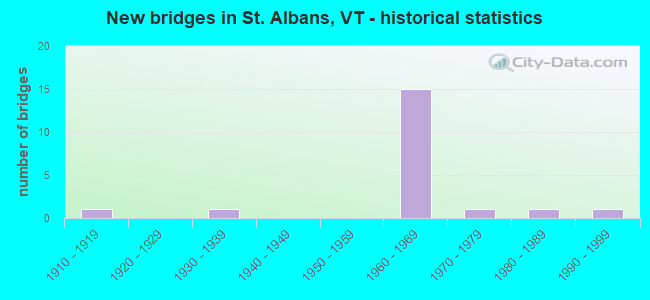
- New bridges - historical statistics
- 11910-1919
- 11930-1939
- 151960-1969
- 11970-1979
- 11980-1989
- 11990-1999
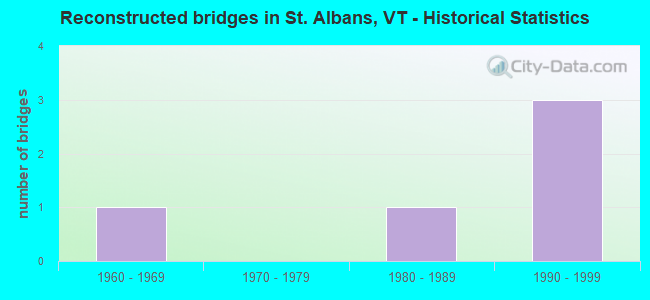
- Reconstructed bridges - Historical Statistics
- 11960-1969
- 01970-1979
- 11980-1989
- 31990-1999
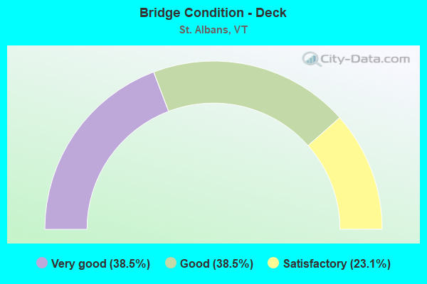
- Bridge Condition - Deck
- 38.5%Very good
- 38.5%Good
- 23.1%Satisfactory
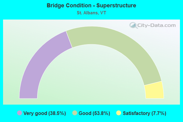
- Bridge Condition - Superstructure
- 38.5%Very good
- 53.8%Good
- 7.7%Satisfactory
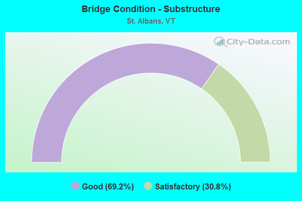
- Bridge Condition - Substructure
- 69.2%Good
- 30.8%Satisfactory
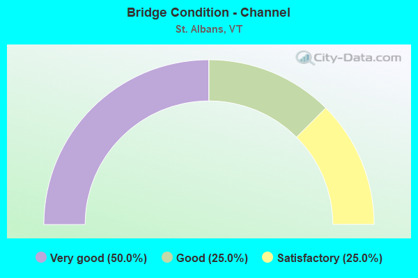
- Bridge Condition - Channel
- 50.0%Very good
- 25.0%Good
- 25.0%Satisfactory
Find on map >> Show street view
Structure Number: 100612001006121, Location: 0.2 MI TO JCT TH154/NASON (Lat: 44.805583, Lng: -73.089328), Route carried "on" structure: City street C30LE, Year Built: 1985, Status: Open, Structure Length: 0.73m (2.40ft), Average Daily Traffic: 100 (year 2019), Truck Traffic: 2%, Average Future Daily Traffic: 105 (year 2029), Features Intersected: STEVENS BROOK
Minimum Vertical Clearance: 30+ m (98+ ft), Kilometerpoint: 0.000, Lanes on structure: 2, Owner: City or Municipal Highway Agency, Approaching Roadway Width: 7.3m (24.0ft), Material/Design: Concrete, Design/Construction: Tee Beam, Number Of Spans In Main Unit: 1, Length of Maximum Span: 6.7m (22.0ft), Curb-To-Curb Width: 7.3m (24.0ft), Out-to-Out Width: 7.3m (24.0ft)
Condition: Deck: Good, Superstructure: Good, Substructure: Good, Channel: Very good, Operating Rating: 54.4 metric tons, Method Used To Determine Operating Rating: Field evaluation and documented engineering judgment, Inventory Rating: 32.7 metric tons, Method Used To Determine Inventory Rating: Field evaluation and documented engineering judgment, Structural Evaluation: Better than present minimum criteria, Deck Geometry: Equal to present minimum criteria, Waterway Adequacy: Equal to present minimum criteria, Approach Roadway Alignment: Equal to present desirable criteria, Designated Inspection Frequency: Every 24 months, Inspection Date: September 2021, Deck Structure Type: Concrete Precast Panels, Wearing Surface/Protective System: Wearing Surface: Bituminous, Membrane: Other
Find on map >> Show street view
Structure Number: 100613000206131, Location: 0.03 MI TO JCT W CL2 TH3 (Lat: 44.810558, Lng: -73.151789), Route carried "on" structure: Other road C2002, Year Built: 1994, Status: Open, Structure Length: 3.11m (10.20ft), Average Daily Traffic: 3,690 (year 2019), Truck Traffic: 3%, Average Future Daily Traffic: 3,875 (year 2029), Design Load: HS 25 or greater, Features Intersected: JEWETT BROOK
Minimum Vertical Clearance: 30+ m (98+ ft), Kilometerpoint: 0.000, Lanes on structure: 2, Owner: Town or Township Highway Agency, Approaching Roadway Width: 10.4m (34.1ft), Material/Design: Steel, Design/Construction: Stringer/Multi-beam, Number Of Spans In Main Unit: 1, Length of Maximum Span: 29.9m (98.1ft), Curb or Sidewalk Widths: Left: 0.1m (0.3ft), Right: 0.1m (0.3ft), Curb-To-Curb Width: 10.2m (33.5ft), Out-to-Out Width: 11.6m (38.1ft)
Condition: Deck: Very good, Superstructure: Very good, Substructure: Good, Channel: Very good, Operating Rating: 84.4 metric tons, Method Used To Determine Operating Rating: Allowable Stress (AS), Inventory Rating: 43.5 metric tons, Method Used To Determine Inventory Rating: Allowable Stress (AS), Structural Evaluation: Better than present minimum criteria, Deck Geometry: Meets minimum limits, Waterway Adequacy: Better than present minimum criteria, Approach Roadway Alignment: Equal to present desirable criteria, Designated Inspection Frequency: Every 24 months, Inspection Date: September 2021, Deck Structure Type: Concrete Cast-file-Place, Wearing Surface/Protective System: Wearing Surface: Bituminous, Membrane: Preformed Fabric, Deck Protection: Epoxy Coated Reinforcing
Find on map >> Show street view
Structure Number: 100613000906131, Location: 1.3 MI TO JCT W CL2 TH6 (Lat: 44.836247, Lng: -73.149489), Route carried "on" structure: Other road C3020, Year Built: 1919, Year Reconstructed: 1991, Status: Open, Structure Length: 0.76m (2.49ft), Average Daily Traffic: 575 (year 2019), Truck Traffic: 2%, Average Future Daily Traffic: 604 (year 2029), Design Load: HS 20, Features Intersected: JEWETT BROOK
Minimum Vertical Clearance: 30+ m (98+ ft), Kilometerpoint: 0.000, Lanes on structure: 2, Owner: Town or Township Highway Agency, Approaching Roadway Width: 6.7m (22.0ft), Skew: 2 degrees, Material/Design: Concrete, Design/Construction: Slab, Number Of Spans In Main Unit: 1, Length of Maximum Span: 7.0m (23.0ft), Curb or Sidewalk Widths: Left: 0.2m (0.7ft), Right: 0.2m (0.7ft), Curb-To-Curb Width: 7.0m (23.0ft), Out-to-Out Width: 7.7m (25.3ft)
Condition: Deck: Very good, Superstructure: Very good, Substructure: Good, Channel: Satisfactory, Operating Rating: 60.8 metric tons, Method Used To Determine Operating Rating: Allowable Stress (AS), Inventory Rating: 34.5 metric tons, Method Used To Determine Inventory Rating: Allowable Stress (AS), Structural Evaluation: Better than present minimum criteria, Deck Geometry: Meets minimum limits, Waterway Adequacy: Better than present minimum criteria, Approach Roadway Alignment: Somewhat better than minimum adequacy, Designated Inspection Frequency: Every 24 months, Inspection Date: September 2021, Deck Structure Type: Concrete Cast-file-Place, Wearing Surface/Protective System: Wearing Surface: Bituminous, Membrane: Preformed Fabric
Find on map >> Show street view
Structure Number: 100613001706131, Location: 0.07 MI TO JCT W C3 TH37 (Lat: 44.803456, Lng: -73.099286), Route carried "on" structure: Other road C3069, Year Built: 1975, Year Reconstructed: 1997, Status: Open, Structure Length: 0.88m (2.89ft), Average Daily Traffic: 600 (year 2019), Truck Traffic: 2%, Average Future Daily Traffic: 630 (year 2029), Design Load: HS 25 or greater, Features Intersected: RUGG BROOK
Minimum Vertical Clearance: 30+ m (98+ ft), Kilometerpoint: 0.000, Lanes on structure: 2, Owner: Town or Township Highway Agency, Approaching Roadway Width: 5.8m (19.0ft), Material/Design: Concrete, Design/Construction: Slab, Number Of Spans In Main Unit: 1, Length of Maximum Span: 8.2m (26.9ft), Curb-To-Curb Width: 8.2m (26.9ft), Out-to-Out Width: 8.5m (27.9ft)
Condition: Deck: Very good, Superstructure: Very good, Substructure: Good, Channel: Good, Operating Rating: 89.8 metric tons, Method Used To Determine Operating Rating: Load Factor (LF), Inventory Rating: 89.8 metric tons, Method Used To Determine Inventory Rating: Load Factor (LF), Structural Evaluation: Better than present minimum criteria, Deck Geometry: Somewhat better than minimum adequacy, Waterway Adequacy: Equal to present minimum criteria, Approach Roadway Alignment: Equal to present desirable criteria, Designated Inspection Frequency: Every 24 months, Inspection Date: September 2021, Deck Structure Type: Concrete Cast-file-Place, Wearing Surface/Protective System: Wearing Surface: Bituminous
Find on map >> Show street view
Structure Number: 200089088N06132, Location: I 89 EXIT 19 (Lat: 44.794925, Lng: -73.069453), Route carried "on" structure: Interstate 89, Year Built: 1967, Year Reconstructed: 2002, Status: Open, Structure Length: 5.15m (16.90ft), Average Daily Traffic: 22,000 (year 2018), Truck Traffic: 13%, Average Future Daily Traffic: 23,100 (year 2028), Design Load: HS 25 or greater, Features Intersected: I 89 OVER ST A SH S
Minimum Vertical Clearance: 30+ m (98+ ft), Kilometerpoint: 183.024, Lanes on structure: 3, Lanes under structure: 2, Base Highway Network: Yes, Owner: State Highway Agency, Approaching Roadway Width: 13.4m (44.0ft), Skew: 10 degrees, Material/Design: Steel continuous, Design/Construction: Stringer/Multi-beam, Number Of Spans In Main Unit: 3, Length of Maximum Span: 21.0m (68.9ft), Curb or Sidewalk Widths: Left: 0.2m (0.7ft), Right: 0.2m (0.7ft), Curb-To-Curb Width: 13.3m (43.6ft), Out-to-Out Width: 14.4m (47.2ft)
Condition: Deck: Very good, Superstructure: Very good, Substructure: Good, Operating Rating: 80.7 metric tons, Method Used To Determine Operating Rating: Load Factor (LF), Inventory Rating: 48.1 metric tons, Method Used To Determine Inventory Rating: Load Factor (LF), Structural Evaluation: Better than present minimum criteria, Deck Geometry: High priority of replacement, Underclear: Equal to present minimum criteria, Approach Roadway Alignment: Equal to present desirable criteria, Length Of Structure Improvement: 5.15m (16.90ft), Designated Inspection Frequency: Every 24 months, Inspection Date: June 2020, Bridge Improvement Cost: $2,798,000, Roadway Improvement Cost: $50,000, Total Project Cost: $2,848,000 ( Estimate for 2020), Deck Structure Type: Concrete Cast-file-Place, Wearing Surface/Protective System: Wearing Surface: Bituminous, Membrane: Preformed Fabric, Deck Protection: Epoxy Coated Reinforcing
Find on map >> Show street view
Structure Number: 200089088S06132, Location: I 89 EXIT 19 (Lat: 44.795011, Lng: -73.069725), Route carried "on" structure: Interstate 89, Year Built: 1967, Year Reconstructed: 2002, Status: Open, Structure Length: 5.61m (18.41ft), Average Daily Traffic: 22,000 (year 2018), Truck Traffic: 13%, Average Future Daily Traffic: 23,100 (year 2028), Design Load: HS 25 or greater, Features Intersected: I 89 OVER ST A SH S
Minimum Vertical Clearance: 30+ m (98+ ft), Kilometerpoint: 183.024, Lanes on structure: 2, Lanes under structure: 2, Base Highway Network: Yes, Owner: State Highway Agency, Approaching Roadway Width: 12.2m (40.0ft), Skew: 10 degrees, Material/Design: Steel continuous, Design/Construction: Stringer/Multi-beam, Number Of Spans In Main Unit: 3, Length of Maximum Span: 22.6m (74.1ft), Curb or Sidewalk Widths: Left: 0.2m (0.7ft), Right: 0.2m (0.7ft), Curb-To-Curb Width: 11.6m (38.1ft), Out-to-Out Width: 12.7m (41.7ft)
Condition: Deck: Very good, Superstructure: Very good, Substructure: Good, Operating Rating: 60.8 metric tons, Method Used To Determine Operating Rating: Load Factor (LF), Inventory Rating: 36.3 metric tons, Method Used To Determine Inventory Rating: Load Factor (LF), Structural Evaluation: Better than present minimum criteria, Deck Geometry: Equal to present minimum criteria, Underclear: Equal to present minimum criteria, Approach Roadway Alignment: Equal to present desirable criteria, Designated Inspection Frequency: Every 24 months, Inspection Date: June 2020, Deck Structure Type: Concrete Cast-file-Place, Wearing Surface/Protective System: Wearing Surface: Bituminous, Membrane: Preformed Fabric, Deck Protection: Epoxy Coated Reinforcing
Find on map >> Show street view
Structure Number: 200089092N06132, Location: 0.8 MI S EXIT 20 (Lat: 44.837419, Lng: -73.064428), Route carried "on" structure: Interstate 89, Year Built: 1967, Status: Open, Structure Length: 4.36m (14.30ft), Average Daily Traffic: 14,400 (year 2018), Truck Traffic: 13%, Average Future Daily Traffic: 15,120 (year 2028), Design Load: HS 20, Features Intersected: I 89 OVER BIKE PATH
Minimum Vertical Clearance: 30+ m (98+ ft), Kilometerpoint: 187.883, Lanes on structure: 2, Base Highway Network: Yes, Owner: State Highway Agency, Approaching Roadway Width: 12.5m (41.0ft), Skew: 10 degrees, Material/Design: Steel, Design/Construction: Stringer/Multi-beam, Number Of Spans In Main Unit: 2, Length of Maximum Span: 25.0m (82.0ft), Curb or Sidewalk Widths: Left: 0.2m (0.7ft), Right: 0.2m (0.7ft), Curb-To-Curb Width: 11.7m (38.4ft), Out-to-Out Width: 13.3m (43.6ft)
Condition: Deck: Good, Superstructure: Good, Substructure: Good, Operating Rating: 83.5 metric tons, Method Used To Determine Operating Rating: Load Factor (LF), Inventory Rating: 49.9 metric tons, Method Used To Determine Inventory Rating: Load Factor (LF), Structural Evaluation: Better than present minimum criteria, Deck Geometry: Equal to present minimum criteria, Approach Roadway Alignment: Equal to present desirable criteria, Designated Inspection Frequency: Every 24 months, Inspection Date: June 2020, Deck Structure Type: Concrete Cast-file-Place, Wearing Surface/Protective System: Wearing Surface: Bituminous, Membrane: Preformed Fabric
Find on map >> Show street view
Structure Number: 200089092S06132, Location: 0.8 MI S EXIT 20 (Lat: 44.837278, Lng: -73.064672), Route carried "on" structure: Interstate 89, Year Built: 1967, Status: Open, Structure Length: 4.36m (14.30ft), Average Daily Traffic: 14,400 (year 2018), Truck Traffic: 13%, Average Future Daily Traffic: 15,120 (year 2028), Design Load: HS 20, Features Intersected: I 89 OVER BIKE PATH
Minimum Vertical Clearance: 30+ m (98+ ft), Kilometerpoint: 187.883, Lanes on structure: 2, Base Highway Network: Yes, Owner: State Highway Agency, Approaching Roadway Width: 12.5m (41.0ft), Skew: 10 degrees, Material/Design: Steel, Design/Construction: Stringer/Multi-beam, Number Of Spans In Main Unit: 2, Length of Maximum Span: 25.0m (82.0ft), Curb or Sidewalk Widths: Left: 0.2m (0.7ft), Right: 0.2m (0.7ft), Curb-To-Curb Width: 11.6m (38.1ft), Out-to-Out Width: 13.3m (43.6ft)
Condition: Deck: Good, Superstructure: Good, Substructure: Good, Operating Rating: 83.5 metric tons, Method Used To Determine Operating Rating: Load Factor (LF), Inventory Rating: 49.9 metric tons, Method Used To Determine Inventory Rating: Load Factor (LF), Structural Evaluation: Better than present minimum criteria, Deck Geometry: Equal to present minimum criteria, Approach Roadway Alignment: Equal to present desirable criteria, Designated Inspection Frequency: Every 24 months, Inspection Date: June 2020, Deck Structure Type: Concrete Cast-file-Place, Wearing Surface/Protective System: Wearing Surface: Bituminous, Membrane: Preformed Fabric
Find on map >> Show street view
Structure Number: 200089093N06132, Location: I 89 EXIT 20 (Lat: 44.843775, Lng: -73.079600), Route carried "on" structure: Interstate 89, Year Built: 1967, Status: Open, Structure Length: 4.48m (14.70ft), Average Daily Traffic: 10,700 (year 2018), Truck Traffic: 8%, Average Future Daily Traffic: 11,235 (year 2028), Design Load: HS 20, Features Intersected: I 89 OVER VT207
Minimum Vertical Clearance: 30+ m (98+ ft), Kilometerpoint: 189.267, Lanes on structure: 2, Lanes under structure: 4, Base Highway Network: Yes, Owner: State Highway Agency, Approaching Roadway Width: 12.2m (40.0ft), Skew: 10 degrees, Material/Design: Steel, Design/Construction: Stringer/Multi-beam, Number Of Spans In Main Unit: 3, Length of Maximum Span: 21.9m (71.9ft), Curb or Sidewalk Widths: Left: 0.2m (0.7ft), Right: 0.2m (0.7ft), Curb-To-Curb Width: 11.4m (37.4ft), Out-to-Out Width: 12.8m (42.0ft)
Condition: Deck: Good, Superstructure: Satisfactory, Substructure: Satisfactory, Operating Rating: 61.7 metric tons, Method Used To Determine Operating Rating: Load Factor (LF), Inventory Rating: 37.2 metric tons, Method Used To Determine Inventory Rating: Load Factor (LF), Structural Evaluation: Equal to present minimum criteria, Deck Geometry: Somewhat better than minimum adequacy, Underclear: Meets minimum limits, Approach Roadway Alignment: Equal to present desirable criteria, Designated Inspection Frequency: Every 24 months, Inspection Date: June 2020, Deck Structure Type: Concrete Cast-file-Place, Wearing Surface/Protective System: Wearing Surface: Bituminous, Membrane: Preformed Fabric
Find on map >> Show street view
Structure Number: 200089093S06132, Location: I 89 EXIT 20 (Lat: 44.843600, Lng: -73.079794), Route carried "on" structure: Interstate 89, Year Built: 1967, Status: Open, Structure Length: 4.72m (15.49ft), Average Daily Traffic: 10,700 (year 2018), Truck Traffic: 8%, Average Future Daily Traffic: 11,235 (year 2028), Design Load: HS 20, Features Intersected: I 89 OVER VT 207
Minimum Vertical Clearance: 5.28m (17.32ft), Kilometerpoint: 189.267, Lanes on structure: 2, Lanes under structure: 4, Base Highway Network: Yes, Owner: State Highway Agency, Approaching Roadway Width: 12.2m (40.0ft), Skew: 10 degrees, Material/Design: Steel, Design/Construction: Stringer/Multi-beam, Number Of Spans In Main Unit: 3, Length of Maximum Span: 21.9m (71.9ft), Curb or Sidewalk Widths: Left: 0.2m (0.7ft), Right: 0.2m (0.7ft), Curb-To-Curb Width: 11.4m (37.4ft), Out-to-Out Width: 12.8m (42.0ft)
Condition: Deck: Good, Superstructure: Good, Substructure: Satisfactory, Operating Rating: 59.9 metric tons, Method Used To Determine Operating Rating: Load Factor (LF), Inventory Rating: 36.3 metric tons, Method Used To Determine Inventory Rating: Load Factor (LF), Structural Evaluation: Equal to present minimum criteria, Deck Geometry: Somewhat better than minimum adequacy, Underclear: Meets minimum limits, Approach Roadway Alignment: Equal to present desirable criteria, Designated Inspection Frequency: Every 24 months, Inspection Date: June 2020, Deck Structure Type: Concrete Cast-file-Place, Wearing Surface/Protective System: Wearing Surface: Bituminous, Membrane: Preformed Fabric
Find on map >> Show street view
Structure Number: 200279002006132, Location: 0.6 MI N JCT. VT.36 (Lat: 44.813422, Lng: -73.063725), Route carried "on" structure: State highway 104, Year Built: 1967, Status: Open, Structure Length: 10.97m (35.99ft), Average Daily Traffic: 6,400 (year 2018), Truck Traffic: 6%, Average Future Daily Traffic: 6,720 (year 2028), Design Load: HS 20, Features Intersected: I 89 UNDER VT 104
Minimum Vertical Clearance: 30+ m (98+ ft), Kilometerpoint: 0.000, Lanes on structure: 2, Lanes under structure: 4, Owner: State Highway Agency, Approaching Roadway Width: 8.5m (27.9ft), Skew: 4 degrees, Material/Design: Steel, Design/Construction: Stringer/Multi-beam, Number Of Spans In Main Unit: 5, Length of Maximum Span: 27.7m (90.9ft), Curb or Sidewalk Widths: Left: 0.5m (1.6ft), Right: 0.5m (1.6ft), Curb-To-Curb Width: 7.3m (24.0ft), Out-to-Out Width: 9.1m (29.9ft)
Condition: Deck: Satisfactory, Superstructure: Good, Substructure: Satisfactory, Operating Rating: 75.3 metric tons, Method Used To Determine Operating Rating: Load Factor (LF), Inventory Rating: 45.4 metric tons, Method Used To Determine Inventory Rating: Load Factor (LF), Structural Evaluation: Equal to present minimum criteria, Deck Geometry: High priority of replacement, Underclear: Meets minimum limits, Approach Roadway Alignment: Equal to present minimum criteria, Length Of Structure Improvement: 10.97m (35.99ft), Designated Inspection Frequency: Every 24 months, Inspection Date: June 2020, Bridge Improvement Cost: $3,742,000, Roadway Improvement Cost: $50,000, Total Project Cost: $3,792,000 ( Estimate for 2020), Deck Structure Type: Concrete Cast-file-Place, Wearing Surface/Protective System: Wearing Surface: Bituminous
Find on map >> Show street view
Structure Number: 200285016906132, Location: 2.2 MI S JCT. VT.36 E (Lat: 44.782394, Lng: -73.104089), Route carried "on" structure: US 7, Year Built: 1936, Year Reconstructed: 1967, Status: Open, Structure Length: 7.77m (25.49ft), Average Daily Traffic: 15,700 (year 2018), Truck Traffic: 6%, Average Future Daily Traffic: 16,485 (year 2028), Design Load: HS 20, Features Intersected: US 7 OVER NECRR
Minimum Vertical Clearance: 30+ m (98+ ft), Kilometerpoint: 0.000, Lanes on structure: 2, Owner: State Highway Agency, Approaching Roadway Width: 11.3m (37.1ft), Skew: 6 degrees, Material/Design: Steel, Design/Construction: Stringer/Multi-beam, Number Of Spans In Main Unit: 3, Length of Maximum Span: 24.1m (79.1ft), Curb or Sidewalk Widths: Left: 0.3m (1.0ft), Right: 0.3m (1.0ft), Curb-To-Curb Width: 8.9m (29.2ft), Out-to-Out Width: 10.8m (35.4ft)
Condition: Deck: Satisfactory, Superstructure: Good, Substructure: Satisfactory, Operating Rating: 85.3 metric tons, Method Used To Determine Operating Rating: Load Factor (LF), Inventory Rating: 50.8 metric tons, Method Used To Determine Inventory Rating: Load Factor (LF), Structural Evaluation: Equal to present minimum criteria, Deck Geometry: Meets minimum limits, Underclear: High priority of corrective action, Approach Roadway Alignment: Equal to present desirable criteria, Length Of Structure Improvement: 7.77m (25.49ft), Designated Inspection Frequency: Every 24 months, Inspection Date: July 2021, Bridge Improvement Cost: $3,151,000, Roadway Improvement Cost: $50,000, Total Project Cost: $3,201,000 ( Estimate for 2020), Deck Structure Type: Concrete Cast-file-Place, Wearing Surface/Protective System: Wearing Surface: Bituminous
Find on map >> Show street view
Structure Number: 200298001C06132, Location: 1.0 MI E JCT US 7 (Lat: 44.803681, Lng: -73.064956), Route carried "on" structure: State highway 36, Year Built: 1967, Status: Open, Structure Length: 7.19m (23.59ft), Average Daily Traffic: 3,500 (year 2018), Truck Traffic: 6%, Average Future Daily Traffic: 3,675 (year 2028), Design Load: HS 20, Features Intersected: I 89 UNDER VT 36
Minimum Vertical Clearance: 30+ m (98+ ft), Kilometerpoint: 0.000, Lanes on structure: 2, Lanes under structure: 4, Owner: State Highway Agency, Approaching Roadway Width: 12.2m (40.0ft), Skew: 1 degrees, Material/Design: Steel continuous, Design/Construction: Stringer/Multi-beam, Number Of Spans In Main Unit: 2, Length of Maximum Span: 35.1m (115.2ft), Curb or Sidewalk Widths: Left: 0.5m (1.6ft), Right: 0.5m (1.6ft), Curb-To-Curb Width: 9.1m (29.9ft), Out-to-Out Width: 10.8m (35.4ft)
Condition: Deck: Satisfactory, Superstructure: Good, Substructure: Good, Operating Rating: 63.5 metric tons, Method Used To Determine Operating Rating: Allowable Stress (AS), Inventory Rating: 32.7 metric tons, Method Used To Determine Inventory Rating: Allowable Stress (AS), Structural Evaluation: Better than present minimum criteria, Deck Geometry: Meets minimum limits, Underclear: Equal to present minimum criteria, Approach Roadway Alignment: Equal to present desirable criteria, Designated Inspection Frequency: Every 24 months, Inspection Date: June 2020, Deck Structure Type: Concrete Cast-file-Place, Wearing Surface/Protective System: Wearing Surface: Bituminous, Membrane: Preformed Fabric
Find on map >> Show street view
Structure Number: 200034000106132, Location: 1.0 MI E JCT US 7 (Lat: 44.827942, Lng: -73.061936), Route carried "under" structure: Interstate 89, Year Built: 1967, Structure Length: 0. m, Average Daily Traffic: 9,400 (year 1996), Truck Traffic: 13%, Features Intersected: I 89 UNDER VT 105, Facility Carried by Structure: VT 00105 ML
Minimum Vertical Clearance: 5.23m (17.16ft), Kilometerpoint: 300.553, Lanes on structure: 2, Material/Design: Steel continuous, Design/Construction: Stringer/Multi-beam, Length of Maximum Span: 33.5m (109.9ft)
Find on map >> Show street view
Structure Number: 200089088N06132, Location: I 89 EXIT 19 (Lat: 44.794925, Lng: -73.069453), Route carried "under" structure: Spur State highway 972, Year Built: 1967, Structure Length: 0. m, Average Daily Traffic: 5,100 (year 1998), Truck Traffic: 9%, Features Intersected: I 89 OVER ST ALBANS SH, Facility Carried by Structure: I 00089 ML
Minimum Vertical Clearance: 5.33m (17.49ft), Kilometerpoint: 1.688, Lanes on structure: 3, Material/Design: Steel continuous, Design/Construction: Stringer/Multi-beam, Length of Maximum Span: 21.0m (68.9ft)
Find on map >> Show street view
Structure Number: 200089088S06132, Location: I 89 EXIT 19 (Lat: 44.795011, Lng: -73.069725), Route carried "under" structure: Spur State highway 972, Year Built: 1967, Structure Length: 0. m, Average Daily Traffic: 5,100 (year 1998), Truck Traffic: 9%, Features Intersected: I 89 OVER ST ALBANS SH, Facility Carried by Structure: I 00089 ML
Minimum Vertical Clearance: 6.07m (19.91ft), Kilometerpoint: 1.688, Lanes on structure: 2, Material/Design: Steel continuous, Design/Construction: Stringer/Multi-beam, Length of Maximum Span: 22.6m (74.1ft)
Find on map >> Show street view
Structure Number: 200089093N06132, Location: I 89 EXIT 20 (Lat: 44.843775, Lng: -73.079600), Route carried "under" structure: State highway 207, Year Built: 1967, Structure Length: 0. m, Average Daily Traffic: 6,100 (year 1998), Truck Traffic: 6%, Features Intersected: I 89 NB OVER VT207, Facility Carried by Structure: I 00089 ML
Minimum Vertical Clearance: 4.49m (14.73ft), Kilometerpoint: 0.000, Lanes on structure: 2, Material/Design: Steel, Design/Construction: Stringer/Multi-beam, Length of Maximum Span: 21.9m (71.9ft)
Find on map >> Show street view
Structure Number: 200089093S06132, Location: I 89 EXIT 20 (Lat: 44.843600, Lng: -73.079794), Route carried "under" structure: State highway 207, Year Built: 1967, Structure Length: 0. m, Average Daily Traffic: 6,100 (year 1998), Truck Traffic: 6%, Features Intersected: I 89 SB. OVER VT207, Facility Carried by Structure: I 00089 ML
Minimum Vertical Clearance: 5.35m (17.55ft), Kilometerpoint: 0.000, Lanes on structure: 2, Material/Design: Steel, Design/Construction: Stringer/Multi-beam, Length of Maximum Span: 21.9m (71.9ft)
Find on map >> Show street view
Structure Number: 200279002006132, Location: 0.6 MI N JCT. VT.36 (Lat: 44.813422, Lng: -73.063725), Route carried "under" structure: Interstate 89, Year Built: 1967, Structure Length: 0. m, Average Daily Traffic: 9,400 (year 1998), Truck Traffic: 13%, Features Intersected: I 89 UNDER VT 104, Facility Carried by Structure: VT 00104 ML
Minimum Vertical Clearance: 5.48m (17.98ft), Kilometerpoint: 297.962, Lanes on structure: 2, Material/Design: Steel, Design/Construction: Stringer/Multi-beam, Length of Maximum Span: 27.7m (90.9ft)
Find on map >> Show street view
Structure Number: 200298001C06132, Location: 1.0 MI E JCT US 7 (Lat: 44.803681, Lng: -73.064956), Route carried "under" structure: Interstate 89, Year Built: 1967, Structure Length: 0. m, Average Daily Traffic: 9,400 (year 1998), Truck Traffic: 13%, Features Intersected: I 89 UNDER VT 36, Facility Carried by Structure: VT 00036 ML
Minimum Vertical Clearance: 5.25m (17.22ft), Kilometerpoint: 296.192, Lanes on structure: 2, Material/Design: Steel continuous, Design/Construction: Stringer/Multi-beam, Length of Maximum Span: 35.1m (115.2ft)