Bridge Statistics for St. Clair, Missouri (MO)
Condition, Traffic, Stress, Structural Evaluation, Project Costs
- National Bridge Inventory (NBI) Statistics
- 25Number of bridges
- 164ft / 50.1mTotal length
- $375,000Total costs
- 234,353Total average daily traffic
- 72,444Total average daily truck traffic
- National Bridge Inventory (NBI) Registered Bridges for St. Clair
- No street view available for this location
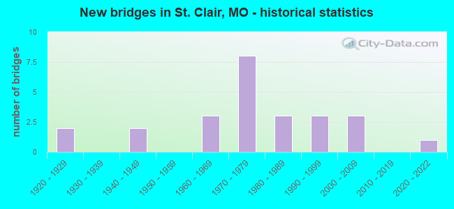
- New bridges - historical statistics
- 21920-1929
- 21940-1949
- 31960-1969
- 81970-1979
- 31980-1989
- 31990-1999
- 32000-2009
- 12020-2022

- Reconstructed bridges - Historical Statistics
- 11940-1949
- 01950-1959
- 01960-1969
- 11970-1979
- 21980-1989
- 01990-1999
- 22000-2009


- Bridge Condition - Deck
- 9.1%Excellent
- 54.5%Good
- 18.2%Satisfactory
- 18.2%Fair

- Bridge Condition - Superstructure
- 9.1%Excellent
- 18.2%Very good
- 45.5%Good
- 27.3%Fair

- Bridge Condition - Substructure
- 18.2%Excellent
- 36.4%Good
- 36.4%Satisfactory
- 9.1%Fair

- Bridge Condition - Channel
- 15.4%Good
- 46.2%Satisfactory
- 15.4%Fair
- 23.1%Poor

- Bridge Condition - Culverts
- 50.0%Satisfactory
- 33.3%Fair
- 16.7%Poor
Find on map >> Show street view
Structure Number: 1586, Location: S 8 T 41 N R 1 W (Lat: 38.315256, Lng: -91.053761), Route carried "on" structure: ServiceState highway 44, Year Built: 1967, Status: Open, Structure Length: 0.77m (2.53ft), Average Daily Traffic: 1,251 (year 2021), Truck Traffic: 23%, Average Future Daily Traffic: 2,377 (year 2041), Design Load: H 15, Features Intersected: HAMILTON BR
Minimum Vertical Clearance: 30+ m (98+ ft), Kilometerpoint: 35.470, Lanes on structure: 2, Owner: State Highway Agency, Approaching Roadway Width: 12.8m (42.0ft), Material/Design: Concrete continuous, Design/Construction: Culvert, Number Of Spans In Main Unit: 2, Length of Maximum Span: 3.7m (12.1ft), Curb-To-Curb Width: 14.7m (48.2ft), Out-to-Out Width: 15.3m (50.2ft)
Condition: Channel: Satisfactory, Culverts: Satisfactory, Operating Rating: 58.5 metric tons, Method Used To Determine Operating Rating: Load Factor (LF), Inventory Rating: 35.1 metric tons, Method Used To Determine Inventory Rating: Load Factor (LF), Structural Evaluation: Equal to present minimum criteria, Deck Geometry: Superior to present desirable criteria, Waterway Adequacy: Equal to present desirable criteria, Approach Roadway Alignment: Equal to present desirable criteria, Designated Inspection Frequency: Every 24 months, Inspection Date: December 2021
Find on map >> Show street view
Structure Number: 1699, Location: S 35 T 42 N R 1 W (Lat: 38.343533, Lng: -90.993797), Route carried "on" structure: State highway 30, Year Built: 1972, Year Reconstructed: 1984, Status: Open, Structure Length: 5.94m (19.49ft), Average Daily Traffic: 7,201 (year 2021), Truck Traffic: 8%, Average Future Daily Traffic: 13,682 (year 2041), Design Load: H 20, Features Intersected: IS 44
Minimum Vertical Clearance: 30+ m (98+ ft), Kilometerpoint: 0.047, Lanes on structure: 2, Lanes under structure: 4, Owner: State Highway Agency, Approaching Roadway Width: 12.2m (40.0ft), Material/Design: Steel continuous, Design/Construction: Stringer/Multi-beam, Number Of Spans In Main Unit: 4, Length of Maximum Span: 17.7m (58.1ft), Curb-To-Curb Width: 12.2m (40.0ft), Out-to-Out Width: 13.0m (42.7ft)
Condition: Deck: Fair, Superstructure: Fair, Substructure: Good, Operating Rating: 42.3 metric tons, Method Used To Determine Operating Rating: Allowable Stress (AS), Inventory Rating: 26.1 metric tons, Method Used To Determine Inventory Rating: Allowable Stress (AS), Structural Evaluation: Somewhat better than minimum adequacy, Deck Geometry: Somewhat better than minimum adequacy, Underclear: Equal to present minimum criteria, Approach Roadway Alignment: Equal to present desirable criteria, Designated Inspection Frequency: Every 24 months, Inspection Date: October 2021, Deck Structure Type: Concrete Cast-file-Place, Wearing Surface/Protective System: Wearing Surface: Latex Concrete, Membrane: Built-up, Deck Protection: Internally Sealed
Find on map >> Show street view
Structure Number: 17, Location: S 18 T 42 N R 1 E (Lat: 38.383656, Lng: -90.960639), Route carried "on" structure: State highway AH, Year Built: 1972, Year Reconstructed: 1985, Status: Posted for load-capacity, Structure Length: 6.07m (19.91ft), Average Daily Traffic: 739 (year 2021), Truck Traffic: 2%, Average Future Daily Traffic: 1,404 (year 2041), Design Load: H 15, Features Intersected: IS 44
Minimum Vertical Clearance: 30+ m (98+ ft), Kilometerpoint: 0.077, Lanes on structure: 2, Lanes under structure: 4, Owner: State Highway Agency, Approaching Roadway Width: 6.7m (22.0ft), Material/Design: Steel continuous, Design/Construction: Stringer/Multi-beam, Number Of Spans In Main Unit: 4, Length of Maximum Span: 18.3m (60.0ft), Curb-To-Curb Width: 8.5m (27.9ft), Out-to-Out Width: 9.4m (30.8ft)
Condition: Deck: Satisfactory, Superstructure: Fair, Substructure: Satisfactory, Operating Rating: 38.7 metric tons, Method Used To Determine Operating Rating: Allowable Stress (AS), Inventory Rating: 18.0 metric tons, Method Used To Determine Inventory Rating: Allowable Stress (AS), Structural Evaluation: Somewhat better than minimum adequacy, Deck Geometry: Somewhat better than minimum adequacy, Underclear: Equal to present minimum criteria, Approach Roadway Alignment: Equal to present minimum criteria, Designated Inspection Frequency: Every 24 months, Inspection Date: October 2021, Deck Structure Type: Concrete Cast-file-Place, Wearing Surface/Protective System: Wearing Surface: Other, Membrane: Built-up
Find on map >> Show street view
Structure Number: 19859, Location: S 14 T 42 N R 1 W (Lat: 38.391203, Lng: -91.005650), Route carried "on" structure: County highway 237, Year Built: 1994, Status: Open, Structure Length: 3.02m (9.91ft), Average Daily Traffic: 200 (year 2021), Truck Traffic: 12%, Average Future Daily Traffic: 360 (year 2041), Design Load: HS 20, Features Intersected: HAPPY SAC CR, Facility Carried by Structure: HAPPY SAC RD
Minimum Vertical Clearance: 30+ m (98+ ft), Kilometerpoint: 0.241, Lanes on structure: 2, Owner: County Highway Agency, Approaching Roadway Width: 6.1m (20.0ft), Skew: 3 degrees, Material/Design: Prestressed concrete continuous, Design/Construction: Stringer/Multi-beam, Number Of Spans In Main Unit: 2, Length of Maximum Span: 14.6m (47.9ft), Curb-To-Curb Width: 7.3m (24.0ft), Out-to-Out Width: 8.1m (26.6ft)
Condition: Deck: Good, Superstructure: Good, Substructure: Good, Channel: Fair, Operating Rating: 64.8 metric tons, Method Used To Determine Operating Rating: Allowable Stress (AS), Inventory Rating: 38.7 metric tons, Method Used To Determine Inventory Rating: Allowable Stress (AS), Structural Evaluation: Better than present minimum criteria, Deck Geometry: Somewhat better than minimum adequacy, Waterway Adequacy: Equal to present desirable criteria, Approach Roadway Alignment: Meets minimum limits, Designated Inspection Frequency: Every 24 months, Inspection Date: March 2021, Deck Structure Type: Concrete Cast-file-Place, Wearing Surface/Protective System: Wearing Surface: Monolithic Concrete, Deck Protection: Epoxy Coated Reinforcing
Find on map >> Show street view
Structure Number: 19976, Location: S 7 T 42 N R 1 E (Lat: 38.390797, Lng: -90.964653), Route carried "on" structure: County highway 242, Year Built: 1920, Year Reconstructed: 1986, Status: Open, Structure Length: 0.67m (2.20ft), Average Daily Traffic: 150 (year 2021), Truck Traffic: 8%, Average Future Daily Traffic: 270 (year 2041), Features Intersected: BIRCH CR, Facility Carried by Structure: SCHUCHART RD
Minimum Vertical Clearance: 30+ m (98+ ft), Kilometerpoint: 2.012, Lanes on structure: 2, Owner: County Highway Agency, Approaching Roadway Width: 7.3m (24.0ft), Material/Design: Steel, Design/Construction: Culvert, Number Of Spans In Main Unit: 3, Length of Maximum Span: 3.0m (9.8ft)
Condition: Channel: Satisfactory, Culverts: Fair, Operating Rating: 49.5 metric tons, Method Used To Determine Operating Rating: Allowable Stress (AS), Inventory Rating: 22.5 metric tons, Method Used To Determine Inventory Rating: Allowable Stress (AS), Structural Evaluation: Somewhat better than minimum adequacy, Waterway Adequacy: Equal to present minimum criteria, Approach Roadway Alignment: Equal to present desirable criteria, Designated Inspection Frequency: Every 24 months, Inspection Date: March 2021
Find on map >> Show street view
Structure Number: 20152, Location: S 29 T 42 N R 1 E (Lat: 38.357475, Lng: -90.942394), Route carried "on" structure: County highway 249, Year Built: 1995, Status: Open, Structure Length: 1.68m (5.51ft), Average Daily Traffic: 150 (year 2021), Truck Traffic: 25%, Average Future Daily Traffic: 270 (year 2041), Design Load: HS 20, Features Intersected: BRUSH CR, Facility Carried by Structure: BRUSH CR RD
Minimum Vertical Clearance: 30+ m (98+ ft), Kilometerpoint: 0.322, Lanes on structure: 2, Owner: County Highway Agency, Approaching Roadway Width: 7.3m (24.0ft), Material/Design: Prestressed concrete, Design/Construction: Stringer/Multi-beam, Number Of Spans In Main Unit: 1, Length of Maximum Span: 15.5m (50.9ft), Curb-To-Curb Width: 7.3m (24.0ft), Out-to-Out Width: 8.1m (26.6ft)
Condition: Deck: Good, Superstructure: Good, Substructure: Fair, Channel: Fair, Operating Rating: 62.1 metric tons, Method Used To Determine Operating Rating: Load Factor (LF), Inventory Rating: 36.0 metric tons, Method Used To Determine Inventory Rating: Load Factor (LF), Structural Evaluation: Somewhat better than minimum adequacy, Deck Geometry: Somewhat better than minimum adequacy, Waterway Adequacy: Equal to present desirable criteria, Approach Roadway Alignment: Equal to present desirable criteria, Designated Inspection Frequency: Every 24 months, Inspection Date: January 2021, Deck Structure Type: Concrete Cast-file-Place, Wearing Surface/Protective System: Deck Protection: Epoxy Coated Reinforcing
Find on map >> Show street view
Structure Number: 21823, Location: S 24 T 41 N R 1 W (Lat: 38.273558, Lng: -90.980586), Route carried "on" structure: County highway 325, Year Built: 1999, Status: Open, Structure Length: 1.74m (5.71ft), Average Daily Traffic: 50 (year 2021), Truck Traffic: 24%, Average Future Daily Traffic: 90 (year 2041), Design Load: HS 20, Features Intersected: CR TO MERAMEC RVR, Facility Carried by Structure: PLUM FORD RD
Minimum Vertical Clearance: 30+ m (98+ ft), Kilometerpoint: 1.529, Lanes on structure: 2, Owner: County Highway Agency, Approaching Roadway Width: 7.3m (24.0ft), Material/Design: Prestressed concrete, Design/Construction: Stringer/Multi-beam, Number Of Spans In Main Unit: 1, Length of Maximum Span: 16.5m (54.1ft), Curb-To-Curb Width: 7.3m (24.0ft), Out-to-Out Width: 8.1m (26.6ft)
Condition: Deck: Good, Superstructure: Very good, Substructure: Excellent, Channel: Good, Operating Rating: 59.4 metric tons, Method Used To Determine Operating Rating: Load Factor (LF), Inventory Rating: 36.0 metric tons, Method Used To Determine Inventory Rating: Load Factor (LF), Structural Evaluation: Equal to present desirable criteria, Deck Geometry: Equal to present minimum criteria, Waterway Adequacy: Superior to present desirable criteria, Approach Roadway Alignment: Equal to present desirable criteria, Designated Inspection Frequency: Every 24 months, Inspection Date: January 2021, Deck Structure Type: Concrete Cast-file-Place, Wearing Surface/Protective System: Deck Protection: Epoxy Coated Reinforcing
Find on map >> Show street view
Structure Number: 28692, Location: S 29 T 42 N R 1 E (Lat: 38.354556, Lng: -90.942417), Route carried "on" structure: County highway 249, Year Built: 2000, Status: Open, Structure Length: 2.07m (6.79ft), Average Daily Traffic: 50 (year 2021), Truck Traffic: 5%, Average Future Daily Traffic: 90 (year 2041), Design Load: HS 20, Features Intersected: BRUSH CR, Facility Carried by Structure: BRUSH CRK RD
Minimum Vertical Clearance: 30+ m (98+ ft), Kilometerpoint: 0.724, Lanes on structure: 2, Owner: County Highway Agency, Approaching Roadway Width: 6.1m (20.0ft), Skew: 3 degrees, Material/Design: Prestressed concrete, Design/Construction: Stringer/Multi-beam, Number Of Spans In Main Unit: 1, Length of Maximum Span: 19.8m (65.0ft), Curb-To-Curb Width: 7.3m (24.0ft), Out-to-Out Width: 8.1m (26.6ft)
Condition: Deck: Good, Superstructure: Good, Substructure: Good, Channel: Satisfactory, Operating Rating: 62.1 metric tons, Method Used To Determine Operating Rating: Load Factor (LF), Inventory Rating: 42.3 metric tons, Method Used To Determine Inventory Rating: Load Factor (LF), Structural Evaluation: Better than present minimum criteria, Deck Geometry: Equal to present minimum criteria, Waterway Adequacy: Superior to present desirable criteria, Approach Roadway Alignment: Equal to present minimum criteria, Designated Inspection Frequency: Every 24 months, Inspection Date: January 2021, Deck Structure Type: Concrete Cast-file-Place
Find on map >> Show street view
Structure Number: 29499, Location: S 14 T 42 N R 1 W (Lat: 38.383011, Lng: -91.000147), Route carried "on" structure: County highway , Year Built: 2003, Status: Open, Structure Length: 4.66m (15.29ft), Average Daily Traffic: 150 (year 2021), Truck Traffic: 10%, Average Future Daily Traffic: 270 (year 2041), Design Load: HS 20, Features Intersected: HAPPY SAC CR, Facility Carried by Structure: HAPPY SAC RD
Minimum Vertical Clearance: 30+ m (98+ ft), Kilometerpoint: 0.000, Lanes on structure: 2, Owner: County Highway Agency, Approaching Roadway Width: 7.3m (24.0ft), Material/Design: Prestressed concrete continuous, Design/Construction: Stringer/Multi-beam, Number Of Spans In Main Unit: 3, Length of Maximum Span: 19.8m (65.0ft), Curb-To-Curb Width: 7.3m (24.0ft), Out-to-Out Width: 8.3m (27.2ft)
Condition: Deck: Satisfactory, Superstructure: Good, Substructure: Satisfactory, Channel: Satisfactory, Operating Rating: 54.0 metric tons, Method Used To Determine Operating Rating: Load Factor (LF), Inventory Rating: 32.4 metric tons, Method Used To Determine Inventory Rating: Load Factor (LF), Structural Evaluation: Equal to present minimum criteria, Deck Geometry: Somewhat better than minimum adequacy, Waterway Adequacy: Superior to present desirable criteria, Approach Roadway Alignment: Somewhat better than minimum adequacy, Designated Inspection Frequency: Every 24 months, Inspection Date: March 2021, Deck Structure Type: Concrete Cast-file-Place
Find on map >> Show street view
Structure Number: 31437, Location: S 35 T 42 N R 1 W (Lat: 38.342778, Lng: -90.987853), Route carried "on" structure: State highway 30, Year Built: 2006, Status: Open, Structure Length: 5.94m (19.49ft), Average Daily Traffic: 14,488 (year 2021), Truck Traffic: 10%, Average Future Daily Traffic: 27,527 (year 2041), Design Load: HS 25 or greater, Features Intersected: BNSF RR
Minimum Vertical Clearance: 30+ m (98+ ft), Kilometerpoint: 0.845, Lanes on structure: 4, Base Highway Network: Yes, Owner: State Highway Agency, Approaching Roadway Width: 17.1m (56.1ft), Material/Design: Prestressed concrete continuous, Design/Construction: Stringer/Multi-beam, Number Of Spans In Main Unit: 3, Length of Maximum Span: 21.6m (70.9ft), Curb-To-Curb Width: 17.1m (56.1ft), Out-to-Out Width: 17.9m (58.7ft)
Condition: Deck: Good, Superstructure: Good, Substructure: Good, Operating Rating: 81.9 metric tons, Method Used To Determine Operating Rating: Load Factor (LF), Inventory Rating: 49.5 metric tons, Method Used To Determine Inventory Rating: Load Factor (LF), Structural Evaluation: Better than present minimum criteria, Deck Geometry: Somewhat better than minimum adequacy, Underclear: Equal to present desirable criteria, Approach Roadway Alignment: Equal to present desirable criteria, Designated Inspection Frequency: Every 24 months, Inspection Date: October 2021, Deck Structure Type: Concrete Cast-file-Place, Wearing Surface/Protective System: Wearing Surface: Monolithic Concrete, Deck Protection: Epoxy Coated Reinforcing
Find on map >> Show street view
Structure Number: 3528, Location: S 25 T 42 N R 1 W (Lat: 38.361747, Lng: -90.978997), Route carried "on" structure: State highway 47, Year Built: 1985, Status: Open, Structure Length: 6.04m (19.82ft), Average Daily Traffic: 12,455 (year 2021), Truck Traffic: 9%, Average Future Daily Traffic: 23,665 (year 2041), Design Load: HS 20+Mod, Features Intersected: IS 44
Minimum Vertical Clearance: 30+ m (98+ ft), Kilometerpoint: 113.538, Lanes on structure: 5, Lanes under structure: 4, Base Highway Network: Yes, Owner: State Highway Agency, Approaching Roadway Width: 20.7m (67.9ft), Material/Design: Steel continuous, Design/Construction: Stringer/Multi-beam, Number Of Spans In Main Unit: 2, Length of Maximum Span: 29.9m (98.1ft), Curb or Sidewalk Widths: Left: 0.2m (0.7ft), Right: 0.2m (0.7ft), Curb-To-Curb Width: 21.6m (70.9ft), Out-to-Out Width: 22.4m (73.5ft)
Condition: Deck: Fair, Superstructure: Fair, Substructure: Satisfactory, Operating Rating: 65.7 metric tons, Method Used To Determine Operating Rating: Load Factor (LF), Inventory Rating: 39.6 metric tons, Method Used To Determine Inventory Rating: Load Factor (LF), Structural Evaluation: Somewhat better than minimum adequacy, Deck Geometry: Somewhat better than minimum adequacy, Underclear: Equal to present minimum criteria, Approach Roadway Alignment: Equal to present desirable criteria, Designated Inspection Frequency: Every 24 months, Inspection Date: October 2021, Deck Structure Type: Concrete Cast-file-Place, Wearing Surface/Protective System: Wearing Surface: Monolithic Concrete, Deck Protection: Epoxy Coated Reinforcing
Find on map >> Show street view
Structure Number: 36287, Location: S 100 T 42 N R 1 W (Lat: 38.396294, Lng: -91.008833), Route carried "on" structure: State highway AD, Year Built: 2020, Status: Open, Structure Length: 5.89m (19.32ft), Average Daily Traffic: 469 (year 2021), Truck Traffic: 20%, Average Future Daily Traffic: 891 (year 2041), Features Intersected: HAPPY SOCK CR
Minimum Vertical Clearance: 30+ m (98+ ft), Kilometerpoint: 1.537, Lanes on structure: 2, Owner: State Highway Agency, Approaching Roadway Width: 8.5m (27.9ft), Skew: 5 degrees, Material/Design: Prestressed concrete, Design/Construction: Stringer/Multi-beam, Number Of Spans In Main Unit: 3, Length of Maximum Span: 20.4m (66.9ft), Curb-To-Curb Width: 8.5m (27.9ft), Out-to-Out Width: 9.3m (30.5ft)
Condition: Deck: Good, Superstructure: Very good, Substructure: Excellent, Channel: Good, Operating Rating: 54.0 metric tons, Method Used To Determine Operating Rating: Load Factor (LF), Inventory Rating: 29.7 metric tons, Method Used To Determine Inventory Rating: Load Factor (LF), Structural Evaluation: Better than present minimum criteria, Deck Geometry: Somewhat better than minimum adequacy, Waterway Adequacy: Superior to present desirable criteria, Approach Roadway Alignment: Equal to present desirable criteria, Designated Inspection Frequency: Every 24 months, Inspection Date: October 2021, Deck Structure Type: Concrete Cast-file-Place, Wearing Surface/Protective System: Wearing Surface: Monolithic Concrete, Deck Protection: Epoxy Coated Reinforcing
Find on map >> Show street view
Structure Number: 491, Location: S 8 T 41 N R 1 W (Lat: 38.314956, Lng: -91.053744), Route carried "on" structure: Interstate 44, Year Built: 1925, Year Reconstructed: 2006, Status: Open, Structure Length: 0.78m (2.56ft), Average Daily Traffic: 18,357 (year 2021), Truck Traffic: 35%, Average Future Daily Traffic: 38,550 (year 2041), Design Load: H 20, Features Intersected: HAMILTON BR
Minimum Vertical Clearance: 30+ m (98+ ft), Kilometerpoint: 93.981, Lanes on structure: 2, Base Highway Network: Yes, Owner: State Highway Agency, Approaching Roadway Width: 32.9m (107.9ft), Skew: 1 degrees, Material/Design: Concrete continuous, Design/Construction: Culvert, Number Of Spans In Main Unit: 2, Length of Maximum Span: 3.7m (12.1ft)
Condition: Channel: Satisfactory, Culverts: Satisfactory, Operating Rating: 72.0 metric tons, Method Used To Determine Operating Rating: Field evaluation and documented engineering judgment, Inventory Rating: 43.2 metric tons, Method Used To Determine Inventory Rating: Field evaluation and documented engineering judgment, Structural Evaluation: Equal to present minimum criteria, Waterway Adequacy: Equal to present desirable criteria, Approach Roadway Alignment: Equal to present desirable criteria, Designated Inspection Frequency: Every 24 months, Inspection Date: December 2021
Find on map >> Show street view
Structure Number: 6079, Location: S 8 T 41 N R 1 W (Lat: 38.312939, Lng: -91.055189), Route carried "on" structure: Interstate 44, Year Built: 1949, Status: Open, Structure Length: 0.90m (2.95ft), Average Daily Traffic: 17,659 (year 2021), Truck Traffic: 35%, Average Future Daily Traffic: 37,084 (year 2041), Design Load: H 20, Features Intersected: HAMILTON BR
Minimum Vertical Clearance: 30+ m (98+ ft), Kilometerpoint: 377.604, Lanes on structure: 2, Base Highway Network: Yes, Owner: State Highway Agency, Approaching Roadway Width: 32.9m (107.9ft), Skew: 4 degrees, Material/Design: Concrete continuous, Design/Construction: Culvert, Number Of Spans In Main Unit: 2, Length of Maximum Span: 3.0m (9.8ft)
Condition: Channel: Satisfactory, Culverts: Satisfactory, Operating Rating: 72.0 metric tons, Method Used To Determine Operating Rating: Field evaluation and documented engineering judgment, Inventory Rating: 43.2 metric tons, Method Used To Determine Inventory Rating: Field evaluation and documented engineering judgment, Structural Evaluation: Equal to present minimum criteria, Waterway Adequacy: Equal to present desirable criteria, Approach Roadway Alignment: Equal to present desirable criteria, Designated Inspection Frequency: Every 24 months, Inspection Date: December 2021
Find on map >> Show street view
Structure Number: 6226, Location: S 13 T 42 N R 1 W (Lat: 38.369497, Lng: -90.973417), Route carried "on" structure: Interstate 44, Year Built: 1949, Year Reconstructed: 1952, Status: Open, Structure Length: 0.89m (2.92ft), Average Daily Traffic: 28,209 (year 2021), Truck Traffic: 35%, Average Future Daily Traffic: 59,239 (year 2041), Design Load: H 20, Features Intersected: BR OF BOURBEUSE RV
Minimum Vertical Clearance: 30+ m (98+ ft), Kilometerpoint: 387.735, Lanes on structure: 4, Base Highway Network: Yes, Owner: State Highway Agency, Approaching Roadway Width: 32.9m (107.9ft), Skew: 24 degrees, Material/Design: Concrete continuous, Design/Construction: Culvert, Number Of Spans In Main Unit: 2, Length of Maximum Span: 3.0m (9.8ft)
Condition: Channel: Poor, Culverts: Poor, Operating Rating: 40.5 metric tons, Method Used To Determine Operating Rating: Load Factor (LF), Inventory Rating: 24.3 metric tons, Method Used To Determine Inventory Rating: Load Factor (LF), Structural Evaluation: Meets minimum limits, Waterway Adequacy: Equal to present desirable criteria, Approach Roadway Alignment: Equal to present desirable criteria, Length Of Structure Improvement: 0.16m (0.52ft), Designated Inspection Frequency: Every 24 months, Inspection Date: December 2021, Bridge Improvement Cost: $250,000, Roadway Improvement Cost: $25,000, Total Project Cost: $375,000 ( Estimate for 2022)
Find on map >> Show street view
Structure Number: 8225, Location: S 22 T 41 N R 1 W (Lat: 38.274664, Lng: -91.023303), Route carried "on" structure: State highway PP, Year Built: 1962, Status: Open, Structure Length: 0.71m (2.33ft), Average Daily Traffic: 348 (year 2021), Truck Traffic: 15%, Average Future Daily Traffic: 661 (year 2041), Design Load: H 15, Features Intersected: BR OF MERAMEC RVR
Minimum Vertical Clearance: 30+ m (98+ ft), Kilometerpoint: 10.540, Lanes on structure: 2, Owner: State Highway Agency, Approaching Roadway Width: 7.3m (24.0ft), Skew: 1 degrees, Material/Design: Concrete continuous, Design/Construction: Culvert, Number Of Spans In Main Unit: 2, Length of Maximum Span: 3.4m (11.2ft), Curb-To-Curb Width: 7.9m (25.9ft), Out-to-Out Width: 8.5m (27.9ft)
Condition: Channel: Poor, Culverts: Fair, Operating Rating: 57.6 metric tons, Method Used To Determine Operating Rating: Load Factor (LF), Inventory Rating: 35.1 metric tons, Method Used To Determine Inventory Rating: Load Factor (LF), Structural Evaluation: Somewhat better than minimum adequacy, Deck Geometry: Somewhat better than minimum adequacy, Waterway Adequacy: Equal to present desirable criteria, Approach Roadway Alignment: Equal to present minimum criteria, Designated Inspection Frequency: Every 24 months, Inspection Date: December 2021
Find on map >> Show street view
Structure Number: 8226, Location: S 11 T 41 N R 1 W (Lat: 38.307150, Lng: -90.992231), Route carried "on" structure: State highway PP, Year Built: 1962, Year Reconstructed: 2009, Status: Open, Structure Length: 2.35m (7.71ft), Average Daily Traffic: 348 (year 2021), Truck Traffic: 15%, Average Future Daily Traffic: 661 (year 2041), Design Load: H 15, Features Intersected: HOOSIER CR
Minimum Vertical Clearance: 30+ m (98+ ft), Kilometerpoint: 4.422, Lanes on structure: 2, Owner: State Highway Agency, Approaching Roadway Width: 6.7m (22.0ft), Material/Design: Prestressed concrete, Design/Construction: Box Beam or Girders - Multiple, Number Of Spans In Main Unit: 3, Length of Maximum Span: 10.4m (34.1ft), Curb-To-Curb Width: 6.7m (22.0ft), Out-to-Out Width: 6.7m (22.0ft)
Condition: Deck: Excellent, Superstructure: Excellent, Substructure: Satisfactory, Channel: Poor, Operating Rating: 65.7 metric tons, Method Used To Determine Operating Rating: Load Factor (LF), Inventory Rating: 38.7 metric tons, Method Used To Determine Inventory Rating: Load Factor (LF), Structural Evaluation: Equal to present minimum criteria, Deck Geometry: Meets minimum limits, Waterway Adequacy: Equal to present desirable criteria, Approach Roadway Alignment: Equal to present minimum criteria, Designated Inspection Frequency: Every 24 months, Inspection Date: October 2021, Deck Structure Type: Concrete Precast Panels, Wearing Surface/Protective System: Wearing Surface: Bituminous
Find on map >> Show street view
Structure Number: 1585, Location: S 8 T 41 N R 1 W (Lat: 38.310969, Lng: -91.059700), Route carried "under" structure: Interstate 44, Year Built: 1972, Structure Length: 0. m, Average Daily Traffic: 17,659 (year 2021), Truck Traffic: 35%, Features Intersected: IS 44, Facility Carried by Structure: ST LOUIS INN RD W
Minimum Vertical Clearance: 5.13m (16.83ft), Kilometerpoint: 377.167, Lanes on structure: 2, Lanes under structure: 2, Material/Design: Steel continuous, Design/Construction: Stringer/Multi-beam, Length of Maximum Span: 18.3m (60.0ft)
Find on map >> Show street view
Structure Number: 1585, Location: S 8 T 41 N R 1 W (Lat: 38.310969, Lng: -91.059700), Route carried "under" structure: Interstate 44, Year Built: 1972, Structure Length: 0. m, Average Daily Traffic: 18,357 (year 2021), Truck Traffic: 35%, Features Intersected: IS 44, Facility Carried by Structure: ST LOUIS INN RD W
Minimum Vertical Clearance: 5.13m (16.83ft), Kilometerpoint: 94.599, Lanes on structure: 2, Lanes under structure: 2, Material/Design: Steel continuous, Design/Construction: Stringer/Multi-beam, Length of Maximum Span: 18.3m (60.0ft)
Find on map >> Show street view
Structure Number: 1699, Location: S 35 T 42 N R 1 W (Lat: 38.343533, Lng: -90.993797), Route carried "under" structure: Interstate 44, Year Built: 1972, Structure Length: 0. m, Average Daily Traffic: 17,659 (year 2021), Truck Traffic: 35%, Features Intersected: IS 44, Facility Carried by Structure: MO 30 E
Minimum Vertical Clearance: 5.05m (16.57ft), Kilometerpoint: 384.341, Lanes on structure: 2, Lanes under structure: 2, Material/Design: Steel continuous, Design/Construction: Stringer/Multi-beam, Length of Maximum Span: 17.7m (58.1ft)
Find on map >> Show street view
Structure Number: 1699, Location: S 35 T 42 N R 1 W (Lat: 38.343533, Lng: -90.993797), Route carried "under" structure: Interstate 44, Year Built: 1972, Structure Length: 0. m, Average Daily Traffic: 19,513 (year 2021), Truck Traffic: 35%, Features Intersected: IS 44, Facility Carried by Structure: MO 30 E
Minimum Vertical Clearance: 5.05m (16.57ft), Kilometerpoint: 87.396, Lanes on structure: 2, Lanes under structure: 2, Material/Design: Steel continuous, Design/Construction: Stringer/Multi-beam, Length of Maximum Span: 17.7m (58.1ft)
Find on map >> Show street view
Structure Number: 17, Location: S 18 T 42 N R 1 E (Lat: 38.383656, Lng: -90.960639), Route carried "under" structure: Interstate 44, Year Built: 1972, Structure Length: 0. m, Average Daily Traffic: 13,985 (year 2021), Truck Traffic: 35%, Features Intersected: IS 44, Facility Carried by Structure: RT AH E
Minimum Vertical Clearance: 5.08m (16.67ft), Kilometerpoint: 389.769, Lanes on structure: 2, Lanes under structure: 2, Material/Design: Steel continuous, Design/Construction: Stringer/Multi-beam, Length of Maximum Span: 18.3m (60.0ft)
Find on map >> Show street view
Structure Number: 17, Location: S 18 T 42 N R 1 E (Lat: 38.383656, Lng: -90.960639), Route carried "under" structure: Interstate 44, Year Built: 1972, Structure Length: 0. m, Average Daily Traffic: 14,838 (year 2021), Truck Traffic: 35%, Features Intersected: IS 44, Facility Carried by Structure: RT AH E
Minimum Vertical Clearance: 5.06m (16.60ft), Kilometerpoint: 81.954, Lanes on structure: 2, Lanes under structure: 2, Material/Design: Steel continuous, Design/Construction: Stringer/Multi-beam, Length of Maximum Span: 18.3m (60.0ft)
Find on map >> Show street view
Structure Number: 3528, Location: S 25 T 42 N R 1 W (Lat: 38.361747, Lng: -90.978997), Route carried "under" structure: Interstate 44, Year Built: 1985, Structure Length: 0. m, Average Daily Traffic: 14,224 (year 2021), Truck Traffic: 35%, Features Intersected: IS 44, Facility Carried by Structure: MO 47 S
Minimum Vertical Clearance: 5.06m (16.60ft), Kilometerpoint: 84.988, Lanes on structure: 5, Lanes under structure: 2, Material/Design: Steel continuous, Design/Construction: Stringer/Multi-beam, Length of Maximum Span: 29.9m (98.1ft)
Find on map >> Show street view
Structure Number: 3528, Location: S 25 T 42 N R 1 W (Lat: 38.361747, Lng: -90.978997), Route carried "under" structure: Interstate 44, Year Built: 1985, Structure Length: 0. m, Average Daily Traffic: 15,844 (year 2021), Truck Traffic: 35%, Features Intersected: IS 44, Facility Carried by Structure: MO 47 S
Minimum Vertical Clearance: 5.03m (16.50ft), Kilometerpoint: 386.744, Lanes on structure: 5, Lanes under structure: 2, Material/Design: Steel continuous, Design/Construction: Stringer/Multi-beam, Length of Maximum Span: 29.9m (98.1ft)