Bridge Statistics for St. Clair Shores, Michigan (MI)
Condition, Traffic, Stress, Structural Evaluation, Project Costs
- National Bridge Inventory (NBI) Statistics
- 36Number of bridges
- 315ft / 95.8mTotal length
- $406,000Total costs
- 2,457,371Total average daily traffic
- 115,624Total average daily truck traffic
- National Bridge Inventory (NBI) Registered Bridges for St. Clair Shores
- No street view available for this location
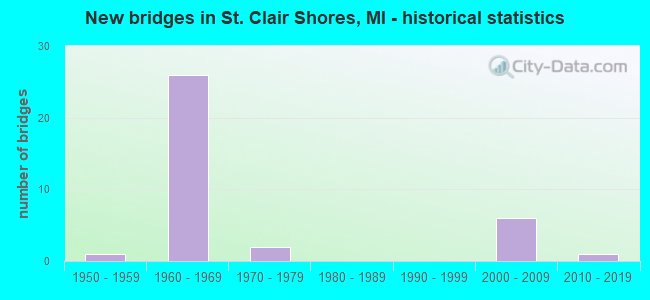
- New bridges - historical statistics
- 11950-1959
- 261960-1969
- 21970-1979
- 62000-2009
- 12010-2019
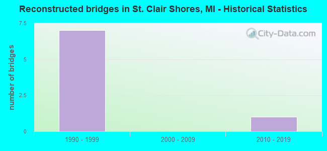
- Reconstructed bridges - Historical Statistics
- 71990-1999
- 02000-2009
- 12010-2019
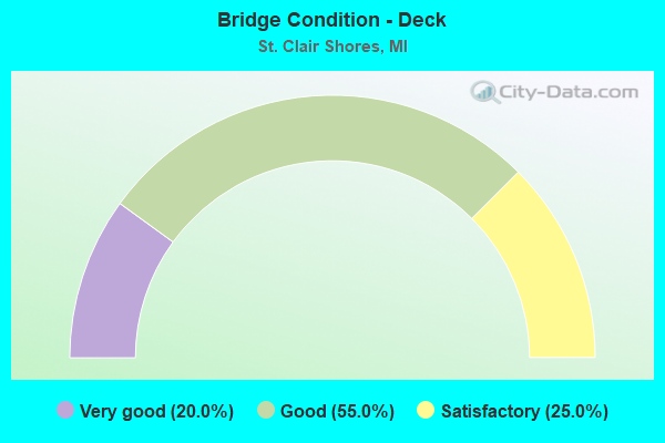
- Bridge Condition - Deck
- 20.0%Very good
- 55.0%Good
- 25.0%Satisfactory
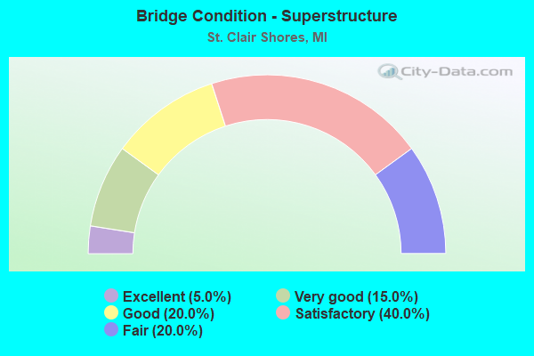
- Bridge Condition - Superstructure
- 5.0%Excellent
- 15.0%Very good
- 20.0%Good
- 40.0%Satisfactory
- 20.0%Fair
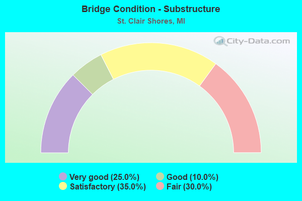
- Bridge Condition - Substructure
- 25.0%Very good
- 10.0%Good
- 35.0%Satisfactory
- 30.0%Fair
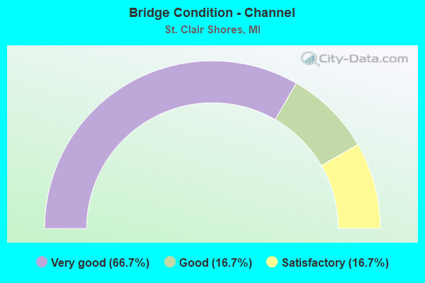
- Bridge Condition - Channel
- 66.7%Very good
- 16.7%Good
- 16.7%Satisfactory
Find on map >> Show street view
Structure Number: 309, Location: WATSON TWP SEC 32 (Lat: 42.507964, Lng: -85.753467), Route carried "on" structure: County highway , Year Built: 2005, Status: Open, Structure Length: 1.89m (6.20ft), Average Daily Traffic: 176 (year 2002), Truck Traffic: 7%, Average Future Daily Traffic: 265 (year 2021), Design Load: HS 20, Features Intersected: MINER CREEK, Facility Carried by Structure: 112TH AVENUE
Minimum Vertical Clearance: 30.48m (100.00ft), Kilometerpoint: 2.123, Lanes on structure: 2, Owner: County Highway Agency, Approaching Roadway Width: 9.1m (29.9ft), Skew: 2 degrees, Material/Design: Prestressed concrete, Design/Construction: Box Beam or Girders - Multiple, Number Of Spans In Main Unit: 1, Length of Maximum Span: 17.7m (58.1ft), Curb-To-Curb Width: 9.4m (30.8ft), Out-to-Out Width: 10.5m (34.4ft)
Condition: Deck: Very good, Superstructure: Very good, Substructure: Very good, Channel: Very good, Operating Rating: 97.2 metric tons, Method Used To Determine Operating Rating: Load Factor (LF) rating reported by rating factor (RF) method using MS18 loading, Inventory Rating: 59.3 metric tons, Method Used To Determine Inventory Rating: Load Factor (LF) rating reported by rating factor (RF) method using MS18 loading, Structural Evaluation: Equal to present desirable criteria, Deck Geometry: Equal to present minimum criteria, Waterway Adequacy: Equal to present desirable criteria, Approach Roadway Alignment: Equal to present desirable criteria, Designated Inspection Frequency: Every 24 months, Inspection Date: April 2021, Deck Structure Type: Concrete Cast-file-Place, Wearing Surface/Protective System: Wearing Surface: Integral Concrete, Deck Protection: Epoxy Coated Reinforcing
Find on map >> Show street view
Structure Number: 615, Location: 4.0 MI SW OF PINCONNING (Lat: 43.844464, Lng: -84.020425), Route carried "on" structure: Interstate 75, Year Built: 2011, Status: Open, Structure Length: 1.98m (6.50ft), Average Daily Traffic: 15,522 (year 2007), Truck Traffic: 8%, Average Future Daily Traffic: 16,605 (year 2030), Design Load: HL 93, Features Intersected: PINCONNING RIVER
Minimum Vertical Clearance: 30.48m (100.00ft), Kilometerpoint: 38.103, Lanes on structure: 2, Base Highway Network: Yes (Inventory Route: 76, Subroute: 1), Owner: State Highway Agency, Approaching Roadway Width: 12.8m (42.0ft), Material/Design: Prestressed concrete, Design/Construction: Stringer/Multi-beam, Number Of Spans In Main Unit: 1, Length of Maximum Span: 19.1m (62.7ft), Curb-To-Curb Width: 14.0m (45.9ft), Out-to-Out Width: 14.9m (48.9ft)
Condition: Deck: Good, Superstructure: Excellent, Substructure: Very good, Channel: Satisfactory, Operating Rating: 77.8 metric tons, Method Used To Determine Operating Rating: Load and Resistance Factor Rating (LRFR) rating reported by rating factor(RF) method using HL-93 loadings, Inventory Rating: 45.4 metric tons, Method Used To Determine Inventory Rating: Load and Resistance Factor Rating (LRFR) rating reported by rating factor(RF) method using HL-93 loadings, Structural Evaluation: Equal to present desirable criteria, Deck Geometry: Superior to present desirable criteria, Waterway Adequacy: Equal to present desirable criteria, Approach Roadway Alignment: Equal to present desirable criteria, Designated Inspection Frequency: Every 24 months, Inspection Date: August 2021, Deck Structure Type: Concrete Cast-file-Place, Wearing Surface/Protective System: Wearing Surface: Monolithic Concrete, Deck Protection: Epoxy Coated Reinforcing
Find on map >> Show street view
Structure Number: 642, Location: 1.7 MI S OF KAWKAWLIN (Lat: 43.638708, Lng: -83.972806), Route carried "on" structure: Interstate 75, Year Built: 1968, Status: Open, Structure Length: 4.56m (14.96ft), Average Daily Traffic: 11,225 (year 2019), Truck Traffic: 9%, Average Future Daily Traffic: 12,909 (year 2039), Design Load: HS 20+Mod, Features Intersected: WHEELER ROAD
Minimum Vertical Clearance: 30.48m (100.00ft), Kilometerpoint: 13.749, Lanes on structure: 2, Lanes under structure: 2, Base Highway Network: Yes (Inventory Route: 76, Subroute: 1), Owner: State Highway Agency, Approaching Roadway Width: 12.2m (40.0ft), Skew: 4 degrees, Material/Design: Steel, Design/Construction: Stringer/Multi-beam, Number Of Spans In Main Unit: 3, Length of Maximum Span: 19.5m (64.0ft), Curb-To-Curb Width: 11.8m (38.7ft), Out-to-Out Width: 12.8m (42.0ft)
Condition: Deck: Good, Superstructure: Fair, Substructure: Good, Operating Rating: 62.5 metric tons, Method Used To Determine Operating Rating: Load Factor (LF) rating reported by rating factor (RF) method using MS18 loading, Inventory Rating: 37.3 metric tons, Method Used To Determine Inventory Rating: Load Factor (LF) rating reported by rating factor (RF) method using MS18 loading, Structural Evaluation: Somewhat better than minimum adequacy, Deck Geometry: Equal to present minimum criteria, Underclear: Equal to present minimum criteria, Approach Roadway Alignment: Equal to present desirable criteria, Designated Inspection Frequency: Every 24 months, Inspection Date: August 2021, Deck Structure Type: Concrete Cast-file-Place, Wearing Surface/Protective System: Wearing Surface: Latex Concrete, Deck Protection: Epoxy Coated Reinforcing
Find on map >> Show street view
Structure Number: 6123, Location: IN ST CLAIR SHORES (Lat: 42.492981, Lng: -82.916853), Route carried "on" structure: Ramp Interstate 696, Year Built: 1972, Status: Open, Structure Length: 9.02m (29.59ft), Average Daily Traffic: 27,250 (year 2009), Truck Traffic: 5%, Average Future Daily Traffic: 27,350 (year 2011), Design Load: HS 20, Features Intersected: I-94
Minimum Vertical Clearance: 30.48m (100.00ft), Kilometerpoint: 0.166, Lanes on structure: 2, Lanes under structure: 6, Owner: State Highway Agency, Approaching Roadway Width: 13.7m (44.9ft), Skew: 5 degrees, Material/Design: Steel, Design/Construction: Stringer/Multi-beam, Number Of Spans In Main Unit: 4, Length of Maximum Span: 35.6m (116.8ft), Curb or Sidewalk Widths: Left: 3.7m (12.1ft), Right: 1.2m (3.9ft), Curb-To-Curb Width: 8.4m (27.6ft), Out-to-Out Width: 14.1m (46.3ft)
Condition: Deck: Satisfactory, Superstructure: Good, Substructure: Satisfactory, Operating Rating: 71.0 metric tons, Method Used To Determine Operating Rating: Load Factor (LF), Inventory Rating: 42.6 metric tons, Method Used To Determine Inventory Rating: Load Factor (LF), Structural Evaluation: Equal to present minimum criteria, Deck Geometry: High priority of corrective action, Underclear: High priority of corrective action, Approach Roadway Alignment: Equal to present desirable criteria, Length Of Structure Improvement: 9.02m (29.59ft), Designated Inspection Frequency: Every 24 months, Inspection Date: June 2020, Bridge Improvement Cost: $200,000, Roadway Improvement Cost: $11,000, Total Project Cost: $133,000, Deck Structure Type: Concrete Cast-file-Place, Wearing Surface/Protective System: Wearing Surface: Epoxy Overlay
Find on map >> Show street view
Structure Number: 6147, Location: IN ST CLAIR SHORES (Lat: 42.464586, Lng: -82.921642), Route carried "on" structure: Ramp City street , Year Built: 1964, Status: Open, Structure Length: 5.61m (18.41ft), Average Daily Traffic: 1,800 (year 1980), Truck Traffic: 3%, Average Future Daily Traffic: 5,000 (year 2020), Design Load: HS 20+Mod, Features Intersected: I-94, Facility Carried by Structure: 9 MI RD SB TURN RD
Minimum Vertical Clearance: 30.48m (100.00ft), Kilometerpoint: 0.060, Lanes on structure: 1, Lanes under structure: 6, Owner: State Highway Agency, Approaching Roadway Width: 5.4m (17.7ft), Material/Design: Steel, Design/Construction: Stringer/Multi-beam, Number Of Spans In Main Unit: 4, Length of Maximum Span: 19.2m (63.0ft), Curb-To-Curb Width: 7.7m (25.3ft), Out-to-Out Width: 8.7m (28.5ft)
Condition: Deck: Satisfactory, Superstructure: Satisfactory, Substructure: Fair, Operating Rating: 97.2 metric tons, Method Used To Determine Operating Rating: Load Factor (LF) rating reported by rating factor (RF) method using MS18 loading, Inventory Rating: 61.9 metric tons, Method Used To Determine Inventory Rating: Load Factor (LF) rating reported by rating factor (RF) method using MS18 loading, Structural Evaluation: Somewhat better than minimum adequacy, Deck Geometry: Better than present minimum criteria, Underclear: High priority of corrective action, Approach Roadway Alignment: Better than present minimum criteria, Designated Inspection Frequency: Every 24 months, Inspection Date: July 2021, Deck Structure Type: Concrete Cast-file-Place, Wearing Surface/Protective System: Wearing Surface: Latex Concrete, Deck Protection: Epoxy Coated Reinforcing
Find on map >> Show street view
Structure Number: 6148, Location: W LTS OF ST CLAIR SHORES (Lat: 42.465622, Lng: -82.921014), Route carried "on" structure: City street 2057, Year Built: 1967, Year Reconstructed: 2002, Status: Open, Structure Length: 6.38m (20.93ft), Average Daily Traffic: 20,830 (year 1974), Truck Traffic: 3%, Average Future Daily Traffic: 30,684 (year 2020), Design Load: HS 20+Mod, Features Intersected: I-94, Facility Carried by Structure: 9 MI RD
Minimum Vertical Clearance: 30.48m (100.00ft), Kilometerpoint: 13.408, Lanes on structure: 4, Lanes under structure: 6, Owner: State Highway Agency, Approaching Roadway Width: 14.9m (48.9ft), Skew: 2 degrees, Material/Design: Steel, Design/Construction: Stringer/Multi-beam, Number Of Spans In Main Unit: 4, Length of Maximum Span: 21.9m (71.9ft), Curb or Sidewalk Widths: Left: 1.8m (5.9ft), Right: 1.8m (5.9ft), Curb-To-Curb Width: 14.6m (47.9ft), Out-to-Out Width: 19.0m (62.3ft)
Condition: Deck: Good, Superstructure: Satisfactory, Substructure: Fair, Operating Rating: 96.0 metric tons, Method Used To Determine Operating Rating: Load Factor (LF), Inventory Rating: 57.5 metric tons, Method Used To Determine Inventory Rating: Load Factor (LF), Structural Evaluation: Somewhat better than minimum adequacy, Deck Geometry: High priority of replacement, Underclear: High priority of corrective action, Approach Roadway Alignment: Better than present minimum criteria, Designated Inspection Frequency: Every 24 months, Inspection Date: July 2021, Deck Structure Type: Concrete Cast-file-Place, Wearing Surface/Protective System: Wearing Surface: Monolithic Concrete, Deck Protection: Epoxy Coated Reinforcing
Find on map >> Show street view
Structure Number: 6149, Location: W LTS OF ST CLAIR SHORES (Lat: 42.466628, Lng: -82.920353), Route carried "on" structure: Ramp City street , Year Built: 1967, Status: Open, Structure Length: 5.61m (18.41ft), Average Daily Traffic: 4,900 (year 0000), Truck Traffic: 3%, Average Future Daily Traffic: 5,000 (year 2020), Design Load: HS 20+Mod, Features Intersected: I-94, Facility Carried by Structure: 9 MI RD NB TURN RD
Minimum Vertical Clearance: 30.48m (100.00ft), Kilometerpoint: 0.068, Lanes on structure: 1, Lanes under structure: 6, Owner: State Highway Agency, Approaching Roadway Width: 5.1m (16.7ft), Material/Design: Steel, Design/Construction: Stringer/Multi-beam, Number Of Spans In Main Unit: 4, Length of Maximum Span: 19.2m (63.0ft), Curb or Sidewalk Widths: Left: 0.4m (1.3ft), Right: 0.4m (1.3ft), Curb-To-Curb Width: 7.7m (25.3ft), Out-to-Out Width: 8.7m (28.5ft)
Condition: Deck: Satisfactory, Superstructure: Satisfactory, Substructure: Fair, Operating Rating: 76.1 metric tons, Method Used To Determine Operating Rating: Load Factor (LF) rating reported by rating factor (RF) method using MS18 loading, Inventory Rating: 45.4 metric tons, Method Used To Determine Inventory Rating: Load Factor (LF) rating reported by rating factor (RF) method using MS18 loading, Structural Evaluation: Somewhat better than minimum adequacy, Deck Geometry: Better than present minimum criteria, Underclear: High priority of corrective action, Approach Roadway Alignment: Equal to present desirable criteria, Length Of Structure Improvement: 5.61m (18.41ft), Designated Inspection Frequency: Every 24 months, Inspection Date: July 2021, Bridge Improvement Cost: $54,000, Roadway Improvement Cost: $4,000, Total Project Cost: $50,000, Deck Structure Type: Concrete Cast-file-Place, Wearing Surface/Protective System: Deck Protection: Epoxy Coated Reinforcing
Find on map >> Show street view
Structure Number: 615, Location: W LTS OF ST CLAIR SHORES (Lat: 42.473028, Lng: -82.916544), Route carried "on" structure: City street , Year Built: 1966, Year Reconstructed: 2002, Status: Open, Structure Length: 5.98m (19.62ft), Average Daily Traffic: 1,920 (year 1995), Truck Traffic: 3%, Average Future Daily Traffic: 2,973 (year 2019), Design Load: H 20, Features Intersected: I-94, Facility Carried by Structure: STEPHENS DR
Minimum Vertical Clearance: 30.48m (100.00ft), Kilometerpoint: 5.998, Lanes on structure: 2, Lanes under structure: 6, Owner: State Highway Agency, Approaching Roadway Width: 10.0m (32.8ft), Skew: 1 degrees, Material/Design: Steel, Design/Construction: Stringer/Multi-beam, Number Of Spans In Main Unit: 4, Length of Maximum Span: 19.8m (65.0ft), Curb or Sidewalk Widths: Left: 1.8m (5.9ft), Right: 1.8m (5.9ft), Curb-To-Curb Width: 7.9m (25.9ft), Out-to-Out Width: 12.3m (40.4ft)
Condition: Deck: Very good, Superstructure: Satisfactory, Substructure: Satisfactory, Operating Rating: 99.5 metric tons, Method Used To Determine Operating Rating: Load Factor (LF), Inventory Rating: 59.6 metric tons, Method Used To Determine Inventory Rating: Load Factor (LF), Structural Evaluation: Equal to present minimum criteria, Deck Geometry: Meets minimum limits, Underclear: High priority of corrective action, Approach Roadway Alignment: Better than present minimum criteria, Designated Inspection Frequency: Every 24 months, Inspection Date: July 2021, Deck Structure Type: Concrete Cast-file-Place, Wearing Surface/Protective System: Deck Protection: Epoxy Coated Reinforcing
Find on map >> Show street view
Structure Number: 6151, Location: W LTS OF ST CLAIR SHORES (Lat: 42.479536, Lng: -82.916469), Route carried "on" structure: Ramp County highway 2058, Year Built: 2002, Status: Open, Structure Length: 5.56m (18.24ft), Average Daily Traffic: 4,800 (year 0000), Truck Traffic: 3%, Average Future Daily Traffic: 3,250 (year 2020), Design Load: HS 20+Mod, Features Intersected: I-94, Facility Carried by Structure: 10 MI RD S INT
Minimum Vertical Clearance: 30.48m (100.00ft), Kilometerpoint: 0.061, Lanes on structure: 1, Lanes under structure: 6, Owner: State Highway Agency, Approaching Roadway Width: 7.9m (25.9ft), Material/Design: Steel, Design/Construction: Stringer/Multi-beam, Number Of Spans In Main Unit: 4, Length of Maximum Span: 19.2m (63.0ft), Curb or Sidewalk Widths: Left: 0.5m (1.6ft), Right: 0.5m (1.6ft), Curb-To-Curb Width: 7.7m (25.3ft), Out-to-Out Width: 8.7m (28.5ft)
Condition: Deck: Good, Superstructure: Satisfactory, Substructure: Satisfactory, Inventory Rating: 63.8 metric tons, Method Used To Determine Inventory Rating: Load Factor (LF), Structural Evaluation: Equal to present minimum criteria, Deck Geometry: Better than present minimum criteria, Underclear: High priority of corrective action, Approach Roadway Alignment: Equal to present desirable criteria, Designated Inspection Frequency: Every 24 months, Inspection Date: July 2021, Deck Structure Type: Concrete Cast-file-Place, Wearing Surface/Protective System: Wearing Surface: Monolithic Concrete, Deck Protection: Epoxy Coated Reinforcing
Find on map >> Show street view
Structure Number: 6152, Location: W LTS OF ST CLAIR SHORES (Lat: 42.480450, Lng: -82.916528), Route carried "on" structure: County highway 2058, Year Built: 1965, Year Reconstructed: 2002, Status: Open, Structure Length: 5.64m (18.50ft), Average Daily Traffic: 19,070 (year 0000), Truck Traffic: 3%, Average Future Daily Traffic: 6,500 (year 2020), Design Load: H 20, Features Intersected: I-94, Facility Carried by Structure: 10 MI RD
Minimum Vertical Clearance: 30.48m (100.00ft), Kilometerpoint: 13.822, Lanes on structure: 4, Lanes under structure: 6, Owner: State Highway Agency, Approaching Roadway Width: 14.9m (48.9ft), Material/Design: Steel, Design/Construction: Stringer/Multi-beam, Number Of Spans In Main Unit: 4, Length of Maximum Span: 19.3m (63.3ft), Curb or Sidewalk Widths: Left: 1.8m (5.9ft), Right: 1.8m (5.9ft), Curb-To-Curb Width: 14.6m (47.9ft), Out-to-Out Width: 19.0m (62.3ft)
Condition: Deck: Good, Superstructure: Fair, Substructure: Fair, Operating Rating: 99.7 metric tons, Method Used To Determine Operating Rating: Load Factor (LF), Inventory Rating: 59.7 metric tons, Method Used To Determine Inventory Rating: Load Factor (LF), Structural Evaluation: Somewhat better than minimum adequacy, Deck Geometry: High priority of replacement, Underclear: High priority of corrective action, Approach Roadway Alignment: Equal to present desirable criteria, Designated Inspection Frequency: Every 24 months, Inspection Date: June 2020, Deck Structure Type: Concrete Cast-file-Place, Wearing Surface/Protective System: Wearing Surface: Monolithic Concrete, Deck Protection: Epoxy Coated Reinforcing
Find on map >> Show street view
Structure Number: 6153, Location: W LTS OF ST CLAIR SHORES (Lat: 42.481422, Lng: -82.916658), Route carried "on" structure: Ramp County highway 2058, Year Built: 1965, Year Reconstructed: 2002, Status: Open, Structure Length: 5.61m (18.41ft), Average Daily Traffic: 3,400 (year 0000), Truck Traffic: 3%, Average Future Daily Traffic: 3,250 (year 2020), Design Load: HS 20+Mod, Features Intersected: I-94, Facility Carried by Structure: 10 MI RD N INT
Minimum Vertical Clearance: 30.48m (100.00ft), Kilometerpoint: 0.060, Lanes on structure: 1, Lanes under structure: 6, Owner: State Highway Agency, Approaching Roadway Width: 6.7m (22.0ft), Material/Design: Steel, Design/Construction: Stringer/Multi-beam, Number Of Spans In Main Unit: 4, Length of Maximum Span: 19.2m (63.0ft), Curb or Sidewalk Widths: Left: 0.9m (3.0ft), Right: 0.4m (1.3ft), Curb-To-Curb Width: 7.7m (25.3ft), Out-to-Out Width: 8.7m (28.5ft)
Condition: Deck: Good, Superstructure: Good, Substructure: Good, Operating Rating: 74.8 metric tons, Method Used To Determine Operating Rating: Load Factor (LF) rating reported by rating factor (RF) method using MS18 loading, Inventory Rating: 44.7 metric tons, Method Used To Determine Inventory Rating: Load Factor (LF) rating reported by rating factor (RF) method using MS18 loading, Structural Evaluation: Better than present minimum criteria, Deck Geometry: Better than present minimum criteria, Underclear: High priority of corrective action, Approach Roadway Alignment: Equal to present desirable criteria, Designated Inspection Frequency: Every 24 months, Inspection Date: July 2021, Deck Structure Type: Concrete Cast-file-Place, Wearing Surface/Protective System: Wearing Surface: Monolithic Concrete, Deck Protection: Epoxy Coated Reinforcing
Find on map >> Show street view
Structure Number: 6154, Location: W LTS OF ST CLAIR SHORES (Lat: 42.487853, Lng: -82.917183), Route carried "on" structure: City street , Year Built: 1967, Year Reconstructed: 1996, Status: Open, Structure Length: 6.39m (20.96ft), Average Daily Traffic: 1,850 (year 1996), Truck Traffic: 10%, Average Future Daily Traffic: 13,600 (year 2015), Design Load: HS 20, Features Intersected: I-94, Facility Carried by Structure: FRAZHO RD
Minimum Vertical Clearance: 30.48m (100.00ft), Kilometerpoint: 7.358, Lanes on structure: 2, Lanes under structure: 8, Owner: State Highway Agency, Approaching Roadway Width: 8.5m (27.9ft), Material/Design: Steel, Design/Construction: Stringer/Multi-beam, Number Of Spans In Main Unit: 4, Length of Maximum Span: 23.0m (75.5ft), Curb or Sidewalk Widths: Left: 1.8m (5.9ft), Right: 1.8m (5.9ft), Curb-To-Curb Width: 8.5m (27.9ft), Out-to-Out Width: 12.9m (42.3ft)
Condition: Deck: Good, Superstructure: Satisfactory, Substructure: Satisfactory, Operating Rating: 46.3 metric tons, Method Used To Determine Operating Rating: Load and Resistance Factor Rating (LRFR) rating reported by rating factor(RF) method using HL-93 loadings, Inventory Rating: 35.6 metric tons, Method Used To Determine Inventory Rating: Load and Resistance Factor Rating (LRFR) rating reported by rating factor(RF) method using HL-93 loadings, Structural Evaluation: Equal to present minimum criteria, Deck Geometry: Somewhat better than minimum adequacy, Underclear: High priority of corrective action, Approach Roadway Alignment: Better than present minimum criteria, Length Of Structure Improvement: 6.40m (21.00ft), Designated Inspection Frequency: Every 24 months, Inspection Date: June 2021, Bridge Improvement Cost: $270,000, Roadway Improvement Cost: $19,000, Total Project Cost: $223,000, Deck Structure Type: Concrete Cast-file-Place, Wearing Surface/Protective System: Wearing Surface: Monolithic Concrete, Deck Protection: Epoxy Coated Reinforcing
Find on map >> Show street view
Structure Number: 6155, Location: W LTS OF ST CLAIR SHORES (Lat: 42.495164, Lng: -82.916947), Route carried "on" structure: ServiceCity street , Year Built: 1967, Year Reconstructed: 2010, Status: Open, Structure Length: 6.28m (20.60ft), Average Daily Traffic: 19,800 (year 2009), Truck Traffic: 4%, Average Future Daily Traffic: 20,000 (year 2011), Design Load: HS 20, Features Intersected: I-94, Facility Carried by Structure: 11 MI RD
Minimum Vertical Clearance: 30.48m (100.00ft), Kilometerpoint: 0.443, Lanes on structure: 4, Lanes under structure: 7, Owner: State Highway Agency, Approaching Roadway Width: 23.1m (75.8ft), Material/Design: Steel, Design/Construction: Stringer/Multi-beam, Number Of Spans In Main Unit: 4, Length of Maximum Span: 22.8m (74.8ft), Curb or Sidewalk Widths: Left: 1.8m (5.9ft), Right: 1.8m (5.9ft), Curb-To-Curb Width: 19.5m (64.0ft), Out-to-Out Width: 23.9m (78.4ft)
Condition: Deck: Good, Superstructure: Satisfactory, Substructure: Satisfactory, Operating Rating: 89.7 metric tons, Method Used To Determine Operating Rating: Load Factor (LF), Inventory Rating: 53.8 metric tons, Method Used To Determine Inventory Rating: Load Factor (LF), Structural Evaluation: Equal to present minimum criteria, Deck Geometry: Better than present minimum criteria, Underclear: High priority of corrective action, Approach Roadway Alignment: Superior to present desirable criteria, Designated Inspection Frequency: Every 24 months, Inspection Date: June 2021, Deck Structure Type: Concrete Cast-file-Place, Wearing Surface/Protective System: Wearing Surface: Monolithic Concrete
Find on map >> Show street view
Structure Number: 6156, Location: W LTS OF ST CLAIR SHORES (Lat: 42.502617, Lng: -82.917872), Route carried "on" structure: City street , Year Built: 1967, Year Reconstructed: 1996, Status: Open, Structure Length: 6.55m (21.49ft), Average Daily Traffic: 2,270 (year 1996), Truck Traffic: 10%, Average Future Daily Traffic: 9,200 (year 2015), Design Load: HS 20, Features Intersected: I-94, Facility Carried by Structure: MARTIN RD
Minimum Vertical Clearance: 30.48m (100.00ft), Kilometerpoint: 5.710, Lanes on structure: 2, Lanes under structure: 8, Owner: State Highway Agency, Approaching Roadway Width: 8.5m (27.9ft), Material/Design: Steel, Design/Construction: Stringer/Multi-beam, Number Of Spans In Main Unit: 4, Length of Maximum Span: 22.8m (74.8ft), Curb or Sidewalk Widths: Left: 1.8m (5.9ft), Right: 1.8m (5.9ft), Curb-To-Curb Width: 8.5m (27.9ft), Out-to-Out Width: 12.9m (42.3ft)
Condition: Deck: Satisfactory, Superstructure: Good, Substructure: Fair, Operating Rating: 93.7 metric tons, Method Used To Determine Operating Rating: Load Factor (LF), Inventory Rating: 56.1 metric tons, Method Used To Determine Inventory Rating: Load Factor (LF), Structural Evaluation: Somewhat better than minimum adequacy, Deck Geometry: Meets minimum limits, Underclear: Somewhat better than minimum adequacy, Approach Roadway Alignment: Equal to present desirable criteria, Designated Inspection Frequency: Every 24 months, Inspection Date: June 2021, Bridge Improvement Cost: $209,000, Deck Structure Type: Concrete Cast-file-Place, Wearing Surface/Protective System: Wearing Surface: Monolithic Concrete, Deck Protection: Epoxy Coated Reinforcing
Find on map >> Show street view
Structure Number: 6157, Location: W LTS OF ST CLAIR SHORES (Lat: 42.509100, Lng: -82.918175), Route carried "on" structure: Ramp County highway 2058, Year Built: 1967, Status: Open, Structure Length: 5.94m (19.49ft), Average Daily Traffic: 3,500 (year 1975), Truck Traffic: 3%, Average Future Daily Traffic: 3,250 (year 2020), Design Load: HS 20+Mod, Features Intersected: I-94, Facility Carried by Structure: 12 MI RD S INTERCH
Minimum Vertical Clearance: 30.48m (100.00ft), Kilometerpoint: 0.053, Lanes on structure: 1, Lanes under structure: 6, Owner: State Highway Agency, Approaching Roadway Width: 13.4m (44.0ft), Material/Design: Steel, Design/Construction: Stringer/Multi-beam, Number Of Spans In Main Unit: 4, Length of Maximum Span: 19.2m (63.0ft), Curb-To-Curb Width: 7.7m (25.3ft), Out-to-Out Width: 8.7m (28.5ft)
Condition: Deck: Satisfactory, Superstructure: Satisfactory, Substructure: Satisfactory, Operating Rating: 71.0 metric tons, Method Used To Determine Operating Rating: Load Factor (LF) rating reported by rating factor (RF) method using MS18 loading, Inventory Rating: 42.4 metric tons, Method Used To Determine Inventory Rating: Load Factor (LF) rating reported by rating factor (RF) method using MS18 loading, Structural Evaluation: Equal to present minimum criteria, Deck Geometry: Better than present minimum criteria, Underclear: Equal to present minimum criteria, Approach Roadway Alignment: Equal to present desirable criteria, Designated Inspection Frequency: Every 24 months, Inspection Date: June 2021, Bridge Improvement Cost: $90,000, Deck Structure Type: Concrete Cast-file-Place, Wearing Surface/Protective System: Wearing Surface: Latex Concrete, Deck Protection: Epoxy Coated Reinforcing
Find on map >> Show street view
Structure Number: 6164, Location: N LTS ST CLAIR SHORES (Lat: 42.540347, Lng: -82.885942), Route carried "on" structure: Interstate 94, Year Built: 1964, Year Reconstructed: 2002, Status: Open, Structure Length: 5.85m (19.19ft), Average Daily Traffic: 99,698 (year 2007), Truck Traffic: 5%, Average Future Daily Traffic: 98,524 (year 2018), Design Load: HS 20+Mod, Features Intersected: 14 MILE RD
Minimum Vertical Clearance: 30.48m (100.00ft), Kilometerpoint: 11.763, Lanes on structure: 6, Lanes under structure: 2, Base Highway Network: Yes (Inventory Route: 79, Subroute: 1), Owner: State Highway Agency, Approaching Roadway Width: 37.8m (124.0ft), Skew: 35 degrees, Material/Design: Steel, Design/Construction: Stringer/Multi-beam, Number Of Spans In Main Unit: 3, Length of Maximum Span: 20.1m (65.9ft), Curb-To-Curb Width: 36.5m (119.8ft), Out-to-Out Width: 38.5m (126.3ft)
Condition: Deck: Good, Superstructure: Fair, Substructure: Fair, Operating Rating: 97.2 metric tons, Method Used To Determine Operating Rating: Load Factor (LF) rating reported by rating factor (RF) method using MS18 loading, Inventory Rating: 63.5 metric tons, Method Used To Determine Inventory Rating: Load Factor (LF) rating reported by rating factor (RF) method using MS18 loading, Structural Evaluation: Somewhat better than minimum adequacy, Deck Geometry: Superior to present desirable criteria, Underclear: Meets minimum limits, Approach Roadway Alignment: Better than present minimum criteria, Designated Inspection Frequency: Every 24 months, Inspection Date: June 2021, Deck Structure Type: Concrete Cast-file-Place, Wearing Surface/Protective System: Wearing Surface: Latex Concrete
Find on map >> Show street view
Structure Number: 642, Location: S OF NINE MILE ROAD (Lat: 42.454833, Lng: -82.876575), Route carried "on" structure: City street 2058, Year Built: 2001, Status: Open, Structure Length: 2.46m (8.07ft), Average Daily Traffic: 7,710 (year 2001), Truck Traffic: 2%, Average Future Daily Traffic: 8,000 (year 2014), Design Load: HS 25 or greater, Features Intersected: MILK RIVER, Facility Carried by Structure: JEFFERSON AVE
Minimum Vertical Clearance: 30.48m (100.00ft), Kilometerpoint: 0.758, Lanes on structure: 4, Base Highway Network: Yes (Inventory Route: 471, Subroute: 64), Owner: City or Municipal Highway Agency, Approaching Roadway Width: 17.1m (56.1ft), Skew: 20 degrees, Material/Design: Prestressed concrete, Design/Construction: Box Beam or Girders - Multiple, Number Of Spans In Main Unit: 3, Length of Maximum Span: 7.9m (25.9ft), Curb or Sidewalk Widths: Left: 3.1m (10.2ft), Right: 1.6m (5.2ft), Curb-To-Curb Width: 17.2m (56.4ft), Out-to-Out Width: 29.9m (98.1ft)
Condition: Deck: Good, Superstructure: Good, Substructure: Very good, Channel: Very good, Operating Rating: 55.4 metric tons, Method Used To Determine Operating Rating: Load and Resistance Factor Rating (LRFR) rating reported by rating factor(RF) method using HL-93 loadings, Inventory Rating: 42.8 metric tons, Method Used To Determine Inventory Rating: Load and Resistance Factor Rating (LRFR) rating reported by rating factor(RF) method using HL-93 loadings, Structural Evaluation: Better than present minimum criteria, Deck Geometry: Somewhat better than minimum adequacy, Waterway Adequacy: Equal to present desirable criteria, Approach Roadway Alignment: Equal to present desirable criteria, Designated Inspection Frequency: Every 24 months, Inspection Date: April 2021, Deck Structure Type: Concrete Cast-file-Place, Wearing Surface/Protective System: Wearing Surface: Monolithic Concrete, Deck Protection: Epoxy Coated Reinforcing
Find on map >> Show street view
Structure Number: 6421, Location: IN SAINT CLAIR SHORES (Lat: 42.451947, Lng: -82.886556), Route carried "on" structure: City street , Year Built: 1959, Status: Posted for load, Structure Length: 2.25m (7.38ft), Average Daily Traffic: 2,592 (year 1997), Average Future Daily Traffic: 2,600 (year 2011), Design Load: HS 15, Features Intersected: MILK RIVER, Facility Carried by Structure: ROSEDALE STREET
Minimum Vertical Clearance: 30.48m (100.00ft), Kilometerpoint: 0.385, Lanes on structure: 2, Owner: City or Municipal Highway Agency, Approaching Roadway Width: 9.1m (29.9ft), Skew: 2 degrees, Material/Design: Concrete continuous, Design/Construction: Tee Beam, Number Of Spans In Main Unit: 3, Length of Maximum Span: 7.3m (24.0ft), Curb or Sidewalk Widths: Left: 1.6m (5.2ft), Right: 1.6m (5.2ft), Curb-To-Curb Width: 9.1m (29.9ft), Out-to-Out Width: 12.5m (41.0ft)
Condition: Deck: Good, Superstructure: Fair, Substructure: Satisfactory, Channel: Good, Operating Rating: 34.7 metric tons, Method Used To Determine Operating Rating: Load and Resistance Factor Rating (LRFR) rating reported by rating factor(RF) method using HL-93 loadings, Inventory Rating: 25.9 metric tons, Method Used To Determine Inventory Rating: Load and Resistance Factor Rating (LRFR) rating reported by rating factor(RF) method using HL-93 loadings, Structural Evaluation: Somewhat better than minimum adequacy, Deck Geometry: Meets minimum limits, Waterway Adequacy: Better than present minimum criteria, Approach Roadway Alignment: Equal to present desirable criteria, Bridge Posting: Required (Relationship of Operating Rating to Maximum Legal Load: > 39.9% below), Designated Inspection Frequency: Every 24 months, Inspection Date: April 2021, Deck Structure Type: Concrete Cast-file-Place, Wearing Surface/Protective System: Wearing Surface: Monolithic Concrete
Find on map >> Show street view
Structure Number: 12792, Location: 0.1 MI E OF JEFFERSON (Lat: 42.478156, Lng: -82.888586), Route carried "on" structure: City street , Year Built: 2006, Status: Open, Structure Length: 1.06m (3.48ft), Average Daily Traffic: 998 (year 2004), Truck Traffic: 2%, Average Future Daily Traffic: 1,098 (year 2024), Design Load: HS 25 or greater, Features Intersected: LAKE ST CLAIR CANAL, Facility Carried by Structure: BEACH STREET
Minimum Vertical Clearance: 30.48m (100.00ft), Kilometerpoint: 0.060, Lanes on structure: 2, Owner: City or Municipal Highway Agency, Approaching Roadway Width: 8.5m (27.9ft), Skew: 1 degrees, Material/Design: Prestressed concrete, Design/Construction: Box Beam or Girders - Multiple, Number Of Spans In Main Unit: 1, Length of Maximum Span: 10.2m (33.5ft), Curb or Sidewalk Widths: Left: 1.2m (3.9ft), Right: 1.5m (4.9ft), Curb-To-Curb Width: 7.8m (25.6ft), Out-to-Out Width: 11.3m (37.1ft)
Condition: Deck: Very good, Superstructure: Very good, Substructure: Very good, Channel: Very good, Operating Rating: 58.3 metric tons, Method Used To Determine Operating Rating: Load and Resistance Factor Rating (LRFR) rating reported by rating factor(RF) method using HL-93 loadings, Inventory Rating: 45.0 metric tons, Method Used To Determine Inventory Rating: Load and Resistance Factor Rating (LRFR) rating reported by rating factor(RF) method using HL-93 loadings, Structural Evaluation: Equal to present desirable criteria, Deck Geometry: Meets minimum limits, Waterway Adequacy: Superior to present desirable criteria, Approach Roadway Alignment: Equal to present desirable criteria, Designated Inspection Frequency: Every 24 months, Inspection Date: April 2021, Deck Structure Type: Concrete Cast-file-Place, Wearing Surface/Protective System: Wearing Surface: Integral Concrete, Deck Protection: Epoxy Coated Reinforcing
Find on map >> Show street view
Structure Number: 12793, Location: 0.1 MI E OF JEFFERSON (Lat: 42.476472, Lng: -82.888633), Route carried "on" structure: City street , Year Built: 2006, Status: Open, Structure Length: 1.16m (3.81ft), Average Daily Traffic: 696 (year 2004), Truck Traffic: 2%, Average Future Daily Traffic: 766 (year 2024), Design Load: HS 25 or greater, Features Intersected: LAKE ST CLAIR SHORES, Facility Carried by Structure: LANGE STREET
Minimum Vertical Clearance: 30.48m (100.00ft), Kilometerpoint: 0.058, Lanes on structure: 2, Owner: City or Municipal Highway Agency, Approaching Roadway Width: 8.2m (26.9ft), Skew: 1 degrees, Material/Design: Prestressed concrete, Design/Construction: Box Beam or Girders - Multiple, Number Of Spans In Main Unit: 1, Length of Maximum Span: 11.1m (36.4ft), Curb or Sidewalk Widths: Left: 1.5m (4.9ft), Right: 1.5m (4.9ft), Curb-To-Curb Width: 7.8m (25.6ft), Out-to-Out Width: 11.6m (38.1ft)
Condition: Deck: Very good, Superstructure: Very good, Substructure: Very good, Channel: Very good, Operating Rating: 62.9 metric tons, Method Used To Determine Operating Rating: Load and Resistance Factor Rating (LRFR) rating reported by rating factor(RF) method using HL-93 loadings, Inventory Rating: 48.6 metric tons, Method Used To Determine Inventory Rating: Load and Resistance Factor Rating (LRFR) rating reported by rating factor(RF) method using HL-93 loadings, Structural Evaluation: Equal to present desirable criteria, Deck Geometry: Meets minimum limits, Waterway Adequacy: Superior to present desirable criteria, Approach Roadway Alignment: Equal to present desirable criteria, Designated Inspection Frequency: Every 24 months, Inspection Date: April 2021, Deck Structure Type: Concrete Cast-file-Place, Wearing Surface/Protective System: Wearing Surface: Integral Concrete, Deck Protection: Epoxy Coated Reinforcing
Find on map >> Show street view
Structure Number: 6123, Location: IN ST CLAIR SHORES (Lat: 42.492981, Lng: -82.916853), Route carried "under" structure: Interstate 94, Year Built: 1972, Structure Length: 0. m, Average Daily Traffic: 157,192 (year 2007), Truck Traffic: 4%, Features Intersected: I-94, Facility Carried by Structure: I-696 RAMP N TO W
Minimum Vertical Clearance: 4.78m (15.68ft), Kilometerpoint: 5.044, Lanes on structure: 2, Lanes under structure: 6, Material/Design: Steel, Design/Construction: Stringer/Multi-beam, Length of Maximum Span: 35.6m (116.8ft)
Find on map >> Show street view
Structure Number: 6143, Location: W LTS OF ST CLAIR SHORES (Lat: 42.458483, Lng: -82.924153), Route carried "under" structure: Interstate 94, Year Built: 1967, Structure Length: 0. m, Average Daily Traffic: 129,090 (year 2007), Truck Traffic: 6%, Features Intersected: I-94, Facility Carried by Structure: SHADY LANE PED
Minimum Vertical Clearance: 5.08m (16.67ft), Kilometerpoint: 1.083, Lanes under structure: 6, Material/Design: Steel, Design/Construction: Stringer/Multi-beam, Length of Maximum Span: 28.3m (92.8ft)
Find on map >> Show street view
Structure Number: 6147, Location: IN ST CLAIR SHORES (Lat: 42.464586, Lng: -82.921642), Route carried "under" structure: Interstate 94, Year Built: 1964, Structure Length: 0. m, Average Daily Traffic: 129,090 (year 2007), Truck Traffic: 6%, Features Intersected: I-94, Facility Carried by Structure: 9 MI RD SB TURN RD
Minimum Vertical Clearance: 4.62m (15.16ft), Kilometerpoint: 1.793, Lanes on structure: 1, Lanes under structure: 6, Material/Design: Steel, Design/Construction: Stringer/Multi-beam, Length of Maximum Span: 19.2m (63.0ft)
Find on map >> Show street view
Structure Number: 6148, Location: W LTS OF ST CLAIR SHORES (Lat: 42.465622, Lng: -82.921014), Route carried "under" structure: Interstate 94, Year Built: 1967, Structure Length: 0. m, Average Daily Traffic: 144,084 (year 2007), Truck Traffic: 5%, Features Intersected: I-94, Facility Carried by Structure: 9 MI RD
Minimum Vertical Clearance: 4.55m (14.93ft), Kilometerpoint: 1.918, Lanes on structure: 4, Lanes under structure: 6, Material/Design: Steel, Design/Construction: Stringer/Multi-beam, Length of Maximum Span: 21.9m (71.9ft)
Find on map >> Show street view
Structure Number: 6149, Location: W LTS OF ST CLAIR SHORES (Lat: 42.466628, Lng: -82.920353), Route carried "under" structure: Interstate 94, Year Built: 1967, Structure Length: 0. m, Average Daily Traffic: 144,084 (year 2007), Truck Traffic: 5%, Features Intersected: I-94, Facility Carried by Structure: 9 MI RD NB TURN RD
Minimum Vertical Clearance: 4.34m (14.24ft), Kilometerpoint: 2.042, Lanes on structure: 1, Lanes under structure: 6, Material/Design: Steel, Design/Construction: Stringer/Multi-beam, Length of Maximum Span: 19.2m (63.0ft)
Find on map >> Show street view
Structure Number: 615, Location: W LTS OF ST CLAIR SHORES (Lat: 42.473028, Lng: -82.916544), Route carried "under" structure: Interstate 94, Year Built: 1966, Structure Length: 0. m, Average Daily Traffic: 144,084 (year 2007), Truck Traffic: 5%, Features Intersected: I-94, Facility Carried by Structure: STEPHENS DR
Minimum Vertical Clearance: 4.98m (16.34ft), Kilometerpoint: 2.821, Lanes on structure: 2, Lanes under structure: 6, Material/Design: Steel, Design/Construction: Stringer/Multi-beam, Length of Maximum Span: 19.8m (65.0ft)
Find on map >> Show street view
Structure Number: 6151, Location: W LTS OF ST CLAIR SHORES (Lat: 42.479536, Lng: -82.916469), Route carried "under" structure: Interstate 94, Year Built: 2002, Structure Length: 0. m, Average Daily Traffic: 144,084 (year 2007), Truck Traffic: 5%, Features Intersected: I-94, Facility Carried by Structure: 10 MI RD S INT
Minimum Vertical Clearance: 4.52m (14.83ft), Kilometerpoint: 3.546, Lanes on structure: 1, Lanes under structure: 6, Material/Design: Steel, Design/Construction: Stringer/Multi-beam, Length of Maximum Span: 19.2m (63.0ft)
Find on map >> Show street view
Structure Number: 6152, Location: W LTS OF ST CLAIR SHORES (Lat: 42.480450, Lng: -82.916528), Route carried "under" structure: Interstate 94, Year Built: 1965, Structure Length: 0. m, Average Daily Traffic: 157,192 (year 2007), Truck Traffic: 5%, Features Intersected: I-94, Facility Carried by Structure: 10 MI RD
Minimum Vertical Clearance: 4.42m (14.50ft), Kilometerpoint: 3.647, Lanes on structure: 4, Lanes under structure: 6, Material/Design: Steel, Design/Construction: Stringer/Multi-beam, Length of Maximum Span: 19.3m (63.3ft)
Find on map >> Show street view
Structure Number: 6153, Location: W LTS OF ST CLAIR SHORES (Lat: 42.481422, Lng: -82.916658), Route carried "under" structure: Interstate 94, Year Built: 1965, Structure Length: 0. m, Average Daily Traffic: 157,192 (year 2007), Truck Traffic: 5%, Features Intersected: I-94, Facility Carried by Structure: 10 MI RD N INT
Minimum Vertical Clearance: 4.50m (14.76ft), Kilometerpoint: 3.755, Lanes on structure: 1, Lanes under structure: 6, Material/Design: Steel, Design/Construction: Stringer/Multi-beam, Length of Maximum Span: 19.2m (63.0ft)
Find on map >> Show street view
Structure Number: 6154, Location: W LTS OF ST CLAIR SHORES (Lat: 42.487853, Lng: -82.917183), Route carried "under" structure: Interstate 94, Year Built: 1967, Structure Length: 0. m, Average Daily Traffic: 157,192 (year 2007), Truck Traffic: 5%, Features Intersected: I-94, Facility Carried by Structure: FRAZHO RD
Minimum Vertical Clearance: 4.50m (14.76ft), Kilometerpoint: 4.474, Lanes on structure: 2, Lanes under structure: 8, Material/Design: Steel, Design/Construction: Stringer/Multi-beam, Length of Maximum Span: 23.0m (75.5ft)
Find on map >> Show street view
Structure Number: 6155, Location: W LTS OF ST CLAIR SHORES (Lat: 42.495164, Lng: -82.916947), Route carried "under" structure: Interstate 94, Year Built: 1967, Structure Length: 0. m, Average Daily Traffic: 157,192 (year 2007), Truck Traffic: 4%, Features Intersected: I-94, Facility Carried by Structure: 11 MI RD
Minimum Vertical Clearance: 4.57m (14.99ft), Kilometerpoint: 5.287, Lanes on structure: 4, Lanes under structure: 7, Material/Design: Steel, Design/Construction: Stringer/Multi-beam, Length of Maximum Span: 22.8m (74.8ft)
Find on map >> Show street view
Structure Number: 6156, Location: W LTS OF ST CLAIR SHORES (Lat: 42.502617, Lng: -82.917872), Route carried "under" structure: Interstate 94, Year Built: 1967, Structure Length: 0. m, Average Daily Traffic: 149,150 (year 2007), Truck Traffic: 4%, Features Intersected: I-94, Facility Carried by Structure: MARTIN RD
Minimum Vertical Clearance: 5.05m (16.57ft), Kilometerpoint: 6.121, Lanes on structure: 2, Lanes under structure: 8, Material/Design: Steel, Design/Construction: Stringer/Multi-beam, Length of Maximum Span: 22.8m (74.8ft)
Find on map >> Show street view
Structure Number: 6157, Location: W LTS OF ST CLAIR SHORES (Lat: 42.509100, Lng: -82.918175), Route carried "under" structure: Interstate 94, Year Built: 1967, Structure Length: 0. m, Average Daily Traffic: 149,150 (year 2007), Truck Traffic: 4%, Features Intersected: I-94, Facility Carried by Structure: 12 MI RD S INTERCH
Minimum Vertical Clearance: 5.13m (16.83ft), Kilometerpoint: 6.840, Lanes on structure: 1, Lanes under structure: 6, Material/Design: Steel, Design/Construction: Stringer/Multi-beam, Length of Maximum Span: 19.2m (63.0ft)
Find on map >> Show street view
Structure Number: 6158, Location: W LTS OF ST CLAIR SHORES (Lat: 42.510003, Lng: -82.918219), Route carried "under" structure: Interstate 94, Year Built: 1967, Structure Length: 0. m, Average Daily Traffic: 149,150 (year 2007), Truck Traffic: 4%, Features Intersected: I-94, Facility Carried by Structure: 12 MI RD
Minimum Vertical Clearance: 5.33m (17.49ft), Kilometerpoint: 6.941, Lanes on structure: 4, Lanes under structure: 6, Material/Design: Steel, Design/Construction: Stringer/Multi-beam, Length of Maximum Span: 19.5m (64.0ft)
Find on map >> Show street view
Structure Number: 6159, Location: W LTS OF ST CLAIR SHORES (Lat: 42.510906, Lng: -82.918253), Route carried "under" structure: Interstate 94, Year Built: 1967, Structure Length: 0. m, Average Daily Traffic: 136,638 (year 2007), Truck Traffic: 4%, Features Intersected: I-94, Facility Carried by Structure: 12 MI RD N INTERCH
Minimum Vertical Clearance: 5.18m (16.99ft), Kilometerpoint: 7.041, Lanes on structure: 1, Lanes under structure: 6, Material/Design: Steel, Design/Construction: Stringer/Multi-beam, Length of Maximum Span: 19.2m (63.0ft)
Find on map >> Show street view
Structure Number: 6164, Location: N LTS ST CLAIR SHORES (Lat: 42.540347, Lng: -82.885942), Route carried "under" structure: City street 2058, Year Built: 1964, Structure Length: 0. m, Average Daily Traffic: 2,800 (year 1974), Features Intersected: 14 MILE RD, Facility Carried by Structure: I-94
Minimum Vertical Clearance: 4.47m (14.67ft), Kilometerpoint: 0.322, Lanes on structure: 6, Lanes under structure: 2, Material/Design: Steel, Design/Construction: Stringer/Multi-beam, Length of Maximum Span: 20.1m (65.9ft)