Bridge Statistics for St. Francis, Kansas (KS)
Condition, Traffic, Stress, Structural Evaluation, Project Costs
- National Bridge Inventory (NBI) Statistics
- 16Number of bridges
- 197ft / 60.0mTotal length
- $450,000Total costs
- 10,530Total average daily traffic
- 2,648Total average daily truck traffic
- 11,981Total future (year 2041) average daily traffic
- National Bridge Inventory (NBI) Registered Bridges for St. Francis
- No street view available for this location
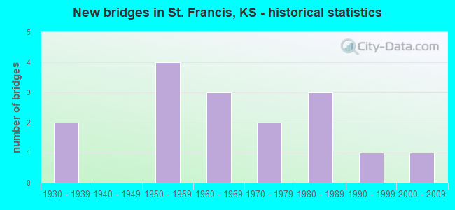
- New bridges - historical statistics
- 21930-1939
- 41950-1959
- 31960-1969
- 21970-1979
- 31980-1989
- 11990-1999
- 12000-2009
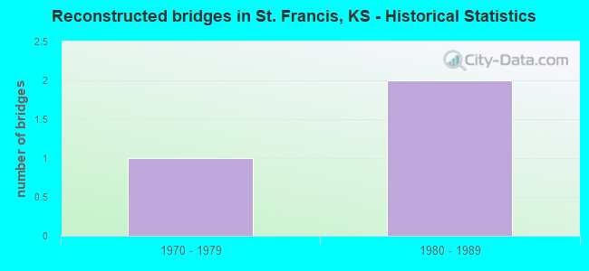
- Reconstructed bridges - Historical Statistics
- 11970-1979
- 21980-1989
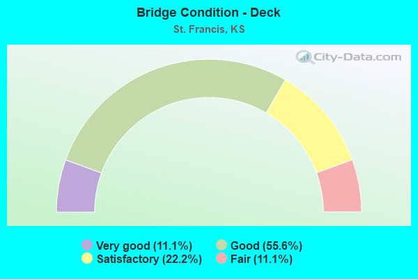
- Bridge Condition - Deck
- 11.1%Very good
- 55.6%Good
- 22.2%Satisfactory
- 11.1%Fair
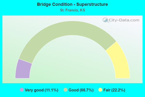
- Bridge Condition - Superstructure
- 11.1%Very good
- 66.7%Good
- 22.2%Fair
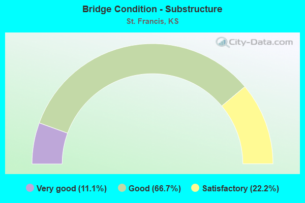
- Bridge Condition - Substructure
- 11.1%Very good
- 66.7%Good
- 22.2%Satisfactory
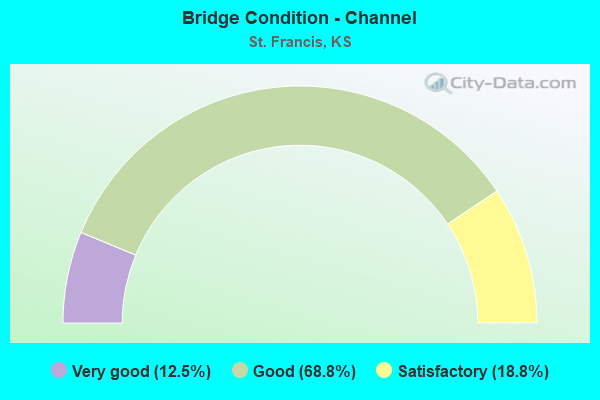
- Bridge Condition - Channel
- 12.5%Very good
- 68.8%Good
- 18.8%Satisfactory
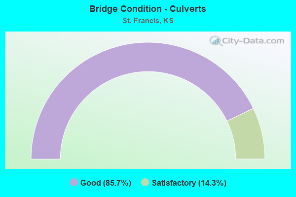
- Bridge Condition - Culverts
- 85.7%Good
- 14.3%Satisfactory
Find on map >> Show street view
Structure Number: 12001, Location: 1.3N 0.3E ST. FRANCIS (Lat: 39.789950, Lng: -101.800306), Route carried "on" structure: County highway 115, Year Built: 1962, Status: Posted for load, Structure Length: 9.46m (31.04ft), Average Daily Traffic: 395 (year 2014), Truck Traffic: 20%, Average Future Daily Traffic: 475 (year 2041), Design Load: H 15, Features Intersected: SOUTH FORK REPUBLICAN
Minimum Vertical Clearance: 30.47m (99.97ft), Kilometerpoint: 2.414, Lanes on structure: 2, Owner: County Highway Agency, Approaching Roadway Width: 8.5m (27.9ft), Material/Design: Concrete continuous, Design/Construction: Tee Beam, Number Of Spans In Main Unit: 6, Length of Maximum Span: 16.8m (55.1ft), Curb or Sidewalk Widths: Left: 0.3m (1.0ft), Right: 0.3m (1.0ft), Curb-To-Curb Width: 7.9m (25.9ft), Out-to-Out Width: 8.5m (27.9ft)
Condition: Deck: Satisfactory, Superstructure: Good, Substructure: Good, Channel: Satisfactory, Operating Rating: 15.2 metric tons, Method Used To Determine Operating Rating: Load Factor (LF), Inventory Rating: 9.1 metric tons, Method Used To Determine Inventory Rating: Load Factor (LF), Structural Evaluation: High priority of corrective action, Deck Geometry: Somewhat better than minimum adequacy, Waterway Adequacy: Equal to present desirable criteria, Approach Roadway Alignment: Equal to present desirable criteria, Bridge Posting: Required (Relationship of Operating Rating to Maximum Legal Load: 30.0 - 39.9% below), Designated Inspection Frequency: Every 24 months, Inspection Date: January 2021, Deck Structure Type: Concrete Cast-file-Place, Wearing Surface/Protective System: Wearing Surface: Monolithic Concrete
Find on map >> Show street view
Structure Number: 12002, Location: 3.0N ST. FRANCIS (Lat: 39.822753, Lng: -101.790833), Route carried "on" structure: County highway 115, Year Built: 1963, Status: Open, Structure Length: 1.07m (3.51ft), Average Daily Traffic: 255 (year 2014), Truck Traffic: 20%, Average Future Daily Traffic: 300 (year 2041), Design Load: H 15, Features Intersected: SPRING CREEK
Minimum Vertical Clearance: 30.47m (99.97ft), Kilometerpoint: 6.437, Lanes on structure: 2, Owner: County Highway Agency, Approaching Roadway Width: 8.5m (27.9ft), Material/Design: Concrete, Design/Construction: Culvert, Number Of Spans In Main Unit: 2, Length of Maximum Span: 4.9m (16.1ft)
Condition: Channel: Good, Culverts: Good, Operating Rating: 89.8 metric tons, Method Used To Determine Operating Rating: Load Factor (LF), Inventory Rating: 75.4 metric tons, Method Used To Determine Inventory Rating: Load Factor (LF), Structural Evaluation: Better than present minimum criteria, Waterway Adequacy: Better than present minimum criteria, Approach Roadway Alignment: Equal to present desirable criteria, Designated Inspection Frequency: Every 24 months, Inspection Date: August 2021, Wearing Surface/Protective System: Wearing Surface: Bituminous
Find on map >> Show street view
Structure Number: 12026, Location: 2.1S 2.6W ST. FRANCIS (Lat: 39.740639, Lng: -101.854028), Route carried "on" structure: County highway 877, Year Built: 1956, Status: Open, Structure Length: 0.79m (2.59ft), Average Daily Traffic: 290 (year 2014), Truck Traffic: 20%, Average Future Daily Traffic: 320 (year 2041), Design Load: H 15, Features Intersected: TRIB. S FORK REPUBLICAN
Minimum Vertical Clearance: 30.47m (99.97ft), Kilometerpoint: 32.187, Lanes on structure: 2, Owner: County Highway Agency, Approaching Roadway Width: 7.3m (24.0ft), Material/Design: Concrete, Design/Construction: Culvert, Number Of Spans In Main Unit: 3, Length of Maximum Span: 2.4m (7.9ft), Curb or Sidewalk Widths: Left: 0.3m (1.0ft), Right: 0.3m (1.0ft), Curb-To-Curb Width: 9.1m (29.9ft), Out-to-Out Width: 9.8m (32.2ft)
Condition: Channel: Good, Culverts: Good, Operating Rating: 29.0 metric tons, Method Used To Determine Operating Rating: Allowable Stress (AS), Inventory Rating: 20.0 metric tons, Method Used To Determine Inventory Rating: Allowable Stress (AS), Structural Evaluation: Somewhat better than minimum adequacy, Deck Geometry: Equal to present minimum criteria, Waterway Adequacy: Equal to present desirable criteria, Approach Roadway Alignment: Equal to present desirable criteria, Designated Inspection Frequency: Every 24 months, Inspection Date: January 2021, Wearing Surface/Protective System: Wearing Surface: Bituminous
Find on map >> Show street view
Structure Number: 120265, Location: 1.2S 2.0W OF ST. FRANCIS (Lat: 39.747489, Lng: -101.842500), Route carried "on" structure: County highway 877, Year Built: 1985, Status: Open, Structure Length: 1.65m (5.41ft), Average Daily Traffic: 350 (year 2014), Truck Traffic: 20%, Average Future Daily Traffic: 400 (year 2041), Design Load: H 20, Features Intersected: DRURY CREEK
Minimum Vertical Clearance: 30.47m (99.97ft), Kilometerpoint: 35.406, Lanes on structure: 2, Owner: County Highway Agency, Approaching Roadway Width: 9.1m (29.9ft), Material/Design: Concrete, Design/Construction: Culvert, Number Of Spans In Main Unit: 5, Length of Maximum Span: 3.0m (9.8ft), Curb-To-Curb Width: 9.1m (29.9ft), Out-to-Out Width: 9.8m (32.2ft)
Condition: Channel: Good, Culverts: Satisfactory, Operating Rating: 38.1 metric tons, Method Used To Determine Operating Rating: Load Factor (LF), Inventory Rating: 22.7 metric tons, Method Used To Determine Inventory Rating: Load Factor (LF), Structural Evaluation: Equal to present minimum criteria, Deck Geometry: Equal to present minimum criteria, Waterway Adequacy: Better than present minimum criteria, Approach Roadway Alignment: Equal to present desirable criteria, Designated Inspection Frequency: Every 24 months, Inspection Date: January 2021, Wearing Surface/Protective System: Wearing Surface: Bituminous
Find on map >> Show street view
Structure Number: 12033750326, Location: 3.0N 2.5W OF ST.FRANCIS (Lat: 39.814836, Lng: -101.852556), Route carried "on" structure: County highway 1224, Year Built: 1973, Status: Open, Structure Length: 1.74m (5.71ft), Average Daily Traffic: 50 (year 2014), Average Future Daily Traffic: 60 (year 2041), Features Intersected: TRIB. TO CHERRY CREEK, Facility Carried by Structure: R Road
Minimum Vertical Clearance: 30.47m (99.97ft), Kilometerpoint: 0.000, Lanes on structure: 2, Owner: County Highway Agency, Approaching Roadway Width: 7.9m (25.9ft), Skew: 4 degrees, Material/Design: Steel continuous, Design/Construction: Stringer/Multi-beam, Number Of Spans In Main Unit: 2, Length of Maximum Span: 8.2m (26.9ft), Curb or Sidewalk Widths: Left: 0.3m (1.0ft), Right: 0.3m (1.0ft), Curb-To-Curb Width: 7.9m (25.9ft), Out-to-Out Width: 8.6m (28.2ft)
Condition: Deck: Good, Superstructure: Good, Substructure: Good, Channel: Satisfactory, Operating Rating: 56.2 metric tons, Method Used To Determine Operating Rating: Load Factor (LF), Inventory Rating: 33.6 metric tons, Method Used To Determine Inventory Rating: Load Factor (LF), Structural Evaluation: Better than present minimum criteria, Deck Geometry: Equal to present minimum criteria, Waterway Adequacy: Equal to present desirable criteria, Approach Roadway Alignment: Equal to present desirable criteria, Designated Inspection Frequency: Every 24 months, Inspection Date: January 2021, Deck Structure Type: Concrete Cast-file-Place, Wearing Surface/Protective System: Wearing Surface: Monolithic Concrete
Find on map >> Show street view
Structure Number: 12034140326, Location: 3.0N 0.5W OF ST. FRANCIS (Lat: 39.814647, Lng: -101.815722), Route carried "on" structure: County highway 1224, Year Built: 1959, Status: Open, Structure Length: 1.25m (4.10ft), Average Daily Traffic: 70 (year 2014), Average Future Daily Traffic: 75 (year 2041), Features Intersected: FISH CREEK, Facility Carried by Structure: R Road
Minimum Vertical Clearance: 30.47m (99.97ft), Kilometerpoint: 0.000, Lanes on structure: 2, Owner: County Highway Agency, Approaching Roadway Width: 7.8m (25.6ft), Material/Design: Concrete, Design/Construction: Culvert, Number Of Spans In Main Unit: 2, Length of Maximum Span: 6.1m (20.0ft)
Condition: Channel: Good, Culverts: Good, Operating Rating: 40.8 metric tons, Method Used To Determine Operating Rating: Load Factor (LF), Inventory Rating: 24.5 metric tons, Method Used To Determine Inventory Rating: Load Factor (LF), Structural Evaluation: Equal to present minimum criteria, Waterway Adequacy: Equal to present desirable criteria, Approach Roadway Alignment: Equal to present desirable criteria, Designated Inspection Frequency: Every 24 months, Inspection Date: January 2021, Wearing Surface/Protective System: Wearing Surface: Gravel
Find on map >> Show street view
Structure Number: 120341503261, Location: 2.5N 0.5W OF ST FRANCIS (Lat: 39.813000, Lng: -101.814417), Route carried "on" structure: County highway , Year Built: 1985, Status: Open, Structure Length: 0.88m (2.89ft), Average Daily Traffic: 50 (year 2014), Average Future Daily Traffic: 60 (year 2041), Design Load: H 20, Features Intersected: FISH CREEK, Facility Carried by Structure: 13 Road
Minimum Vertical Clearance: 30.47m (99.97ft), Kilometerpoint: 0.000, Lanes on structure: 2, Owner: County Highway Agency, Approaching Roadway Width: 7.9m (25.9ft), Material/Design: Steel, Design/Construction: Stringer/Multi-beam, Number Of Spans In Main Unit: 1, Length of Maximum Span: 8.5m (27.9ft), Curb-To-Curb Width: 7.2m (23.6ft), Out-to-Out Width: 7.3m (24.0ft)
Condition: Deck: Good, Superstructure: Good, Substructure: Good, Channel: Satisfactory, Operating Rating: 89.8 metric tons, Method Used To Determine Operating Rating: Allowable Stress (AS), Inventory Rating: 67.1 metric tons, Method Used To Determine Inventory Rating: Allowable Stress (AS), Structural Evaluation: Better than present minimum criteria, Deck Geometry: Somewhat better than minimum adequacy, Waterway Adequacy: Better than present minimum criteria, Approach Roadway Alignment: Equal to present desirable criteria, Designated Inspection Frequency: Every 24 months, Inspection Date: January 2021, Deck Structure Type: Corrugated Steel, Wearing Surface/Protective System: Wearing Surface: Gravel
Find on map >> Show street view
Structure Number: 120341503289, Location: 0.5N 0.5W OF ST. FRANCIS (Lat: 39.787889, Lng: -101.814639), Route carried "on" structure: County highway , Year Built: 2007, Status: Open, Structure Length: 3.14m (10.30ft), Average Daily Traffic: 75 (year 2014), Average Future Daily Traffic: 90 (year 2041), Design Load: HS 20, Features Intersected: CHERRY CREEK, Facility Carried by Structure: 13.5 Road
Minimum Vertical Clearance: 30.47m (99.97ft), Kilometerpoint: 0.000, Lanes on structure: 2, Owner: County Highway Agency, Approaching Roadway Width: 7.9m (25.9ft), Skew: 3 degrees, Material/Design: Concrete continuous, Design/Construction: Slab, Number Of Spans In Main Unit: 3, Length of Maximum Span: 12.2m (40.0ft), Curb-To-Curb Width: 9.1m (29.9ft), Out-to-Out Width: 9.8m (32.2ft)
Condition: Deck: Very good, Superstructure: Very good, Substructure: Very good, Channel: Good, Operating Rating: 61.3 metric tons, Method Used To Determine Operating Rating: Load Factor (LF), Inventory Rating: 36.7 metric tons, Method Used To Determine Inventory Rating: Load Factor (LF), Structural Evaluation: Equal to present desirable criteria, Deck Geometry: Better than present minimum criteria, Waterway Adequacy: Better than present minimum criteria, Approach Roadway Alignment: Equal to present desirable criteria, Designated Inspection Frequency: Every 24 months, Inspection Date: January 2021, Deck Structure Type: Concrete Cast-file-Place, Wearing Surface/Protective System: Wearing Surface: Monolithic Concrete
Find on map >> Show street view
Structure Number: 120343103305, Location: WEST EDGE OF ST. FRANCIS (Lat: 39.778328, Lng: -101.806722), Route carried "on" structure: County highway 1218, Year Built: 1970, Status: Posted for load, Structure Length: 3.66m (12.01ft), Average Daily Traffic: 150 (year 2014), Truck Traffic: 20%, Average Future Daily Traffic: 165 (year 2041), Design Load: H 15, Features Intersected: S FORK REPUBLICAN RIVER, Facility Carried by Structure: O Road (River St)
Minimum Vertical Clearance: 30.47m (99.97ft), Kilometerpoint: 0.000, Lanes on structure: 2, Owner: County Highway Agency, Approaching Roadway Width: 7.3m (24.0ft), Material/Design: Prestressed concrete, Design/Construction: Tee Beam, Number Of Spans In Main Unit: 3, Length of Maximum Span: 12.2m (40.0ft), Curb-To-Curb Width: 7.2m (23.6ft), Out-to-Out Width: 7.3m (24.0ft)
Condition: Deck: Fair, Superstructure: Fair, Substructure: Satisfactory, Channel: Good, Operating Rating: 25.1 metric tons, Method Used To Determine Operating Rating: Load Factor (LF), Inventory Rating: 12.7 metric tons, Method Used To Determine Inventory Rating: Load Factor (LF), Structural Evaluation: Meets minimum limits, Deck Geometry: Meets minimum limits, Waterway Adequacy: Better than present minimum criteria, Approach Roadway Alignment: High priority of corrective action, Bridge Posting: Required (Relationship of Operating Rating to Maximum Legal Load: 30.0 - 39.9% below), Length Of Structure Improvement: 3.69m (12.11ft), Designated Inspection Frequency: Every 24 months, Inspection Date: January 2021, Other Special Inspection Date: November 2021, Bridge Improvement Cost: $300,000, Roadway Improvement Cost: $60,000, Total Project Cost: $450,000, Deck Structure Type: Concrete Precast Panels, Wearing Surface/Protective System: Wearing Surface: Bituminous
Find on map >> Show street view
Structure Number: 12034720338, Location: 3.0S 2.0E OF ST. FRANCIS (Lat: 39.727486, Lng: -101.765056), Route carried "on" structure: County highway , Year Built: 1960, Status: Posted for load, Structure Length: 1.01m (3.31ft), Average Daily Traffic: 15 (year 2014), Average Future Daily Traffic: 20 (year 2041), Features Intersected: WEST FORK SAND CREEK, Facility Carried by Structure: L Road
Minimum Vertical Clearance: 30.47m (99.97ft), Kilometerpoint: 0.000, Lanes on structure: 2, Owner: County Highway Agency, Approaching Roadway Width: 6.7m (22.0ft), Material/Design: Wood or Timber, Design/Construction: Stringer/Multi-beam, Number Of Spans In Main Unit: 2, Length of Maximum Span: 4.9m (16.1ft), Curb-To-Curb Width: 7.2m (23.6ft), Out-to-Out Width: 7.4m (24.3ft)
Condition: Deck: Satisfactory, Superstructure: Fair, Substructure: Satisfactory, Channel: Good, Operating Rating: 45.4 metric tons, Method Used To Determine Operating Rating: Load Factor (LF), Inventory Rating: 27.2 metric tons, Method Used To Determine Inventory Rating: Load Factor (LF), Structural Evaluation: Somewhat better than minimum adequacy, Deck Geometry: Somewhat better than minimum adequacy, Waterway Adequacy: Better than present minimum criteria, Approach Roadway Alignment: Equal to present desirable criteria, Designated Inspection Frequency: Every 24 months, Inspection Date: January 2021, Deck Structure Type: Wood or Timber, Wearing Surface/Protective System: Wearing Surface: Gravel
Find on map >> Show street view
Structure Number: 999902700120061, Location: 1.43 MI. NORTH OF US-36 (Lat: 39.787778, Lng: -101.839444), Route carried "on" structure: State highway 27, Year Built: 1951, Year Reconstructed: 1992, Status: Open, Structure Length: 5.24m (17.19ft), Average Daily Traffic: 685 (year 2020), Truck Traffic: 39%, Average Future Daily Traffic: 887 (year 2041), Design Load: H 20, Features Intersected: CHERRY CREEK
Minimum Vertical Clearance: 30.47m (99.97ft), Kilometerpoint: 34.044, Lanes on structure: 2, Base Highway Network: Yes, Owner: State Highway Agency, Approaching Roadway Width: 7.9m (25.9ft), Material/Design: Steel continuous, Design/Construction: Stringer/Multi-beam, Number Of Spans In Main Unit: 3, Length of Maximum Span: 19.8m (65.0ft), Curb-To-Curb Width: 8.5m (27.9ft), Out-to-Out Width: 9.1m (29.9ft)
Condition: Deck: Good, Superstructure: Good, Substructure: Good, Channel: Very good, Operating Rating: 58.8 metric tons, Method Used To Determine Operating Rating: Load Factor (LF), Inventory Rating: 35.2 metric tons, Method Used To Determine Inventory Rating: Load Factor (LF), Structural Evaluation: Better than present minimum criteria, Deck Geometry: Somewhat better than minimum adequacy, Waterway Adequacy: Equal to present desirable criteria, Approach Roadway Alignment: Better than present minimum criteria, Length Of Structure Improvement: 17.20m (56.43ft), Designated Inspection Frequency: Every 24 months, Inspection Date: May 2020, Wearing Surface/Protective System: Wearing Surface: Monolithic Concrete, Deck Protection: Epoxy Coated Reinforcing
Find on map >> Show street view
Structure Number: 999902700120071, Location: 2.80 MI. NORTH OF US-36 (Lat: 39.806944, Lng: -101.842500), Route carried "on" structure: State highway 27, Year Built: 1951, Status: Open, Structure Length: 0.91m (2.99ft), Average Daily Traffic: 685 (year 2020), Truck Traffic: 39%, Average Future Daily Traffic: 887 (year 2041), Design Load: H 20, Features Intersected: CHERRY CREEK DRAINAGE
Minimum Vertical Clearance: 30.47m (99.97ft), Kilometerpoint: 36.244, Lanes on structure: 2, Base Highway Network: Yes, Owner: State Highway Agency, Approaching Roadway Width: 7.3m (24.0ft), Material/Design: Concrete, Design/Construction: Culvert, Number Of Spans In Main Unit: 1, Length of Maximum Span: 9.1m (29.9ft), Curb-To-Curb Width: 7.9m (25.9ft), Out-to-Out Width: 15.9m (52.2ft)
Condition: Channel: Good, Culverts: Good, Operating Rating: 61.7 metric tons, Method Used To Determine Operating Rating: Load Factor (LF), Inventory Rating: 37.2 metric tons, Method Used To Determine Inventory Rating: Load Factor (LF), Structural Evaluation: Better than present minimum criteria, Deck Geometry: Somewhat better than minimum adequacy, Waterway Adequacy: Equal to present desirable criteria, Approach Roadway Alignment: Better than present minimum criteria, Length Of Structure Improvement: 3.66m (12.01ft), Designated Inspection Frequency: Every 24 months, Inspection Date: May 2020, Deck Structure Type: Concrete Cast-file-Place, Wearing Surface/Protective System: Wearing Surface: Bituminous
Find on map >> Show street view
Structure Number: 999903600120031, Location: 1.19MI E WJT K27 (Lat: 39.767222, Lng: -101.811389), Route carried "on" structure: US 36, Year Built: 1936, Year Reconstructed: 1984, Status: Open, Structure Length: 0.78m (2.56ft), Average Daily Traffic: 1,745 (year 2020), Truck Traffic: 26%, Average Future Daily Traffic: 1,928 (year 2041), Design Load: H 15, Features Intersected: REPUBLICAN RIVER DRN
Minimum Vertical Clearance: 30.47m (99.97ft), Kilometerpoint: 21.041, Lanes on structure: 2, Base Highway Network: Yes, Owner: State Highway Agency, Approaching Roadway Width: 7.3m (24.0ft), Material/Design: Concrete, Design/Construction: Culvert, Number Of Spans In Main Unit: 3, Length of Maximum Span: 2.4m (7.9ft), Curb-To-Curb Width: 12.2m (40.0ft), Out-to-Out Width: 23.0m (75.5ft)
Condition: Channel: Very good, Culverts: Good, Operating Rating: 32.8 metric tons, Method Used To Determine Operating Rating: Load Factor (LF), Inventory Rating: 19.7 metric tons, Method Used To Determine Inventory Rating: Load Factor (LF), Structural Evaluation: Somewhat better than minimum adequacy, Deck Geometry: Better than present minimum criteria, Waterway Adequacy: Equal to present desirable criteria, Approach Roadway Alignment: Somewhat better than minimum adequacy, Length Of Structure Improvement: 2.55m (8.37ft), Designated Inspection Frequency: Every 24 months, Inspection Date: May 2020, Deck Structure Type: Concrete Cast-file-Place, Wearing Surface/Protective System: Wearing Surface: Bituminous
Find on map >> Show street view
Structure Number: 999903600120121, Location: 0.37 MI E WJCT K27 (Lat: 39.767500, Lng: -101.824167), Route carried "on" structure: US 36, Year Built: 1936, Year Reconstructed: 1985, Status: Open, Structure Length: 23.73m (77.85ft), Average Daily Traffic: 1,745 (year 2020), Truck Traffic: 26%, Average Future Daily Traffic: 1,928 (year 2041), Design Load: HS 20, Features Intersected: REPUBLICAN RIVER
Minimum Vertical Clearance: 30.47m (99.97ft), Kilometerpoint: 19.904, Lanes on structure: 2, Base Highway Network: Yes, Owner: State Highway Agency, Approaching Roadway Width: 9.1m (29.9ft), Material/Design: Steel continuous, Design/Construction: Stringer/Multi-beam, Number Of Spans In Main Unit: 11, Length of Maximum Span: 22.1m (72.5ft), Curb-To-Curb Width: 12.2m (40.0ft), Out-to-Out Width: 12.8m (42.0ft)
Condition: Deck: Good, Superstructure: Good, Substructure: Good, Channel: Good, Operating Rating: 40.8 metric tons, Method Used To Determine Operating Rating: Load Factor (LF), Inventory Rating: 24.4 metric tons, Method Used To Determine Inventory Rating: Load Factor (LF), Structural Evaluation: Equal to present minimum criteria, Deck Geometry: Better than present minimum criteria, Waterway Adequacy: Equal to present desirable criteria, Approach Roadway Alignment: Somewhat better than minimum adequacy, Length Of Structure Improvement: 77.84m (255.38ft), Designated Inspection Frequency: Every 24 months, Inspection Date: May 2020, Wearing Surface/Protective System: Wearing Surface: Monolithic Concrete, Deck Protection: Epoxy Coated Reinforcing
Find on map >> Show street view
Structure Number: 999903600120131, Location: 0.78 MI E WJCT K27 (Lat: 39.767500, Lng: -101.818611), Route carried "on" structure: US 36, Year Built: 1985, Status: Open, Structure Length: 2.36m (7.74ft), Average Daily Traffic: 1,745 (year 2020), Truck Traffic: 26%, Average Future Daily Traffic: 1,928 (year 2041), Design Load: HS 20, Features Intersected: REPUBLICAN RIVER DRN
Minimum Vertical Clearance: 30.47m (99.97ft), Kilometerpoint: 20.419, Lanes on structure: 2, Base Highway Network: Yes, Owner: State Highway Agency, Approaching Roadway Width: 7.3m (24.0ft), Material/Design: Steel, Design/Construction: Stringer/Multi-beam, Number Of Spans In Main Unit: 1, Length of Maximum Span: 22.9m (75.1ft), Curb-To-Curb Width: 12.2m (40.0ft), Out-to-Out Width: 12.8m (42.0ft)
Condition: Deck: Good, Superstructure: Good, Substructure: Good, Channel: Good, Operating Rating: 64.4 metric tons, Method Used To Determine Operating Rating: Load Factor (LF), Inventory Rating: 38.6 metric tons, Method Used To Determine Inventory Rating: Load Factor (LF), Structural Evaluation: Better than present minimum criteria, Deck Geometry: Better than present minimum criteria, Waterway Adequacy: Equal to present desirable criteria, Approach Roadway Alignment: Better than present minimum criteria, Length Of Structure Improvement: 7.75m (25.43ft), Designated Inspection Frequency: Every 24 months, Inspection Date: May 2020, Wearing Surface/Protective System: Wearing Surface: Monolithic Concrete, Deck Protection: Epoxy Coated Reinforcing
Find on map >> Show street view
Structure Number: 999903600120141, Location: 4.58 MI E WJCT K-27 (Lat: 39.756389, Lng: -101.751111), Route carried "on" structure: US 36, Year Built: 1997, Status: Open, Structure Length: 2.34m (7.68ft), Average Daily Traffic: 2,225 (year 2020), Truck Traffic: 21%, Average Future Daily Traffic: 2,458 (year 2041), Design Load: HS 20, Features Intersected: SAND CREEK
Minimum Vertical Clearance: 30.47m (99.97ft), Kilometerpoint: 26.503, Lanes on structure: 2, Base Highway Network: Yes, Owner: State Highway Agency, Approaching Roadway Width: 8.5m (27.9ft), Material/Design: Concrete, Design/Construction: Culvert, Number Of Spans In Main Unit: 7, Length of Maximum Span: 3.0m (9.8ft), Curb-To-Curb Width: 8.5m (27.9ft), Out-to-Out Width: 26.7m (87.6ft)
Condition: Channel: Good, Culverts: Good, Operating Rating: 99.8 metric tons, Method Used To Determine Operating Rating: Load Factor (LF), Inventory Rating: 59.9 metric tons, Method Used To Determine Inventory Rating: Load Factor (LF), Structural Evaluation: Better than present minimum criteria, Deck Geometry: Meets minimum limits, Waterway Adequacy: Equal to present desirable criteria, Approach Roadway Alignment: Better than present minimum criteria, Length Of Structure Improvement: 7.67m (25.16ft), Designated Inspection Frequency: Every 24 months, Inspection Date: May 2020, Deck Structure Type: Concrete Cast-file-Place, Wearing Surface/Protective System: Wearing Surface: Bituminous