Bridge Statistics for St. Helena, California (CA)
Condition, Traffic, Stress, Structural Evaluation, Project Costs
- National Bridge Inventory (NBI) Statistics
- 12Number of bridges
- 92ft / 27.8mTotal length
- $1,004,000Total costs
- 102,085Total average daily traffic
- 7,598Total average daily truck traffic
- 140,917Total future (year 2038) average daily traffic
- National Bridge Inventory (NBI) Registered Bridges for St. Helena
- No street view available for this location
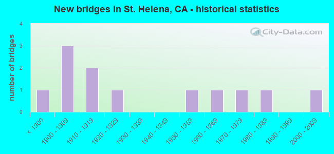
- New bridges - historical statistics
- 1Before 1900
- 31900-1909
- 21910-1919
- 11920-1929
- 11950-1959
- 11960-1969
- 11970-1979
- 11980-1989
- 12000-2009

- Reconstructed bridges - Historical Statistics
- 21930-1939
- 11940-1949
- 11950-1959
- 01960-1969
- 11970-1979
- 01980-1989
- 11990-1999


- Bridge Condition - Deck
- 71.4%Good
- 14.3%Satisfactory
- 14.3%Poor

- Bridge Condition - Superstructure
- 50.0%Good
- 8.3%Satisfactory
- 41.7%Fair

- Bridge Condition - Substructure
- 66.7%Good
- 33.3%Fair

- Bridge Condition - Channel
- 36.4%Good
- 45.5%Satisfactory
- 9.1%Fair
- 9.1%Poor
Find on map >> Show street view
Structure Number: 21 0014, Location: 04-NAP-029-16.48 (Lat: 38.365236, Lng: -122.337647), Route carried "on" structure: State highway 29, Year Built: 1970, Year Reconstructed: 1997, Status: Open, Structure Length: 2.67m (8.76ft), Average Daily Traffic: 43,000 (year 2017), Truck Traffic: 7%, Average Future Daily Traffic: 55,900 (year 2040), Design Load: HS 20, Features Intersected: DRY CREEK
Minimum Vertical Clearance: 30+ m (98+ ft), Kilometerpoint: 16.480, Lanes on structure: 4, Base Highway Network: Yes (, Subroute: 1), Owner: State Highway Agency, Approaching Roadway Width: 28.9m (94.8ft), Skew: 1 degrees, Material/Design: Concrete continuous, Design/Construction: Slab, Number Of Spans In Main Unit: 2, Length of Maximum Span: 12.8m (42.0ft), Curb-To-Curb Width: 28.9m (94.8ft), Out-to-Out Width: 29.8m (97.8ft)
Condition: Deck: Satisfactory, Superstructure: Good, Substructure: Good, Channel: Good, Operating Rating: 36.0 metric tons, Method Used To Determine Operating Rating: Load and Resistance Factor Rating (LRFR) rating reported by rating factor(RF) method using HL-93 loadings, Inventory Rating: 25.6 metric tons, Method Used To Determine Inventory Rating: Load and Resistance Factor Rating (LRFR) rating reported by rating factor(RF) method using HL-93 loadings, Structural Evaluation: Equal to present minimum criteria, Deck Geometry: Superior to present desirable criteria, Waterway Adequacy: Equal to present desirable criteria, Approach Roadway Alignment: Equal to present desirable criteria, Length Of Structure Improvement: 2.62m (8.60ft), Designated Inspection Frequency: Every 24 months, Inspection Date: April 2021, Deck Structure Type: Concrete Cast-file-Place, Wearing Surface/Protective System: Wearing Surface: Integral Concrete
Find on map >> Show street view
Structure Number: 21 0016, Location: 04-NAP-029-28.43-SHLA (Lat: 38.502661, Lng: -122.465856), Route carried "on" structure: State highway 29, Year Built: 1910, Year Reconstructed: 1975, Status: Open, Structure Length: 2.01m (6.59ft), Average Daily Traffic: 24,000 (year 2017), Truck Traffic: 7%, Average Future Daily Traffic: 31,200 (year 2040), Features Intersected: SULPHUR CREEK
Minimum Vertical Clearance: 30+ m (98+ ft), Kilometerpoint: 28.430, Lanes on structure: 2, Base Highway Network: Yes (, Subroute: 1), Owner: State Highway Agency, Approaching Roadway Width: 10.3m (33.8ft), Skew: 3 degrees, Material/Design: Masonry, Design/Construction: Arch - Thru, Number Of Spans In Main Unit: 1, Length of Maximum Span: 18.0m (59.1ft), Curb or Sidewalk Widths: Left: 2.4m (7.9ft), Right: 0.0m, Curb-To-Curb Width: 10.3m (33.8ft), Out-to-Out Width: 15.2m (49.9ft)
Condition: Deck: Good, Superstructure: Satisfactory, Substructure: Good, Channel: Good, Operating Rating: 24.6 metric tons, Method Used To Determine Operating Rating: Field evaluation and documented engineering judgment, Inventory Rating: 14.9 metric tons, Method Used To Determine Inventory Rating: Field evaluation and documented engineering judgment, Structural Evaluation: High priority of corrective action, Deck Geometry: Meets minimum limits, Waterway Adequacy: Better than present minimum criteria, Approach Roadway Alignment: Equal to present desirable criteria, Designated Inspection Frequency: Every 24 months, Inspection Date: April 2021
Find on map >> Show street view
Structure Number: 21 0017, Location: 04-NAP-029-29.29-SHLA (Lat: 38.510075, Lng: -122.478531), Route carried "on" structure: State highway 29, Year Built: 1902, Year Reconstructed: 1942, Status: Open, Structure Length: 1.07m (3.51ft), Average Daily Traffic: 20,000 (year 2017), Truck Traffic: 7%, Average Future Daily Traffic: 26,000 (year 2040), Features Intersected: YORK CREEK
Minimum Vertical Clearance: 30+ m (98+ ft), Kilometerpoint: 29.290, Lanes on structure: 2, Owner: State Highway Agency, Approaching Roadway Width: 12.2m (40.0ft), Material/Design: Masonry, Design/Construction: Arch - Thru, Number Of Spans In Main Unit: 1, Length of Maximum Span: 9.4m (30.8ft), Curb or Sidewalk Widths: Left: 1.5m (4.9ft), Right: 0.0m, Curb-To-Curb Width: 12.2m (40.0ft), Out-to-Out Width: 13.7m (44.9ft)
Condition: Deck: Good, Superstructure: Good, Substructure: Good, Channel: Fair, Operating Rating: 25.9 metric tons, Method Used To Determine Operating Rating: Field evaluation and documented engineering judgment, Inventory Rating: 15.6 metric tons, Method Used To Determine Inventory Rating: Field evaluation and documented engineering judgment, Structural Evaluation: High priority of corrective action, Deck Geometry: Somewhat better than minimum adequacy, Waterway Adequacy: Equal to present minimum criteria, Approach Roadway Alignment: Equal to present desirable criteria, Designated Inspection Frequency: Every 24 months, Inspection Date: April 2021
Find on map >> Show street view
Structure Number: 21C0002, Location: 1 MI E RT 29 WHEELER STA (Lat: 38.495181, Lng: -122.425722), Route carried "on" structure: County highway , Year Built: 1913, Status: Open, Structure Length: 2.90m (9.51ft), Average Daily Traffic: 2,600 (year 2005), Truck Traffic: 10%, Average Future Daily Traffic: 3,979 (year 2038), Features Intersected: NAPA RIVER, Facility Carried by Structure: ZINFANDEL LANE
Minimum Vertical Clearance: 30+ m (98+ ft), Kilometerpoint: 0.000, Lanes on structure: 2, Base Highway Network: Yes, Owner: County Highway Agency, Approaching Roadway Width: 7.3m (24.0ft), Skew: 2 degrees, Material/Design: Masonry, Design/Construction: Arch - Deck, Number Of Spans In Main Unit: 2, Length of Maximum Span: 12.2m (40.0ft), Curb-To-Curb Width: 6.1m (20.0ft), Out-to-Out Width: 7.3m (24.0ft)
Condition: Superstructure: Fair, Substructure: Fair, Channel: Poor, Operating Rating: 27.2 metric tons, Method Used To Determine Operating Rating: Field evaluation and documented engineering judgment, Inventory Rating: 16.2 metric tons, Method Used To Determine Inventory Rating: Field evaluation and documented engineering judgment, Structural Evaluation: Meets minimum limits, Deck Geometry: High priority of replacement, Waterway Adequacy: Equal to present desirable criteria, Approach Roadway Alignment: Equal to present minimum criteria, Designated Inspection Frequency: Every 24 months, Inspection Date: May 2021
Find on map >> Show street view
Structure Number: 21C0023, Location: 0.5 MI NE SR 29 (Lat: 38.522764, Lng: -122.482817), Route carried "on" structure: County highway , Year Built: 1966, Status: Open, Structure Length: 5.36m (17.59ft), Average Daily Traffic: 3,115 (year 2012), Truck Traffic: 10%, Average Future Daily Traffic: 5,090 (year 2040), Design Load: HS 20, Features Intersected: NAPA RIVER, Facility Carried by Structure: DEER PARK ROAD
Minimum Vertical Clearance: 30+ m (98+ ft), Kilometerpoint: 0.000, Lanes on structure: 2, Owner: County Highway Agency, Approaching Roadway Width: 11.9m (39.0ft), Skew: 2 degrees, Material/Design: Concrete continuous, Design/Construction: Tee Beam, Number Of Spans In Main Unit: 3, Length of Maximum Span: 21.3m (69.9ft), Curb-To-Curb Width: 11.0m (36.1ft), Out-to-Out Width: 11.2m (36.7ft)
Condition: Deck: Poor, Superstructure: Good, Substructure: Good, Channel: Satisfactory, Operating Rating: 33.0 metric tons, Method Used To Determine Operating Rating: Load and Resistance Factor Rating (LRFR) rating reported by rating factor(RF) method using HL-93 loadings, Inventory Rating: 23.3 metric tons, Method Used To Determine Inventory Rating: Load and Resistance Factor Rating (LRFR) rating reported by rating factor(RF) method using HL-93 loadings, Structural Evaluation: Equal to present minimum criteria, Deck Geometry: Somewhat better than minimum adequacy, Waterway Adequacy: Equal to present desirable criteria, Approach Roadway Alignment: Equal to present desirable criteria, Length Of Structure Improvement: 5.36m (17.59ft), Designated Inspection Frequency: Every 24 months, Inspection Date: May 2020, Bridge Improvement Cost: $598,000, Roadway Improvement Cost: $119,000, Total Project Cost: $1,004,000 ( Estimate for 2017), Deck Structure Type: Concrete Cast-file-Place
Find on map >> Show street view
Structure Number: 21C0077, Location: 4.1 MI E SILVERADO TRAIL (Lat: 38.504433, Lng: -122.393778), Route carried "on" structure: County highway , Year Built: 1920, Year Reconstructed: 1946, Status: Open, Structure Length: 1.13m (3.71ft), Average Daily Traffic: 740 (year 2005), Truck Traffic: 10%, Average Future Daily Traffic: 1,220 (year 2038), Features Intersected: CONN CREEK, Facility Carried by Structure: CONN VALLEY RD
Minimum Vertical Clearance: 30+ m (98+ ft), Kilometerpoint: 0.000, Lanes on structure: 2, Owner: County Highway Agency, Approaching Roadway Width: 4.3m (14.1ft), Skew: 1 degrees, Material/Design: Concrete, Design/Construction: Tee Beam, Number Of Spans In Main Unit: 1, Length of Maximum Span: 11.0m (36.1ft), Curb or Sidewalk Widths: Left: 0.3m (1.0ft), Right: 0.3m (1.0ft), Curb-To-Curb Width: 5.5m (18.0ft), Out-to-Out Width: 6.1m (20.0ft)
Condition: Deck: Good, Superstructure: Good, Substructure: Fair, Channel: Satisfactory, Operating Rating: 25.9 metric tons, Method Used To Determine Operating Rating: Load Factor (LF), Inventory Rating: 15.6 metric tons, Method Used To Determine Inventory Rating: Load Factor (LF), Structural Evaluation: Meets minimum limits, Deck Geometry: High priority of replacement, Waterway Adequacy: Better than present minimum criteria, Approach Roadway Alignment: Equal to present minimum criteria, Designated Inspection Frequency: Every 24 months, Inspection Date: May 2021, Deck Structure Type: Concrete Cast-file-Place, Wearing Surface/Protective System: Wearing Surface: Bituminous
Find on map >> Show street view
Structure Number: 21C0101, Location: 0.1 MI W/O SR 128 (Lat: 38.471156, Lng: -122.228297), Route carried "on" structure: County highway , Year Built: 1955, Status: Open, Structure Length: 0.94m (3.08ft), Average Daily Traffic: 100 (year 2012), Truck Traffic: 10%, Average Future Daily Traffic: 320 (year 2040), Features Intersected: CAPELL CREEK, Facility Carried by Structure: CAPELL CROSS RD
Minimum Vertical Clearance: 30+ m (98+ ft), Kilometerpoint: 0.000, Lanes on structure: 2, Owner: County Highway Agency, Approaching Roadway Width: 8.0m (26.2ft), Material/Design: Steel, Design/Construction: Arch - Deck, Number Of Spans In Main Unit: 1, Length of Maximum Span: 9.1m (29.9ft), Curb-To-Curb Width: 7.4m (24.3ft), Out-to-Out Width: 8.0m (26.2ft)
Condition: Superstructure: Good, Substructure: Good, Channel: Satisfactory, Operating Rating: 40.5 metric tons, Method Used To Determine Operating Rating: Field evaluation and documented engineering judgment, Inventory Rating: 24.3 metric tons, Method Used To Determine Inventory Rating: Field evaluation and documented engineering judgment, Structural Evaluation: Equal to present minimum criteria, Deck Geometry: Equal to present minimum criteria, Waterway Adequacy: Equal to present desirable criteria, Approach Roadway Alignment: Somewhat better than minimum adequacy, Designated Inspection Frequency: Every 24 months, Inspection Date: May 2020
Find on map >> Show street view
Structure Number: 21C0109, Location: SILVERADO TRAIL (Lat: 38.511136, Lng: -122.455861), Route carried "on" structure: City street , Year Built: 1894, Status: Open, Structure Length: 5.39m (17.68ft), Average Daily Traffic: 2,790 (year 2005), Truck Traffic: 10%, Average Future Daily Traffic: 4,356 (year 2041), Features Intersected: NAPA RIVER, Facility Carried by Structure: POPE ST
Minimum Vertical Clearance: 30+ m (98+ ft), Kilometerpoint: 0.000, Lanes on structure: 2, Owner: City or Municipal Highway Agency, Approaching Roadway Width: 6.4m (21.0ft), Material/Design: Masonry, Design/Construction: Arch - Deck, Number Of Spans In Main Unit: 3, Length of Maximum Span: 15.2m (49.9ft), Curb-To-Curb Width: 5.6m (18.4ft), Out-to-Out Width: 6.6m (21.7ft)
Condition: Superstructure: Fair, Substructure: Good, Channel: Good, Operating Rating: 27.2 metric tons, Method Used To Determine Operating Rating: Field evaluation and documented engineering judgment, Inventory Rating: 16.2 metric tons, Method Used To Determine Inventory Rating: Field evaluation and documented engineering judgment, Structural Evaluation: Meets minimum limits, Deck Geometry: High priority of replacement, Waterway Adequacy: Equal to present desirable criteria, Approach Roadway Alignment: High priority of replacement, Designated Inspection Frequency: Every 24 months, Inspection Date: August 2021
Find on map >> Show street view
Structure Number: 21C011, Location: 0.25 MI N/W SR 29 (Lat: 38.505000, Lng: -122.463858), Route carried "on" structure: City street , Year Built: 1908, Year Reconstructed: 1950, Status: Open, Structure Length: 1.83m (6.00ft), Average Daily Traffic: 2,790 (year 2005), Truck Traffic: 10%, Average Future Daily Traffic: 4,356 (year 2041), Features Intersected: SULPHUR CREEK, Facility Carried by Structure: POPE ST
Minimum Vertical Clearance: 30+ m (98+ ft), Kilometerpoint: 0.000, Lanes on structure: 2, Owner: City or Municipal Highway Agency, Approaching Roadway Width: 11.0m (36.1ft), Material/Design: Masonry, Design/Construction: Arch - Deck, Number Of Spans In Main Unit: 1, Length of Maximum Span: 14.3m (46.9ft), Curb or Sidewalk Widths: Left: 0.0m, Right: 1.3m (4.3ft), Curb-To-Curb Width: 7.3m (24.0ft), Out-to-Out Width: 9.8m (32.2ft)
Condition: Deck: Good, Superstructure: Fair, Substructure: Good, Channel: Satisfactory, Operating Rating: 27.2 metric tons, Method Used To Determine Operating Rating: Field evaluation and documented engineering judgment, Inventory Rating: 16.2 metric tons, Method Used To Determine Inventory Rating: Field evaluation and documented engineering judgment, Structural Evaluation: Meets minimum limits, Deck Geometry: High priority of replacement, Waterway Adequacy: Equal to present desirable criteria, Approach Roadway Alignment: Somewhat better than minimum adequacy, Designated Inspection Frequency: Every 24 months, Inspection Date: August 2021, Deck Structure Type: Concrete Cast-file-Place, Wearing Surface/Protective System: Wearing Surface: Bituminous
Find on map >> Show street view
Structure Number: 21C0112, Location: 0.1 MI N GRAYSON AVE (Lat: 38.494469, Lng: -122.469981), Route carried "on" structure: City street , Year Built: 1981, Status: Open, Structure Length: 1.65m (5.41ft), Average Daily Traffic: 1,000 (year 1982), Truck Traffic: 10%, Average Future Daily Traffic: 2,726 (year 2041), Features Intersected: SULPHUR CREEK, Facility Carried by Structure: VALLEYVIEW ST
Minimum Vertical Clearance: 30+ m (98+ ft), Kilometerpoint: 0.000, Lanes on structure: 2, Owner: City or Municipal Highway Agency, Approaching Roadway Width: 10.4m (34.1ft), Material/Design: Aluminum, Iron, Design/Construction: Arch - Deck, Number Of Spans In Main Unit: 3, Length of Maximum Span: 5.5m (18.0ft), Curb or Sidewalk Widths: Left: 1.1m (3.6ft), Right: 1.1m (3.6ft), Curb-To-Curb Width: 10.4m (34.1ft), Out-to-Out Width: 12.6m (41.3ft)
Condition: Superstructure: Good, Substructure: Good, Channel: Good, Operating Rating: 54.1 metric tons, Method Used To Determine Operating Rating: Field evaluation and documented engineering judgment, Inventory Rating: 32.4 metric tons, Method Used To Determine Inventory Rating: Field evaluation and documented engineering judgment, Structural Evaluation: Better than present minimum criteria, Deck Geometry: Equal to present minimum criteria, Waterway Adequacy: Better than present minimum criteria, Approach Roadway Alignment: Equal to present minimum criteria, Designated Inspection Frequency: Every 24 months, Inspection Date: August 2021
Find on map >> Show street view
Structure Number: 21C0113, Location: 0.3 MI WEST OF MADRONA ST (Lat: 38.507256, Lng: -122.492103), Route carried "on" structure: City street , Year Built: 1903, Year Reconstructed: 1935, Status: Open, Structure Length: 1.01m (3.31ft), Average Daily Traffic: 1,500 (year 2012), Truck Traffic: 10%, Average Future Daily Traffic: 4,750 (year 2040), Features Intersected: YORK CREEK, Facility Carried by Structure: SPRING MOUNTAIN RD
Minimum Vertical Clearance: 30+ m (98+ ft), Kilometerpoint: 0.000, Lanes on structure: 2, Owner: City or Municipal Highway Agency, Approaching Roadway Width: 7.3m (24.0ft), Material/Design: Masonry, Design/Construction: Arch - Deck, Number Of Spans In Main Unit: 1, Length of Maximum Span: 8.8m (28.9ft), Curb-To-Curb Width: 8.2m (26.9ft), Out-to-Out Width: 9.3m (30.5ft)
Condition: Superstructure: Fair, Substructure: Fair, Channel: Satisfactory, Operating Rating: 24.3 metric tons, Method Used To Determine Operating Rating: Field evaluation and documented engineering judgment, Inventory Rating: 16.2 metric tons, Method Used To Determine Inventory Rating: Field evaluation and documented engineering judgment, Structural Evaluation: Meets minimum limits, Deck Geometry: Meets minimum limits, Waterway Adequacy: Better than present minimum criteria, Approach Roadway Alignment: Somewhat better than minimum adequacy, Designated Inspection Frequency: Every 24 months, Inspection Date: May 2020
Find on map >> Show street view
Structure Number: 21C0131, Location: 3 MI WEST OF MADRONA AVE (Lat: 38.516325, Lng: -122.517256), Route carried "on" structure: County highway , Year Built: 2009, Status: Open, Structure Length: 1.86m (6.10ft), Average Daily Traffic: 450 (year 2006), Truck Traffic: 10%, Average Future Daily Traffic: 1,020 (year 2040), Features Intersected: HILLSIDE, Facility Carried by Structure: SPRING MOUNTAIN RD
Minimum Vertical Clearance: 30+ m (98+ ft), Kilometerpoint: 0.000, Lanes on structure: 2, Owner: County Highway Agency, Approaching Roadway Width: 8.5m (27.9ft), Material/Design: Steel, Design/Construction: Stringer/Multi-beam, Number Of Spans In Main Unit: 4, Length of Maximum Span: 4.6m (15.1ft), Curb or Sidewalk Widths: Left: 0.0m, Right: 0.3m (1.0ft), Curb-To-Curb Width: 8.5m (27.9ft), Out-to-Out Width: 3.3m (10.8ft)
Condition: Deck: Good, Superstructure: Fair, Substructure: Fair, Operating Rating: 37.9 metric tons, Method Used To Determine Operating Rating: Load Factor (LF), Inventory Rating: 22.7 metric tons, Method Used To Determine Inventory Rating: Load Factor (LF), Structural Evaluation: Somewhat better than minimum adequacy, Deck Geometry: Somewhat better than minimum adequacy, Approach Roadway Alignment: Equal to present desirable criteria, Designated Inspection Frequency: Every 24 months, Critical Feature Inspection Frequency: Every 24 months, Inspection Date: May 2020, Critical Feature Inspection Date: May 2020, Deck Structure Type: Corrugated Steel, Wearing Surface/Protective System: Wearing Surface: Bituminous