Bridge Statistics for St. Johns, Michigan (MI)
Condition, Traffic, Stress, Structural Evaluation, Project Costs
- National Bridge Inventory (NBI) Statistics
- 36Number of bridges
- 249ft / 75.7mTotal length
- $445,000Total costs
- 271,194Total average daily traffic
- 19,495Total average daily truck traffic
- National Bridge Inventory (NBI) Registered Bridges for St. Johns
- No street view available for this location
- New bridges - historical statistics
- 11910-1919
- 41920-1929
- 21940-1949
- 11950-1959
- 21980-1989
- 201990-1999
- 32000-2009
- 32010-2019
- Reconstructed bridges - Historical Statistics
- 11940-1949
- 01950-1959
- 01960-1969
- 31970-1979
- 21980-1989
- Bridge Condition - Deck
- 4.8%Very good
- 61.9%Good
- 23.8%Satisfactory
- 9.5%Fair
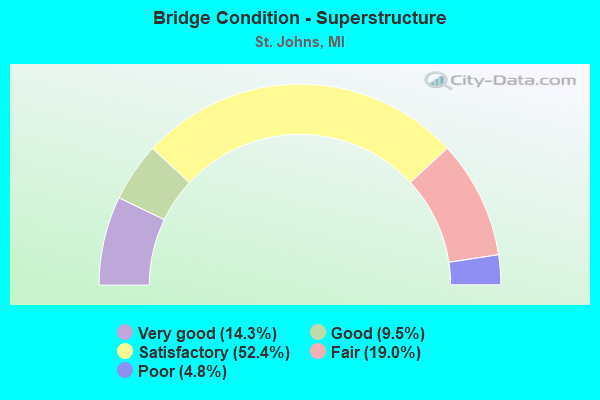
- Bridge Condition - Superstructure
- 14.3%Very good
- 9.5%Good
- 52.4%Satisfactory
- 19.0%Fair
- 4.8%Poor
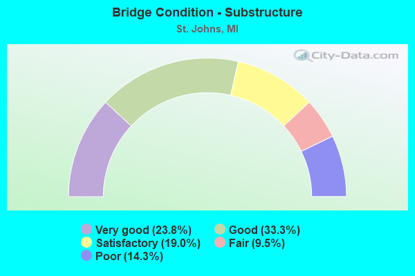
- Bridge Condition - Substructure
- 23.8%Very good
- 33.3%Good
- 19.0%Satisfactory
- 9.5%Fair
- 14.3%Poor
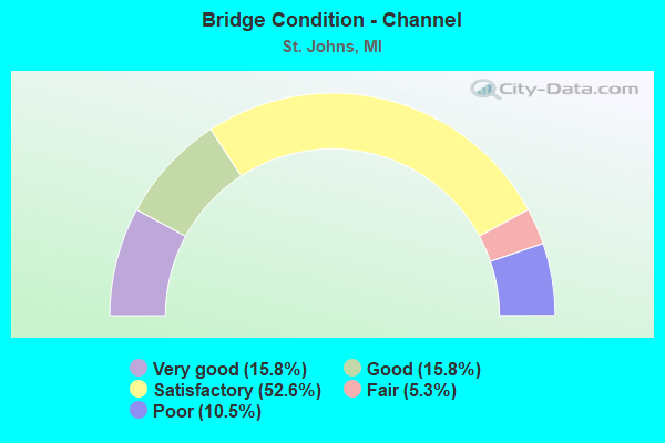
- Bridge Condition - Channel
- 15.8%Very good
- 15.8%Good
- 52.6%Satisfactory
- 5.3%Fair
- 10.5%Poor
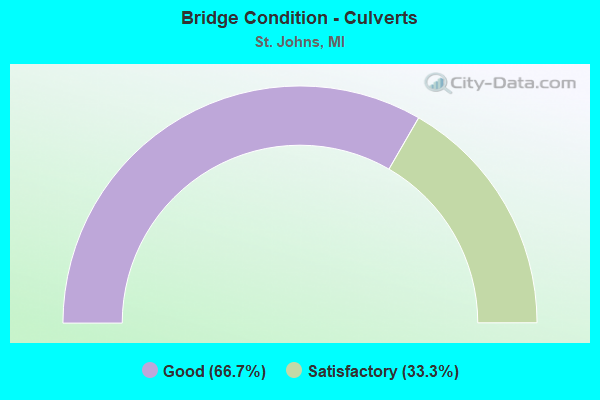
- Bridge Condition - Culverts
- 66.7%Good
- 33.3%Satisfactory
Find on map >> Show street view
Structure Number: 181, Location: EAST OF 22ND STREET (Lat: 42.674922, Lng: -85.758586), Route carried "on" structure: County highway 366, Year Built: 2009, Status: Open, Structure Length: 2.41m (7.91ft), Average Daily Traffic: 1,223 (year 2007), Truck Traffic: 7%, Average Future Daily Traffic: 2,210 (year 2027), Design Load: HL 93, Features Intersected: RABBIT RIVER, Facility Carried by Structure: 135TH AVE
Minimum Vertical Clearance: 30.48m (100.00ft), Kilometerpoint: 2.599, Lanes on structure: 2, Owner: County Highway Agency, Approaching Roadway Width: 12.2m (40.0ft), Skew: 2 degrees, Material/Design: Prestressed concrete, Design/Construction: Box Beam or Girders - Single/Spread, Number Of Spans In Main Unit: 1, Length of Maximum Span: 22.9m (75.1ft), Curb-To-Curb Width: 12.2m (40.0ft), Out-to-Out Width: 13.0m (42.7ft)
Condition: Deck: Good, Superstructure: Good, Substructure: Very good, Channel: Good, Operating Rating: 79.4 metric tons, Method Used To Determine Operating Rating: Load and Resistance Factor Rating (LRFR) rating reported by rating factor(RF) method using HL-93 loadings, Inventory Rating: 45.7 metric tons, Method Used To Determine Inventory Rating: Load and Resistance Factor Rating (LRFR) rating reported by rating factor(RF) method using HL-93 loadings, Structural Evaluation: Better than present minimum criteria, Deck Geometry: Better than present minimum criteria, Waterway Adequacy: Equal to present desirable criteria, Approach Roadway Alignment: Equal to present desirable criteria, Designated Inspection Frequency: Every 24 months, Inspection Date: October 2021, Deck Structure Type: Concrete Cast-file-Place, Wearing Surface/Protective System: Wearing Surface: Monolithic Concrete, Deck Protection: Epoxy Coated Reinforcing
Find on map >> Show street view
Structure Number: 1797, Location: 1.3 MI S OF ST JOHNS (Lat: 42.968261, Lng: -84.542614), Route carried "on" structure: Business US 127, Year Built: 1940, Year Reconstructed: 1949, Status: Open, Structure Length: 0.91m (2.99ft), Average Daily Traffic: 5,643 (year 2007), Truck Traffic: 4%, Average Future Daily Traffic: 5,788 (year 2018), Design Load: H 20, Features Intersected: SPAULDING DRAIN
Minimum Vertical Clearance: 30.48m (100.00ft), Kilometerpoint: 22.057, Lanes on structure: 2, Base Highway Network: Yes (Inventory Route: 20, Subroute: 3), Owner: State Highway Agency, Approaching Roadway Width: 27.4m (89.9ft), Skew: 20 degrees, Material/Design: Steel, Design/Construction: Stringer/Multi-beam, Number Of Spans In Main Unit: 1, Length of Maximum Span: 9.1m (29.9ft), Curb or Sidewalk Widths: Left: 0.0m, Right: 0.4m (1.3ft), Curb-To-Curb Width: 10.6m (34.8ft), Out-to-Out Width: 27.4m (89.9ft)
Condition: Deck: Satisfactory, Superstructure: Satisfactory, Substructure: Satisfactory, Channel: Satisfactory, Operating Rating: 54.1 metric tons, Method Used To Determine Operating Rating: Load Factor (LF) rating reported by rating factor (RF) method using MS18 loading, Inventory Rating: 32.4 metric tons, Method Used To Determine Inventory Rating: Load Factor (LF) rating reported by rating factor (RF) method using MS18 loading, Structural Evaluation: Equal to present minimum criteria, Deck Geometry: Somewhat better than minimum adequacy, Waterway Adequacy: Equal to present desirable criteria, Approach Roadway Alignment: Equal to present desirable criteria, Length Of Structure Improvement: 0.91m (2.99ft), Designated Inspection Frequency: Every 24 months, Inspection Date: August 2021, Bridge Improvement Cost: $9,000, Roadway Improvement Cost: $4,000, Total Project Cost: $45,000, Deck Structure Type: Concrete Cast-file-Place, Wearing Surface/Protective System: Wearing Surface: Bituminous
Find on map >> Show street view
Structure Number: 1798, Location: 1.3 MI S OF ST JOHNS (Lat: 42.968231, Lng: -84.542822), Route carried "on" structure: Business US 127, Year Built: 1949, Status: Open, Structure Length: 0.91m (2.99ft), Average Daily Traffic: 5,643 (year 2007), Truck Traffic: 4%, Average Future Daily Traffic: 5,788 (year 2018), Design Load: H 20, Features Intersected: SPAULDING DRAIN
Minimum Vertical Clearance: 30.48m (100.00ft), Kilometerpoint: 4.355, Lanes on structure: 2, Base Highway Network: Yes (Inventory Route: 319, Subroute: 11), Owner: State Highway Agency, Approaching Roadway Width: 27.4m (89.9ft), Material/Design: Steel, Design/Construction: Stringer/Multi-beam, Number Of Spans In Main Unit: 1, Length of Maximum Span: 9.1m (29.9ft), Curb or Sidewalk Widths: Left: 0.4m (1.3ft), Right: 0.0m, Curb-To-Curb Width: 10.6m (34.8ft), Out-to-Out Width: 13.7m (44.9ft)
Condition: Deck: Satisfactory, Superstructure: Satisfactory, Substructure: Satisfactory, Channel: Satisfactory, Operating Rating: 77.8 metric tons, Method Used To Determine Operating Rating: Load Factor (LF) rating reported by rating factor (RF) method using MS18 loading, Inventory Rating: 41.5 metric tons, Method Used To Determine Inventory Rating: Load Factor (LF) rating reported by rating factor (RF) method using MS18 loading, Structural Evaluation: Equal to present minimum criteria, Deck Geometry: Somewhat better than minimum adequacy, Waterway Adequacy: Equal to present desirable criteria, Approach Roadway Alignment: Equal to present desirable criteria, Designated Inspection Frequency: Every 24 months, Inspection Date: August 2021, Deck Structure Type: Concrete Cast-file-Place, Wearing Surface/Protective System: Wearing Surface: Monolithic Concrete
Find on map >> Show street view
Structure Number: 1802, Location: 2.2 MI N OF ST JOHNS (Lat: 43.045442, Lng: -84.563872), Route carried "on" structure: US 127, Year Built: 1957, Status: Open, Structure Length: 0.87m (2.85ft), Average Daily Traffic: 11,851 (year 2007), Truck Traffic: 7%, Average Future Daily Traffic: 16,437 (year 2018), Design Load: HS 20, Features Intersected: HAYWORTH COUNTY DRAIN
Minimum Vertical Clearance: 30.48m (100.00ft), Kilometerpoint: 0.636, Lanes on structure: 2, Base Highway Network: Yes (Inventory Route: 319, Subroute: 62), Owner: State Highway Agency, Approaching Roadway Width: 12.8m (42.0ft), Skew: 10 degrees, Material/Design: Concrete, Design/Construction: Tee Beam, Number Of Spans In Main Unit: 1, Length of Maximum Span: 7.7m (25.3ft), Curb or Sidewalk Widths: Left: 0.4m (1.3ft), Right: 0.4m (1.3ft), Curb-To-Curb Width: 12.8m (42.0ft), Out-to-Out Width: 13.8m (45.3ft)
Condition: Deck: Fair, Superstructure: Fair, Substructure: Satisfactory, Channel: Good, Operating Rating: 61.9 metric tons, Method Used To Determine Operating Rating: Load Factor (LF) rating reported by rating factor (RF) method using MS18 loading, Inventory Rating: 37.3 metric tons, Method Used To Determine Inventory Rating: Load Factor (LF) rating reported by rating factor (RF) method using MS18 loading, Structural Evaluation: Somewhat better than minimum adequacy, Deck Geometry: Equal to present desirable criteria, Waterway Adequacy: Equal to present desirable criteria, Approach Roadway Alignment: Equal to present desirable criteria, Designated Inspection Frequency: Every 24 months, Inspection Date: June 2020, Deck Structure Type: Concrete Cast-file-Place, Wearing Surface/Protective System: Wearing Surface: Latex Concrete
Find on map >> Show street view
Structure Number: 181, Location: IN ST JOHNS (Lat: 43.004964, Lng: -84.550964), Route carried "on" structure: Business US 127, Year Built: 2008, Status: Open, Structure Length: 0.79m (2.59ft), Average Daily Traffic: 9,216 (year 2007), Truck Traffic: 3%, Average Future Daily Traffic: 11,490 (year 2018), Design Load: HS 20, Features Intersected: FRED MEIJER STATE TRAIL
Minimum Vertical Clearance: 30.48m (100.00ft), Kilometerpoint: 26.352, Lanes on structure: 3, Base Highway Network: Yes (Inventory Route: 20, Subroute: 3), Owner: State Highway Agency, Approaching Roadway Width: 13.4m (44.0ft), Material/Design: Concrete, Design/Construction: Culvert, Number Of Spans In Main Unit: 1, Length of Maximum Span: 7.3m (24.0ft), Out-to-Out Width: 19.5m (64.0ft)
Condition: Culverts: Good, Operating Rating: 94.6 metric tons, Method Used To Determine Operating Rating: Load Factor (LF) rating reported by rating factor (RF) method using MS18 loading, Inventory Rating: 56.7 metric tons, Method Used To Determine Inventory Rating: Load Factor (LF) rating reported by rating factor (RF) method using MS18 loading, Structural Evaluation: Better than present minimum criteria, Approach Roadway Alignment: Equal to present minimum criteria, Designated Inspection Frequency: Every 24 months, Inspection Date: August 2021, Wearing Surface/Protective System: Wearing Surface: Bituminous
Find on map >> Show street view
Structure Number: 183, Location: 1.6 MI E OF US-127 BR (Lat: 43.001364, Lng: -84.518578), Route carried "on" structure: US 127, Year Built: 1993, Status: Open, Structure Length: 3.93m (12.89ft), Average Daily Traffic: 10,100 (year 2020), Truck Traffic: 8%, Average Future Daily Traffic: 11,163 (year 2040), Design Load: HS 25 or greater, Features Intersected: M-21
Minimum Vertical Clearance: 30.48m (100.00ft), Kilometerpoint: 8.079, Lanes on structure: 2, Lanes under structure: 5, Base Highway Network: Yes, Owner: State Highway Agency, Approaching Roadway Width: 13.4m (44.0ft), Material/Design: Prestressed concrete, Design/Construction: Stringer/Multi-beam, Number Of Spans In Main Unit: 1, Length of Maximum Span: 38.1m (125.0ft), Curb-To-Curb Width: 13.4m (44.0ft), Out-to-Out Width: 14.4m (47.2ft)
Condition: Deck: Good, Superstructure: Satisfactory, Substructure: Good, Operating Rating: 94.3 metric tons, Method Used To Determine Operating Rating: Load Factor (LF) rating reported by rating factor (RF) method using MS18 loading, Inventory Rating: 36.0 metric tons, Method Used To Determine Inventory Rating: Load Factor (LF) rating reported by rating factor (RF) method using MS18 loading, Structural Evaluation: Equal to present minimum criteria, Deck Geometry: Superior to present desirable criteria, Underclear: Better than present minimum criteria, Approach Roadway Alignment: Equal to present desirable criteria, Designated Inspection Frequency: Every 24 months, Inspection Date: May 2020, Deck Structure Type: Concrete Cast-file-Place, Wearing Surface/Protective System: Wearing Surface: Epoxy Overlay, Deck Protection: Epoxy Coated Reinforcing
Find on map >> Show street view
Structure Number: 184, Location: 0.5 MI N OF M-21 (Lat: 43.005053, Lng: -84.518156), Route carried "on" structure: US 127, Year Built: 1993, Status: Open, Structure Length: 3.75m (12.30ft), Average Daily Traffic: 1,000 (year 1993), Truck Traffic: 3%, Average Future Daily Traffic: 1,000 (year 2010), Design Load: HS 25 or greater, Features Intersected: FRED MEIJER STATE TRAIL
Minimum Vertical Clearance: 30.48m (100.00ft), Kilometerpoint: 0.476, Lanes on structure: 1, Base Highway Network: Yes (Inventory Route: 319, Subroute: 65), Owner: State Highway Agency, Approaching Roadway Width: 9.4m (30.8ft), Skew: 2 degrees, Material/Design: Prestressed concrete, Design/Construction: Stringer/Multi-beam, Number Of Spans In Main Unit: 3, Length of Maximum Span: 13.7m (44.9ft), Curb-To-Curb Width: 8.5m (27.9ft), Out-to-Out Width: 9.5m (31.2ft)
Condition: Deck: Good, Superstructure: Satisfactory, Substructure: Satisfactory, Operating Rating: 60.6 metric tons, Method Used To Determine Operating Rating: Load Factor (LF) rating reported by rating factor (RF) method using MS18 loading, Inventory Rating: 36.3 metric tons, Method Used To Determine Inventory Rating: Load Factor (LF) rating reported by rating factor (RF) method using MS18 loading, Structural Evaluation: Equal to present minimum criteria, Deck Geometry: Somewhat better than minimum adequacy, Approach Roadway Alignment: Equal to present desirable criteria, Designated Inspection Frequency: Every 24 months, Inspection Date: August 2021, Deck Structure Type: Concrete Cast-file-Place, Wearing Surface/Protective System: Wearing Surface: Epoxy Overlay, Deck Protection: Epoxy Coated Reinforcing
Find on map >> Show street view
Structure Number: 1843, Location: 1.0 N OF ST JOHNS (Lat: 43.029375, Lng: -84.561881), Route carried "on" structure: Business US 127, Year Built: 1994, Status: Open, Structure Length: 11.40m (37.40ft), Average Daily Traffic: 7,954 (year 2007), Truck Traffic: 4%, Average Future Daily Traffic: 9,244 (year 2018), Design Load: HS 25 or greater, Features Intersected: US-127
Minimum Vertical Clearance: 30.48m (100.00ft), Kilometerpoint: 29.428, Lanes on structure: 2, Lanes under structure: 4, Base Highway Network: Yes (Inventory Route: 20, Subroute: 3), Owner: State Highway Agency, Approaching Roadway Width: 13.4m (44.0ft), Skew: 4 degrees, Material/Design: Prestressed concrete, Design/Construction: Stringer/Multi-beam, Number Of Spans In Main Unit: 5, Length of Maximum Span: 31.7m (104.0ft), Curb-To-Curb Width: 13.4m (44.0ft), Out-to-Out Width: 14.4m (47.2ft)
Condition: Deck: Good, Superstructure: Fair, Substructure: Good, Operating Rating: 55.5 metric tons, Method Used To Determine Operating Rating: Load Factor (LF), Inventory Rating: 37.6 metric tons, Method Used To Determine Inventory Rating: Load Factor (LF), Structural Evaluation: Somewhat better than minimum adequacy, Deck Geometry: Equal to present minimum criteria, Underclear: Better than present minimum criteria, Approach Roadway Alignment: Equal to present desirable criteria, Designated Inspection Frequency: Every 24 months, Inspection Date: June 2020, Deck Structure Type: Concrete Cast-file-Place, Wearing Surface/Protective System: Wearing Surface: Monolithic Concrete, Deck Protection: Epoxy Coated Reinforcing
Find on map >> Show street view
Structure Number: 1887, Location: 1.1 MI E OF LOWELL RD (Lat: 43.001561, Lng: -84.619342), Route carried "on" structure: State highway 21, Year Built: 2005, Status: Open, Structure Length: 0.66m (2.17ft), Average Daily Traffic: 4,192 (year 2007), Truck Traffic: 8%, Average Future Daily Traffic: 5,120 (year 2018), Design Load: HS 25 or greater, Features Intersected: S FORK OF HAYWORTH CREEK
Minimum Vertical Clearance: 30.48m (100.00ft), Kilometerpoint: 17.779, Lanes on structure: 2, Base Highway Network: Yes (Inventory Route: 20, Subroute: 9), Owner: State Highway Agency, Approaching Roadway Width: 13.4m (44.0ft), Material/Design: Concrete, Design/Construction: Culvert, Number Of Spans In Main Unit: 1, Length of Maximum Span: 6.1m (20.0ft)
Condition: Channel: Very good, Culverts: Good, Operating Rating: 97.2 metric tons, Method Used To Determine Operating Rating: Load Factor (LF) rating reported by rating factor (RF) method using MS18 loading, Inventory Rating: 97.2 metric tons, Method Used To Determine Inventory Rating: Load Factor (LF) rating reported by rating factor (RF) method using MS18 loading, Structural Evaluation: Better than present minimum criteria, Waterway Adequacy: Equal to present minimum criteria, Approach Roadway Alignment: Equal to present desirable criteria, Designated Inspection Frequency: Every 24 months, Inspection Date: October 2020, Deck Structure Type: Concrete Precast Panels, Wearing Surface/Protective System: Wearing Surface: Bituminous
Find on map >> Show street view
Structure Number: 1903, Location: 50' W OF LOOMIS RD (Lat: 42.929106, Lng: -84.562786), Route carried "on" structure: County highway 1948, Year Built: 1928, Year Reconstructed: 1985, Status: Open, Structure Length: 0.94m (3.08ft), Average Daily Traffic: 2,377 (year 2011), Truck Traffic: 2%, Average Future Daily Traffic: 4,293 (year 2031), Design Load: HS 20, Features Intersected: STONY CREEK, Facility Carried by Structure: PRICE RD
Minimum Vertical Clearance: 30.48m (100.00ft), Kilometerpoint: 22.424, Lanes on structure: 2, Owner: County Highway Agency, Approaching Roadway Width: 9.8m (32.2ft), Material/Design: Prestressed concrete, Design/Construction: Box Beam or Girders - Multiple, Number Of Spans In Main Unit: 1, Length of Maximum Span: 9.1m (29.9ft), Curb-To-Curb Width: 9.8m (32.2ft), Out-to-Out Width: 10.1m (33.1ft)
Condition: Deck: Good, Superstructure: Satisfactory, Substructure: Poor, Channel: Satisfactory, Operating Rating: 51.1 metric tons, Method Used To Determine Operating Rating: Load Factor (LF), Inventory Rating: 30.7 metric tons, Method Used To Determine Inventory Rating: Load Factor (LF), Structural Evaluation: Meets minimum limits, Deck Geometry: Meets minimum limits, Waterway Adequacy: Equal to present minimum criteria, Approach Roadway Alignment: Somewhat better than minimum adequacy, Designated Inspection Frequency: Every 24 months, Inspection Date: October 2020, Deck Structure Type: Other, Wearing Surface/Protective System: Wearing Surface: Bituminous
Find on map >> Show street view
Structure Number: 1904, Location: 1/4 MI W OF COUNTY FARM R (Lat: 42.929083, Lng: -84.554047), Route carried "on" structure: County highway 1948, Year Built: 1980, Status: Open, Structure Length: 0.91m (2.99ft), Average Daily Traffic: 2,377 (year 2011), Truck Traffic: 2%, Average Future Daily Traffic: 4,293 (year 2031), Design Load: HS 20, Features Intersected: STONY CRK DRN, Facility Carried by Structure: PRICE ROAD
Minimum Vertical Clearance: 30.48m (100.00ft), Kilometerpoint: 23.137, Lanes on structure: 2, Owner: County Highway Agency, Approaching Roadway Width: 10.4m (34.1ft), Material/Design: Prestressed concrete, Design/Construction: Box Beam or Girders - Multiple, Number Of Spans In Main Unit: 1, Length of Maximum Span: 9.1m (29.9ft), Curb-To-Curb Width: 10.1m (33.1ft), Out-to-Out Width: 10.4m (34.1ft)
Condition: Deck: Good, Superstructure: Good, Substructure: Good, Channel: Satisfactory, Operating Rating: 57.2 metric tons, Method Used To Determine Operating Rating: Load Factor (LF), Inventory Rating: 34.3 metric tons, Method Used To Determine Inventory Rating: Load Factor (LF), Structural Evaluation: Better than present minimum criteria, Deck Geometry: Meets minimum limits, Waterway Adequacy: Equal to present desirable criteria, Approach Roadway Alignment: Equal to present desirable criteria, Designated Inspection Frequency: Every 24 months, Inspection Date: October 2020, Deck Structure Type: Other, Wearing Surface/Protective System: Wearing Surface: Bituminous, Membrane: Other
Find on map >> Show street view
Structure Number: 1931, Location: 1/2 MI N OF TAFT RD (Lat: 42.965589, Lng: -84.582003), Route carried "on" structure: County highway , Year Built: 2011, Status: Open, Structure Length: 1.46m (4.79ft), Average Daily Traffic: 1,823 (year 2011), Truck Traffic: 1%, Average Future Daily Traffic: 3,293 (year 2031), Design Load: Greater than HL93, Features Intersected: SPAULDING DRAIN, Facility Carried by Structure: DEWITT ROAD
Minimum Vertical Clearance: 30.48m (100.00ft), Kilometerpoint: 5.808, Lanes on structure: 2, Owner: County Highway Agency, Approaching Roadway Width: 11.8m (38.7ft), Material/Design: Prestressed concrete, Design/Construction: Box Beam or Girders - Multiple, Number Of Spans In Main Unit: 1, Length of Maximum Span: 14.2m (46.6ft), Curb-To-Curb Width: 11.8m (38.7ft), Out-to-Out Width: 12.6m (41.3ft)
Condition: Deck: Good, Superstructure: Very good, Substructure: Very good, Channel: Very good, Operating Rating: 86.8 metric tons, Method Used To Determine Operating Rating: Load and Resistance Factor Rating (LRFR) rating reported by rating factor(RF) method using HL-93 loadings, Inventory Rating: 67.1 metric tons, Method Used To Determine Inventory Rating: Load and Resistance Factor Rating (LRFR) rating reported by rating factor(RF) method using HL-93 loadings, Structural Evaluation: Equal to present desirable criteria, Deck Geometry: Equal to present minimum criteria, Waterway Adequacy: Equal to present minimum criteria, Approach Roadway Alignment: Meets minimum limits, Designated Inspection Frequency: Every 24 months, Inspection Date: October 2021, Deck Structure Type: Concrete Cast-file-Place, Wearing Surface/Protective System: Wearing Surface: Monolithic Concrete, Deck Protection: Epoxy Coated Reinforcing
Find on map >> Show street view
Structure Number: 1952, Location: 0.3 MI N OF TAFT RD (Lat: 42.963964, Lng: -84.621508), Route carried "on" structure: County highway , Year Built: 2018, Status: Open, Structure Length: 2.01m (6.59ft), Average Daily Traffic: 234 (year 2017), Truck Traffic: 4%, Average Future Daily Traffic: 348 (year 2037), Design Load: Greater than HL93, Features Intersected: STONY CREEK, Facility Carried by Structure: GROVE ROAD
Minimum Vertical Clearance: 30.48m (100.00ft), Kilometerpoint: 11.903, Lanes on structure: 2, Owner: County Highway Agency, Approaching Roadway Width: 8.5m (27.9ft), Skew: 1 degrees, Material/Design: Prestressed concrete, Design/Construction: Box Beam or Girders - Multiple, Number Of Spans In Main Unit: 1, Length of Maximum Span: 19.7m (64.6ft), Curb-To-Curb Width: 8.7m (28.5ft), Out-to-Out Width: 9.7m (31.8ft)
Condition: Deck: Very good, Superstructure: Very good, Substructure: Very good, Channel: Very good, Operating Rating: 74.8 metric tons, Method Used To Determine Operating Rating: Load and Resistance Factor Rating (LRFR) rating reported by rating factor(RF) method using HL-93 loadings, Inventory Rating: 54.8 metric tons, Method Used To Determine Inventory Rating: Load and Resistance Factor Rating (LRFR) rating reported by rating factor(RF) method using HL-93 loadings, Structural Evaluation: Equal to present desirable criteria, Deck Geometry: Equal to present minimum criteria, Waterway Adequacy: Equal to present desirable criteria, Approach Roadway Alignment: Equal to present minimum criteria, Designated Inspection Frequency: Every 24 months, Inspection Date: October 2020, Deck Structure Type: Concrete Cast-file-Place, Wearing Surface/Protective System: Wearing Surface: Monolithic Concrete, Deck Protection: Epoxy Coated Reinforcing
Find on map >> Show street view
Structure Number: 1953, Location: 0.2 MI E OF DEWITT RD (Lat: 42.943147, Lng: -84.571814), Route carried "on" structure: County highway , Year Built: 1922, Year Reconstructed: 1983, Status: Open, Structure Length: 1.25m (4.10ft), Average Daily Traffic: 183 (year 2011), Average Future Daily Traffic: 331 (year 2031), Design Load: HS 20, Features Intersected: STONY CREEK, Facility Carried by Structure: CENTERLINE ROAD
Minimum Vertical Clearance: 30.48m (100.00ft), Kilometerpoint: 10.891, Lanes on structure: 2, Owner: County Highway Agency, Approaching Roadway Width: 7.3m (24.0ft), Material/Design: Prestressed concrete, Design/Construction: Box Beam or Girders - Multiple, Number Of Spans In Main Unit: 1, Length of Maximum Span: 11.8m (38.7ft), Curb-To-Curb Width: 5.5m (18.0ft), Out-to-Out Width: 5.5m (18.0ft)
Condition: Deck: Satisfactory, Superstructure: Poor, Substructure: Fair, Channel: Fair, Operating Rating: 52.8 metric tons, Method Used To Determine Operating Rating: Load Factor (LF), Inventory Rating: 31.7 metric tons, Method Used To Determine Inventory Rating: Load Factor (LF), Structural Evaluation: Meets minimum limits, Deck Geometry: High priority of corrective action, Waterway Adequacy: Somewhat better than minimum adequacy, Approach Roadway Alignment: High priority of corrective action, Designated Inspection Frequency: Every 24 months, Inspection Date: October 2021, Deck Structure Type: Concrete Precast Panels
Find on map >> Show street view
Structure Number: 1954, Location: 0.2 MI W OF DEWITT RD (Lat: 42.957814, Lng: -84.580853), Route carried "on" structure: County highway , Year Built: 1996, Status: Open, Structure Length: 1.64m (5.38ft), Average Daily Traffic: 131 (year 2011), Average Future Daily Traffic: 237 (year 2031), Design Load: HS 20, Features Intersected: STONY CREEK, Facility Carried by Structure: TAFT ROAD
Minimum Vertical Clearance: 30.48m (100.00ft), Kilometerpoint: 3.700, Lanes on structure: 2, Owner: County Highway Agency, Approaching Roadway Width: 8.5m (27.9ft), Material/Design: Prestressed concrete, Design/Construction: Box Beam or Girders - Multiple, Number Of Spans In Main Unit: 1, Length of Maximum Span: 15.2m (49.9ft), Curb-To-Curb Width: 9.1m (29.9ft), Out-to-Out Width: 9.4m (30.8ft)
Condition: Deck: Satisfactory, Superstructure: Satisfactory, Substructure: Very good, Channel: Satisfactory, Operating Rating: 78.9 metric tons, Method Used To Determine Operating Rating: Load Factor (LF), Inventory Rating: 47.3 metric tons, Method Used To Determine Inventory Rating: Load Factor (LF), Structural Evaluation: Equal to present minimum criteria, Deck Geometry: Equal to present minimum criteria, Waterway Adequacy: Equal to present desirable criteria, Approach Roadway Alignment: Equal to present minimum criteria, Designated Inspection Frequency: Every 24 months, Inspection Date: October 2021, Deck Structure Type: Concrete Cast-file-Place, Wearing Surface/Protective System: Wearing Surface: Integral Concrete, Deck Protection: Epoxy Coated Reinforcing
Find on map >> Show street view
Structure Number: 1955, Location: 0.2 MI W OF WILLIAMS RD (Lat: 42.972178, Lng: -84.534608), Route carried "on" structure: County highway , Year Built: 1924, Year Reconstructed: 1984, Status: Open, Structure Length: 1.03m (3.38ft), Average Daily Traffic: 264 (year 2011), Average Future Daily Traffic: 477 (year 2031), Design Load: HS 20, Features Intersected: SPAULDING EXTENSION, Facility Carried by Structure: PARKS ROAD
Minimum Vertical Clearance: 30.48m (100.00ft), Kilometerpoint: 19.955, Lanes on structure: 2, Owner: County Highway Agency, Approaching Roadway Width: 7.3m (24.0ft), Skew: 4 degrees, Material/Design: Prestressed concrete, Design/Construction: Box Beam or Girders - Multiple, Number Of Spans In Main Unit: 1, Length of Maximum Span: 9.7m (31.8ft), Curb-To-Curb Width: 5.5m (18.0ft), Out-to-Out Width: 5.5m (18.0ft)
Condition: Deck: Fair, Superstructure: Fair, Substructure: Poor, Channel: Poor, Operating Rating: 64.2 metric tons, Method Used To Determine Operating Rating: Load Factor (LF), Inventory Rating: 38.5 metric tons, Method Used To Determine Inventory Rating: Load Factor (LF), Structural Evaluation: Meets minimum limits, Deck Geometry: High priority of corrective action, Waterway Adequacy: Somewhat better than minimum adequacy, Approach Roadway Alignment: Meets minimum limits, Length Of Structure Improvement: 1.83m (6.00ft), Designated Inspection Frequency: Every 24 months, Inspection Date: October 2021, Bridge Improvement Cost: $186,000, Roadway Improvement Cost: $14,000, Total Project Cost: $208,000, Deck Structure Type: Concrete Precast Panels
Find on map >> Show street view
Structure Number: 1957, Location: 0.3 MI S OF PARKS RD (Lat: 42.966675, Lng: -84.552653), Route carried "on" structure: County highway , Year Built: 2010, Status: Open, Structure Length: 1.58m (5.18ft), Average Daily Traffic: 695 (year 2005), Average Future Daily Traffic: 1,255 (year 2025), Design Load: HS 20+Mod, Features Intersected: SPAULDING EXTENSION, Facility Carried by Structure: COUNTY FARM ROAD
Minimum Vertical Clearance: 30.48m (100.00ft), Kilometerpoint: 4.176, Lanes on structure: 2, Owner: County Highway Agency, Approaching Roadway Width: 8.5m (27.9ft), Material/Design: Prestressed concrete, Design/Construction: Box Beam or Girders - Multiple, Number Of Spans In Main Unit: 1, Length of Maximum Span: 15.4m (50.5ft), Curb-To-Curb Width: 8.8m (28.9ft), Out-to-Out Width: 9.5m (31.2ft)
Condition: Deck: Good, Superstructure: Very good, Substructure: Very good, Channel: Good, Inventory Rating: 62.8 metric tons, Method Used To Determine Inventory Rating: Load Factor (LF), Structural Evaluation: Equal to present desirable criteria, Deck Geometry: Somewhat better than minimum adequacy, Waterway Adequacy: Equal to present desirable criteria, Approach Roadway Alignment: Equal to present desirable criteria, Designated Inspection Frequency: Every 24 months, Inspection Date: October 2021, Deck Structure Type: Concrete Cast-file-Place, Wearing Surface/Protective System: Wearing Surface: Integral Concrete, Deck Protection: Epoxy Coated Reinforcing
Find on map >> Show street view
Structure Number: 1958, Location: N OF PARKS RD (Lat: 42.980156, Lng: -84.522975), Route carried "on" structure: County highway , Year Built: 1924, Year Reconstructed: 1984, Status: Open, Structure Length: 0.85m (2.79ft), Average Daily Traffic: 160 (year 1979), Average Future Daily Traffic: 200 (year 2009), Design Load: HS 20, Features Intersected: SPAULDING EXTENSION, Facility Carried by Structure: WILLIAMS ROAD
Minimum Vertical Clearance: 30.48m (100.00ft), Kilometerpoint: 5.717, Lanes on structure: 2, Owner: County Highway Agency, Approaching Roadway Width: 6.1m (20.0ft), Material/Design: Prestressed concrete, Design/Construction: Box Beam or Girders - Multiple, Number Of Spans In Main Unit: 1, Length of Maximum Span: 7.6m (24.9ft), Curb-To-Curb Width: 5.5m (18.0ft), Out-to-Out Width: 5.5m (18.0ft)
Condition: Deck: Satisfactory, Superstructure: Satisfactory, Substructure: Poor, Channel: Poor, Operating Rating: 74.8 metric tons, Method Used To Determine Operating Rating: Load Factor (LF), Inventory Rating: 44.9 metric tons, Method Used To Determine Inventory Rating: Load Factor (LF), Structural Evaluation: Meets minimum limits, Deck Geometry: High priority of corrective action, Waterway Adequacy: Somewhat better than minimum adequacy, Approach Roadway Alignment: High priority of corrective action, Length Of Structure Improvement: 1.22m (4.00ft), Designated Inspection Frequency: Every 24 months, Inspection Date: October 2021, Bridge Improvement Cost: $170,000, Roadway Improvement Cost: $14,000, Total Project Cost: $192,000, Deck Structure Type: Concrete Precast Panels
Find on map >> Show street view
Structure Number: 1994, Location: 0.2 MI S OF FRENCH RD (Lat: 43.056586, Lng: -84.601214), Route carried "on" structure: County highway , Year Built: 1988, Status: Open, Structure Length: 0.80m (2.62ft), Average Daily Traffic: 193 (year 2011), Average Future Daily Traffic: 349 (year 2031), Design Load: HS 20, Features Intersected: HAYWORTH CREEK, Facility Carried by Structure: AIRPORT ROAD
Minimum Vertical Clearance: 30.48m (100.00ft), Kilometerpoint: 7.743, Lanes on structure: 2, Owner: County Highway Agency, Approaching Roadway Width: 10.4m (34.1ft), Material/Design: Concrete, Design/Construction: Culvert, Number Of Spans In Main Unit: 1, Length of Maximum Span: 7.3m (24.0ft)
Condition: Channel: Satisfactory, Culverts: Good, Operating Rating: 54.5 metric tons, Method Used To Determine Operating Rating: Field evaluation and documented engineering judgment, Inventory Rating: 32.7 metric tons, Method Used To Determine Inventory Rating: Field evaluation and documented engineering judgment, Structural Evaluation: Better than present minimum criteria, Waterway Adequacy: Better than present minimum criteria, Approach Roadway Alignment: Better than present minimum criteria, Designated Inspection Frequency: Every 24 months, Inspection Date: October 2021
Find on map >> Show street view
Structure Number: 1995, Location: 0.2 MI S OF FRENCH RD (Lat: 43.056378, Lng: -84.583628), Route carried "on" structure: County highway , Year Built: 1999, Status: Open, Structure Length: 0.86m (2.82ft), Average Daily Traffic: 867 (year 2011), Average Future Daily Traffic: 1,566 (year 2031), Design Load: HS 20, Features Intersected: HAYWORTH CREEK, Facility Carried by Structure: DEWITT ROAD
Minimum Vertical Clearance: 30.48m (100.00ft), Kilometerpoint: 15.902, Lanes on structure: 2, Owner: County Highway Agency, Approaching Roadway Width: 8.5m (27.9ft), Material/Design: Concrete, Design/Construction: Culvert, Number Of Spans In Main Unit: 1, Length of Maximum Span: 7.9m (25.9ft)
Condition: Channel: Satisfactory, Culverts: Good, Operating Rating: 54.5 metric tons, Method Used To Determine Operating Rating: Field evaluation and documented engineering judgment, Inventory Rating: 32.7 metric tons, Method Used To Determine Inventory Rating: Field evaluation and documented engineering judgment, Structural Evaluation: Better than present minimum criteria, Waterway Adequacy: Equal to present desirable criteria, Approach Roadway Alignment: Equal to present desirable criteria, Designated Inspection Frequency: Every 24 months, Inspection Date: October 2021
Find on map >> Show street view
Structure Number: 2002, Location: 0.1 MI E OF CHANDLER RD (Lat: 42.986208, Lng: -84.481306), Route carried "on" structure: County highway , Year Built: 1912, Year Reconstructed: 1985, Status: Open, Structure Length: 0.82m (2.69ft), Average Daily Traffic: 176 (year 2004), Average Future Daily Traffic: 320 (year 2024), Design Load: HS 20, Features Intersected: STONY CREEK, Facility Carried by Structure: TOWNSEND ROAD
Minimum Vertical Clearance: 30.48m (100.00ft), Kilometerpoint: 0.204, Lanes on structure: 2, Owner: County Highway Agency, Approaching Roadway Width: 6.1m (20.0ft), Skew: 1 degrees, Material/Design: Prestressed concrete, Design/Construction: Box Beam or Girders - Multiple, Number Of Spans In Main Unit: 1, Length of Maximum Span: 7.6m (24.9ft), Curb-To-Curb Width: 5.5m (18.0ft), Out-to-Out Width: 5.5m (18.0ft)
Condition: Deck: Good, Superstructure: Satisfactory, Substructure: Fair, Channel: Satisfactory, Operating Rating: 78.9 metric tons, Method Used To Determine Operating Rating: Load Factor (LF), Inventory Rating: 47.3 metric tons, Method Used To Determine Inventory Rating: Load Factor (LF), Structural Evaluation: Somewhat better than minimum adequacy, Deck Geometry: High priority of corrective action, Waterway Adequacy: Somewhat better than minimum adequacy, Approach Roadway Alignment: Equal to present minimum criteria, Designated Inspection Frequency: Every 24 months, Inspection Date: October 2021, Deck Structure Type: Concrete Precast Panels, Wearing Surface/Protective System: Wearing Surface: Bituminous
Find on map >> Show street view
Structure Number: 1277, Location: 3.5 MI S OF M-21 (Lat: 42.949033, Lng: -84.518661), Route carried "on" structure: US 127, Year Built: 1993, Status: Open, Structure Length: 0.62m (2.03ft), Average Daily Traffic: 11,286 (year 2007), Truck Traffic: 4%, Average Future Daily Traffic: 11,575 (year 2018), Design Load: HS 20, Features Intersected: KREPPS & EXTENTION DRAIN
Minimum Vertical Clearance: 30.48m (100.00ft), Kilometerpoint: 19.789, Lanes on structure: 4, Base Highway Network: Yes (Inventory Route: 20, Subroute: 3), Owner: State Highway Agency, Approaching Roadway Width: 26.2m (86.0ft), Skew: 4 degrees, Material/Design: Concrete, Design/Construction: Culvert, Number Of Spans In Main Unit: 1, Length of Maximum Span: 6.2m (20.3ft), Out-to-Out Width: 108.5m (356.0ft)
Condition: Channel: Satisfactory, Culverts: Satisfactory, Operating Rating: 54.1 metric tons, Method Used To Determine Operating Rating: Field evaluation and documented engineering judgment, Inventory Rating: 32.4 metric tons, Method Used To Determine Inventory Rating: Field evaluation and documented engineering judgment, Structural Evaluation: Equal to present minimum criteria, Waterway Adequacy: Equal to present desirable criteria, Approach Roadway Alignment: Equal to present desirable criteria, Designated Inspection Frequency: Every 24 months, Inspection Date: May 2020
Find on map >> Show street view
Structure Number: 12771, Location: 2.0 MI S OF M-21 (Lat: 42.972106, Lng: -84.518467), Route carried "on" structure: US 127, Year Built: 1993, Status: Open, Structure Length: 0.68m (2.23ft), Average Daily Traffic: 23,088 (year 2007), Truck Traffic: 9%, Average Future Daily Traffic: 29,904 (year 2018), Design Load: HS 20, Features Intersected: SPAULDING EXTN DRAIN
Minimum Vertical Clearance: 30.48m (100.00ft), Kilometerpoint: 4.830, Lanes on structure: 4, Base Highway Network: Yes, Owner: State Highway Agency, Approaching Roadway Width: 26.2m (86.0ft), Material/Design: Concrete, Design/Construction: Culvert, Number Of Spans In Main Unit: 1, Length of Maximum Span: 6.1m (20.0ft), Curb-To-Curb Width: 26.2m (86.0ft), Out-to-Out Width: 68.3m (224.1ft)
Condition: Channel: Satisfactory, Culverts: Satisfactory, Operating Rating: 54.1 metric tons, Method Used To Determine Operating Rating: Field evaluation and documented engineering judgment, Inventory Rating: 32.4 metric tons, Method Used To Determine Inventory Rating: Field evaluation and documented engineering judgment, Structural Evaluation: Equal to present minimum criteria, Deck Geometry: Superior to present desirable criteria, Waterway Adequacy: Equal to present desirable criteria, Approach Roadway Alignment: Equal to present desirable criteria, Designated Inspection Frequency: Every 24 months, Inspection Date: May 2020
Find on map >> Show street view
Structure Number: 12772, Location: 5.0 MI S OF ST JOHNS (Lat: 42.928614, Lng: -84.518456), Route carried "on" structure: County highway 2630, Year Built: 1993, Status: Open, Structure Length: 8.62m (28.28ft), Average Daily Traffic: 3,947 (year 2007), Truck Traffic: 8%, Average Future Daily Traffic: 11,064 (year 2018), Design Load: HS 20, Features Intersected: US-127, Facility Carried by Structure: PRICE ROAD
Minimum Vertical Clearance: 30.48m (100.00ft), Kilometerpoint: 26.043, Lanes on structure: 3, Lanes under structure: 4, Owner: State Highway Agency, Approaching Roadway Width: 18.3m (60.0ft), Material/Design: Prestressed concrete, Design/Construction: Stringer/Multi-beam, Number Of Spans In Main Unit: 4, Length of Maximum Span: 32.3m (106.0ft), Curb-To-Curb Width: 18.3m (60.0ft), Out-to-Out Width: 19.3m (63.3ft)
Condition: Deck: Good, Superstructure: Satisfactory, Substructure: Good, Operating Rating: 59.9 metric tons, Method Used To Determine Operating Rating: Load Factor (LF) rating reported by rating factor (RF) method using MS18 loading, Inventory Rating: 36.0 metric tons, Method Used To Determine Inventory Rating: Load Factor (LF) rating reported by rating factor (RF) method using MS18 loading, Structural Evaluation: Equal to present minimum criteria, Deck Geometry: Superior to present desirable criteria, Underclear: Superior to present desirable criteria, Approach Roadway Alignment: Equal to present desirable criteria, Designated Inspection Frequency: Every 24 months, Inspection Date: May 2020, Deck Structure Type: Concrete Cast-file-Place, Wearing Surface/Protective System: Wearing Surface: Monolithic Concrete, Deck Protection: Epoxy Coated Reinforcing
Find on map >> Show street view
Structure Number: 12773, Location: 4.0 MI S OF M-21 (Lat: 42.942806, Lng: -84.518364), Route carried "on" structure: County highway , Year Built: 1993, Status: Open, Structure Length: 8.62m (28.28ft), Average Daily Traffic: 700 (year 1993), Truck Traffic: 3%, Average Future Daily Traffic: 900 (year 2010), Design Load: HS 20, Features Intersected: US-127, Facility Carried by Structure: CENTERLINE ROAD
Minimum Vertical Clearance: 30.48m (100.00ft), Kilometerpoint: 15.490, Lanes on structure: 2, Lanes under structure: 4, Owner: State Highway Agency, Approaching Roadway Width: 10.3m (33.8ft), Material/Design: Prestressed concrete, Design/Construction: Stringer/Multi-beam, Number Of Spans In Main Unit: 4, Length of Maximum Span: 32.3m (106.0ft), Curb-To-Curb Width: 12.2m (40.0ft), Out-to-Out Width: 13.1m (43.0ft)
Condition: Deck: Good, Superstructure: Satisfactory, Substructure: Good, Operating Rating: 59.9 metric tons, Method Used To Determine Operating Rating: Load Factor (LF) rating reported by rating factor (RF) method using MS18 loading, Inventory Rating: 34.7 metric tons, Method Used To Determine Inventory Rating: Load Factor (LF) rating reported by rating factor (RF) method using MS18 loading, Structural Evaluation: Equal to present minimum criteria, Deck Geometry: Equal to present desirable criteria, Underclear: Better than present minimum criteria, Approach Roadway Alignment: Equal to present desirable criteria, Designated Inspection Frequency: Every 24 months, Inspection Date: May 2020, Deck Structure Type: Concrete Cast-file-Place, Wearing Surface/Protective System: Wearing Surface: Monolithic Concrete, Deck Protection: Epoxy Coated Reinforcing
Find on map >> Show street view
Structure Number: 12774, Location: 3.0 MI S OF M-21 (Lat: 42.957456, Lng: -84.518414), Route carried "on" structure: County highway , Year Built: 1993, Status: Open, Structure Length: 8.62m (28.28ft), Average Daily Traffic: 900 (year 1993), Truck Traffic: 3%, Average Future Daily Traffic: 1,100 (year 2010), Design Load: HS 20, Features Intersected: US-127, Facility Carried by Structure: TAFT ROAD
Minimum Vertical Clearance: 30.48m (100.00ft), Kilometerpoint: 8.794, Lanes on structure: 2, Lanes under structure: 4, Owner: State Highway Agency, Approaching Roadway Width: 18.3m (60.0ft), Material/Design: Prestressed concrete, Design/Construction: Stringer/Multi-beam, Number Of Spans In Main Unit: 4, Length of Maximum Span: 32.3m (106.0ft), Curb-To-Curb Width: 12.2m (40.0ft), Out-to-Out Width: 12.2m (40.0ft)
Condition: Deck: Good, Superstructure: Satisfactory, Substructure: Good, Operating Rating: 55.4 metric tons, Method Used To Determine Operating Rating: Load Factor (LF) rating reported by rating factor (RF) method using MS18 loading, Inventory Rating: 33.0 metric tons, Method Used To Determine Inventory Rating: Load Factor (LF) rating reported by rating factor (RF) method using MS18 loading, Structural Evaluation: Equal to present minimum criteria, Deck Geometry: Equal to present desirable criteria, Underclear: Better than present minimum criteria, Approach Roadway Alignment: Equal to present desirable criteria, Designated Inspection Frequency: Every 24 months, Inspection Date: May 2020, Deck Structure Type: Concrete Cast-file-Place, Wearing Surface/Protective System: Wearing Surface: Monolithic Concrete, Deck Protection: Epoxy Coated Reinforcing
Find on map >> Show street view
Structure Number: 12775, Location: 1.0 MI S OF M-21 (Lat: 42.986714, Lng: -84.518547), Route carried "on" structure: County highway , Year Built: 1993, Status: Open, Structure Length: 8.74m (28.67ft), Average Daily Traffic: 900 (year 1993), Truck Traffic: 3%, Average Future Daily Traffic: 1,100 (year 2010), Design Load: HS 20, Features Intersected: US-127, Facility Carried by Structure: TOWNSEND ROAD
Minimum Vertical Clearance: 30.48m (100.00ft), Kilometerpoint: 26.825, Lanes on structure: 2, Lanes under structure: 4, Owner: State Highway Agency, Approaching Roadway Width: 12.2m (40.0ft), Material/Design: Prestressed concrete, Design/Construction: Stringer/Multi-beam, Number Of Spans In Main Unit: 4, Length of Maximum Span: 32.3m (106.0ft), Curb-To-Curb Width: 12.2m (40.0ft), Out-to-Out Width: 13.2m (43.3ft)
Condition: Deck: Good, Superstructure: Fair, Substructure: Good, Operating Rating: 57.7 metric tons, Method Used To Determine Operating Rating: Load Factor (LF) rating reported by rating factor (RF) method using MS18 loading, Inventory Rating: 32.4 metric tons, Method Used To Determine Inventory Rating: Load Factor (LF) rating reported by rating factor (RF) method using MS18 loading, Structural Evaluation: Somewhat better than minimum adequacy, Deck Geometry: Equal to present desirable criteria, Underclear: Better than present minimum criteria, Approach Roadway Alignment: Equal to present desirable criteria, Designated Inspection Frequency: Every 24 months, Inspection Date: May 2020, Deck Structure Type: Concrete Cast-file-Place, Wearing Surface/Protective System: Wearing Surface: Epoxy Overlay, Deck Protection: Epoxy Coated Reinforcing
Find on map >> Show street view
Structure Number: 1829, Location: 1.6 MI E OF US-127 BR (Lat: 43.001353, Lng: -84.519058), Route carried "under" structure: State highway 21, Year Built: 1993, Structure Length: 0. m, Average Daily Traffic: 19,956 (year 2007), Truck Traffic: 5%, Features Intersected: M-21, Facility Carried by Structure: US-127 SB
Minimum Vertical Clearance: 5.36m (17.59ft), Kilometerpoint: 25.955, Lanes on structure: 2, Lanes under structure: 5, Material/Design: Prestressed concrete, Design/Construction: Stringer/Multi-beam, Length of Maximum Span: 38.1m (125.0ft)
Find on map >> Show street view
Structure Number: 183, Location: 1.6 MI E OF US-127 BR (Lat: 43.001364, Lng: -84.518578), Route carried "under" structure: State highway 21, Year Built: 1993, Structure Length: 0. m, Average Daily Traffic: 19,956 (year 2007), Truck Traffic: 6%, Features Intersected: M-21, Facility Carried by Structure: US-127 NB
Minimum Vertical Clearance: 5.36m (17.59ft), Kilometerpoint: 25.995, Lanes on structure: 2, Lanes under structure: 5, Material/Design: Prestressed concrete, Design/Construction: Stringer/Multi-beam, Length of Maximum Span: 38.1m (125.0ft)
Find on map >> Show street view
Structure Number: 1841, Location: 1.2 MI E OF ST JOHNS (Lat: 43.015958, Lng: -84.520797), Route carried "under" structure: US 127, Year Built: 1994, Structure Length: 0. m, Average Daily Traffic: 9,978 (year 2007), Truck Traffic: 10%, Features Intersected: US-127, Facility Carried by Structure: WALKER ROAD
Minimum Vertical Clearance: 5.11m (16.77ft), Kilometerpoint: 9.727, Lanes on structure: 2, Lanes under structure: 4, Material/Design: Prestressed concrete, Design/Construction: Stringer/Multi-beam, Length of Maximum Span: 36.8m (120.7ft)
Find on map >> Show street view
Structure Number: 1842, Location: 0.5 NW OF ST JOHNS (Lat: 43.023950, Lng: -84.543039), Route carried "under" structure: US 127, Year Built: 1994, Structure Length: 0. m, Average Daily Traffic: 9,978 (year 2007), Truck Traffic: 10%, Features Intersected: US-127, Facility Carried by Structure: SCOTT ROAD
Minimum Vertical Clearance: 5.23m (17.16ft), Kilometerpoint: 11.897, Lanes on structure: 2, Lanes under structure: 4, Material/Design: Prestressed concrete, Design/Construction: Stringer/Multi-beam, Length of Maximum Span: 32.6m (107.0ft)
Find on map >> Show street view
Structure Number: 1843, Location: 1.0 N OF ST JOHNS (Lat: 43.029375, Lng: -84.561881), Route carried "under" structure: US 127, Year Built: 1994, Structure Length: 0. m, Average Daily Traffic: 11,851 (year 2007), Truck Traffic: 7%, Features Intersected: US-127
Minimum Vertical Clearance: 5.28m (17.32ft), Kilometerpoint: 13.632, Lanes on structure: 2, Lanes under structure: 4, Material/Design: Prestressed concrete, Design/Construction: Stringer/Multi-beam, Length of Maximum Span: 31.7m (104.0ft)
Find on map >> Show street view
Structure Number: 12772, Location: 5.0 MI S OF ST JOHNS (Lat: 42.928614, Lng: -84.518456), Route carried "under" structure: US 127, Year Built: 1993, Structure Length: 0. m, Average Daily Traffic: 23,088 (year 2007), Truck Traffic: 9%, Features Intersected: US-127, Facility Carried by Structure: PRICE ROAD
Minimum Vertical Clearance: 5.31m (17.42ft), Kilometerpoint: 0.000, Lanes on structure: 3, Lanes under structure: 4, Material/Design: Prestressed concrete, Design/Construction: Stringer/Multi-beam, Length of Maximum Span: 32.3m (106.0ft)
Find on map >> Show street view
Structure Number: 12773, Location: 4.0 MI S OF M-21 (Lat: 42.942806, Lng: -84.518364), Route carried "under" structure: US 127, Year Built: 1993, Structure Length: 0. m, Average Daily Traffic: 23,088 (year 2007), Truck Traffic: 9%, Features Intersected: US-127, Facility Carried by Structure: CENTERLINE ROAD
Minimum Vertical Clearance: 5.23m (17.16ft), Kilometerpoint: 1.576, Lanes on structure: 2, Lanes under structure: 4, Material/Design: Prestressed concrete, Design/Construction: Stringer/Multi-beam, Length of Maximum Span: 32.3m (106.0ft)
Find on map >> Show street view
Structure Number: 12774, Location: 3.0 MI S OF M-21 (Lat: 42.957456, Lng: -84.518414), Route carried "under" structure: US 127, Year Built: 1993, Structure Length: 0. m, Average Daily Traffic: 23,088 (year 2007), Truck Traffic: 9%, Features Intersected: US-127, Facility Carried by Structure: TAFT ROAD
Minimum Vertical Clearance: 5.46m (17.91ft), Kilometerpoint: 3.203, Lanes on structure: 2, Lanes under structure: 4, Material/Design: Prestressed concrete, Design/Construction: Stringer/Multi-beam, Length of Maximum Span: 32.3m (106.0ft)
Find on map >> Show street view
Structure Number: 12775, Location: 1.0 MI S OF M-21 (Lat: 42.986714, Lng: -84.518547), Route carried "under" structure: US 127, Year Built: 1993, Structure Length: 0. m, Average Daily Traffic: 23,088 (year 2007), Truck Traffic: 9%, Features Intersected: US-127, Facility Carried by Structure: TOWNSEND ROAD
Minimum Vertical Clearance: 5.46m (17.91ft), Kilometerpoint: 6.452, Lanes on structure: 2, Lanes under structure: 4, Material/Design: Prestressed concrete, Design/Construction: Stringer/Multi-beam, Length of Maximum Span: 32.3m (106.0ft)