Bridge Statistics for St. Leon, Indiana (IN)
Condition, Traffic, Stress, Structural Evaluation, Project Costs
- National Bridge Inventory (NBI) Statistics
- 29Number of bridges
- 203ft / 62.2mTotal length
- $5,235,000Total costs
- 119,673Total average daily traffic
- 10,813Total average daily truck traffic
- National Bridge Inventory (NBI) Registered Bridges for St. Leon
- No street view available for this location
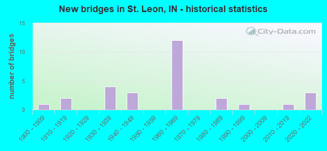
- New bridges - historical statistics
- 11900-1909
- 21910-1919
- 41930-1939
- 31940-1949
- 121960-1969
- 21980-1989
- 11990-1999
- 12010-2019
- 32020-2022

- Reconstructed bridges - Historical Statistics
- 11960-1969
- 21970-1979
- 21980-1989
- 21990-1999
- 12000-2009
- 22010-2019


- Bridge Condition - Deck
- 16.7%Excellent
- 5.6%Very good
- 44.4%Good
- 5.6%Satisfactory
- 27.8%Fair

- Bridge Condition - Superstructure
- 11.1%Excellent
- 11.1%Very good
- 16.7%Good
- 33.3%Satisfactory
- 22.2%Fair
- 5.6%Poor

- Bridge Condition - Substructure
- 11.1%Excellent
- 33.3%Good
- 33.3%Satisfactory
- 11.1%Fair
- 5.6%Poor
- 5.6%Critical

- Bridge Condition - Channel
- 16.7%Excellent
- 16.7%Very good
- 5.6%Good
- 33.3%Satisfactory
- 27.8%Fair

- Bridge Condition - Culverts
- 33.3%Excellent
- 66.7%Fair
Find on map >> Show street view
Structure Number: 5, Location: 00.30 S SR 46 (Lat: 39.278531, Lng: -84.960419), Route carried "on" structure: State highway 1, Year Built: 1961, Year Reconstructed: 2009, Status: Open, Structure Length: 6.42m (21.06ft), Average Daily Traffic: 9,210 (year 2009), Truck Traffic: 5%, Average Future Daily Traffic: 12,836 (year 2032), Design Load: HS 20+Mod, Features Intersected: I-74 EB/WB
Minimum Vertical Clearance: 30+ m (98+ ft), Kilometerpoint: 23.384, Lanes on structure: 3, Lanes under structure: 4, Owner: State Highway Agency, Approaching Roadway Width: 18.9m (62.0ft), Material/Design: Steel continuous, Design/Construction: Stringer/Multi-beam, Number Of Spans In Main Unit: 4, Length of Maximum Span: 20.1m (65.9ft), Curb or Sidewalk Widths: Left: 0.0m, Right: 0.6m (2.0ft), Curb-To-Curb Width: 18.1m (59.4ft), Out-to-Out Width: 19.0m (62.3ft)
Condition: Deck: Good, Superstructure: Very good, Substructure: Good, Operating Rating: 39.5 metric tons, Method Used To Determine Operating Rating: Load and Resistance Factor Rating (LRFR) rating reported by rating factor(RF) method using HL-93 loadings, Inventory Rating: 30.5 metric tons, Method Used To Determine Inventory Rating: Load and Resistance Factor Rating (LRFR) rating reported by rating factor(RF) method using HL-93 loadings, Structural Evaluation: Better than present minimum criteria, Deck Geometry: Superior to present desirable criteria, Underclear: Somewhat better than minimum adequacy, Approach Roadway Alignment: Equal to present desirable criteria, Length Of Structure Improvement: 6.37m (20.90ft), Designated Inspection Frequency: Every 24 months, Inspection Date: July 2021, Bridge Improvement Cost: $3,271,000, Total Project Cost: $3,271,000, Deck Structure Type: Concrete Cast-file-Place, Wearing Surface/Protective System: Wearing Surface: Monolithic Concrete, Deck Protection: Epoxy Coated Reinforcing
Find on map >> Show street view
Structure Number: 1746, Location: 02.81 W SR 1 (Lat: 39.282589, Lng: -85.010619), Route carried "on" structure: State highway 46, Year Built: 1937, Year Reconstructed: 2021, Status: Open, Structure Length: 6.37m (20.90ft), Average Daily Traffic: 4,250 (year 2019), Truck Traffic: 5%, Average Future Daily Traffic: 4,750 (year 2039), Design Load: H 20, Features Intersected: E FORK TANNERS CREEK
Minimum Vertical Clearance: 30+ m (98+ ft), Kilometerpoint: 5.327, Lanes on structure: 2, Owner: State Highway Agency, Approaching Roadway Width: 8.5m (27.9ft), Material/Design: Concrete, Design/Construction: Arch - Deck, Number Of Spans In Main Unit: 3, Length of Maximum Span: 24.4m (80.1ft), Curb-To-Curb Width: 9.4m (30.8ft), Out-to-Out Width: 10.1m (33.1ft)
Condition: Deck: Excellent, Superstructure: Satisfactory, Substructure: Satisfactory, Channel: Very good, Operating Rating: 89.8 metric tons, Method Used To Determine Operating Rating: Load Factor (LF), Inventory Rating: 53.5 metric tons, Method Used To Determine Inventory Rating: Load Factor (LF), Structural Evaluation: Equal to present minimum criteria, Deck Geometry: Meets minimum limits, Waterway Adequacy: Better than present minimum criteria, Approach Roadway Alignment: Equal to present desirable criteria, Designated Inspection Frequency: Every 24 months, Inspection Date: July 2021, Deck Structure Type: Concrete Cast-file-Place, Wearing Surface/Protective System: Wearing Surface: Monolithic Concrete, Deck Protection: Epoxy Coated Reinforcing
Find on map >> Show street view
Structure Number: 1747, Location: 00.74 W SR 1 (Lat: 39.284789, Lng: -84.972489), Route carried "on" structure: State highway 46, Year Built: 1962, Year Reconstructed: 2015, Status: Open, Structure Length: 7.89m (25.89ft), Average Daily Traffic: 4,077 (year 2004), Truck Traffic: 10%, Average Future Daily Traffic: 6,917 (year 2031), Design Load: HL 93, Features Intersected: I-74
Minimum Vertical Clearance: 30+ m (98+ ft), Kilometerpoint: 8.658, Lanes on structure: 2, Lanes under structure: 4, Owner: State Highway Agency, Approaching Roadway Width: 12.2m (40.0ft), Skew: 3 degrees, Material/Design: Steel continuous, Design/Construction: Stringer/Multi-beam, Number Of Spans In Main Unit: 4, Length of Maximum Span: 24.5m (80.4ft), Curb-To-Curb Width: 10.1m (33.1ft), Out-to-Out Width: 11.0m (36.1ft)
Condition: Deck: Very good, Superstructure: Satisfactory, Substructure: Satisfactory, Operating Rating: 53.5 metric tons, Method Used To Determine Operating Rating: Load and Resistance Factor Rating (LRFR) rating reported by rating factor(RF) method using HL-93 loadings, Inventory Rating: 41.5 metric tons, Method Used To Determine Inventory Rating: Load and Resistance Factor Rating (LRFR) rating reported by rating factor(RF) method using HL-93 loadings, Structural Evaluation: Equal to present minimum criteria, Deck Geometry: Meets minimum limits, Underclear: Somewhat better than minimum adequacy, Approach Roadway Alignment: Equal to present desirable criteria, Designated Inspection Frequency: Every 24 months, Other Special Inspection Frequency: Every 60 months, Inspection Date: January 2021, Other Special Inspection Date: August 2017, Deck Structure Type: Concrete Cast-file-Place, Wearing Surface/Protective System: Wearing Surface: Monolithic Concrete, Deck Protection: Epoxy Coated Reinforcing
Find on map >> Show street view
Structure Number: 1748, Location: 00.94 E SR 1 (Lat: 39.280269, Lng: -84.942989), Route carried "on" structure: State highway 46, Year Built: 1937, Status: Open, Structure Length: 0.88m (2.89ft), Average Daily Traffic: 1,134 (year 2004), Truck Traffic: 10%, Average Future Daily Traffic: 1,902 (year 2033), Design Load: H 20, Features Intersected: LOGAN CREEK
Minimum Vertical Clearance: 30+ m (98+ ft), Kilometerpoint: 11.362, Lanes on structure: 2, Owner: State Highway Agency, Approaching Roadway Width: 8.5m (27.9ft), Skew: 2 degrees, Material/Design: Concrete, Design/Construction: Culvert, Number Of Spans In Main Unit: 1, Length of Maximum Span: 7.6m (24.9ft)
Condition: Channel: Very good, Culverts: Fair, Operating Rating: 54.5 metric tons, Method Used To Determine Operating Rating: Field evaluation and documented engineering judgment, Inventory Rating: 32.7 metric tons, Method Used To Determine Inventory Rating: Field evaluation and documented engineering judgment, Structural Evaluation: Somewhat better than minimum adequacy, Waterway Adequacy: Equal to present minimum criteria, Approach Roadway Alignment: Equal to present desirable criteria, Designated Inspection Frequency: Every 24 months, Inspection Date: January 2021
Find on map >> Show street view
Structure Number: 17491, Location: 01.14 E SR 1 (Lat: 39.280950, Lng: -84.939331), Route carried "on" structure: State highway 46, Year Built: 2021, Status: Open, Structure Length: 1.11m (3.64ft), Average Daily Traffic: 1,840 (year 2020), Truck Traffic: 5%, Average Future Daily Traffic: 2,420 (year 2040), Design Load: HL 93, Features Intersected: LOGAN CREEK
Minimum Vertical Clearance: 30+ m (98+ ft), Kilometerpoint: 11.684, Lanes on structure: 2, Owner: State Highway Agency, Approaching Roadway Width: 11.5m (37.7ft), Skew: 2 degrees, Material/Design: Concrete, Design/Construction: Culvert, Number Of Spans In Main Unit: 1, Length of Maximum Span: 10.4m (34.1ft), Curb-To-Curb Width: 11.5m (37.7ft), Out-to-Out Width: 12.2m (40.0ft)
Condition: Channel: Excellent, Culverts: Excellent, Operating Rating: 50.9 metric tons, Method Used To Determine Operating Rating: Load and Resistance Factor Rating (LRFR) rating reported by rating factor(RF) method using HL-93 loadings, Inventory Rating: 39.2 metric tons, Method Used To Determine Inventory Rating: Load and Resistance Factor Rating (LRFR) rating reported by rating factor(RF) method using HL-93 loadings, Structural Evaluation: Superior to present desirable criteria, Deck Geometry: Equal to present minimum criteria, Waterway Adequacy: Superior to present desirable criteria, Approach Roadway Alignment: Equal to present desirable criteria, Designated Inspection Frequency: Every 24 months, Inspection Date: November 2021
Find on map >> Show street view
Structure Number: 17501, Location: 01.28 E SR 1 (Lat: 39.280269, Lng: -84.936950), Route carried "on" structure: State highway 46, Year Built: 2021, Status: Open, Structure Length: 2.27m (7.45ft), Average Daily Traffic: 1,840 (year 2020), Truck Traffic: 5%, Average Future Daily Traffic: 2,420 (year 2040), Design Load: HL 93, Features Intersected: LOGAN CREEK
Minimum Vertical Clearance: 30+ m (98+ ft), Kilometerpoint: 11.909, Lanes on structure: 2, Owner: State Highway Agency, Approaching Roadway Width: 10.1m (33.1ft), Skew: 3 degrees, Material/Design: Prestressed concrete continuous, Design/Construction: Tee Beam, Number Of Spans In Main Unit: 1, Length of Maximum Span: 21.6m (70.9ft), Curb-To-Curb Width: 10.2m (33.5ft), Out-to-Out Width: 11.1m (36.4ft)
Condition: Deck: Excellent, Superstructure: Excellent, Substructure: Excellent, Channel: Excellent, Operating Rating: 51.8 metric tons, Method Used To Determine Operating Rating: Load and Resistance Factor Rating (LRFR) rating reported by rating factor(RF) method using HL-93 loadings, Inventory Rating: 39.9 metric tons, Method Used To Determine Inventory Rating: Load and Resistance Factor Rating (LRFR) rating reported by rating factor(RF) method using HL-93 loadings, Structural Evaluation: Superior to present desirable criteria, Deck Geometry: Somewhat better than minimum adequacy, Waterway Adequacy: Superior to present desirable criteria, Approach Roadway Alignment: Equal to present desirable criteria, Designated Inspection Frequency: Every 24 months, Inspection Date: November 2021, Deck Structure Type: Concrete Cast-file-Place, Wearing Surface/Protective System: Wearing Surface: Monolithic Concrete, Deck Protection: Epoxy Coated Reinforcing
Find on map >> Show street view
Structure Number: 17511, Location: 02.35 E SR 1 (Lat: 39.279681, Lng: -84.918400), Route carried "on" structure: State highway 46, Year Built: 2021, Status: Open, Structure Length: 3.51m (11.52ft), Average Daily Traffic: 1,990 (year 2020), Truck Traffic: 4%, Average Future Daily Traffic: 2,440 (year 2040), Design Load: HL 93, Features Intersected: LOGAN CREEK
Minimum Vertical Clearance: 30+ m (98+ ft), Kilometerpoint: 13.631, Lanes on structure: 2, Owner: State Highway Agency, Approaching Roadway Width: 10.2m (33.5ft), Skew: 1 degrees, Material/Design: Prestressed concrete, Design/Construction: Tee Beam, Number Of Spans In Main Unit: 1, Length of Maximum Span: 34.3m (112.5ft), Curb-To-Curb Width: 10.2m (33.5ft), Out-to-Out Width: 11.1m (36.4ft)
Condition: Deck: Excellent, Superstructure: Excellent, Substructure: Excellent, Channel: Excellent, Operating Rating: 51.5 metric tons, Method Used To Determine Operating Rating: Load and Resistance Factor Rating (LRFR) rating reported by rating factor(RF) method using HL-93 loadings, Inventory Rating: 36.9 metric tons, Method Used To Determine Inventory Rating: Load and Resistance Factor Rating (LRFR) rating reported by rating factor(RF) method using HL-93 loadings, Structural Evaluation: Superior to present desirable criteria, Deck Geometry: Somewhat better than minimum adequacy, Waterway Adequacy: Superior to present desirable criteria, Approach Roadway Alignment: Equal to present desirable criteria, Designated Inspection Frequency: Every 24 months, Inspection Date: August 2021, Deck Structure Type: Concrete Cast-file-Place, Wearing Surface/Protective System: Wearing Surface: Monolithic Concrete, Deck Protection: Epoxy Coated Reinforcing
Find on map >> Show street view
Structure Number: 1752, Location: 02.93 E SR 1 (Lat: 39.278569, Lng: -84.908400), Route carried "on" structure: State highway 46, Year Built: 1937, Year Reconstructed: 1985, Status: Open, Structure Length: 2.68m (8.79ft), Average Daily Traffic: 1,641 (year 2004), Truck Traffic: 10%, Average Future Daily Traffic: 2,751 (year 2033), Design Load: H 20, Features Intersected: LOGAN CREEK
Minimum Vertical Clearance: 30+ m (98+ ft), Kilometerpoint: 14.565, Lanes on structure: 2, Owner: State Highway Agency, Approaching Roadway Width: 9.8m (32.2ft), Material/Design: Steel, Design/Construction: Stringer/Multi-beam, Number Of Spans In Main Unit: 1, Length of Maximum Span: 25.6m (84.0ft), Curb-To-Curb Width: 9.8m (32.2ft), Out-to-Out Width: 10.6m (34.8ft)
Condition: Deck: Good, Superstructure: Satisfactory, Substructure: Satisfactory, Channel: Fair, Operating Rating: 42.8 metric tons, Method Used To Determine Operating Rating: Load and Resistance Factor Rating (LRFR) rating reported by rating factor(RF) method using HL-93 loadings, Inventory Rating: 33.0 metric tons, Method Used To Determine Inventory Rating: Load and Resistance Factor Rating (LRFR) rating reported by rating factor(RF) method using HL-93 loadings, Structural Evaluation: Equal to present minimum criteria, Deck Geometry: Somewhat better than minimum adequacy, Waterway Adequacy: Better than present minimum criteria, Approach Roadway Alignment: Equal to present desirable criteria, Designated Inspection Frequency: Every 24 months, Inspection Date: January 2021, Deck Structure Type: Concrete Cast-file-Place, Wearing Surface/Protective System: Wearing Surface: Monolithic Concrete, Deck Protection: Epoxy Coated Reinforcing
Find on map >> Show street view
Structure Number: 4529, Location: 03.27 E SR 101 (Lat: 39.285539, Lng: -85.039344), Route carried "on" structure: County highway , Year Built: 1962, Year Reconstructed: 2019, Status: Open, Structure Length: 6.10m (20.01ft), Average Daily Traffic: 1,120 (year 2019), Truck Traffic: 8%, Average Future Daily Traffic: 1,140 (year 2039), Design Load: HS 20, Features Intersected: I-74, Facility Carried by Structure: ST PETERS ROAD
Minimum Vertical Clearance: 30+ m (98+ ft), Kilometerpoint: 0.000, Lanes on structure: 2, Lanes under structure: 4, Owner: State Highway Agency, Approaching Roadway Width: 10.4m (34.1ft), Material/Design: Steel continuous, Design/Construction: Stringer/Multi-beam, Number Of Spans In Main Unit: 2, Number Of Approach Spans: 2, Length of Maximum Span: 19.8m (65.0ft), Curb or Sidewalk Widths: Left: 0.6m (2.0ft), Right: 0.6m (2.0ft), Curb-To-Curb Width: 9.1m (29.9ft), Out-to-Out Width: 11.0m (36.1ft)
Condition: Deck: Fair, Superstructure: Satisfactory, Substructure: Satisfactory, Operating Rating: 36.6 metric tons, Method Used To Determine Operating Rating: Load and Resistance Factor Rating (LRFR) rating reported by rating factor(RF) method using HL-93 loadings, Inventory Rating: 28.2 metric tons, Method Used To Determine Inventory Rating: Load and Resistance Factor Rating (LRFR) rating reported by rating factor(RF) method using HL-93 loadings, Structural Evaluation: Equal to present minimum criteria, Deck Geometry: Somewhat better than minimum adequacy, Underclear: Meets minimum limits, Approach Roadway Alignment: Equal to present desirable criteria, Designated Inspection Frequency: Every 24 months, Inspection Date: April 2020, Deck Structure Type: Concrete Cast-file-Place, Wearing Surface/Protective System: Wearing Surface: Latex Concrete
Find on map >> Show street view
Structure Number: 4531, Location: 02.07 W SR 46 (Lat: 39.286169, Lng: -85.009567), Route carried "on" structure: Interstate 74, Year Built: 1962, Year Reconstructed: 1995, Status: Open, Structure Length: 5.67m (18.60ft), Average Daily Traffic: 10,163 (year 2004), Truck Traffic: 10%, Average Future Daily Traffic: 19,732 (year 2033), Design Load: HS 20+Mod, Features Intersected: CO RD, E FK TANNERS CR
Minimum Vertical Clearance: 30+ m (98+ ft), Kilometerpoint: 258.332, Lanes on structure: 2, Lanes under structure: 2, Base Highway Network: Yes (, Subroute: 1), Owner: State Highway Agency, Approaching Roadway Width: 12.8m (42.0ft), Skew: 2 degrees, Material/Design: Steel continuous, Design/Construction: Stringer/Multi-beam, Number Of Spans In Main Unit: 4, Length of Maximum Span: 16.4m (53.8ft), Curb-To-Curb Width: 12.4m (40.7ft), Out-to-Out Width: 13.3m (43.6ft)
Condition: Deck: Good, Superstructure: Good, Substructure: Good, Channel: Good, Operating Rating: 94.2 metric tons, Method Used To Determine Operating Rating: Load Factor (LF), Inventory Rating: 56.4 metric tons, Method Used To Determine Inventory Rating: Load Factor (LF), Structural Evaluation: Better than present minimum criteria, Deck Geometry: Better than present minimum criteria, Underclear: High priority of corrective action, Waterway Adequacy: Better than present minimum criteria, Approach Roadway Alignment: Equal to present desirable criteria, Designated Inspection Frequency: Every 24 months, Inspection Date: June 2020, Deck Structure Type: Concrete Cast-file-Place, Wearing Surface/Protective System: Wearing Surface: Epoxy Overlay, Deck Protection: Epoxy Coated Reinforcing
Find on map >> Show street view
Structure Number: 1500065, Location: 00.30 N OF SR 46 (Lat: 39.281431, Lng: -85.039361), Route carried "on" structure: County highway , Year Built: 1940, Year Reconstructed: 1970, Status: Posted for load, Structure Length: 0.82m (2.69ft), Average Daily Traffic: 1,570 (year 2017), Truck Traffic: 10%, Average Future Daily Traffic: 2,330 (year 2037), Features Intersected: EAST FORK TANNERS CREEK, Facility Carried by Structure: ST PETERS Rd
Minimum Vertical Clearance: 30+ m (98+ ft), Kilometerpoint: 0.000, Lanes on structure: 2, Owner: County Highway Agency, Approaching Roadway Width: 6.4m (21.0ft), Material/Design: Concrete, Design/Construction: Stringer/Multi-beam, Number Of Spans In Main Unit: 1, Length of Maximum Span: 7.3m (24.0ft), Curb-To-Curb Width: 8.7m (28.5ft), Out-to-Out Width: 9.2m (30.2ft)
Condition: Deck: Fair, Superstructure: Poor, Substructure: Critical, Channel: Fair, Operating Rating: 32.7 metric tons, Method Used To Determine Operating Rating: Field evaluation and documented engineering judgment, Inventory Rating: 24.5 metric tons, Method Used To Determine Inventory Rating: Field evaluation and documented engineering judgment, Structural Evaluation: High priority of replacement, Deck Geometry: Somewhat better than minimum adequacy, Waterway Adequacy: Somewhat better than minimum adequacy, Approach Roadway Alignment: Equal to present minimum criteria, Length Of Structure Improvement: 1.49m (4.89ft), Designated Inspection Frequency: Every 12 months, Inspection Date: April 2021, Bridge Improvement Cost: $210,000, Roadway Improvement Cost: $169,000, Total Project Cost: $479,000 ( Estimate for 2017), Deck Structure Type: Concrete Cast-file-Place, Wearing Surface/Protective System: Wearing Surface: Bituminous
Find on map >> Show street view
Structure Number: 1500066, Location: 00.20 N OF SR 46 (Lat: 39.279700, Lng: -85.039381), Route carried "on" structure: County highway , Year Built: 1940, Year Reconstructed: 1970, Status: Posted for load, Structure Length: 0.82m (2.69ft), Average Daily Traffic: 1,570 (year 2017), Truck Traffic: 10%, Average Future Daily Traffic: 2,330 (year 2037), Features Intersected: EAST FORK TANNERS CREEK, Facility Carried by Structure: ST PETERS RD
Minimum Vertical Clearance: 30+ m (98+ ft), Kilometerpoint: 0.000, Lanes on structure: 2, Owner: County Highway Agency, Approaching Roadway Width: 6.7m (22.0ft), Material/Design: Concrete, Design/Construction: Stringer/Multi-beam, Number Of Spans In Main Unit: 1, Length of Maximum Span: 7.3m (24.0ft), Curb-To-Curb Width: 8.7m (28.5ft), Out-to-Out Width: 9.1m (29.9ft)
Condition: Deck: Fair, Superstructure: Fair, Substructure: Fair, Channel: Satisfactory, Operating Rating: 32.7 metric tons, Method Used To Determine Operating Rating: Field evaluation and documented engineering judgment, Inventory Rating: 24.5 metric tons, Method Used To Determine Inventory Rating: Field evaluation and documented engineering judgment, Structural Evaluation: Somewhat better than minimum adequacy, Deck Geometry: Somewhat better than minimum adequacy, Waterway Adequacy: Somewhat better than minimum adequacy, Approach Roadway Alignment: Equal to present minimum criteria, Designated Inspection Frequency: Every 24 months, Inspection Date: April 2021, Deck Structure Type: Concrete Cast-file-Place, Wearing Surface/Protective System: Wearing Surface: Bituminous
Find on map >> Show street view
Structure Number: 1500067, Location: 00.30 S OF COUNTY LINE RD (Lat: 39.304939, Lng: -85.052469), Route carried "on" structure: County highway , Year Built: 1940, Year Reconstructed: 1999, Status: Open, Structure Length: 1.25m (4.10ft), Average Daily Traffic: 100 (year 2017), Truck Traffic: 10%, Average Future Daily Traffic: 150 (year 2037), Design Load: HS 20, Features Intersected: BLUE CREEK, Facility Carried by Structure: BLUE CREEK RD
Minimum Vertical Clearance: 30+ m (98+ ft), Kilometerpoint: 0.000, Lanes on structure: 2, Owner: County Highway Agency, Approaching Roadway Width: 6.1m (20.0ft), Skew: 3 degrees, Material/Design: Prestressed concrete, Design/Construction: Box Beam or Girders - Multiple, Number Of Spans In Main Unit: 1, Length of Maximum Span: 11.6m (38.1ft), Curb-To-Curb Width: 6.0m (19.7ft), Out-to-Out Width: 6.1m (20.0ft)
Condition: Deck: Good, Superstructure: Good, Substructure: Good, Channel: Satisfactory, Operating Rating: 65.1 metric tons, Method Used To Determine Operating Rating: Load Factor (LF), Inventory Rating: 39.0 metric tons, Method Used To Determine Inventory Rating: Load Factor (LF), Structural Evaluation: Better than present minimum criteria, Deck Geometry: Meets minimum limits, Waterway Adequacy: Equal to present minimum criteria, Approach Roadway Alignment: Equal to present minimum criteria, Designated Inspection Frequency: Every 24 months, Inspection Date: April 2021, Deck Structure Type: Concrete Cast-file-Place, Wearing Surface/Protective System: Wearing Surface: Monolithic Concrete, Deck Protection: Epoxy Coated Reinforcing
Find on map >> Show street view
Structure Number: 1500073, Location: 00.30 W OF SR 1 (Lat: 39.262950, Lng: -84.955089), Route carried "on" structure: County highway , Year Built: 1910, Status: Posted for load, Structure Length: 0.82m (2.69ft), Average Daily Traffic: 110 (year 2017), Truck Traffic: 10%, Average Future Daily Traffic: 160 (year 2037), Features Intersected: ENNIS CREEK, Facility Carried by Structure: HYLAND RD
Minimum Vertical Clearance: 30+ m (98+ ft), Kilometerpoint: 0.000, Lanes on structure: 1, Owner: County Highway Agency, Approaching Roadway Width: 5.5m (18.0ft), Material/Design: Concrete, Design/Construction: Culvert, Number Of Spans In Main Unit: 1, Length of Maximum Span: 7.6m (24.9ft), Curb-To-Curb Width: 5.0m (16.4ft), Out-to-Out Width: 5.5m (18.0ft)
Condition: Channel: Satisfactory, Culverts: Fair, Operating Rating: 26.1 metric tons, Method Used To Determine Operating Rating: Field evaluation and documented engineering judgment, Inventory Rating: 15.7 metric tons, Method Used To Determine Inventory Rating: Field evaluation and documented engineering judgment, Structural Evaluation: Meets minimum limits, Deck Geometry: High priority of replacement, Waterway Adequacy: Equal to present minimum criteria, Approach Roadway Alignment: High priority of corrective action, Bridge Posting: Required (Relationship of Operating Rating to Maximum Legal Load: 20.0 - 29.9% below), Length Of Structure Improvement: 0.82m (2.69ft), Designated Inspection Frequency: Every 24 months, Inspection Date: April 2021, Bridge Improvement Cost: $300,000, Roadway Improvement Cost: $200,000, Total Project Cost: $500,000 ( Estimate for 2019), Deck Structure Type: Concrete Cast-file-Place, Wearing Surface/Protective System: Wearing Surface: Bituminous
Find on map >> Show street view
Structure Number: 1500074, Location: 00.60 W OF SR 1 (Lat: 39.242389, Lng: -84.959631), Route carried "on" structure: County highway , Year Built: 1989, Status: Open, Structure Length: 1.01m (3.31ft), Average Daily Traffic: 110 (year 2017), Truck Traffic: 10%, Average Future Daily Traffic: 160 (year 2037), Design Load: HS 20, Features Intersected: ENNIS CREEK, Facility Carried by Structure: ENNIS RIDGE RD
Minimum Vertical Clearance: 30+ m (98+ ft), Kilometerpoint: 0.000, Lanes on structure: 2, Owner: County Highway Agency, Approaching Roadway Width: 6.4m (21.0ft), Skew: 2 degrees, Material/Design: Concrete, Design/Construction: Stringer/Multi-beam, Number Of Spans In Main Unit: 1, Length of Maximum Span: 9.1m (29.9ft), Curb-To-Curb Width: 7.0m (23.0ft), Out-to-Out Width: 7.4m (24.3ft)
Condition: Deck: Good, Superstructure: Satisfactory, Substructure: Satisfactory, Channel: Satisfactory, Operating Rating: 40.8 metric tons, Method Used To Determine Operating Rating: Field evaluation and documented engineering judgment, Inventory Rating: 32.7 metric tons, Method Used To Determine Inventory Rating: Field evaluation and documented engineering judgment, Structural Evaluation: Equal to present minimum criteria, Deck Geometry: Meets minimum limits, Waterway Adequacy: Equal to present minimum criteria, Approach Roadway Alignment: Equal to present desirable criteria, Designated Inspection Frequency: Every 24 months, Inspection Date: April 2021, Deck Structure Type: Concrete Cast-file-Place, Wearing Surface/Protective System: Wearing Surface: Bituminous
Find on map >> Show street view
Structure Number: 1500082, Location: 01.80 E YORK RIDGE (Lat: 39.233239, Lng: -84.963669), Route carried "on" structure: County highway , Year Built: 1989, Status: Open, Structure Length: 5.24m (17.19ft), Average Daily Traffic: 1,410 (year 2017), Truck Traffic: 5%, Average Future Daily Traffic: 2,090 (year 2037), Design Load: HS 20, Features Intersected: E FORK TANNERS CREEK, Facility Carried by Structure: N DEARBORN RD
Minimum Vertical Clearance: 30+ m (98+ ft), Kilometerpoint: 0.000, Lanes on structure: 2, Owner: County Highway Agency, Approaching Roadway Width: 6.4m (21.0ft), Skew: 3 degrees, Material/Design: Prestressed concrete continuous, Design/Construction: Box Beam or Girders - Single/Spread, Number Of Spans In Main Unit: 3, Length of Maximum Span: 17.8m (58.4ft), Curb-To-Curb Width: 8.5m (27.9ft), Out-to-Out Width: 9.4m (30.8ft)
Condition: Deck: Good, Superstructure: Fair, Substructure: Good, Channel: Satisfactory, Operating Rating: 51.1 metric tons, Method Used To Determine Operating Rating: Load Factor (LF), Inventory Rating: 12.7 metric tons, Method Used To Determine Inventory Rating: Load Factor (LF), Structural Evaluation: Meets minimum limits, Deck Geometry: Somewhat better than minimum adequacy, Waterway Adequacy: Equal to present desirable criteria, Approach Roadway Alignment: Equal to present minimum criteria, Designated Inspection Frequency: Every 24 months, Inspection Date: April 2021, Deck Structure Type: Concrete Cast-file-Place, Wearing Surface/Protective System: Wearing Surface: Monolithic Concrete
Find on map >> Show street view
Structure Number: 15001, Location: 00.30 N OF GUTAPFEL RD (Lat: 39.266200, Lng: -85.039481), Route carried "on" structure: County highway , Year Built: 1930, Year Reconstructed: 1960, Status: Posted for load, Structure Length: 0.85m (2.79ft), Average Daily Traffic: 1,260 (year 2017), Truck Traffic: 10%, Average Future Daily Traffic: 1,870 (year 2037), Features Intersected: EAST FORK TANNERS CREEK, Facility Carried by Structure: LAWRENCEVILLE RD
Minimum Vertical Clearance: 30+ m (98+ ft), Kilometerpoint: 0.000, Lanes on structure: 2, Owner: County Highway Agency, Approaching Roadway Width: 6.7m (22.0ft), Material/Design: Concrete, Design/Construction: Slab, Number Of Spans In Main Unit: 1, Length of Maximum Span: 7.9m (25.9ft), Curb-To-Curb Width: 7.6m (24.9ft), Out-to-Out Width: 7.8m (25.6ft)
Condition: Deck: Fair, Superstructure: Fair, Substructure: Satisfactory, Channel: Satisfactory, Operating Rating: 29.4 metric tons, Method Used To Determine Operating Rating: Field evaluation and documented engineering judgment, Inventory Rating: 22.2 metric tons, Method Used To Determine Inventory Rating: Field evaluation and documented engineering judgment, Structural Evaluation: Somewhat better than minimum adequacy, Deck Geometry: Meets minimum limits, Waterway Adequacy: Equal to present minimum criteria, Approach Roadway Alignment: Equal to present desirable criteria, Bridge Posting: Required (Relationship of Operating Rating to Maximum Legal Load: 10.0 - 19.9% below), Length Of Structure Improvement: 1.52m (4.99ft), Designated Inspection Frequency: Every 24 months, Inspection Date: April 2021, Bridge Improvement Cost: $215,000, Roadway Improvement Cost: $169,000, Total Project Cost: $485,000 ( Estimate for 2017), Deck Structure Type: Concrete Cast-file-Place, Wearing Surface/Protective System: Wearing Surface: Bituminous
Find on map >> Show street view
Structure Number: 1500106, Location: 00.50 N OF SR 46 (Lat: 39.283789, Lng: -84.920939), Route carried "on" structure: County highway , Year Built: 1995, Status: Open, Structure Length: 1.82m (5.97ft), Average Daily Traffic: 90 (year 2017), Truck Traffic: 2%, Average Future Daily Traffic: 130 (year 2037), Design Load: HS 20, Features Intersected: LOGAN CREEK, Facility Carried by Structure: BISCHOFF HILL RD
Minimum Vertical Clearance: 30+ m (98+ ft), Kilometerpoint: 0.000, Lanes on structure: 2, Owner: County Highway Agency, Approaching Roadway Width: 6.1m (20.0ft), Skew: 2 degrees, Material/Design: Prestressed concrete, Design/Construction: Box Beam or Girders - Multiple, Number Of Spans In Main Unit: 1, Length of Maximum Span: 17.4m (57.1ft), Curb-To-Curb Width: 6.0m (19.7ft), Out-to-Out Width: 6.1m (20.0ft)
Condition: Deck: Good, Superstructure: Good, Substructure: Good, Channel: Fair, Operating Rating: 55.1 metric tons, Method Used To Determine Operating Rating: Load and Resistance Factor Rating (LRFR) rating reported by rating factor(RF) method using HL-93 loadings, Inventory Rating: 42.4 metric tons, Method Used To Determine Inventory Rating: Load and Resistance Factor Rating (LRFR) rating reported by rating factor(RF) method using HL-93 loadings, Structural Evaluation: Better than present minimum criteria, Deck Geometry: Meets minimum limits, Waterway Adequacy: Better than present minimum criteria, Approach Roadway Alignment: Equal to present desirable criteria, Designated Inspection Frequency: Every 24 months, Inspection Date: April 2021, Deck Structure Type: Concrete Precast Panels, Wearing Surface/Protective System: Wearing Surface: Monolithic Concrete, Membrane: Preformed Fabric
Find on map >> Show street view
Structure Number: 2400059, Location: 01.20 MI. E BLUE CREEK RD (Lat: 39.324689, Lng: -85.019689), Route carried "on" structure: County highway , Year Built: 1908, Year Reconstructed: 1985, Status: Posted for load, Structure Length: 1.27m (4.17ft), Average Daily Traffic: 350 (year 2021), Truck Traffic: 5%, Average Future Daily Traffic: 450 (year 2041), Features Intersected: EAST FORK BLUE CREEK, Facility Carried by Structure: ST PETERS RD
Minimum Vertical Clearance: 30+ m (98+ ft), Kilometerpoint: 0.000, Lanes on structure: 2, Owner: County Highway Agency, Approaching Roadway Width: 5.2m (17.1ft), Material/Design: Prestressed concrete, Design/Construction: Box Beam or Girders - Multiple, Number Of Spans In Main Unit: 1, Length of Maximum Span: 12.3m (40.4ft), Curb-To-Curb Width: 5.9m (19.4ft), Out-to-Out Width: 6.1m (20.0ft)
Condition: Deck: Satisfactory, Superstructure: Satisfactory, Substructure: Poor, Channel: Fair, Operating Rating: 14.5 metric tons, Method Used To Determine Operating Rating: Field evaluation and documented engineering judgment, Inventory Rating: 14.5 metric tons, Method Used To Determine Inventory Rating: Field evaluation and documented engineering judgment, Structural Evaluation: Meets minimum limits, Deck Geometry: High priority of corrective action, Waterway Adequacy: Equal to present minimum criteria, Approach Roadway Alignment: High priority of corrective action, Bridge Posting: Required (Relationship of Operating Rating to Maximum Legal Load: > 39.9% below), Length Of Structure Improvement: 1.83m (6.00ft), Designated Inspection Frequency: Every 12 months, Inspection Date: October 2021, Bridge Improvement Cost: $325,000, Roadway Improvement Cost: $175,000, Total Project Cost: $500,000 ( Estimate for 2021), Deck Structure Type: Concrete Precast Panels, Wearing Surface/Protective System: Wearing Surface: Bituminous
Find on map >> Show street view
Structure Number: 240006, Location: 00.20 S of ST PETERS RD (Lat: 39.318119, Lng: -85.003861), Route carried "on" structure: Alternate County highway , Year Built: 1915, Status: Posted for load, Structure Length: 0.69m (2.26ft), Average Daily Traffic: 225 (year 2020), Truck Traffic: 5%, Average Future Daily Traffic: 300 (year 2040), Features Intersected: EAST FORK BLUE CREEK, Facility Carried by Structure: HIGHLAND CENTER RD
Minimum Vertical Clearance: 30+ m (98+ ft), Kilometerpoint: 0.000, Lanes on structure: 2, Owner: County Highway Agency, Approaching Roadway Width: 4.6m (15.1ft), Material/Design: Concrete, Design/Construction: Slab, Number Of Spans In Main Unit: 1, Length of Maximum Span: 6.5m (21.3ft), Curb-To-Curb Width: 6.1m (20.0ft), Out-to-Out Width: 6.7m (22.0ft)
Condition: Deck: Fair, Superstructure: Fair, Substructure: Fair, Channel: Fair, Operating Rating: 12.7 metric tons, Method Used To Determine Operating Rating: Field evaluation and documented engineering judgment, Inventory Rating: 12.7 metric tons, Method Used To Determine Inventory Rating: Field evaluation and documented engineering judgment, Structural Evaluation: Meets minimum limits, Deck Geometry: Meets minimum limits, Waterway Adequacy: Somewhat better than minimum adequacy, Approach Roadway Alignment: Equal to present minimum criteria, Bridge Posting: Required (Relationship of Operating Rating to Maximum Legal Load: > 39.9% below), Designated Inspection Frequency: Every 24 months, Inspection Date: October 2020, Deck Structure Type: Concrete Cast-file-Place, Wearing Surface/Protective System: Wearing Surface: Bituminous
Find on map >> Show street view
Structure Number: 2400134, Location: 00.20 NW STURWOLD (Lat: 39.345050, Lng: -85.031711), Route carried "on" structure: County highway , Year Built: 2010, Status: Open, Structure Length: 4.68m (15.35ft), Average Daily Traffic: 525 (year 2020), Truck Traffic: 5%, Average Future Daily Traffic: 675 (year 2040), Design Load: HS 20, Features Intersected: E FORK BLUE CREEK, Facility Carried by Structure: BLUE CREEK RD
Minimum Vertical Clearance: 30+ m (98+ ft), Kilometerpoint: 0.000, Lanes on structure: 2, Owner: County Highway Agency, Approaching Roadway Width: 7.0m (23.0ft), Skew: 5 degrees, Material/Design: Prestressed concrete continuous, Design/Construction: Stringer/Multi-beam, Number Of Spans In Main Unit: 3, Length of Maximum Span: 17.0m (55.8ft), Curb-To-Curb Width: 9.1m (29.9ft), Out-to-Out Width: 9.8m (32.2ft)
Condition: Deck: Good, Superstructure: Very good, Substructure: Good, Channel: Very good, Operating Rating: 55.1 metric tons, Method Used To Determine Operating Rating: Load Factor (LF), Inventory Rating: 25.5 metric tons, Method Used To Determine Inventory Rating: Load Factor (LF), Structural Evaluation: Equal to present minimum criteria, Deck Geometry: Equal to present minimum criteria, Waterway Adequacy: Equal to present desirable criteria, Approach Roadway Alignment: Equal to present desirable criteria, Designated Inspection Frequency: Every 24 months, Inspection Date: October 2020, Deck Structure Type: Concrete Cast-file-Place, Wearing Surface/Protective System: Wearing Surface: Monolithic Concrete, Deck Protection: Epoxy Coated Reinforcing
Find on map >> Show street view
Structure Number: 5, Location: 00.30 S SR 46 (Lat: 39.278531, Lng: -84.960419), Route carried "under" structure: Interstate 74, Year Built: 1961, Structure Length: 0. m, Average Daily Traffic: 14,715 (year 2004), Truck Traffic: 10%, Features Intersected: I-74 EB, Facility Carried by Structure: SR 1
Minimum Vertical Clearance: 5.36m (17.59ft), Kilometerpoint: 263.047, Lanes on structure: 3, Lanes under structure: 2, Material/Design: Steel continuous, Design/Construction: Stringer/Multi-beam, Length of Maximum Span: 20.1m (65.9ft)
Find on map >> Show street view
Structure Number: 5, Location: 00.30 S SR 46 (Lat: 39.278531, Lng: -84.960419), Route carried "under" structure: Interstate 74, Year Built: 1961, Structure Length: 0. m, Average Daily Traffic: 14,715 (year 2004), Truck Traffic: 10%, Features Intersected: I-74 WB, Facility Carried by Structure: SR 1
Minimum Vertical Clearance: 5.28m (17.32ft), Kilometerpoint: 263.047, Lanes on structure: 3, Lanes under structure: 2, Material/Design: Steel continuous, Design/Construction: Stringer/Multi-beam, Length of Maximum Span: 20.1m (65.9ft)
Find on map >> Show street view
Structure Number: 1747, Location: 00.74 W SR 1 (Lat: 39.284789, Lng: -84.972497), Route carried "under" structure: Interstate 74, Year Built: 1962, Structure Length: 0. m, Average Daily Traffic: 12,534 (year 2004), Truck Traffic: 10%, Features Intersected: SR 46
Minimum Vertical Clearance: 5.28m (17.32ft), Kilometerpoint: 261.663, Lanes on structure: 2, Lanes under structure: 4, Material/Design: Steel continuous, Design/Construction: Stringer/Multi-beam, Length of Maximum Span: 24.5m (80.4ft)
Find on map >> Show street view
Structure Number: 1747, Location: 00.74 W SR 1 (Lat: 39.284789, Lng: -84.972497), Route carried "under" structure: Interstate 74, Year Built: 1962, Structure Length: 0. m, Average Daily Traffic: 12,534 (year 2004), Truck Traffic: 10%, Features Intersected: SR 46
Minimum Vertical Clearance: 5.51m (18.08ft), Kilometerpoint: 261.663, Lanes on structure: 2, Lanes under structure: 2, Material/Design: Steel continuous, Design/Construction: Stringer/Multi-beam, Length of Maximum Span: 24.5m (80.4ft)
Find on map >> Show street view
Structure Number: 4529, Location: 03.27 E SR 101 (Lat: 39.285539, Lng: -85.039344), Route carried "under" structure: Interstate 74, Year Built: 1962, Structure Length: 0. m, Average Daily Traffic: 10,163 (year 2004), Truck Traffic: 10%, Features Intersected: I-74 EB, Facility Carried by Structure: ST PETERS ROAD
Minimum Vertical Clearance: 4.90m (16.08ft), Kilometerpoint: 255.757, Lanes on structure: 2, Lanes under structure: 4, Material/Design: Steel continuous, Design/Construction: Stringer/Multi-beam, Length of Maximum Span: 19.8m (65.0ft)
Find on map >> Show street view
Structure Number: 4529, Location: 03.27 E SR 101 (Lat: 39.285539, Lng: -85.039344), Route carried "under" structure: Interstate 74, Year Built: 1962, Structure Length: 0. m, Average Daily Traffic: 10,163 (year 2004), Truck Traffic: 10%, Features Intersected: I-74 WB, Facility Carried by Structure: ST PETERS ROAD
Minimum Vertical Clearance: 4.93m (16.17ft), Kilometerpoint: 255.757, Lanes on structure: 2, Lanes under structure: 4, Material/Design: Steel continuous, Design/Construction: Stringer/Multi-beam, Length of Maximum Span: 19.8m (65.0ft)
Find on map >> Show street view
Structure Number: 453, Location: 02.07 W SR 46 (Lat: 39.285911, Lng: -85.009644), Route carried "under" structure: County highway , Year Built: 1962, Structure Length: 0. m, Average Daily Traffic: 132 (year 2004), Truck Traffic: 5%, Features Intersected: CO RD, Facility Carried by Structure: I-74 EB
Minimum Vertical Clearance: 4.47m (14.67ft), Kilometerpoint: 0.000, Lanes on structure: 2, Lanes under structure: 2, Material/Design: Steel continuous, Design/Construction: Stringer/Multi-beam, Length of Maximum Span: 16.4m (53.8ft)
Find on map >> Show street view
Structure Number: 4531, Location: 02.07 W SR 46 (Lat: 39.286169, Lng: -85.009567), Route carried "under" structure: County highway , Year Built: 1962, Structure Length: 0. m, Average Daily Traffic: 132 (year 2004), Truck Traffic: 5%, Features Intersected: CO RD, Facility Carried by Structure: I-74 WB
Minimum Vertical Clearance: 4.47m (14.67ft), Kilometerpoint: 0.000, Lanes on structure: 2, Lanes under structure: 2, Material/Design: Steel continuous, Design/Construction: Stringer/Multi-beam, Length of Maximum Span: 16.4m (53.8ft)