Bridge Statistics for St. Mary, Missouri (MO)
Condition, Traffic, Stress, Structural Evaluation, Project Costs
- National Bridge Inventory (NBI) Statistics
- 11Number of bridges
- 148ft / 44.5mTotal length
- $436,000Total costs
- 35,680Total average daily traffic
- 7,946Total average daily truck traffic
- National Bridge Inventory (NBI) Registered Bridges for St. Mary
- No street view available for this location
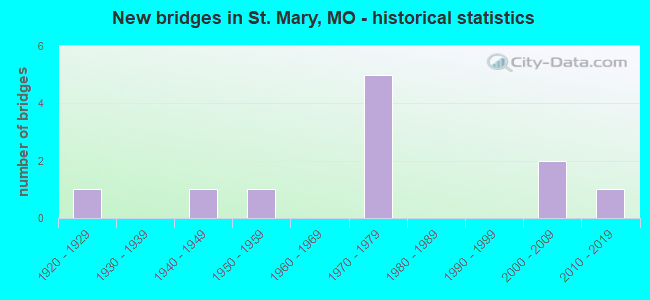
- New bridges - historical statistics
- 11920-1929
- 11940-1949
- 11950-1959
- 51970-1979
- 22000-2009
- 12010-2019


- Bridge Condition - Deck
- 11.1%Excellent
- 22.2%Very good
- 44.4%Good
- 22.2%Satisfactory

- Bridge Condition - Superstructure
- 11.1%Excellent
- 22.2%Very good
- 44.4%Good
- 11.1%Satisfactory
- 11.1%Serious

- Bridge Condition - Substructure
- 11.1%Excellent
- 33.3%Very good
- 22.2%Good
- 22.2%Satisfactory
- 11.1%Poor

- Bridge Condition - Channel
- 12.5%Excellent
- 37.5%Good
- 25.0%Satisfactory
- 25.0%Fair
Find on map >> Show street view
Structure Number: 13765, Location: S 86 T 36 N R 10 E (Lat: 37.850572, Lng: -89.934392), Route carried "on" structure: County highway 47, Year Built: 1940, Status: Posted for load, Structure Length: 0.94m (3.08ft), Average Daily Traffic: 35 (year 2021), Truck Traffic: 10%, Average Future Daily Traffic: 47 (year 2041), Features Intersected: ST LAURENT CR, Facility Carried by Structure: COUNTY RD 930
Minimum Vertical Clearance: 30+ m (98+ ft), Kilometerpoint: 0.644, Lanes on structure: 1, Owner: County Highway Agency, Approaching Roadway Width: 5.2m (17.1ft), Material/Design: Steel, Design/Construction: Stringer/Multi-beam, Number Of Spans In Main Unit: 1, Length of Maximum Span: 8.2m (26.9ft), Curb-To-Curb Width: 4.1m (13.5ft), Out-to-Out Width: 4.1m (13.5ft)
Condition: Deck: Satisfactory, Superstructure: Satisfactory, Substructure: Satisfactory, Channel: Satisfactory, Operating Rating: 19.8 metric tons, Method Used To Determine Operating Rating: Allowable Stress (AS), Inventory Rating: 9.9 metric tons, Method Used To Determine Inventory Rating: Allowable Stress (AS), Structural Evaluation: High priority of replacement, Deck Geometry: Somewhat better than minimum adequacy, Waterway Adequacy: Better than present minimum criteria, Approach Roadway Alignment: Equal to present minimum criteria, Bridge Posting: Required (Relationship of Operating Rating to Maximum Legal Load: 10.0 - 19.9% below), Length Of Structure Improvement: 0.16m (0.52ft), Designated Inspection Frequency: Every 24 months, Inspection Date: January 2021, Bridge Improvement Cost: $115,000, Roadway Improvement Cost: $12,000, Total Project Cost: $173,000 ( Estimate for 2022), Deck Structure Type: Concrete Cast-file-Place, Wearing Surface/Protective System: Wearing Surface: Monolithic Concrete
Find on map >> Show street view
Structure Number: 13775, Location: S 86 T 36 N R 10 E (Lat: 37.845986, Lng: -89.929089), Route carried "on" structure: County highway 47, Year Built: 1950, Year Reconstructed: 1984, Status: Open, Structure Length: 0.94m (3.08ft), Average Daily Traffic: 35 (year 2021), Truck Traffic: 10%, Average Future Daily Traffic: 47 (year 2041), Features Intersected: CREEK, Facility Carried by Structure: COUNTY RD 930
Minimum Vertical Clearance: 30+ m (98+ ft), Kilometerpoint: 1.609, Lanes on structure: 1, Owner: County Highway Agency, Approaching Roadway Width: 4.9m (16.1ft), Material/Design: Steel, Design/Construction: Stringer/Multi-beam, Number Of Spans In Main Unit: 1, Length of Maximum Span: 9.1m (29.9ft), Curb-To-Curb Width: 5.4m (17.7ft), Out-to-Out Width: 5.4m (17.7ft)
Condition: Deck: Satisfactory, Superstructure: Good, Substructure: Good, Channel: Good, Operating Rating: 36.9 metric tons, Method Used To Determine Operating Rating: Allowable Stress (AS), Inventory Rating: 22.5 metric tons, Method Used To Determine Inventory Rating: Allowable Stress (AS), Structural Evaluation: Equal to present minimum criteria, Deck Geometry: High priority of corrective action, Waterway Adequacy: Better than present minimum criteria, Approach Roadway Alignment: Equal to present desirable criteria, Designated Inspection Frequency: Every 24 months, Inspection Date: January 2021, Deck Structure Type: Concrete Cast-file-Place, Wearing Surface/Protective System: Wearing Surface: Monolithic Concrete
Find on map >> Show street view
Structure Number: 2119, Location: S 3015 T 36 N R 9 E (Lat: 37.831844, Lng: -89.983375), Route carried "on" structure: Interstate 55, Year Built: 1970, Year Reconstructed: 1984, Status: Open, Structure Length: 9.88m (32.41ft), Average Daily Traffic: 9,954 (year 2021), Truck Traffic: 22%, Average Future Daily Traffic: 18,913 (year 2041), Design Load: HS 20+Mod, Features Intersected: SALINE CR
Minimum Vertical Clearance: 30+ m (98+ ft), Kilometerpoint: 112.778, Lanes on structure: 2, Base Highway Network: Yes, Owner: State Highway Agency, Approaching Roadway Width: 11.6m (38.1ft), Skew: 2 degrees, Material/Design: Steel continuous, Design/Construction: Stringer/Multi-beam, Number Of Spans In Main Unit: 5, Length of Maximum Span: 21.9m (71.9ft), Curb-To-Curb Width: 11.6m (38.1ft), Out-to-Out Width: 12.4m (40.7ft)
Condition: Deck: Good, Superstructure: Good, Substructure: Good, Channel: Fair, Operating Rating: 45.9 metric tons, Method Used To Determine Operating Rating: Load Factor (LF), Inventory Rating: 27.0 metric tons, Method Used To Determine Inventory Rating: Load Factor (LF), Structural Evaluation: Equal to present minimum criteria, Deck Geometry: Equal to present minimum criteria, Waterway Adequacy: Equal to present desirable criteria, Approach Roadway Alignment: Equal to present desirable criteria, Designated Inspection Frequency: Every 24 months, Inspection Date: October 2021, Deck Structure Type: Concrete Cast-file-Place, Wearing Surface/Protective System: Wearing Surface: Low Slump Concrete, Membrane: Built-up, Deck Protection: Internally Sealed
Find on map >> Show street view
Structure Number: 212, Location: S 3015 T 36 N R 9 E (Lat: 37.832047, Lng: -89.983214), Route carried "on" structure: Interstate 55, Year Built: 1970, Year Reconstructed: 1984, Status: Open, Structure Length: 9.88m (32.41ft), Average Daily Traffic: 5,636 (year 2021), Truck Traffic: 22%, Average Future Daily Traffic: 10,708 (year 2041), Design Load: HS 20+Mod, Features Intersected: SALINE CR
Minimum Vertical Clearance: 30+ m (98+ ft), Kilometerpoint: 224.847, Lanes on structure: 2, Base Highway Network: Yes, Owner: State Highway Agency, Approaching Roadway Width: 11.6m (38.1ft), Skew: 2 degrees, Material/Design: Steel continuous, Design/Construction: Stringer/Multi-beam, Number Of Spans In Main Unit: 5, Length of Maximum Span: 21.9m (71.9ft), Curb-To-Curb Width: 11.6m (38.1ft), Out-to-Out Width: 12.4m (40.7ft)
Condition: Deck: Good, Superstructure: Good, Substructure: Satisfactory, Channel: Fair, Operating Rating: 45.9 metric tons, Method Used To Determine Operating Rating: Load Factor (LF), Inventory Rating: 27.0 metric tons, Method Used To Determine Inventory Rating: Load Factor (LF), Structural Evaluation: Equal to present minimum criteria, Deck Geometry: Equal to present minimum criteria, Waterway Adequacy: Equal to present desirable criteria, Approach Roadway Alignment: Equal to present desirable criteria, Designated Inspection Frequency: Every 24 months, Inspection Date: October 2021, Deck Structure Type: Concrete Cast-file-Place, Wearing Surface/Protective System: Wearing Surface: Low Slump Concrete, Membrane: Built-up, Deck Protection: Other
Find on map >> Show street view
Structure Number: 2121, Location: S 3015 T 36 N R 9 E (Lat: 37.828869, Lng: -89.979586), Route carried "on" structure: County highway 830, Year Built: 1970, Status: Open, Structure Length: 7.53m (24.70ft), Average Daily Traffic: 66 (year 2021), Truck Traffic: 9%, Average Future Daily Traffic: 92 (year 2041), Design Load: H 15, Features Intersected: IS 55
Minimum Vertical Clearance: 30+ m (98+ ft), Kilometerpoint: 0.890, Lanes on structure: 2, Lanes under structure: 4, Owner: State Highway Agency, Approaching Roadway Width: 6.1m (20.0ft), Material/Design: Steel continuous, Design/Construction: Stringer/Multi-beam, Number Of Spans In Main Unit: 2, Number Of Approach Spans: 2, Length of Maximum Span: 26.2m (86.0ft), Curb-To-Curb Width: 8.5m (27.9ft), Out-to-Out Width: 9.4m (30.8ft)
Condition: Deck: Good, Superstructure: Good, Substructure: Very good, Operating Rating: 27.9 metric tons, Method Used To Determine Operating Rating: Allowable Stress (AS), Inventory Rating: 16.2 metric tons, Method Used To Determine Inventory Rating: Allowable Stress (AS), Structural Evaluation: Somewhat better than minimum adequacy, Deck Geometry: Better than present minimum criteria, Underclear: Somewhat better than minimum adequacy, Approach Roadway Alignment: Equal to present desirable criteria, Designated Inspection Frequency: Every 24 months, Other Special Inspection Frequency: Every 24 months, Inspection Date: September 2021, Other Special Inspection Date: September 2021, Deck Structure Type: Concrete Cast-file-Place, Wearing Surface/Protective System: Wearing Surface: Monolithic Concrete
Find on map >> Show street view
Structure Number: 23059, Location: S 1862 T 37 N R 10 E (Lat: 37.873828, Lng: -89.940875), Route carried "on" structure: City street , Year Built: 1920, Status: Posted for load, Structure Length: 1.68m (5.51ft), Average Daily Traffic: 10 (year 2020), Truck Traffic: 20%, Average Future Daily Traffic: 14 (year 2040), Design Load: HS 20, Features Intersected: LAUREN CR, Facility Carried by Structure: 2ND ST. ST MARYS
Minimum Vertical Clearance: 30+ m (98+ ft), Kilometerpoint: 0.322, Lanes on structure: 1, Owner: County Highway Agency, Approaching Roadway Width: 6.1m (20.0ft), Material/Design: Steel, Design/Construction: Truss - Thru, Number Of Spans In Main Unit: 1, Length of Maximum Span: 15.8m (51.8ft), Curb-To-Curb Width: 4.2m (13.8ft), Out-to-Out Width: 4.3m (14.1ft)
Condition: Deck: Excellent, Superstructure: Serious, Substructure: Poor, Channel: Satisfactory, Operating Rating: 6.3 metric tons, Method Used To Determine Operating Rating: Allowable Stress (AS), Inventory Rating: 3.6 metric tons, Method Used To Determine Inventory Rating: Allowable Stress (AS), Structural Evaluation: High priority of replacement, Deck Geometry: Somewhat better than minimum adequacy, Waterway Adequacy: Somewhat better than minimum adequacy, Approach Roadway Alignment: Equal to present minimum criteria, Bridge Posting: Required (Relationship of Operating Rating to Maximum Legal Load: > 39.9% below), Length Of Structure Improvement: 0.24m (0.79ft), Designated Inspection Frequency: Every 24 months, Critical Feature Inspection Frequency: Every 24 months, Inspection Date: Febuary 2022, Critical Feature Inspection Date: Febuary 2022, Bridge Improvement Cost: $175,000, Roadway Improvement Cost: $18,000, Total Project Cost: $263,000 ( Estimate for 2022), Deck Structure Type: Wood or Timber, Wearing Surface/Protective System: Wearing Surface: Wood or Timber
Find on map >> Show street view
Structure Number: 29632, Location: S 3221 T 37 N R 9 E (Lat: 37.901419, Lng: -89.978219), Route carried "on" structure: US 61, Year Built: 2003, Status: Open, Structure Length: 9.51m (31.20ft), Average Daily Traffic: 2,224 (year 2021), Truck Traffic: 21%, Average Future Daily Traffic: 3,114 (year 2041), Design Load: HS 20, Features Intersected: SALINE CR
Minimum Vertical Clearance: 30+ m (98+ ft), Kilometerpoint: 379.022, Lanes on structure: 2, Owner: State Highway Agency, Approaching Roadway Width: 12.2m (40.0ft), Material/Design: Steel continuous, Design/Construction: Stringer/Multi-beam, Number Of Spans In Main Unit: 3, Length of Maximum Span: 45.7m (149.9ft), Curb-To-Curb Width: 12.2m (40.0ft), Out-to-Out Width: 13.0m (42.7ft)
Condition: Deck: Good, Superstructure: Very good, Substructure: Excellent, Channel: Good, Operating Rating: 72.9 metric tons, Method Used To Determine Operating Rating: Load Factor (LF), Inventory Rating: 44.1 metric tons, Method Used To Determine Inventory Rating: Load Factor (LF), Structural Evaluation: Equal to present desirable criteria, Deck Geometry: Equal to present minimum criteria, Waterway Adequacy: Superior to present desirable criteria, Approach Roadway Alignment: Equal to present desirable criteria, Designated Inspection Frequency: Every 24 months, Inspection Date: October 2020, Deck Structure Type: Concrete Cast-file-Place, Wearing Surface/Protective System: Wearing Surface: Monolithic Concrete, Deck Protection: Epoxy Coated Reinforcing
Find on map >> Show street view
Structure Number: 30962, Location: S 962 T 36 N R 10 E (Lat: 37.853792, Lng: -89.932897), Route carried "on" structure: County highway 930, Year Built: 2005, Status: Open, Structure Length: 1.95m (6.40ft), Average Daily Traffic: 35 (year 2021), Truck Traffic: 10%, Average Future Daily Traffic: 47 (year 2041), Design Load: HS 20, Features Intersected: ST LAURENT CR
Minimum Vertical Clearance: 30+ m (98+ ft), Kilometerpoint: 0.000, Lanes on structure: 2, Owner: County Highway Agency, Approaching Roadway Width: 7.3m (24.0ft), Material/Design: Prestressed concrete, Design/Construction: Box Beam or Girders - Multiple, Number Of Spans In Main Unit: 1, Length of Maximum Span: 19.2m (63.0ft), Curb-To-Curb Width: 7.3m (24.0ft), Out-to-Out Width: 7.3m (24.0ft)
Condition: Deck: Very good, Superstructure: Very good, Substructure: Very good, Channel: Excellent, Operating Rating: 57.6 metric tons, Method Used To Determine Operating Rating: Load Factor (LF), Inventory Rating: 34.2 metric tons, Method Used To Determine Inventory Rating: Load Factor (LF), Structural Evaluation: Equal to present desirable criteria, Deck Geometry: Equal to present minimum criteria, Waterway Adequacy: Superior to present desirable criteria, Approach Roadway Alignment: Equal to present desirable criteria, Designated Inspection Frequency: Every 24 months, Inspection Date: January 2021, Deck Structure Type: Other, Wearing Surface/Protective System: Wearing Surface: Bituminous
Find on map >> Show street view
Structure Number: 34327, Location: S 962 T 34 N R 10 E (Lat: 37.860283, Lng: -89.938053), Route carried "on" structure: State highway H, Year Built: 2013, Status: Open, Structure Length: 2.19m (7.19ft), Average Daily Traffic: 2,095 (year 2021), Truck Traffic: 29%, Average Future Daily Traffic: 2,933 (year 2041), Features Intersected: ST. LAURENT CR
Minimum Vertical Clearance: 30+ m (98+ ft), Kilometerpoint: 1.355, Lanes on structure: 2, Owner: State Highway Agency, Approaching Roadway Width: 8.5m (27.9ft), Skew: 2 degrees, Material/Design: Prestressed concrete, Design/Construction: Stringer/Multi-beam, Number Of Spans In Main Unit: 1, Length of Maximum Span: 20.7m (67.9ft), Curb-To-Curb Width: 8.5m (27.9ft), Out-to-Out Width: 9.3m (30.5ft)
Condition: Deck: Very good, Superstructure: Excellent, Substructure: Very good, Channel: Good, Operating Rating: 67.5 metric tons, Method Used To Determine Operating Rating: Load Factor (LF), Inventory Rating: 28.8 metric tons, Method Used To Determine Inventory Rating: Load Factor (LF), Structural Evaluation: Better than present minimum criteria, Deck Geometry: Meets minimum limits, Waterway Adequacy: Superior to present desirable criteria, Approach Roadway Alignment: Equal to present desirable criteria, Designated Inspection Frequency: Every 24 months, Inspection Date: October 2021, Deck Structure Type: Concrete Cast-file-Place, Wearing Surface/Protective System: Wearing Surface: Monolithic Concrete, Deck Protection: Epoxy Coated Reinforcing
Find on map >> Show street view
Structure Number: 2121, Location: S 3015 T 36 N R 9 E (Lat: 37.828869, Lng: -89.979586), Route carried "under" structure: Interstate 55, Year Built: 1970, Structure Length: 0. m, Average Daily Traffic: 9,954 (year 2021), Truck Traffic: 22%, Features Intersected: IS 55, Facility Carried by Structure: 830 E
Minimum Vertical Clearance: 5.00m (16.40ft), Kilometerpoint: 113.304, Lanes on structure: 2, Lanes under structure: 2, Material/Design: Steel continuous, Design/Construction: Stringer/Multi-beam, Length of Maximum Span: 26.2m (86.0ft)
Find on map >> Show street view
Structure Number: 2121, Location: S 3015 T 36 N R 9 E (Lat: 37.828869, Lng: -89.979586), Route carried "under" structure: Interstate 55, Year Built: 1970, Structure Length: 0. m, Average Daily Traffic: 5,636 (year 2021), Truck Traffic: 22%, Features Intersected: IS 55, Facility Carried by Structure: 830 E
Minimum Vertical Clearance: 5.41m (17.75ft), Kilometerpoint: 224.428, Lanes on structure: 2, Lanes under structure: 2, Material/Design: Steel continuous, Design/Construction: Stringer/Multi-beam, Length of Maximum Span: 26.2m (86.0ft)