Bridge Statistics for St. Pauls, North Carolina (NC)
Condition, Traffic, Stress, Structural Evaluation, Project Costs
- National Bridge Inventory (NBI) Statistics
- 30Number of bridges
- 282ft / 85.9mTotal length
- 471,290Total average daily traffic
- 95,084Total average daily truck traffic
- National Bridge Inventory (NBI) Registered Bridges for St. Pauls
- No street view available for this location
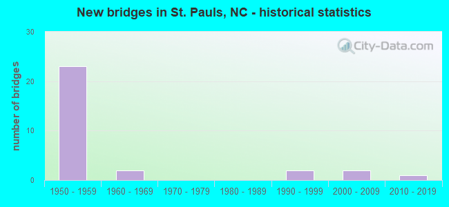
- New bridges - historical statistics
- 231950-1959
- 21960-1969
- 21990-1999
- 22000-2009
- 12010-2019


- Bridge Condition - Deck
- 12.5%Very good
- 56.3%Good
- 18.8%Satisfactory
- 6.3%Fair
- 6.3%Poor

- Bridge Condition - Superstructure
- 12.5%Very good
- 25.0%Good
- 50.0%Satisfactory
- 6.3%Fair
- 6.3%Poor

- Bridge Condition - Substructure
- 12.5%Very good
- 37.5%Good
- 25.0%Satisfactory
- 18.8%Fair
- 6.3%Serious

- Bridge Condition - Channel
- 8.3%Very good
- 83.3%Good
- 8.3%Fair

- Bridge Condition - Culverts
- 50.0%Satisfactory
- 50.0%Fair
Find on map >> Show street view
Structure Number: 1550022, Location: 0.6 MI. S. JCT. SR1006 (Lat: 34.793228, Lng: -78.969197), Route carried "on" structure: State highway 1916, Year Built: 2000, Status: Open, Structure Length: 0.94m (3.08ft), Average Daily Traffic: 1,700 (year 1995), Truck Traffic: 6%, Average Future Daily Traffic: 3,400 (year 2040), Design Load: HS 20+Mod, Features Intersected: BIG MARSH SWAMP
Minimum Vertical Clearance: 30+ m (98+ ft), Kilometerpoint: 0.000, Lanes on structure: 2, Owner: State Highway Agency, Approaching Roadway Width: 7.0m (23.0ft), Material/Design: Concrete continuous, Design/Construction: Culvert, Number Of Spans In Main Unit: 3, Length of Maximum Span: 3.0m (9.8ft)
Condition: Channel: Good, Culverts: Fair, Operating Rating: 64.4 metric tons, Method Used To Determine Operating Rating: Load and Resistance Factor (LRFR), Inventory Rating: 49.8 metric tons, Method Used To Determine Inventory Rating: Load and Resistance Factor (LRFR), Structural Evaluation: Somewhat better than minimum adequacy, Waterway Adequacy: Better than present minimum criteria, Approach Roadway Alignment: Equal to present desirable criteria, Designated Inspection Frequency: Every 24 months, Underwater Inspection Frequency: Every 60 months, Inspection Date: October 2021, Underwater Inspection Date: October 2021
Find on map >> Show street view
Structure Number: 1550023, Location: 0.2MI.W. JCT SR1906 (Lat: 34.818733, Lng: -78.928867), Route carried "on" structure: State highway 1907, Year Built: 1990, Status: Open, Structure Length: 3.87m (12.70ft), Average Daily Traffic: 2,300 (year 2017), Truck Traffic: 6%, Average Future Daily Traffic: 4,600 (year 2040), Design Load: HS 20+Mod, Features Intersected: LITTLE MARSH SWAMP
Minimum Vertical Clearance: 30+ m (98+ ft), Kilometerpoint: 0.000, Lanes on structure: 2, Owner: State Highway Agency, Approaching Roadway Width: 8.2m (26.9ft), Material/Design: Prestressed concrete, Design/Construction: Slab, Number Of Spans In Main Unit: 3, Length of Maximum Span: 13.4m (44.0ft), Curb-To-Curb Width: 8.2m (26.9ft), Out-to-Out Width: 9.1m (29.9ft)
Condition: Deck: Good, Superstructure: Good, Substructure: Good, Channel: Good, Operating Rating: 89.8 metric tons, Method Used To Determine Operating Rating: Load Factor (LF), Inventory Rating: 57.1 metric tons, Method Used To Determine Inventory Rating: Load Factor (LF), Structural Evaluation: Better than present minimum criteria, Deck Geometry: High priority of corrective action, Waterway Adequacy: Better than present minimum criteria, Approach Roadway Alignment: Equal to present desirable criteria, Designated Inspection Frequency: Every 24 months, Inspection Date: December 2020, Deck Structure Type: Concrete Precast Panels, Wearing Surface/Protective System: Wearing Surface: Bituminous
Find on map >> Show street view
Structure Number: 1550059, Location: 1.2 MI SOUTH OF NC20 (Lat: 34.782114, Lng: -78.922711), Route carried "on" structure: State highway 1924, Year Built: 2018, Status: Open, Structure Length: 5.48m (17.98ft), Average Daily Traffic: 2,900 (year 2017), Truck Traffic: 6%, Average Future Daily Traffic: 5,800 (year 2040), Design Load: HL 93, Features Intersected: BIG MARSH SWAMP
Minimum Vertical Clearance: 30+ m (98+ ft), Kilometerpoint: 0.000, Lanes on structure: 2, Owner: State Highway Agency, Approaching Roadway Width: 9.4m (30.8ft), Material/Design: Prestressed concrete, Design/Construction: Slab, Number Of Spans In Main Unit: 3, Length of Maximum Span: 17.9m (58.7ft), Curb-To-Curb Width: 9.2m (30.2ft), Out-to-Out Width: 10.0m (32.8ft)
Condition: Deck: Very good, Superstructure: Very good, Substructure: Very good, Channel: Very good, Operating Rating: 67.1 metric tons, Method Used To Determine Operating Rating: Load and Resistance Factor (LRFR), Inventory Rating: 51.7 metric tons, Method Used To Determine Inventory Rating: Load and Resistance Factor (LRFR), Structural Evaluation: Equal to present desirable criteria, Deck Geometry: Meets minimum limits, Waterway Adequacy: Better than present minimum criteria, Approach Roadway Alignment: Equal to present desirable criteria, Designated Inspection Frequency: Every 24 months, Inspection Date: May 2020, Deck Structure Type: Concrete Precast Panels, Wearing Surface/Protective System: Wearing Surface: Bituminous
Find on map >> Show street view
Structure Number: 1550091, Location: 0.4 MI N. OF JCT. SR1006 (Lat: 34.798306, Lng: -78.980306), Route carried "on" structure: US 301, Year Built: 1993, Status: Open, Structure Length: 4.57m (14.99ft), Average Daily Traffic: 4,700 (year 2017), Truck Traffic: 7%, Average Future Daily Traffic: 9,400 (year 2040), Design Load: HS 20+Mod, Features Intersected: BIG MARSH SWAMP
Minimum Vertical Clearance: 30+ m (98+ ft), Kilometerpoint: 0.000, Lanes on structure: 2, Owner: State Highway Agency, Approaching Roadway Width: 10.0m (32.8ft), Material/Design: Prestressed concrete, Design/Construction: Slab, Number Of Spans In Main Unit: 4, Length of Maximum Span: 10.9m (35.8ft), Curb-To-Curb Width: 10.0m (32.8ft), Out-to-Out Width: 10.9m (35.8ft)
Condition: Deck: Good, Superstructure: Good, Substructure: Good, Channel: Good, Operating Rating: 76.2 metric tons, Method Used To Determine Operating Rating: Load Factor (LF), Inventory Rating: 45.3 metric tons, Method Used To Determine Inventory Rating: Load Factor (LF), Structural Evaluation: Better than present minimum criteria, Deck Geometry: Meets minimum limits, Waterway Adequacy: Better than present minimum criteria, Approach Roadway Alignment: Equal to present desirable criteria, Designated Inspection Frequency: Every 24 months, Underwater Inspection Frequency: Every 60 months, Inspection Date: September 2020, Underwater Inspection Date: April 2020, Deck Structure Type: Concrete Precast Panels, Wearing Surface/Protective System: Wearing Surface: Bituminous
Find on map >> Show street view
Structure Number: 15501, Location: 0.5 MI.S.JCT.SR1727 (Lat: 34.833564, Lng: -78.978514), Route carried "on" structure: US 301, Year Built: 1959, Status: Open, Structure Length: 8.53m (27.99ft), Average Daily Traffic: 5,200 (year 2019), Truck Traffic: 7%, Average Future Daily Traffic: 10,400 (year 2040), Design Load: HS 20+Mod, Features Intersected: I95
Minimum Vertical Clearance: 30+ m (98+ ft), Kilometerpoint: 0.000, Lanes on structure: 2, Lanes under structure: 4, Owner: State Highway Agency, Approaching Roadway Width: 8.8m (28.9ft), Skew: 4 degrees, Material/Design: Steel, Design/Construction: Stringer/Multi-beam, Number Of Spans In Main Unit: 4, Length of Maximum Span: 22.8m (74.8ft), Curb or Sidewalk Widths: Left: 0.5m (1.6ft), Right: 0.5m (1.6ft), Curb-To-Curb Width: 8.5m (27.9ft), Out-to-Out Width: 10.1m (33.1ft)
Condition: Deck: Satisfactory, Superstructure: Satisfactory, Substructure: Fair, Operating Rating: 76.2 metric tons, Method Used To Determine Operating Rating: Load Factor (LF), Inventory Rating: 45.3 metric tons, Method Used To Determine Inventory Rating: Load Factor (LF), Structural Evaluation: Somewhat better than minimum adequacy, Deck Geometry: Meets minimum limits, Underclear: Meets minimum limits, Approach Roadway Alignment: Equal to present desirable criteria, Designated Inspection Frequency: Every 24 months, Inspection Date: May 2021, Deck Structure Type: Concrete Cast-file-Place, Wearing Surface/Protective System: Wearing Surface: Latex Concrete, Deck Protection: Epoxy Coated Reinforcing
Find on map >> Show street view
Structure Number: 1550119, Location: O.4 MI S JCT SR1979 (Lat: 34.863600, Lng: -78.975589), Route carried "on" structure: US 301, Year Built: 2000, Status: Open, Structure Length: 3.50m (11.48ft), Average Daily Traffic: 4,300 (year 2019), Truck Traffic: 7%, Average Future Daily Traffic: 8,600 (year 2040), Design Load: HS 20+Mod, Features Intersected: LITTLE MARSH SWAMP
Minimum Vertical Clearance: 30+ m (98+ ft), Kilometerpoint: 0.000, Lanes on structure: 2, Owner: State Highway Agency, Approaching Roadway Width: 10.0m (32.8ft), Material/Design: Prestressed concrete, Design/Construction: Slab, Number Of Spans In Main Unit: 3, Length of Maximum Span: 13.4m (44.0ft), Curb-To-Curb Width: 9.9m (32.5ft), Out-to-Out Width: 10.9m (35.8ft)
Condition: Deck: Good, Superstructure: Good, Substructure: Very good, Channel: Good, Operating Rating: 68.0 metric tons, Method Used To Determine Operating Rating: Load Factor (LF), Inventory Rating: 40.8 metric tons, Method Used To Determine Inventory Rating: Load Factor (LF), Structural Evaluation: Better than present minimum criteria, Deck Geometry: Meets minimum limits, Waterway Adequacy: Better than present minimum criteria, Approach Roadway Alignment: Equal to present desirable criteria, Designated Inspection Frequency: Every 24 months, Inspection Date: May 2021, Deck Structure Type: Concrete Precast Panels, Wearing Surface/Protective System: Wearing Surface: Bituminous
Find on map >> Show street view
Structure Number: 155015, Location: 0.2 MI.N.JCT.NC211 (Lat: 34.649233, Lng: -79.012531), Route carried "on" structure: Interstate 95, Year Built: 1952, Status: Open, Structure Length: 0.73m (2.40ft), Average Daily Traffic: 56,000 (year 2019), Truck Traffic: 16%, Average Future Daily Traffic: 112,000 (year 2040), Design Load: HS 20, Features Intersected: FIVEMILE BRANCH
Minimum Vertical Clearance: 30+ m (98+ ft), Kilometerpoint: 6.157, Lanes on structure: 4, Base Highway Network: Yes (Inventory Route: 1, Subroute: 95), Owner: State Highway Agency, Approaching Roadway Width: 51.2m (168.0ft), Skew: 3 degrees, Material/Design: Concrete continuous, Design/Construction: Culvert, Number Of Spans In Main Unit: 2, Length of Maximum Span: 3.0m (9.8ft)
Condition: Channel: Good, Culverts: Satisfactory, Operating Rating: 37.1 metric tons, Method Used To Determine Operating Rating: Load and Resistance Factor (LRFR), Inventory Rating: 28.1 metric tons, Method Used To Determine Inventory Rating: Load and Resistance Factor (LRFR), Structural Evaluation: Equal to present minimum criteria, Waterway Adequacy: Better than present minimum criteria, Approach Roadway Alignment: Equal to present desirable criteria, Designated Inspection Frequency: Every 24 months, Inspection Date: May 2021
Find on map >> Show street view
Structure Number: 1550152, Location: 0.7 MI.W.JCT.SR1759 (Lat: 34.770033, Lng: -78.996075), Route carried "on" structure: State highway 1758, Year Built: 1959, Status: Open, Structure Length: 10.08m (33.07ft), Average Daily Traffic: 830 (year 2016), Truck Traffic: 6%, Average Future Daily Traffic: 1,660 (year 2040), Design Load: HS 15, Features Intersected: I95
Minimum Vertical Clearance: 30+ m (98+ ft), Kilometerpoint: 0.000, Lanes on structure: 2, Lanes under structure: 4, Owner: State Highway Agency, Approaching Roadway Width: 6.0m (19.7ft), Skew: 5 degrees, Material/Design: Steel, Design/Construction: Stringer/Multi-beam, Number Of Spans In Main Unit: 5, Length of Maximum Span: 20.4m (66.9ft), Curb-To-Curb Width: 8.5m (27.9ft), Out-to-Out Width: 10.1m (33.1ft)
Condition: Deck: Good, Superstructure: Good, Substructure: Good, Operating Rating: 70.7 metric tons, Method Used To Determine Operating Rating: Load Factor (LF), Inventory Rating: 41.7 metric tons, Method Used To Determine Inventory Rating: Load Factor (LF), Structural Evaluation: Better than present minimum criteria, Deck Geometry: Somewhat better than minimum adequacy, Underclear: Meets minimum limits, Approach Roadway Alignment: Equal to present desirable criteria, Designated Inspection Frequency: Every 24 months, Inspection Date: May 2021, Deck Structure Type: Concrete Cast-file-Place, Wearing Surface/Protective System: Wearing Surface: Monolithic Concrete
Find on map >> Show street view
Structure Number: 1550154, Location: 0.1 MI. W. JCT. SR1741 (Lat: 34.799706, Lng: -78.991083), Route carried "on" structure: State highway 1006, Year Built: 1959, Status: Open, Structure Length: 5.79m (19.00ft), Average Daily Traffic: 3,200 (year 2016), Truck Traffic: 7%, Average Future Daily Traffic: 6,400 (year 2040), Design Load: HS 15, Features Intersected: I95
Minimum Vertical Clearance: 30+ m (98+ ft), Kilometerpoint: 0.000, Lanes on structure: 2, Lanes under structure: 4, Owner: State Highway Agency, Approaching Roadway Width: 7.0m (23.0ft), Material/Design: Prestressed concrete, Design/Construction: Stringer/Multi-beam, Number Of Spans In Main Unit: 4, Length of Maximum Span: 15.8m (51.8ft), Curb or Sidewalk Widths: Left: 0.5m (1.6ft), Right: 0.5m (1.6ft), Curb-To-Curb Width: 8.5m (27.9ft), Out-to-Out Width: 10.1m (33.1ft)
Condition: Deck: Good, Superstructure: Satisfactory, Substructure: Good, Operating Rating: 84.3 metric tons, Method Used To Determine Operating Rating: Load Factor (LF), Inventory Rating: 38.1 metric tons, Method Used To Determine Inventory Rating: Load Factor (LF), Structural Evaluation: Equal to present minimum criteria, Deck Geometry: Meets minimum limits, Underclear: Meets minimum limits, Approach Roadway Alignment: Equal to present desirable criteria, Designated Inspection Frequency: Every 24 months, Inspection Date: May 2021, Deck Structure Type: Concrete Cast-file-Place, Wearing Surface/Protective System: Wearing Surface: Monolithic Concrete
Find on map >> Show street view
Structure Number: 1550156, Location: 0.6 MI.S. OF JCT.NC20 (Lat: 34.803067, Lng: -78.989628), Route carried "on" structure: Interstate 95, Year Built: 1959, Status: Open, Structure Length: 4.60m (15.09ft), Average Daily Traffic: 25,500 (year 2019), Truck Traffic: 23%, Average Future Daily Traffic: 51,000 (year 2040), Features Intersected: BIG MARSH SWAMP
Minimum Vertical Clearance: 30+ m (98+ ft), Kilometerpoint: 9.357, Lanes on structure: 2, Base Highway Network: Yes (Inventory Route: 1, Subroute: 95), Owner: State Highway Agency, Approaching Roadway Width: 9.1m (29.9ft), Skew: 10 degrees, Material/Design: Prestressed concrete, Design/Construction: Stringer/Multi-beam, Number Of Spans In Main Unit: 3, Length of Maximum Span: 14.9m (48.9ft), Curb-To-Curb Width: 8.5m (27.9ft), Out-to-Out Width: 10.2m (33.5ft)
Condition: Deck: Good, Superstructure: Satisfactory, Substructure: Satisfactory, Channel: Good, Operating Rating: 44.4 metric tons, Method Used To Determine Operating Rating: Field evaluation and documented engineering judgment, Inventory Rating: 26.3 metric tons, Method Used To Determine Inventory Rating: Field evaluation and documented engineering judgment, Structural Evaluation: Equal to present minimum criteria, Deck Geometry: High priority of replacement, Waterway Adequacy: Better than present minimum criteria, Approach Roadway Alignment: Equal to present desirable criteria, Designated Inspection Frequency: Every 24 months, Underwater Inspection Frequency: Every 60 months, Inspection Date: April 2021, Underwater Inspection Date: September 2021, Deck Structure Type: Concrete Cast-file-Place, Wearing Surface/Protective System: Wearing Surface: Bituminous
Find on map >> Show street view
Structure Number: 1550158, Location: 0.6 MI.S. OFJCT.NC20 (Lat: 34.803119, Lng: -78.989817), Route carried "on" structure: Interstate 95, Year Built: 1959, Status: Open, Structure Length: 4.60m (15.09ft), Average Daily Traffic: 25,500 (year 2019), Truck Traffic: 23%, Average Future Daily Traffic: 51,000 (year 2040), Design Load: HS 20+Mod, Features Intersected: BIG MARSH SWAMP
Minimum Vertical Clearance: 30+ m (98+ ft), Kilometerpoint: 9.357, Lanes on structure: 2, Base Highway Network: Yes (Inventory Route: 1, Subroute: 95), Owner: State Highway Agency, Approaching Roadway Width: 8.5m (27.9ft), Skew: 10 degrees, Material/Design: Prestressed concrete, Design/Construction: Stringer/Multi-beam, Number Of Spans In Main Unit: 3, Length of Maximum Span: 14.9m (48.9ft), Curb-To-Curb Width: 8.5m (27.9ft), Out-to-Out Width: 10.2m (33.5ft)
Condition: Deck: Good, Superstructure: Satisfactory, Substructure: Good, Channel: Good, Operating Rating: 89.8 metric tons, Method Used To Determine Operating Rating: Load Factor (LF), Inventory Rating: 54.4 metric tons, Method Used To Determine Inventory Rating: Load Factor (LF), Structural Evaluation: Equal to present minimum criteria, Deck Geometry: High priority of replacement, Waterway Adequacy: Better than present minimum criteria, Approach Roadway Alignment: Equal to present desirable criteria, Designated Inspection Frequency: Every 24 months, Underwater Inspection Frequency: Every 60 months, Inspection Date: April 2021, Underwater Inspection Date: September 2021, Deck Structure Type: Concrete Cast-file-Place, Wearing Surface/Protective System: Wearing Surface: Bituminous
Find on map >> Show street view
Structure Number: 1550159, Location: 1.62 MI. S. JCT US301 (Lat: 34.811067, Lng: -78.986208), Route carried "on" structure: Interstate 95, Year Built: 1959, Status: Open, Structure Length: 5.51m (18.08ft), Average Daily Traffic: 25,500 (year 2019), Truck Traffic: 23%, Average Future Daily Traffic: 51,000 (year 2040), Design Load: HS 20+Mod, Features Intersected: NC20
Minimum Vertical Clearance: 30+ m (98+ ft), Kilometerpoint: 9.540, Lanes on structure: 2, Lanes under structure: 4, Base Highway Network: Yes (Inventory Route: 1, Subroute: 95), Owner: State Highway Agency, Approaching Roadway Width: 9.1m (29.9ft), Skew: 12 degrees, Material/Design: Steel, Design/Construction: Stringer/Multi-beam, Number Of Spans In Main Unit: 3, Length of Maximum Span: 24.0m (78.7ft), Curb-To-Curb Width: 8.5m (27.9ft), Out-to-Out Width: 10.2m (33.5ft)
Condition: Deck: Good, Superstructure: Satisfactory, Substructure: Fair, Operating Rating: 54.4 metric tons, Method Used To Determine Operating Rating: Load Factor (LF), Inventory Rating: 32.6 metric tons, Method Used To Determine Inventory Rating: Load Factor (LF), Structural Evaluation: Somewhat better than minimum adequacy, Deck Geometry: High priority of replacement, Underclear: Somewhat better than minimum adequacy, Approach Roadway Alignment: Equal to present desirable criteria, Designated Inspection Frequency: Every 24 months, Inspection Date: May 2021, Deck Structure Type: Concrete Cast-file-Place, Wearing Surface/Protective System: Wearing Surface: Bituminous
Find on map >> Show street view
Structure Number: 155016, Location: 1.62 MI. S. JCT. US301 (Lat: 34.811178, Lng: -78.986369), Route carried "on" structure: Interstate 95, Year Built: 1959, Status: Open, Structure Length: 5.51m (18.08ft), Average Daily Traffic: 25,500 (year 2019), Truck Traffic: 23%, Average Future Daily Traffic: 51,000 (year 2040), Design Load: HS 20+Mod, Features Intersected: NC20
Minimum Vertical Clearance: 30+ m (98+ ft), Kilometerpoint: 9.540, Lanes on structure: 2, Lanes under structure: 4, Base Highway Network: Yes (Inventory Route: 1, Subroute: 95), Owner: State Highway Agency, Approaching Roadway Width: 8.8m (28.9ft), Skew: 12 degrees, Material/Design: Steel, Design/Construction: Stringer/Multi-beam, Number Of Spans In Main Unit: 3, Length of Maximum Span: 24.0m (78.7ft), Curb-To-Curb Width: 8.5m (27.9ft), Out-to-Out Width: 9.5m (31.2ft)
Condition: Deck: Satisfactory, Superstructure: Satisfactory, Substructure: Satisfactory, Operating Rating: 50.8 metric tons, Method Used To Determine Operating Rating: Load Factor (LF), Inventory Rating: 30.8 metric tons, Method Used To Determine Inventory Rating: Load Factor (LF), Structural Evaluation: Equal to present minimum criteria, Deck Geometry: High priority of replacement, Underclear: Somewhat better than minimum adequacy, Approach Roadway Alignment: Equal to present desirable criteria, Designated Inspection Frequency: Every 24 months, Inspection Date: May 2021, Deck Structure Type: Concrete Cast-file-Place, Wearing Surface/Protective System: Wearing Surface: Bituminous
Find on map >> Show street view
Structure Number: 1550162, Location: 0.8 MI E JCT US301 (Lat: 34.847408, Lng: -78.969744), Route carried "on" structure: State highway 1726, Year Built: 1959, Year Reconstructed: 2009, Status: Open, Structure Length: 8.29m (27.20ft), Average Daily Traffic: 460 (year 2017), Truck Traffic: 6%, Average Future Daily Traffic: 920 (year 2040), Design Load: HS 20+Mod, Features Intersected: I95
Minimum Vertical Clearance: 30+ m (98+ ft), Kilometerpoint: 0.000, Lanes on structure: 2, Lanes under structure: 4, Owner: State Highway Agency, Approaching Roadway Width: 6.7m (22.0ft), Skew: 2 degrees, Material/Design: Prestressed concrete, Design/Construction: Slab, Number Of Spans In Main Unit: 5, Length of Maximum Span: 17.3m (56.8ft), Curb-To-Curb Width: 7.2m (23.6ft), Out-to-Out Width: 8.2m (26.9ft)
Condition: Deck: Very good, Superstructure: Very good, Substructure: Satisfactory, Operating Rating: 68.9 metric tons, Method Used To Determine Operating Rating: Load Factor (LF), Inventory Rating: 40.8 metric tons, Method Used To Determine Inventory Rating: Load Factor (LF), Structural Evaluation: Equal to present minimum criteria, Deck Geometry: Meets minimum limits, Underclear: High priority of corrective action, Approach Roadway Alignment: Equal to present desirable criteria, Designated Inspection Frequency: Every 24 months, Inspection Date: November 2021, Deck Structure Type: Concrete Precast Panels, Wearing Surface/Protective System: Wearing Surface: Bituminous, Deck Protection: Epoxy Coated Reinforcing
Find on map >> Show street view
Structure Number: 1550164, Location: 0.8 MI.N. OF JCT.SR1726 (Lat: 34.858653, Lng: -78.965597), Route carried "on" structure: Interstate 95, Year Built: 1959, Status: Open, Structure Length: 4.60m (15.09ft), Average Daily Traffic: 27,750 (year 2018), Truck Traffic: 23%, Average Future Daily Traffic: 55,500 (year 2040), Design Load: HS 20+Mod, Features Intersected: LITTLE MARSH SWAMP
Minimum Vertical Clearance: 30+ m (98+ ft), Kilometerpoint: 10.637, Lanes on structure: 2, Base Highway Network: Yes (Inventory Route: 1, Subroute: 95), Owner: State Highway Agency, Approaching Roadway Width: 9.4m (30.8ft), Skew: 10 degrees, Material/Design: Prestressed concrete, Design/Construction: Stringer/Multi-beam, Number Of Spans In Main Unit: 4, Length of Maximum Span: 10.9m (35.8ft), Curb-To-Curb Width: 8.5m (27.9ft), Out-to-Out Width: 9.6m (31.5ft)
Condition: Deck: Satisfactory, Superstructure: Satisfactory, Substructure: Satisfactory, Channel: Good, Operating Rating: 33.5 metric tons, Method Used To Determine Operating Rating: Field evaluation and documented engineering judgment, Inventory Rating: 19.9 metric tons, Method Used To Determine Inventory Rating: Field evaluation and documented engineering judgment, Structural Evaluation: Somewhat better than minimum adequacy, Deck Geometry: High priority of replacement, Waterway Adequacy: Better than present minimum criteria, Approach Roadway Alignment: Equal to present desirable criteria, Designated Inspection Frequency: Every 24 months, Underwater Inspection Frequency: Every 60 months, Inspection Date: May 2020, Underwater Inspection Date: Febuary 2019, Deck Structure Type: Concrete Cast-file-Place, Wearing Surface/Protective System: Wearing Surface: Bituminous
Find on map >> Show street view
Structure Number: 1550165, Location: 0.8 MI.N. OF JCT SR1726 (Lat: 34.858672, Lng: -78.965797), Route carried "on" structure: Interstate 95, Year Built: 1959, Status: Open, Structure Length: 4.60m (15.09ft), Average Daily Traffic: 27,750 (year 2018), Truck Traffic: 23%, Average Future Daily Traffic: 55,500 (year 2040), Features Intersected: LITTLE MARSH SWAMP
Minimum Vertical Clearance: 30+ m (98+ ft), Kilometerpoint: 10.637, Lanes on structure: 2, Base Highway Network: Yes (Inventory Route: 1, Subroute: 95), Owner: State Highway Agency, Approaching Roadway Width: 8.5m (27.9ft), Skew: 10 degrees, Material/Design: Prestressed concrete, Design/Construction: Stringer/Multi-beam, Number Of Spans In Main Unit: 4, Length of Maximum Span: 10.9m (35.8ft), Curb-To-Curb Width: 8.5m (27.9ft), Out-to-Out Width: 9.6m (31.5ft)
Condition: Deck: Good, Superstructure: Satisfactory, Substructure: Good, Channel: Good, Operating Rating: 33.5 metric tons, Method Used To Determine Operating Rating: Field evaluation and documented engineering judgment, Inventory Rating: 19.9 metric tons, Method Used To Determine Inventory Rating: Field evaluation and documented engineering judgment, Structural Evaluation: Somewhat better than minimum adequacy, Deck Geometry: High priority of replacement, Waterway Adequacy: Better than present minimum criteria, Approach Roadway Alignment: Equal to present desirable criteria, Designated Inspection Frequency: Every 24 months, Underwater Inspection Frequency: Every 60 months, Inspection Date: May 2020, Underwater Inspection Date: Febuary 2019, Deck Structure Type: Concrete Cast-file-Place, Wearing Surface/Protective System: Wearing Surface: Epoxy Overlay
Find on map >> Show street view
Structure Number: 1550399, Location: 0.2 MI.N. OF JCT.SR1006 (Lat: 34.800761, Lng: -78.986167), Route carried "on" structure: State highway 1741, Year Built: 1968, Status: Posted for load, Structure Length: 2.34m (7.68ft), Average Daily Traffic: 3,100 (year 2016), Truck Traffic: 6%, Average Future Daily Traffic: 6,200 (year 2040), Design Load: H 15, Features Intersected: BIG MARSH SWAMP
Minimum Vertical Clearance: 30+ m (98+ ft), Kilometerpoint: 0.000, Lanes on structure: 2, Owner: State Highway Agency, Approaching Roadway Width: 5.7m (18.7ft), Material/Design: Prestressed concrete, Design/Construction: Channel Beam, Number Of Spans In Main Unit: 3, Length of Maximum Span: 7.3m (24.0ft), Curb or Sidewalk Widths: Left: 0.1m (0.3ft), Right: 0.1m (0.3ft), Curb-To-Curb Width: 8.9m (29.2ft), Out-to-Out Width: 9.3m (30.5ft)
Condition: Deck: Fair, Superstructure: Fair, Substructure: Serious, Channel: Fair, Operating Rating: 34.4 metric tons, Method Used To Determine Operating Rating: Allowable Stress (AS), Inventory Rating: 14.5 metric tons, Method Used To Determine Inventory Rating: Allowable Stress (AS), Structural Evaluation: High priority of corrective action, Deck Geometry: Meets minimum limits, Waterway Adequacy: Better than present minimum criteria, Approach Roadway Alignment: Equal to present desirable criteria, Bridge Posting: Required (Relationship of Operating Rating to Maximum Legal Load: 20.0 - 29.9% below), Designated Inspection Frequency: Every 24 months, Underwater Inspection Frequency: Every 60 months, Inspection Date: May 2020, Underwater Inspection Date: August 2019, Deck Structure Type: Concrete Cast-file-Place, Wearing Surface/Protective System: Wearing Surface: Bituminous
Find on map >> Show street view
Structure Number: 15504, Location: 0.3 MI N JCT SR1006 (Lat: 34.801172, Lng: -78.985494), Route carried "on" structure: State highway 1741, Year Built: 1968, Status: Posted for load, Structure Length: 2.34m (7.68ft), Average Daily Traffic: 3,100 (year 2016), Truck Traffic: 6%, Average Future Daily Traffic: 6,200 (year 2040), Design Load: H 15, Features Intersected: BIG MARSH SWAMP
Minimum Vertical Clearance: 30+ m (98+ ft), Kilometerpoint: 0.000, Lanes on structure: 2, Owner: State Highway Agency, Approaching Roadway Width: 5.7m (18.7ft), Material/Design: Prestressed concrete, Design/Construction: Channel Beam, Number Of Spans In Main Unit: 3, Length of Maximum Span: 7.3m (24.0ft), Curb or Sidewalk Widths: Left: 0.1m (0.3ft), Right: 0.1m (0.3ft), Curb-To-Curb Width: 9.0m (29.5ft), Out-to-Out Width: 9.4m (30.8ft)
Condition: Deck: Poor, Superstructure: Poor, Substructure: Fair, Channel: Good, Operating Rating: 37.1 metric tons, Method Used To Determine Operating Rating: Allowable Stress (AS), Inventory Rating: 17.2 metric tons, Method Used To Determine Inventory Rating: Allowable Stress (AS), Structural Evaluation: Meets minimum limits, Deck Geometry: Meets minimum limits, Waterway Adequacy: Better than present minimum criteria, Approach Roadway Alignment: Equal to present desirable criteria, Bridge Posting: Required (Relationship of Operating Rating to Maximum Legal Load: 10.0 - 19.9% below), Designated Inspection Frequency: Every 24 months, Inspection Date: May 2020, Deck Structure Type: Concrete Cast-file-Place, Wearing Surface/Protective System: Wearing Surface: Bituminous
Find on map >> Show street view
Structure Number: 15501, Location: 0.5 MI.S.JCT.SR1727 (Lat: 34.833564, Lng: -78.978514), Route carried "under" structure: Interstate 95, Year Built: 1959, Structure Length: 0. m, Average Daily Traffic: 25,500 (year 2019), Truck Traffic: 23%, Features Intersected: US301
Minimum Vertical Clearance: 4.99m (16.37ft), Kilometerpoint: 10.028, Lanes on structure: 2, Lanes under structure: 2, Material/Design: Steel, Design/Construction: Stringer/Multi-beam, Length of Maximum Span: 22.8m (74.8ft)
Find on map >> Show street view
Structure Number: 15501, Location: 0.5 MI.S.JCT.SR1727 (Lat: 34.833564, Lng: -78.978514), Route carried "under" structure: Interstate 95, Year Built: 1959, Structure Length: 0. m, Average Daily Traffic: 25,500 (year 2019), Truck Traffic: 23%, Features Intersected: US301
Minimum Vertical Clearance: 4.93m (16.17ft), Kilometerpoint: 10.028, Lanes on structure: 2, Lanes under structure: 2, Material/Design: Steel, Design/Construction: Stringer/Multi-beam, Length of Maximum Span: 22.8m (74.8ft)
Find on map >> Show street view
Structure Number: 1550152, Location: 0.7 MI.W.JCT.SR1759 (Lat: 34.770033, Lng: -78.996075), Route carried "under" structure: Interstate 95, Year Built: 1959, Structure Length: 0. m, Average Daily Traffic: 23,000 (year 2015), Truck Traffic: 23%, Features Intersected: SR1758
Minimum Vertical Clearance: 5.18m (16.99ft), Kilometerpoint: 8.686, Lanes on structure: 2, Lanes under structure: 2, Material/Design: Steel, Design/Construction: Stringer/Multi-beam, Length of Maximum Span: 20.4m (66.9ft)
Find on map >> Show street view
Structure Number: 1550154, Location: 0.1 MI. W. JCT. SR1741 (Lat: 34.799706, Lng: -78.991083), Route carried "under" structure: Interstate 95, Year Built: 1959, Structure Length: 0. m, Average Daily Traffic: 26,000 (year 2019), Truck Traffic: 23%, Features Intersected: SR1006
Minimum Vertical Clearance: 4.96m (16.27ft), Kilometerpoint: 9.296, Lanes on structure: 2, Lanes under structure: 2, Material/Design: Prestressed concrete, Design/Construction: Stringer/Multi-beam, Length of Maximum Span: 15.8m (51.8ft)
Find on map >> Show street view
Structure Number: 1550159, Location: 1.62 MI. S. JCT US301 (Lat: 34.811067, Lng: -78.986208), Route carried "under" structure: State highway 20, Year Built: 1959, Structure Length: 0. m, Average Daily Traffic: 6,500 (year 2019), Truck Traffic: 7%, Features Intersected: I95NBL
Minimum Vertical Clearance: 4.59m (15.06ft), Kilometerpoint: 0.000, Lanes on structure: 2, Lanes under structure: 2, Material/Design: Steel, Design/Construction: Stringer/Multi-beam, Length of Maximum Span: 24.0m (78.7ft)
Find on map >> Show street view
Structure Number: 1550159, Location: 1.62 MI. S. JCT US301 (Lat: 34.811067, Lng: -78.986208), Route carried "under" structure: State highway 20, Year Built: 1959, Structure Length: 0. m, Average Daily Traffic: 6,500 (year 2019), Truck Traffic: 7%, Features Intersected: I95NBL
Minimum Vertical Clearance: 4.57m (14.99ft), Kilometerpoint: 0.000, Lanes on structure: 2, Lanes under structure: 2, Material/Design: Steel, Design/Construction: Stringer/Multi-beam, Length of Maximum Span: 24.0m (78.7ft)
Find on map >> Show street view
Structure Number: 155016, Location: 1.62 MI. S. JCT. US301 (Lat: 34.811178, Lng: -78.986369), Route carried "under" structure: State highway 20, Year Built: 1959, Structure Length: 0. m, Average Daily Traffic: 6,500 (year 2019), Truck Traffic: 7%, Features Intersected: I95S
Minimum Vertical Clearance: 4.54m (14.90ft), Kilometerpoint: 0.000, Lanes on structure: 2, Lanes under structure: 2, Material/Design: Steel, Design/Construction: Stringer/Multi-beam, Length of Maximum Span: 24.0m (78.7ft)
Find on map >> Show street view
Structure Number: 155016, Location: 1.62 MI. S. JCT. US301 (Lat: 34.811178, Lng: -78.986369), Route carried "under" structure: State highway 20, Year Built: 1959, Structure Length: 0. m, Average Daily Traffic: 6,500 (year 2019), Truck Traffic: 7%, Features Intersected: I95S
Minimum Vertical Clearance: 4.41m (14.47ft), Kilometerpoint: 0.000, Lanes on structure: 2, Lanes under structure: 2, Material/Design: Steel, Design/Construction: Stringer/Multi-beam, Length of Maximum Span: 24.0m (78.7ft)
Find on map >> Show street view
Structure Number: 1550162, Location: 0.8 MI E JCT US301 (Lat: 34.847408, Lng: -78.969744), Route carried "under" structure: Interstate 95, Year Built: 1959, Structure Length: 0. m, Average Daily Traffic: 25,500 (year 2019), Truck Traffic: 23%, Features Intersected: SR1726
Minimum Vertical Clearance: 5.30m (17.39ft), Kilometerpoint: 10.393, Lanes on structure: 2, Lanes under structure: 2, Material/Design: Prestressed concrete, Design/Construction: Slab, Length of Maximum Span: 17.3m (56.8ft)
Find on map >> Show street view
Structure Number: 1550162, Location: 0.8 MI E JCT US301 (Lat: 34.847408, Lng: -78.969744), Route carried "under" structure: Interstate 95, Year Built: 1959, Structure Length: 0. m, Average Daily Traffic: 25,500 (year 2019), Truck Traffic: 23%, Features Intersected: SR1726
Minimum Vertical Clearance: 5.41m (17.75ft), Kilometerpoint: 10.393, Lanes on structure: 2, Lanes under structure: 2, Material/Design: Prestressed concrete, Design/Construction: Slab, Length of Maximum Span: 17.3m (56.8ft)