Bridge Statistics for St. Robert, Missouri (MO)
Condition, Traffic, Stress, Structural Evaluation, Project Costs
- National Bridge Inventory (NBI) Statistics
- 24Number of bridges
- 400ft / 122mTotal length
- $4,160,000Total costs
- 229,369Total average daily traffic
- 58,244Total average daily truck traffic
- National Bridge Inventory (NBI) Registered Bridges for St. Robert
- No street view available for this location
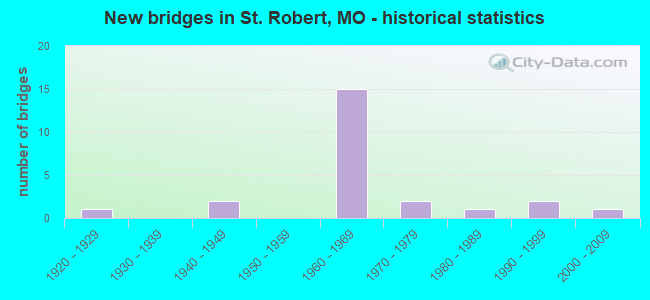
- New bridges - historical statistics
- 11920-1929
- 21940-1949
- 151960-1969
- 21970-1979
- 11980-1989
- 21990-1999
- 12000-2009

- Reconstructed bridges - Historical Statistics
- 51980-1989
- 01990-1999
- 12000-2009


- Bridge Condition - Deck
- 27.3%Good
- 63.6%Satisfactory
- 9.1%Fair

- Bridge Condition - Superstructure
- 18.2%Very good
- 9.1%Good
- 63.6%Satisfactory
- 9.1%Fair

- Bridge Condition - Substructure
- 18.2%Very good
- 18.2%Good
- 45.5%Satisfactory
- 18.2%Fair

- Bridge Condition - Channel
- 14.3%Good
- 57.1%Satisfactory
- 14.3%Fair
- 14.3%Poor
Find on map >> Show street view
Structure Number: 11937, Location: S 36 T 37 N R 11 W (Lat: 37.892211, Lng: -92.081364), Route carried "on" structure: State highway 28, Year Built: 2001, Status: Open, Structure Length: 23.32m (76.51ft), Average Daily Traffic: 5,321 (year 2021), Truck Traffic: 4%, Average Future Daily Traffic: 8,514 (year 2041), Design Load: HS 20, Features Intersected: GASCONADE RVR
Minimum Vertical Clearance: 30+ m (98+ ft), Kilometerpoint: 8.027, Lanes on structure: 2, Base Highway Network: Yes, Owner: State Highway Agency, Approaching Roadway Width: 12.2m (40.0ft), Skew: 1 degrees, Material/Design: Prestressed concrete continuous, Design/Construction: Tee Beam, Number Of Spans In Main Unit: 3, Number Of Approach Spans: 5, Length of Maximum Span: 37.1m (121.7ft), Curb-To-Curb Width: 11.8m (38.7ft), Out-to-Out Width: 12.6m (41.3ft)
Condition: Deck: Good, Superstructure: Very good, Substructure: Good, Channel: Good, Operating Rating: 80.1 metric tons, Method Used To Determine Operating Rating: Load Factor (LF), Inventory Rating: 35.1 metric tons, Method Used To Determine Inventory Rating: Load Factor (LF), Structural Evaluation: Better than present minimum criteria, Deck Geometry: Somewhat better than minimum adequacy, Waterway Adequacy: Equal to present desirable criteria, Approach Roadway Alignment: Equal to present desirable criteria, Designated Inspection Frequency: Every 24 months, Inspection Date: October 2021, Deck Structure Type: Concrete Cast-file-Place, Wearing Surface/Protective System: Wearing Surface: Monolithic Concrete, Deck Protection: Internally Sealed
Find on map >> Show street view
Structure Number: 15735, Location: S 28 T 37 N R 11 W (Lat: 37.908844, Lng: -92.132267), Route carried "on" structure: County highway 98, Year Built: 1987, Status: Open, Structure Length: 11.28m (37.01ft), Average Daily Traffic: 100 (year 2020), Truck Traffic: 10%, Average Future Daily Traffic: 130 (year 2040), Design Load: H 15, Features Intersected: GASCONADE RVR, Facility Carried by Structure: HOLTZMAN DR
Minimum Vertical Clearance: 30+ m (98+ ft), Kilometerpoint: 0.322, Lanes on structure: 2, Owner: County Highway Agency, Approaching Roadway Width: 7.3m (24.0ft), Material/Design: Steel, Design/Construction: Stringer/Multi-beam, Number Of Spans In Main Unit: 4, Length of Maximum Span: 38.1m (125.0ft), Curb or Sidewalk Widths: Left: 0.2m (0.7ft), Right: 0.2m (0.7ft), Curb-To-Curb Width: 7.3m (24.0ft), Out-to-Out Width: 8.1m (26.6ft)
Condition: Deck: Good, Superstructure: Very good, Substructure: Fair, Channel: Fair, Operating Rating: 49.5 metric tons, Method Used To Determine Operating Rating: Allowable Stress (AS), Inventory Rating: 16.2 metric tons, Method Used To Determine Inventory Rating: Allowable Stress (AS), Structural Evaluation: Somewhat better than minimum adequacy, Deck Geometry: Equal to present minimum criteria, Waterway Adequacy: Better than present minimum criteria, Approach Roadway Alignment: Equal to present minimum criteria, Designated Inspection Frequency: Every 24 months, Underwater Inspection Frequency: Every 60 months, Inspection Date: January 2022, Underwater Inspection Date: July 2018, Deck Structure Type: Concrete Cast-file-Place, Wearing Surface/Protective System: Wearing Surface: Monolithic Concrete
Find on map >> Show street view
Structure Number: 16497, Location: S 25 T 36 N R 11 W (Lat: 37.821039, Lng: -92.089278), Route carried "on" structure: County highway 122, Year Built: 1992, Status: Open, Structure Length: 2.04m (6.69ft), Average Daily Traffic: 50 (year 2020), Truck Traffic: 10%, Average Future Daily Traffic: 65 (year 2040), Features Intersected: STREAM, Facility Carried by Structure: TULSA ROAD
Minimum Vertical Clearance: 30+ m (98+ ft), Kilometerpoint: 2.897, Lanes on structure: 2, Owner: County Highway Agency, Approaching Roadway Width: 7.3m (24.0ft), Material/Design: Steel, Design/Construction: Stringer/Multi-beam, Number Of Spans In Main Unit: 1, Length of Maximum Span: 19.2m (63.0ft), Curb-To-Curb Width: 5.7m (18.7ft), Out-to-Out Width: 6.1m (20.0ft)
Condition: Deck: Satisfactory, Superstructure: Good, Substructure: Very good, Channel: Satisfactory, Operating Rating: 41.4 metric tons, Method Used To Determine Operating Rating: Allowable Stress (AS), Inventory Rating: 24.3 metric tons, Method Used To Determine Inventory Rating: Allowable Stress (AS), Structural Evaluation: Equal to present minimum criteria, Deck Geometry: Meets minimum limits, Waterway Adequacy: Better than present minimum criteria, Approach Roadway Alignment: Equal to present minimum criteria, Designated Inspection Frequency: Every 24 months, Inspection Date: January 2022, Deck Structure Type: Concrete Cast-file-Place, Wearing Surface/Protective System: Wearing Surface: Monolithic Concrete
Find on map >> Show street view
Structure Number: 16527, Location: S 35 T 36 N R 11 W (Lat: 37.806944, Lng: -92.110028), Route carried "on" structure: County highway 123, Year Built: 1996, Status: Open, Structure Length: 1.52m (4.99ft), Average Daily Traffic: 20 (year 2020), Truck Traffic: 10%, Average Future Daily Traffic: 26 (year 2040), Features Intersected: UNKNOWN BR, Facility Carried by Structure: TEXAS RD
Minimum Vertical Clearance: 30+ m (98+ ft), Kilometerpoint: 2.414, Lanes on structure: 2, Owner: County Highway Agency, Approaching Roadway Width: 4.3m (14.1ft), Material/Design: Steel, Design/Construction: Stringer/Multi-beam, Number Of Spans In Main Unit: 1, Length of Maximum Span: 14.6m (47.9ft), Curb-To-Curb Width: 5.6m (18.4ft), Out-to-Out Width: 5.9m (19.4ft)
Condition: Deck: Good, Superstructure: Satisfactory, Substructure: Very good, Channel: Satisfactory, Operating Rating: 52.2 metric tons, Method Used To Determine Operating Rating: Load Factor (LF), Inventory Rating: 31.5 metric tons, Method Used To Determine Inventory Rating: Load Factor (LF), Structural Evaluation: Equal to present minimum criteria, Deck Geometry: Meets minimum limits, Waterway Adequacy: Better than present minimum criteria, Approach Roadway Alignment: Equal to present minimum criteria, Designated Inspection Frequency: Every 24 months, Inspection Date: January 2022, Deck Structure Type: Concrete Cast-file-Place, Wearing Surface/Protective System: Wearing Surface: Integral Concrete
Find on map >> Show street view
Structure Number: 18976, Location: S 18 T 36 N R 10 W (Lat: 37.848331, Lng: -92.062367), Route carried "on" structure: County highway 206, Year Built: 1923, Year Reconstructed: 2014, Status: Posted for load, Structure Length: 17.95m (58.89ft), Average Daily Traffic: 100 (year 2020), Truck Traffic: 10%, Average Future Daily Traffic: 130 (year 2040), Features Intersected: BIG PINEY RVR, Facility Carried by Structure: TEAR DROP RD
Minimum Vertical Clearance: 4.27m (14.01ft), Kilometerpoint: 2.414, Lanes on structure: 2, Owner: County Highway Agency, Approaching Roadway Width: 7.6m (24.9ft), Material/Design: Steel, Design/Construction: Truss - Thru, Number Of Spans In Main Unit: 2, Number Of Approach Spans: 5, Length of Maximum Span: 49.1m (161.1ft), Curb-To-Curb Width: 5.9m (19.4ft), Out-to-Out Width: 6.5m (21.3ft)
Condition: Deck: Satisfactory, Superstructure: Satisfactory, Substructure: Fair, Channel: Poor, Operating Rating: 28.8 metric tons, Method Used To Determine Operating Rating: Load Factor (LF), Inventory Rating: 25.2 metric tons, Method Used To Determine Inventory Rating: Load Factor (LF), Structural Evaluation: Somewhat better than minimum adequacy, Deck Geometry: Meets minimum limits, Waterway Adequacy: Better than present minimum criteria, Approach Roadway Alignment: Equal to present minimum criteria, Bridge Posting: Required (Relationship of Operating Rating to Maximum Legal Load: 30.0 - 39.9% below), Designated Inspection Frequency: Every 24 months, Critical Feature Inspection Frequency: Every 24 months, Underwater Inspection Frequency: Every 60 months, Inspection Date: January 2022, Critical Feature Inspection Date: July 2020, Underwater Inspection Date: July 2018, Deck Structure Type: Concrete Cast-file-Place, Wearing Surface/Protective System: Wearing Surface: Monolithic Concrete, Deck Protection: Epoxy Coated Reinforcing
Find on map >> Show street view
Structure Number: 575, Location: S 29 T 36 N R 11 W (Lat: 37.824617, Lng: -92.167419), Route carried "on" structure: Business State highway 44, Year Built: 1961, Year Reconstructed: 1992, Status: Open, Structure Length: 13.08m (42.91ft), Average Daily Traffic: 7,667 (year 2021), Truck Traffic: 4%, Average Future Daily Traffic: 12,267 (year 2041), Design Load: H 20, Features Intersected: IS 44
Minimum Vertical Clearance: 30+ m (98+ ft), Kilometerpoint: 6.933, Lanes on structure: 2, Lanes under structure: 4, Owner: State Highway Agency, Approaching Roadway Width: 12.2m (40.0ft), Material/Design: Concrete continuous, Design/Construction: Box Beam or Girders - Single/Spread, Number Of Spans In Main Unit: 6, Length of Maximum Span: 26.5m (86.9ft), Curb or Sidewalk Widths: Left: 0.2m (0.7ft), Right: 0.2m (0.7ft), Curb-To-Curb Width: 8.8m (28.9ft), Out-to-Out Width: 9.7m (31.8ft)
Condition: Deck: Satisfactory, Superstructure: Satisfactory, Substructure: Satisfactory, Operating Rating: 57.6 metric tons, Method Used To Determine Operating Rating: Allowable Stress (AS), Inventory Rating: 27.9 metric tons, Method Used To Determine Inventory Rating: Allowable Stress (AS), Structural Evaluation: Equal to present minimum criteria, Deck Geometry: High priority of corrective action, Underclear: Meets minimum limits, Approach Roadway Alignment: Equal to present desirable criteria, Length Of Structure Improvement: 1.39m (4.56ft), Designated Inspection Frequency: Every 24 months, Inspection Date: October 2021, Bridge Improvement Cost: $1,079,000, Roadway Improvement Cost: $108,000, Total Project Cost: $1,618,000 ( Estimate for 2022), Deck Structure Type: Concrete Cast-file-Place, Wearing Surface/Protective System: Wearing Surface: Latex Concrete, Membrane: Built-up, Deck Protection: Internally Sealed
Find on map >> Show street view
Structure Number: 576, Location: S 29 T 36 N R 11 W (Lat: 37.824744, Lng: -92.167097), Route carried "on" structure: Business State highway 44, Year Built: 1961, Year Reconstructed: 1992, Status: Open, Structure Length: 13.08m (42.91ft), Average Daily Traffic: 6,002 (year 2021), Truck Traffic: 5%, Average Future Daily Traffic: 9,603 (year 2041), Design Load: H 20, Features Intersected: IS 44
Minimum Vertical Clearance: 30+ m (98+ ft), Kilometerpoint: 2.519, Lanes on structure: 2, Lanes under structure: 4, Owner: State Highway Agency, Approaching Roadway Width: 12.2m (40.0ft), Material/Design: Concrete continuous, Design/Construction: Box Beam or Girders - Single/Spread, Number Of Spans In Main Unit: 6, Length of Maximum Span: 26.5m (86.9ft), Curb or Sidewalk Widths: Left: 0.2m (0.7ft), Right: 0.2m (0.7ft), Curb-To-Curb Width: 8.8m (28.9ft), Out-to-Out Width: 9.7m (31.8ft)
Condition: Deck: Satisfactory, Superstructure: Satisfactory, Substructure: Satisfactory, Operating Rating: 57.6 metric tons, Method Used To Determine Operating Rating: Allowable Stress (AS), Inventory Rating: 27.9 metric tons, Method Used To Determine Inventory Rating: Allowable Stress (AS), Structural Evaluation: Equal to present minimum criteria, Deck Geometry: High priority of corrective action, Underclear: Meets minimum limits, Approach Roadway Alignment: Equal to present desirable criteria, Length Of Structure Improvement: 1.39m (4.56ft), Designated Inspection Frequency: Every 24 months, Inspection Date: October 2021, Bridge Improvement Cost: $1,079,000, Roadway Improvement Cost: $108,000, Total Project Cost: $1,618,000 ( Estimate for 2022), Deck Structure Type: Concrete Cast-file-Place, Wearing Surface/Protective System: Wearing Surface: Latex Concrete, Membrane: Built-up, Deck Protection: Internally Sealed
Find on map >> Show street view
Structure Number: 577, Location: S 28 T 36 N R 11 W (Lat: 37.823617, Lng: -92.143356), Route carried "on" structure: State highway Y, Year Built: 1961, Year Reconstructed: 1987, Status: Open, Structure Length: 6.74m (22.11ft), Average Daily Traffic: 8,108 (year 2021), Truck Traffic: 11%, Average Future Daily Traffic: 12,973 (year 2041), Design Load: H 20, Features Intersected: IS 44
Minimum Vertical Clearance: 30+ m (98+ ft), Kilometerpoint: 0.032, Lanes on structure: 2, Lanes under structure: 4, Base Highway Network: Yes, Owner: State Highway Agency, Approaching Roadway Width: 7.3m (24.0ft), Skew: 1 degrees, Material/Design: Concrete continuous, Design/Construction: Slab, Number Of Spans In Main Unit: 4, Length of Maximum Span: 19.8m (65.0ft), Curb or Sidewalk Widths: Left: 0.2m (0.7ft), Right: 0.2m (0.7ft), Curb-To-Curb Width: 11.9m (39.0ft), Out-to-Out Width: 12.7m (41.7ft)
Condition: Deck: Satisfactory, Superstructure: Satisfactory, Substructure: Satisfactory, Operating Rating: 51.3 metric tons, Method Used To Determine Operating Rating: Load Factor (LF), Inventory Rating: 30.6 metric tons, Method Used To Determine Inventory Rating: Load Factor (LF), Structural Evaluation: Equal to present minimum criteria, Deck Geometry: Better than present minimum criteria, Underclear: High priority of corrective action, Approach Roadway Alignment: Equal to present desirable criteria, Designated Inspection Frequency: Every 24 months, Inspection Date: October 2021, Deck Structure Type: Concrete Cast-file-Place, Wearing Surface/Protective System: Wearing Surface: Low Slump Concrete, Deck Protection: Internally Sealed
Find on map >> Show street view
Structure Number: 578, Location: S 28 T 36 N R 11 W (Lat: 37.823406, Lng: -92.143611), Route carried "on" structure: State highway Y, Year Built: 1961, Year Reconstructed: 1987, Status: Open, Structure Length: 6.74m (22.11ft), Average Daily Traffic: 7,544 (year 2021), Truck Traffic: 4%, Average Future Daily Traffic: 12,070 (year 2041), Design Load: H 20, Features Intersected: IS 44
Minimum Vertical Clearance: 30+ m (98+ ft), Kilometerpoint: 10.664, Lanes on structure: 2, Lanes under structure: 4, Base Highway Network: Yes, Owner: State Highway Agency, Approaching Roadway Width: 7.3m (24.0ft), Skew: 1 degrees, Material/Design: Concrete continuous, Design/Construction: Slab, Number Of Spans In Main Unit: 4, Length of Maximum Span: 19.8m (65.0ft), Curb or Sidewalk Widths: Left: 0.2m (0.7ft), Right: 0.2m (0.7ft), Curb-To-Curb Width: 11.9m (39.0ft), Out-to-Out Width: 12.7m (41.7ft)
Condition: Deck: Satisfactory, Superstructure: Satisfactory, Substructure: Satisfactory, Operating Rating: 51.3 metric tons, Method Used To Determine Operating Rating: Load Factor (LF), Inventory Rating: 30.6 metric tons, Method Used To Determine Inventory Rating: Load Factor (LF), Structural Evaluation: Equal to present minimum criteria, Deck Geometry: Better than present minimum criteria, Underclear: Meets minimum limits, Approach Roadway Alignment: Equal to present desirable criteria, Designated Inspection Frequency: Every 24 months, Inspection Date: October 2021, Deck Structure Type: Concrete Cast-file-Place, Wearing Surface/Protective System: Wearing Surface: Low Slump Concrete, Membrane: Built-up, Deck Protection: Internally Sealed
Find on map >> Show street view
Structure Number: 579, Location: S 23 T 36 N R 11 W (Lat: 37.834583, Lng: -92.099067), Route carried "on" structure: State highway 28, Year Built: 1961, Year Reconstructed: 1987, Status: Open, Structure Length: 6.19m (20.31ft), Average Daily Traffic: 5,321 (year 2021), Truck Traffic: 4%, Average Future Daily Traffic: 8,514 (year 2041), Design Load: H 15, Features Intersected: IS 44
Minimum Vertical Clearance: 30+ m (98+ ft), Kilometerpoint: 0.092, Lanes on structure: 2, Lanes under structure: 4, Owner: State Highway Agency, Approaching Roadway Width: 7.3m (24.0ft), Material/Design: Concrete continuous, Design/Construction: Slab, Number Of Spans In Main Unit: 4, Length of Maximum Span: 17.1m (56.1ft), Curb-To-Curb Width: 7.6m (24.9ft), Out-to-Out Width: 8.4m (27.6ft)
Condition: Deck: Satisfactory, Superstructure: Satisfactory, Substructure: Good, Operating Rating: 56.7 metric tons, Method Used To Determine Operating Rating: Allowable Stress (AS), Inventory Rating: 32.4 metric tons, Method Used To Determine Inventory Rating: Allowable Stress (AS), Structural Evaluation: Equal to present minimum criteria, Deck Geometry: High priority of replacement, Underclear: Meets minimum limits, Approach Roadway Alignment: Equal to present minimum criteria, Length Of Structure Improvement: 0.72m (2.36ft), Designated Inspection Frequency: Every 24 months, Inspection Date: October 2021, Bridge Improvement Cost: $616,000, Roadway Improvement Cost: $62,000, Total Project Cost: $924,000 ( Estimate for 2022), Deck Structure Type: Concrete Cast-file-Place, Wearing Surface/Protective System: Wearing Surface: Low Slump Concrete, Membrane: Built-up
Find on map >> Show street view
Structure Number: 6047, Location: S 18 T 36 N R 10 W (Lat: 37.849750, Lng: -92.071506), Route carried "on" structure: State highway Z, Year Built: 1942, Status: Open, Structure Length: 19.45m (63.81ft), Average Daily Traffic: 225 (year 2021), Truck Traffic: 4%, Average Future Daily Traffic: 338 (year 2041), Design Load: H 20, Features Intersected: BIG PINEY RVR
Minimum Vertical Clearance: 30+ m (98+ ft), Kilometerpoint: 7.644, Lanes on structure: 4, Owner: State Highway Agency, Approaching Roadway Width: 13.4m (44.0ft), Skew: 20 degrees, Material/Design: Concrete continuous, Design/Construction: Arch - Deck, Number Of Spans In Main Unit: 3, Number Of Approach Spans: 5, Length of Maximum Span: 50.3m (165.0ft), Curb-To-Curb Width: 17.7m (58.1ft), Out-to-Out Width: 19.0m (62.3ft)
Condition: Deck: Fair, Superstructure: Fair, Substructure: Satisfactory, Channel: Satisfactory, Operating Rating: 28.8 metric tons, Method Used To Determine Operating Rating: Load Factor (LF), Inventory Rating: 17.1 metric tons, Method Used To Determine Inventory Rating: Load Factor (LF), Structural Evaluation: Somewhat better than minimum adequacy, Deck Geometry: Somewhat better than minimum adequacy, Waterway Adequacy: Equal to present desirable criteria, Approach Roadway Alignment: Equal to present minimum criteria, Designated Inspection Frequency: Every 24 months, Inspection Date: October 2021, Deck Structure Type: Concrete Cast-file-Place, Wearing Surface/Protective System: Wearing Surface: Bituminous
Find on map >> Show street view
Structure Number: 6054, Location: S 8 T 36 N R 10 W (Lat: 37.856564, Lng: -92.046475), Route carried "on" structure: State highway Z, Year Built: 1944, Status: Open, Structure Length: 1.07m (3.51ft), Average Daily Traffic: 225 (year 2021), Truck Traffic: 4%, Average Future Daily Traffic: 338 (year 2041), Design Load: H 20, Features Intersected: HOOKER BR
Minimum Vertical Clearance: 30+ m (98+ ft), Kilometerpoint: 10.752, Lanes on structure: 4, Owner: State Highway Agency, Approaching Roadway Width: 32.9m (107.9ft), Skew: 24 degrees, Material/Design: Concrete continuous, Design/Construction: Culvert, Number Of Spans In Main Unit: 2, Length of Maximum Span: 3.7m (12.1ft)
Condition: Channel: Satisfactory, Culverts: Satisfactory, Operating Rating: 72.0 metric tons, Method Used To Determine Operating Rating: Load Factor (LF), Inventory Rating: 43.2 metric tons, Method Used To Determine Inventory Rating: Load Factor (LF), Structural Evaluation: Equal to present minimum criteria, Waterway Adequacy: Equal to present minimum criteria, Approach Roadway Alignment: Equal to present desirable criteria, Designated Inspection Frequency: Every 24 months, Inspection Date: October 2021
Find on map >> Show street view
Structure Number: 2631, Location: S 7 T 36 N R 10 W (Lat: 37.861828, Lng: -92.061600), Route carried "under" structure: County highway , Year Built: 1976, Structure Length: 0. m, Average Daily Traffic: 166 (year 2021), Truck Traffic: 10%, Features Intersected: CRD TROPHY LN, Facility Carried by Structure: IS 44 E
Minimum Vertical Clearance: 8.23m (27.00ft), Kilometerpoint: 1.899, Lanes on structure: 2, Lanes under structure: 2, Material/Design: Steel continuous, Design/Construction: Stringer/Multi-beam, Length of Maximum Span: 28.6m (93.8ft)
Find on map >> Show street view
Structure Number: 2632, Location: S 7 T 36 N R 10 W (Lat: 37.862061, Lng: -92.061717), Route carried "under" structure: County highway , Year Built: 1976, Structure Length: 0. m, Average Daily Traffic: 166 (year 2021), Truck Traffic: 10%, Features Intersected: CRD TROPHY LN, Facility Carried by Structure: IS 44 W
Minimum Vertical Clearance: 8.23m (27.00ft), Kilometerpoint: 1.872, Lanes on structure: 2, Lanes under structure: 2, Material/Design: Steel continuous, Design/Construction: Stringer/Multi-beam, Length of Maximum Span: 28.6m (93.8ft)
Find on map >> Show street view
Structure Number: 575, Location: S 29 T 36 N R 11 W (Lat: 37.824617, Lng: -92.167419), Route carried "under" structure: Interstate 44, Year Built: 1961, Structure Length: 0. m, Average Daily Traffic: 17,715 (year 2021), Truck Traffic: 30%, Features Intersected: IS 44
Minimum Vertical Clearance: 5.08m (16.67ft), Kilometerpoint: 257.227, Lanes on structure: 2, Lanes under structure: 2, Material/Design: Concrete continuous, Design/Construction: Box Beam or Girders - Single/Spread, Length of Maximum Span: 26.5m (86.9ft)
Find on map >> Show street view
Structure Number: 575, Location: S 29 T 36 N R 11 W (Lat: 37.824617, Lng: -92.167419), Route carried "under" structure: Interstate 44, Year Built: 1961, Structure Length: 0. m, Average Daily Traffic: 16,238 (year 2021), Truck Traffic: 30%, Features Intersected: IS 44
Minimum Vertical Clearance: 5.18m (16.99ft), Kilometerpoint: 214.713, Lanes on structure: 2, Lanes under structure: 2, Material/Design: Concrete continuous, Design/Construction: Box Beam or Girders - Single/Spread, Length of Maximum Span: 26.5m (86.9ft)
Find on map >> Show street view
Structure Number: 576, Location: S 29 T 36 N R 11 W (Lat: 37.824744, Lng: -92.167097), Route carried "under" structure: Interstate 44, Year Built: 1961, Structure Length: 0. m, Average Daily Traffic: 18,745 (year 2021), Truck Traffic: 30%, Features Intersected: IS 44
Minimum Vertical Clearance: 5.18m (16.99ft), Kilometerpoint: 257.278, Lanes on structure: 2, Lanes under structure: 2, Material/Design: Concrete continuous, Design/Construction: Box Beam or Girders - Single/Spread, Length of Maximum Span: 26.5m (86.9ft)
Find on map >> Show street view
Structure Number: 576, Location: S 29 T 36 N R 11 W (Lat: 37.824744, Lng: -92.167097), Route carried "under" structure: Interstate 44, Year Built: 1961, Structure Length: 0. m, Average Daily Traffic: 21,306 (year 2021), Truck Traffic: 30%, Features Intersected: IS 44
Minimum Vertical Clearance: 5.13m (16.83ft), Kilometerpoint: 214.666, Lanes on structure: 2, Lanes under structure: 2, Material/Design: Concrete continuous, Design/Construction: Box Beam or Girders - Single/Spread, Length of Maximum Span: 26.5m (86.9ft)
Find on map >> Show street view
Structure Number: 577, Location: S 28 T 36 N R 11 W (Lat: 37.823617, Lng: -92.143356), Route carried "under" structure: Interstate 44, Year Built: 1961, Structure Length: 0. m, Average Daily Traffic: 18,745 (year 2021), Truck Traffic: 30%, Features Intersected: IS 44, Facility Carried by Structure: RT Y N
Minimum Vertical Clearance: 5.18m (16.99ft), Kilometerpoint: 259.395, Lanes on structure: 2, Lanes under structure: 2, Material/Design: Concrete continuous, Design/Construction: Slab, Length of Maximum Span: 19.8m (65.0ft)
Find on map >> Show street view
Structure Number: 577, Location: S 28 T 36 N R 11 W (Lat: 37.823617, Lng: -92.143356), Route carried "under" structure: Interstate 44, Year Built: 1961, Structure Length: 0. m, Average Daily Traffic: 20,709 (year 2021), Truck Traffic: 29%, Features Intersected: IS 44, Facility Carried by Structure: RT Y N
Minimum Vertical Clearance: 4.88m (16.01ft), Kilometerpoint: 212.534, Lanes on structure: 2, Lanes under structure: 2, Material/Design: Concrete continuous, Design/Construction: Slab, Length of Maximum Span: 19.8m (65.0ft)
Find on map >> Show street view
Structure Number: 578, Location: S 28 T 36 N R 11 W (Lat: 37.823406, Lng: -92.143611), Route carried "under" structure: Interstate 44, Year Built: 1961, Structure Length: 0. m, Average Daily Traffic: 21,306 (year 2021), Truck Traffic: 30%, Features Intersected: IS 44, Facility Carried by Structure: RT Y S
Minimum Vertical Clearance: 4.88m (16.01ft), Kilometerpoint: 212.563, Lanes on structure: 2, Lanes under structure: 2, Material/Design: Concrete continuous, Design/Construction: Slab, Length of Maximum Span: 19.8m (65.0ft)
Find on map >> Show street view
Structure Number: 578, Location: S 28 T 36 N R 11 W (Lat: 37.823406, Lng: -92.143611), Route carried "under" structure: Interstate 44, Year Built: 1961, Structure Length: 0. m, Average Daily Traffic: 18,745 (year 2021), Truck Traffic: 30%, Features Intersected: IS 44, Facility Carried by Structure: RT Y S
Minimum Vertical Clearance: 4.95m (16.24ft), Kilometerpoint: 259.364, Lanes on structure: 2, Lanes under structure: 2, Material/Design: Concrete continuous, Design/Construction: Slab, Length of Maximum Span: 19.8m (65.0ft)
Find on map >> Show street view
Structure Number: 579, Location: S 23 T 36 N R 11 W (Lat: 37.834583, Lng: -92.099067), Route carried "under" structure: Interstate 44, Year Built: 1961, Structure Length: 0. m, Average Daily Traffic: 20,709 (year 2021), Truck Traffic: 29%, Features Intersected: IS 44, Facility Carried by Structure: MO 28 E
Minimum Vertical Clearance: 5.18m (16.99ft), Kilometerpoint: 263.671, Lanes on structure: 2, Lanes under structure: 2, Material/Design: Concrete continuous, Design/Construction: Slab, Length of Maximum Span: 17.1m (56.1ft)
Find on map >> Show street view
Structure Number: 579, Location: S 23 T 36 N R 11 W (Lat: 37.834583, Lng: -92.099067), Route carried "under" structure: Interstate 44, Year Built: 1961, Structure Length: 0. m, Average Daily Traffic: 14,136 (year 2021), Truck Traffic: 29%, Features Intersected: IS 44, Facility Carried by Structure: MO 28 E
Minimum Vertical Clearance: 4.67m (15.32ft), Kilometerpoint: 208.267, Lanes on structure: 2, Lanes under structure: 2, Material/Design: Concrete continuous, Design/Construction: Slab, Length of Maximum Span: 17.1m (56.1ft)