Bridge Statistics for Stafford, Texas (TX)
Condition, Traffic, Stress, Structural Evaluation, Project Costs
- National Bridge Inventory (NBI) Statistics
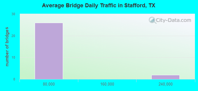
- 28Number of bridges
- 338ft / 103mTotal length
- $11,000Total costs
- 739,040Total average daily traffic
- 54,174Total average daily truck traffic
- National Bridge Inventory (NBI) Registered Bridges for Stafford
- No street view available for this location

- New bridges - historical statistics
- 11960-1969
- 31980-1989
- 21990-1999
- 212000-2009
- 12010-2019
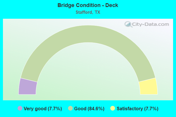
- Bridge Condition - Deck
- 7.7%Very good
- 84.6%Good
- 7.7%Satisfactory
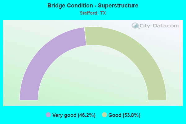
- Bridge Condition - Superstructure
- 46.2%Very good
- 53.8%Good
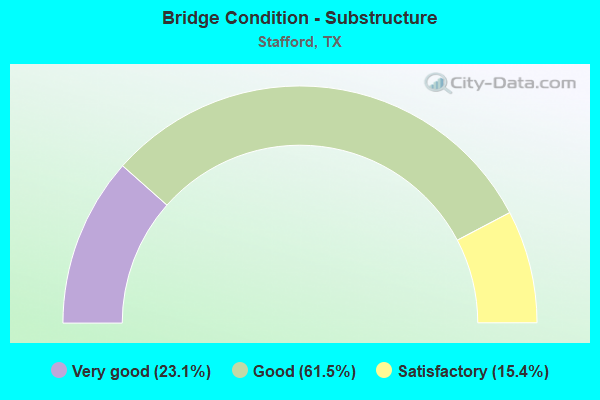
- Bridge Condition - Substructure
- 23.1%Very good
- 61.5%Good
- 15.4%Satisfactory
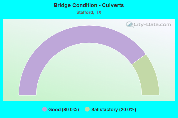
- Bridge Condition - Culverts
- 80.0%Good
- 20.0%Satisfactory
Find on map >> Show street view
Structure Number: 120800002708021, Location: US 90A AT DULLES/KIRKWOOD (Lat: 29.627469, Lng: -95.582589), Route carried "on" structure: Alternate State highway 90, Year Built: 2008, Status: Open, Structure Length: 18.93m (62.11ft), Average Daily Traffic: 22,000 (year 2010), Truck Traffic: 10%, Average Future Daily Traffic: 25,000 (year 2030), Design Load: HS 20, Features Intersected: DULLES/KIRKWOOD
Minimum Vertical Clearance: 30+ m (98+ ft), Kilometerpoint: 0.002, Lanes on structure: 6, Lanes under structure: 10, Owner: State Highway Agency, Approaching Roadway Width: 23.8m (78.1ft), Skew: 29 degrees, Material/Design: Prestressed concrete, Design/Construction: Stringer/Multi-beam, Number Of Spans In Main Unit: 6, Length of Maximum Span: 36.9m (121.1ft), Curb-To-Curb Width: 23.7m (77.8ft), Out-to-Out Width: 28.7m (94.2ft)
Condition: Deck: Good, Superstructure: Good, Substructure: Satisfactory, Operating Rating: 54.4 metric tons, Method Used To Determine Operating Rating: Assigned rating based on Load Factor Design (LFD) reported in metric tons, Inventory Rating: 32.7 metric tons, Method Used To Determine Inventory Rating: Assigned rating based on Load Factor Design (LFD) reported in metric tons, Structural Evaluation: Equal to present minimum criteria, Deck Geometry: Somewhat better than minimum adequacy, Underclear: Meets minimum limits, Approach Roadway Alignment: Equal to present desirable criteria, Designated Inspection Frequency: Every 24 months, Inspection Date: December 2020, Deck Structure Type: Concrete Precast Panels, Wearing Surface/Protective System: Wearing Surface: Monolithic Concrete
Find on map >> Show street view
Structure Number: 120800002708374, Location: 1.8 Mi E of US 59 (Lat: 29.618700, Lng: -95.564872), Route carried "on" structure: Alternate State highway 90, Year Built: 2008, Status: Open, Structure Length: 4.48m (14.70ft), Average Daily Traffic: 13,500 (year 2010), Truck Traffic: 10%, Average Future Daily Traffic: 15,000 (year 2030), Design Load: HS 20, Features Intersected: FM 1092
Minimum Vertical Clearance: 30+ m (98+ ft), Kilometerpoint: 0.002, Lanes on structure: 6, Lanes under structure: 4, Owner: State Highway Agency, Approaching Roadway Width: 28.0m (91.9ft), Skew: 4 degrees, Material/Design: Prestressed concrete, Design/Construction: Box Beam or Girders - Multiple, Number Of Spans In Main Unit: 2, Length of Maximum Span: 22.3m (73.2ft), Curb or Sidewalk Widths: Left: 7.0m (23.0ft), Right: 1.6m (5.2ft), Curb-To-Curb Width: 27.9m (91.5ft), Out-to-Out Width: 60.7m (199.1ft)
Condition: Deck: Good, Superstructure: Good, Substructure: Good, Operating Rating: 54.4 metric tons, Method Used To Determine Operating Rating: Assigned rating based on Load Factor Design (LFD) reported in metric tons, Inventory Rating: 32.7 metric tons, Method Used To Determine Inventory Rating: Assigned rating based on Load Factor Design (LFD) reported in metric tons, Structural Evaluation: Better than present minimum criteria, Deck Geometry: Superior to present desirable criteria, Underclear: Meets minimum limits, Approach Roadway Alignment: Equal to present desirable criteria, Designated Inspection Frequency: Every 24 months, Inspection Date: October 2020, Deck Structure Type: Concrete Cast-file-Place
Find on map >> Show street view
Structure Number: 120800002708375, Location: 1.8 Mi E of US 59 (Lat: 29.619361, Lng: -95.564519), Route carried "on" structure: Alternate State highway 90, Year Built: 2008, Status: Open, Structure Length: 3.78m (12.40ft), Average Daily Traffic: 13,500 (year 2010), Truck Traffic: 10%, Average Future Daily Traffic: 15,000 (year 2030), Design Load: HS 20, Features Intersected: FM 1092
Minimum Vertical Clearance: 30+ m (98+ ft), Kilometerpoint: 0.002, Lanes on structure: 5, Lanes under structure: 4, Owner: State Highway Agency, Approaching Roadway Width: 19.5m (64.0ft), Skew: 2 degrees, Material/Design: Prestressed concrete, Design/Construction: Box Beam or Girders - Multiple, Number Of Spans In Main Unit: 2, Length of Maximum Span: 18.9m (62.0ft), Curb or Sidewalk Widths: Left: 1.3m (4.3ft), Right: 1.5m (4.9ft), Curb-To-Curb Width: 19.5m (64.0ft), Out-to-Out Width: 24.1m (79.1ft)
Condition: Deck: Good, Superstructure: Good, Substructure: Very good, Operating Rating: 54.4 metric tons, Method Used To Determine Operating Rating: Assigned rating based on Load Factor Design (LFD) reported in metric tons, Inventory Rating: 32.7 metric tons, Method Used To Determine Inventory Rating: Assigned rating based on Load Factor Design (LFD) reported in metric tons, Structural Evaluation: Better than present minimum criteria, Deck Geometry: Meets minimum limits, Underclear: Meets minimum limits, Approach Roadway Alignment: Equal to present desirable criteria, Designated Inspection Frequency: Every 24 months, Inspection Date: October 2020, Deck Structure Type: Concrete Cast-file-Place
Find on map >> Show street view
Structure Number: 120800002708376, Location: 1.8 Mi E of US 59 (Lat: 29.620072, Lng: -95.564789), Route carried "on" structure: Ramp State highway 90, Year Built: 2008, Status: Open, Structure Length: 3.78m (12.40ft), Average Daily Traffic: 6,000 (year 2010), Truck Traffic: 5%, Average Future Daily Traffic: 7,000 (year 2030), Design Load: HS 20, Features Intersected: FM 1092
Minimum Vertical Clearance: 30+ m (98+ ft), Kilometerpoint: 0.002, Lanes on structure: 1, Lanes under structure: 4, Owner: State Highway Agency, Approaching Roadway Width: 8.2m (26.9ft), Skew: 2 degrees, Material/Design: Prestressed concrete, Design/Construction: Box Beam or Girders - Multiple, Number Of Spans In Main Unit: 2, Length of Maximum Span: 18.9m (62.0ft), Curb or Sidewalk Widths: Left: 1.6m (5.2ft), Right: 1.7m (5.6ft), Curb-To-Curb Width: 8.2m (26.9ft), Out-to-Out Width: 12.4m (40.7ft)
Condition: Deck: Good, Superstructure: Very good, Substructure: Good, Operating Rating: 54.4 metric tons, Method Used To Determine Operating Rating: Assigned rating based on Load Factor Design (LFD) reported in metric tons, Inventory Rating: 32.7 metric tons, Method Used To Determine Inventory Rating: Assigned rating based on Load Factor Design (LFD) reported in metric tons, Structural Evaluation: Better than present minimum criteria, Deck Geometry: Superior to present desirable criteria, Underclear: Meets minimum limits, Approach Roadway Alignment: Equal to present desirable criteria, Designated Inspection Frequency: Every 24 months, Inspection Date: October 2020, Deck Structure Type: Concrete Cast-file-Place
Find on map >> Show street view
Structure Number: 120800002708378, Location: 2.4 Mi E of US 59 (Lat: 29.614803, Lng: -95.556964), Route carried "on" structure: Alternate State highway 90, Year Built: 2008, Status: Open, Structure Length: 2.53m (8.30ft), Average Daily Traffic: 6,000 (year 2010), Truck Traffic: 10%, Average Future Daily Traffic: 7,000 (year 2030), Design Load: HS 20, Features Intersected: Stafford Rd
Minimum Vertical Clearance: 30+ m (98+ ft), Kilometerpoint: 0.002, Lanes on structure: 5, Lanes under structure: 4, Owner: State Highway Agency, Approaching Roadway Width: 23.2m (76.1ft), Skew: 1 degrees, Material/Design: Prestressed concrete, Design/Construction: Box Beam or Girders - Multiple, Number Of Spans In Main Unit: 1, Length of Maximum Span: 25.3m (83.0ft), Curb or Sidewalk Widths: Left: 1.8m (5.9ft), Right: 1.1m (3.6ft), Curb-To-Curb Width: 23.2m (76.1ft), Out-to-Out Width: 34.2m (112.2ft)
Condition: Deck: Good, Superstructure: Good, Substructure: Very good, Operating Rating: 54.4 metric tons, Method Used To Determine Operating Rating: Assigned rating based on Load Factor Design (LFD) reported in metric tons, Inventory Rating: 32.7 metric tons, Method Used To Determine Inventory Rating: Assigned rating based on Load Factor Design (LFD) reported in metric tons, Structural Evaluation: Better than present minimum criteria, Deck Geometry: Better than present minimum criteria, Underclear: Meets minimum limits, Approach Roadway Alignment: Equal to present desirable criteria, Length Of Structure Improvement: 2.53m (8.30ft), Designated Inspection Frequency: Every 24 months, Inspection Date: November 2020, Bridge Improvement Cost: $9,000, Roadway Improvement Cost: $2,000, Total Project Cost: $11,000, Deck Structure Type: Concrete Cast-file-Place
Find on map >> Show street view
Structure Number: 120800002708379, Location: 2.4 Mi E of US 59 (Lat: 29.616036, Lng: -95.556931), Route carried "on" structure: Alternate State highway 90, Year Built: 2008, Status: Open, Structure Length: 2.53m (8.30ft), Average Daily Traffic: 6,000 (year 2010), Truck Traffic: 10%, Average Future Daily Traffic: 7,000 (year 2030), Design Load: HS 20, Features Intersected: Stafford Rd
Minimum Vertical Clearance: 30+ m (98+ ft), Kilometerpoint: 0.002, Lanes on structure: 5, Lanes under structure: 4, Owner: State Highway Agency, Approaching Roadway Width: 19.5m (64.0ft), Skew: 1 degrees, Material/Design: Prestressed concrete, Design/Construction: Box Beam or Girders - Multiple, Number Of Spans In Main Unit: 1, Length of Maximum Span: 25.3m (83.0ft), Curb or Sidewalk Widths: Left: 1.2m (3.9ft), Right: 1.6m (5.2ft), Curb-To-Curb Width: 19.5m (64.0ft), Out-to-Out Width: 25.8m (84.6ft)
Condition: Deck: Good, Superstructure: Good, Substructure: Good, Operating Rating: 54.4 metric tons, Method Used To Determine Operating Rating: Assigned rating based on Load Factor Design (LFD) reported in metric tons, Inventory Rating: 32.7 metric tons, Method Used To Determine Inventory Rating: Assigned rating based on Load Factor Design (LFD) reported in metric tons, Structural Evaluation: Better than present minimum criteria, Deck Geometry: Meets minimum limits, Underclear: Meets minimum limits, Approach Roadway Alignment: Equal to present desirable criteria, Designated Inspection Frequency: Every 24 months, Inspection Date: November 2020, Deck Structure Type: Concrete Cast-file-Place
Find on map >> Show street view
Structure Number: 12080000270838, Location: 2.4 Mi E of US 59 (Lat: 29.616664, Lng: -95.556908), Route carried "on" structure: Ramp State highway 90, Year Built: 2008, Status: Open, Structure Length: 2.56m (8.40ft), Average Daily Traffic: 36,000 (year 2010), Truck Traffic: 5%, Average Future Daily Traffic: 39,600 (year 2030), Design Load: HS 20, Features Intersected: Stafford Rd
Minimum Vertical Clearance: 30+ m (98+ ft), Kilometerpoint: 0.002, Lanes on structure: 1, Lanes under structure: 4, Base Highway Network: Yes, Owner: State Highway Agency, Approaching Roadway Width: 7.3m (24.0ft), Skew: 1 degrees, Material/Design: Prestressed concrete, Design/Construction: Box Beam or Girders - Multiple, Number Of Spans In Main Unit: 1, Length of Maximum Span: 25.6m (84.0ft), Curb or Sidewalk Widths: Left: 1.6m (5.2ft), Right: 1.8m (5.9ft), Curb-To-Curb Width: 7.3m (24.0ft), Out-to-Out Width: 14.1m (46.3ft)
Condition: Deck: Good, Superstructure: Very good, Substructure: Good, Operating Rating: 54.4 metric tons, Method Used To Determine Operating Rating: Assigned rating based on Load Factor Design (LFD) reported in metric tons, Inventory Rating: 32.7 metric tons, Method Used To Determine Inventory Rating: Assigned rating based on Load Factor Design (LFD) reported in metric tons, Structural Evaluation: Better than present minimum criteria, Deck Geometry: Better than present minimum criteria, Underclear: Meets minimum limits, Approach Roadway Alignment: Equal to present desirable criteria, Designated Inspection Frequency: Every 24 months, Inspection Date: November 2020, Deck Structure Type: Concrete Cast-file-Place
Find on map >> Show street view
Structure Number: 120800002712289, Location: 1.5 MI NE OF US 90A (Lat: 29.638736, Lng: -95.581444), Route carried "on" structure: Interstate 69, Year Built: 2000, Status: Open, Structure Length: 10.67m (35.01ft), Average Daily Traffic: 183,561 (year 2020), Truck Traffic: 8%, Average Future Daily Traffic: 213,730 (year 2030), Design Load: HS 20, Features Intersected: KIRKWOOD DR
Minimum Vertical Clearance: 30+ m (98+ ft), Kilometerpoint: 1.395, Lanes on structure: 12, Lanes under structure: 10, Base Highway Network: Yes, Owner: State Highway Agency, Approaching Roadway Width: 56.7m (186.0ft), Skew: 32 degrees, Material/Design: Prestressed concrete, Design/Construction: Stringer/Multi-beam, Number Of Spans In Main Unit: 3, Length of Maximum Span: 39.6m (129.9ft), Curb-To-Curb Width: 56.9m (186.7ft), Out-to-Out Width: 58.5m (191.9ft)
Condition: Deck: Satisfactory, Superstructure: Very good, Substructure: Good, Operating Rating: 54.4 metric tons, Method Used To Determine Operating Rating: Assigned rating based on Load Factor Design (LFD) reported in metric tons, Inventory Rating: 32.7 metric tons, Method Used To Determine Inventory Rating: Assigned rating based on Load Factor Design (LFD) reported in metric tons, Structural Evaluation: Better than present minimum criteria, Deck Geometry: Superior to present desirable criteria, Underclear: High priority of corrective action, Approach Roadway Alignment: Equal to present desirable criteria, Designated Inspection Frequency: Every 24 months, Inspection Date: December 2020, Deck Structure Type: Concrete Precast Panels
Find on map >> Show street view
Structure Number: 12080000271229, Location: 1.5 MI NE OF US 90A (Lat: 29.643736, Lng: -95.576083), Route carried "on" structure: Interstate 69, Year Built: 2000, Status: Open, Structure Length: 8.53m (27.99ft), Average Daily Traffic: 183,561 (year 2020), Truck Traffic: 8%, Average Future Daily Traffic: 213,730 (year 2030), Design Load: HS 20, Features Intersected: W Airport Blvd
Minimum Vertical Clearance: 30+ m (98+ ft), Kilometerpoint: 0.653, Lanes on structure: 10, Lanes under structure: 10, Base Highway Network: Yes, Owner: State Highway Agency, Approaching Roadway Width: 56.7m (186.0ft), Skew: 10 degrees, Material/Design: Prestressed concrete, Design/Construction: Stringer/Multi-beam, Number Of Spans In Main Unit: 3, Length of Maximum Span: 36.6m (120.1ft), Curb-To-Curb Width: 56.9m (186.7ft), Out-to-Out Width: 58.5m (191.9ft)
Condition: Deck: Good, Superstructure: Very good, Substructure: Good, Operating Rating: 54.4 metric tons, Method Used To Determine Operating Rating: Assigned rating based on Load Factor Design (LFD) reported in metric tons, Inventory Rating: 32.7 metric tons, Method Used To Determine Inventory Rating: Assigned rating based on Load Factor Design (LFD) reported in metric tons, Structural Evaluation: Better than present minimum criteria, Deck Geometry: Superior to present desirable criteria, Underclear: Meets minimum limits, Approach Roadway Alignment: Equal to present desirable criteria, Designated Inspection Frequency: Every 24 months, Inspection Date: December 2020, Deck Structure Type: Concrete Precast Panels
Find on map >> Show street view
Structure Number: 120800002712291, Location: 1.5 Mi NE of US 90A (Lat: 29.645844, Lng: -95.573706), Route carried "on" structure: Ramp Interstate 69, Year Built: 2001, Status: Open, Structure Length: 30.18m (99.02ft), Average Daily Traffic: 10,000 (year 2013), Truck Traffic: 8%, Average Future Daily Traffic: 15,000 (year 2033), Design Load: HS 20, Features Intersected: IH 69 NB Airport On-Rp
Minimum Vertical Clearance: 30+ m (98+ ft), Kilometerpoint: 0.468, Lanes on structure: 1, Lanes under structure: 1, Base Highway Network: Yes, Owner: State Highway Agency, Approaching Roadway Width: 7.3m (24.0ft), Material/Design: Prestressed concrete, Design/Construction: Stringer/Multi-beam, Number Of Spans In Main Unit: 8, Length of Maximum Span: 38.1m (125.0ft), Curb-To-Curb Width: 7.2m (23.6ft), Out-to-Out Width: 8.2m (26.9ft)
Condition: Deck: Good, Superstructure: Very good, Substructure: Satisfactory, Operating Rating: 54.4 metric tons, Method Used To Determine Operating Rating: Assigned rating based on Load Factor Design (LFD) reported in metric tons, Inventory Rating: 32.7 metric tons, Method Used To Determine Inventory Rating: Assigned rating based on Load Factor Design (LFD) reported in metric tons, Structural Evaluation: Equal to present minimum criteria, Deck Geometry: Equal to present minimum criteria, Underclear: Somewhat better than minimum adequacy, Approach Roadway Alignment: Equal to present desirable criteria, Designated Inspection Frequency: Every 24 months, Inspection Date: December 2020, Deck Structure Type: Concrete Precast Panels
Find on map >> Show street view
Structure Number: 120800125701003, Location: 0.25 Mi S of Harris C/L (Lat: 29.642314, Lng: -95.565314), Route carried "on" structure: State highway 1092, Year Built: 1967, Year Reconstructed: 1990, Status: Open, Structure Length: 1.04m (3.41ft), Average Daily Traffic: 24,160 (year 2020), Truck Traffic: 4%, Average Future Daily Traffic: 36,020 (year 2033), Design Load: HS 20, Features Intersected: Drainage Ditch
Minimum Vertical Clearance: 30+ m (98+ ft), Kilometerpoint: 1.220, Lanes on structure: 7, Owner: State Highway Agency, Approaching Roadway Width: 26.2m (86.0ft), Material/Design: Concrete, Design/Construction: Culvert, Number Of Spans In Main Unit: 3, Length of Maximum Span: 3.0m (9.8ft)
Condition: Channel: Good, Culverts: Good, Operating Rating: 39.9 metric tons, Method Used To Determine Operating Rating: Load Factor (LF), Inventory Rating: 23.6 metric tons, Method Used To Determine Inventory Rating: Load Factor (LF), Structural Evaluation: Somewhat better than minimum adequacy, Waterway Adequacy: Equal to present minimum criteria, Approach Roadway Alignment: Equal to present desirable criteria, Designated Inspection Frequency: Every 24 months, Inspection Date: December 2020
Find on map >> Show street view
Structure Number: 120800125701008, Location: 3.0 MI N OF SH 6 (Lat: 29.610250, Lng: -95.564456), Route carried "on" structure: State highway 1092, Year Built: 1984, Status: Open, Structure Length: 3.96m (12.99ft), Average Daily Traffic: 39,170 (year 2018), Truck Traffic: 4%, Average Future Daily Traffic: 48,260 (year 2033), Design Load: HS 20, Features Intersected: Stafford Run Creek
Minimum Vertical Clearance: 30+ m (98+ ft), Kilometerpoint: 4.727, Lanes on structure: 5, Owner: State Highway Agency, Approaching Roadway Width: 18.3m (60.0ft), Skew: 3 degrees, Material/Design: Prestressed concrete, Design/Construction: Box Beam or Girders - Multiple, Number Of Spans In Main Unit: 3, Length of Maximum Span: 15.2m (49.9ft), Curb-To-Curb Width: 23.3m (76.4ft), Out-to-Out Width: 24.1m (79.1ft)
Condition: Deck: Very good, Superstructure: Good, Substructure: Good, Channel: Good, Operating Rating: 54.4 metric tons, Method Used To Determine Operating Rating: Assigned rating based on Load Factor Design (LFD) reported in metric tons, Inventory Rating: 32.7 metric tons, Method Used To Determine Inventory Rating: Assigned rating based on Load Factor Design (LFD) reported in metric tons, Structural Evaluation: Better than present minimum criteria, Deck Geometry: Better than present minimum criteria, Waterway Adequacy: Equal to present minimum criteria, Approach Roadway Alignment: Equal to present desirable criteria, Designated Inspection Frequency: Every 24 months, Inspection Date: September 2020, Deck Structure Type: Concrete Cast-file-Place, Wearing Surface/Protective System: Wearing Surface: Bituminous
Find on map >> Show street view
Structure Number: 120800NN0010005, Location: 0.00 MI W OF FM 1092 (Lat: 29.641036, Lng: -95.565700), Route carried "on" structure: City street , Year Built: 2019, Status: Open, Structure Length: 1.31m (4.30ft), Average Daily Traffic: 15,988 (year 2017), Average Future Daily Traffic: 44,875 (year 2047), Design Load: HL 93, Features Intersected: Drainage Ditch, Facility Carried by Structure: W Airport Blvd
Minimum Vertical Clearance: 30+ m (98+ ft), Kilometerpoint: 3.380, Lanes on structure: 7, Owner: Town or Township Highway Agency, Approaching Roadway Width: 26.8m (87.9ft), Material/Design: Concrete, Design/Construction: Culvert, Number Of Spans In Main Unit: 3, Length of Maximum Span: 3.7m (12.1ft), Curb or Sidewalk Widths: Left: 2.5m (8.2ft), Right: 2.0m (6.6ft), Curb-To-Curb Width: 33.8m (110.9ft), Out-to-Out Width: 37.2m (122.0ft)
Condition: Channel: Good, Culverts: Good, Operating Rating: 54.4 metric tons, Method Used To Determine Operating Rating: No rating analysis performed, Inventory Rating: 32.7 metric tons, Method Used To Determine Inventory Rating: No rating analysis performed, Structural Evaluation: Better than present minimum criteria, Deck Geometry: Superior to present desirable criteria, Waterway Adequacy: Superior to present desirable criteria, Approach Roadway Alignment: Equal to present desirable criteria, Designated Inspection Frequency: Every 24 months, Inspection Date: September 2021, Deck Structure Type: Concrete Cast-file-Place, Wearing Surface/Protective System: Wearing Surface: Monolithic Concrete
Find on map >> Show street view
Structure Number: 120800NN0250293, Location: 0.53 Mi E of Murphy Rd (Lat: 29.632697, Lng: -95.555950), Route carried "on" structure: City street , Year Built: 1998, Status: Open, Structure Length: 1.22m (4.00ft), Average Daily Traffic: 2,000 (year 2020), Truck Traffic: 1%, Average Future Daily Traffic: 3,000 (year 2040), Features Intersected: Drainage Ditch, Facility Carried by Structure: Mula Rd
Minimum Vertical Clearance: 30+ m (98+ ft), Kilometerpoint: 0.853, Lanes on structure: 4, Owner: City or Municipal Highway Agency, Approaching Roadway Width: 13.4m (44.0ft), Skew: 2 degrees, Material/Design: Concrete, Design/Construction: Culvert, Number Of Spans In Main Unit: 3, Length of Maximum Span: 3.4m (11.2ft), Curb-To-Curb Width: 13.4m (44.0ft), Out-to-Out Width: 24.4m (80.1ft)
Condition: Channel: Good, Culverts: Good, Operating Rating: 32.7 metric tons, Method Used To Determine Operating Rating: Field evaluation and documented engineering judgment, Inventory Rating: 24.5 metric tons, Method Used To Determine Inventory Rating: Field evaluation and documented engineering judgment, Structural Evaluation: Equal to present minimum criteria, Deck Geometry: High priority of replacement, Waterway Adequacy: Equal to present minimum criteria, Approach Roadway Alignment: Equal to present desirable criteria, Designated Inspection Frequency: Every 24 months, Inspection Date: December 2021, Deck Structure Type: Concrete Precast Panels, Wearing Surface/Protective System: Wearing Surface: Monolithic Concrete
Find on map >> Show street view
Structure Number: 120800NN0277001, Location: 0.60 MI S OF US 90A (Lat: 29.614061, Lng: -95.568717), Route carried "on" structure: City street , Year Built: 1987, Status: Open, Structure Length: 1.31m (4.30ft), Average Daily Traffic: 160 (year 2013), Average Future Daily Traffic: 80 (year 2033), Features Intersected: STAFFORD RUN, Facility Carried by Structure: PROMENADE BLVD
Minimum Vertical Clearance: 30+ m (98+ ft), Kilometerpoint: 0.966, Lanes on structure: 4, Owner: Town or Township Highway Agency, Approaching Roadway Width: 14.6m (47.9ft), Skew: 20 degrees, Material/Design: Concrete, Design/Construction: Culvert, Number Of Spans In Main Unit: 4, Length of Maximum Span: 3.0m (9.8ft), Curb or Sidewalk Widths: Left: 1.2m (3.9ft), Right: 1.2m (3.9ft)
Condition: Channel: Good, Culverts: Good, Operating Rating: 32.7 metric tons, Method Used To Determine Operating Rating: Field evaluation and documented engineering judgment, Inventory Rating: 24.5 metric tons, Method Used To Determine Inventory Rating: Field evaluation and documented engineering judgment, Structural Evaluation: Equal to present minimum criteria, Waterway Adequacy: Better than present minimum criteria, Approach Roadway Alignment: Equal to present desirable criteria, Designated Inspection Frequency: Every 24 months, Inspection Date: October 2021
Find on map >> Show street view
Structure Number: 120800NN0303001, Location: 0.02 MI NW OF SCANLIN ST (Lat: 29.607278, Lng: -95.529750), Route carried "on" structure: City street , Year Built: 2005, Status: Open, Structure Length: 2.29m (7.51ft), Average Daily Traffic: 500 (year 2013), Average Future Daily Traffic: 1,000 (year 2033), Design Load: HS 20, Features Intersected: CANGELOSI DITCH, Facility Carried by Structure: SHIRLEEN RD
Minimum Vertical Clearance: 30+ m (98+ ft), Kilometerpoint: 0.002, Lanes on structure: 2, Owner: Town or Township Highway Agency, Approaching Roadway Width: 8.5m (27.9ft), Material/Design: Concrete continuous, Design/Construction: Slab, Number Of Spans In Main Unit: 3, Length of Maximum Span: 7.6m (24.9ft), Curb-To-Curb Width: 10.2m (33.5ft), Out-to-Out Width: 10.7m (35.1ft)
Condition: Deck: Good, Superstructure: Good, Substructure: Very good, Channel: Good, Operating Rating: 54.4 metric tons, Method Used To Determine Operating Rating: Assigned rating based on Load Factor Design (LFD) reported in metric tons, Inventory Rating: 32.7 metric tons, Method Used To Determine Inventory Rating: Assigned rating based on Load Factor Design (LFD) reported in metric tons, Structural Evaluation: Better than present minimum criteria, Deck Geometry: Equal to present minimum criteria, Waterway Adequacy: Superior to present desirable criteria, Approach Roadway Alignment: Equal to present desirable criteria, Designated Inspection Frequency: Every 24 months, Inspection Date: October 2021, Deck Structure Type: Concrete Cast-file-Place
Find on map >> Show street view
Structure Number: 120800NN0313001, Location: 0.10 MI W OF FM 1092 (Lat: 29.612056, Lng: -95.566467), Route carried "on" structure: City street , Year Built: 1987, Status: Open, Structure Length: 1.07m (3.51ft), Average Daily Traffic: 5,380 (year 2013), Average Future Daily Traffic: 2,960 (year 2033), Features Intersected: STAFFORD RUN, Facility Carried by Structure: AVENUE E
Minimum Vertical Clearance: 30+ m (98+ ft), Kilometerpoint: 0.241, Lanes on structure: 4, Owner: Town or Township Highway Agency, Approaching Roadway Width: 14.6m (47.9ft), Material/Design: Concrete, Design/Construction: Culvert, Number Of Spans In Main Unit: 3, Length of Maximum Span: 3.0m (9.8ft), Curb-To-Curb Width: 18.3m (60.0ft), Out-to-Out Width: 27.4m (89.9ft)
Condition: Channel: Good, Culverts: Satisfactory, Operating Rating: 32.7 metric tons, Method Used To Determine Operating Rating: Field evaluation and documented engineering judgment, Inventory Rating: 24.5 metric tons, Method Used To Determine Inventory Rating: Field evaluation and documented engineering judgment, Structural Evaluation: Equal to present minimum criteria, Deck Geometry: Somewhat better than minimum adequacy, Waterway Adequacy: Better than present minimum criteria, Approach Roadway Alignment: Equal to present desirable criteria, Designated Inspection Frequency: Every 24 months, Inspection Date: October 2021, Deck Structure Type: Concrete Cast-file-Place, Wearing Surface/Protective System: Wearing Surface: Monolithic Concrete
Find on map >> Show street view
Structure Number: 120800NN0363001, Location: 0.15 MI SW OF STAFFORDSHR (Lat: 29.609767, Lng: -95.556478), Route carried "on" structure: City street , Year Built: 1995, Status: Open, Structure Length: 2.44m (8.01ft), Average Daily Traffic: 1,950 (year 2013), Average Future Daily Traffic: 1,000 (year 2033), Features Intersected: STAFFORD RUN, Facility Carried by Structure: WILLOW DR
Minimum Vertical Clearance: 30+ m (98+ ft), Kilometerpoint: 16.093, Lanes on structure: 2, Owner: Town or Township Highway Agency, Approaching Roadway Width: 8.2m (26.9ft), Material/Design: Prestressed concrete, Number Of Spans In Main Unit: 3, Length of Maximum Span: 7.9m (25.9ft), Curb or Sidewalk Widths: Left: 1.2m (3.9ft), Right: 1.2m (3.9ft), Curb-To-Curb Width: 8.2m (26.9ft), Out-to-Out Width: 11.3m (37.1ft)
Condition: Deck: Good, Superstructure: Very good, Substructure: Good, Channel: Good, Operating Rating: 32.7 metric tons, Method Used To Determine Operating Rating: Field evaluation and documented engineering judgment, Inventory Rating: 24.5 metric tons, Method Used To Determine Inventory Rating: Field evaluation and documented engineering judgment, Structural Evaluation: Equal to present minimum criteria, Deck Geometry: Meets minimum limits, Waterway Adequacy: Better than present minimum criteria, Approach Roadway Alignment: Equal to present desirable criteria, Designated Inspection Frequency: Every 24 months, Inspection Date: August 2021, Deck Structure Type: Concrete Cast-file-Place
Find on map >> Show street view
Structure Number: 120800002708021, Location: US 90A AT DULLES/KIRKWOOD (Lat: 29.627469, Lng: -95.582589), Route carried "under" structure: State highway , Year Built: 2008, Structure Length: 0. m, Average Daily Traffic: 22,400 (year 2012), Truck Traffic: 10%, Features Intersected: DULLES/KIRKWOOD, Facility Carried by Structure: US 90A
Minimum Vertical Clearance: 5.18m (16.99ft), Kilometerpoint: 0.002, Lanes on structure: 6, Lanes under structure: 10, Material/Design: Prestressed concrete, Design/Construction: Stringer/Multi-beam, Length of Maximum Span: 36.9m (121.1ft)
Find on map >> Show street view
Structure Number: 120800002708374, Location: 1.8 Mi E of US 59 (Lat: 29.618700, Lng: -95.564872), Route carried "under" structure: State highway 1092, Year Built: 2008, Structure Length: 0. m, Average Daily Traffic: 25,730 (year 2013), Truck Traffic: 4%, Features Intersected: FM 1092, Facility Carried by Structure: US 90A EB
Minimum Vertical Clearance: 5.31m (17.42ft), Kilometerpoint: 0.002, Lanes on structure: 6, Lanes under structure: 4, Material/Design: Prestressed concrete, Design/Construction: Box Beam or Girders - Multiple, Length of Maximum Span: 22.3m (73.2ft)
Find on map >> Show street view
Structure Number: 120800002708375, Location: 1.8 Mi E of US 59 (Lat: 29.619361, Lng: -95.564519), Route carried "under" structure: State highway 1092, Year Built: 2008, Structure Length: 0. m, Average Daily Traffic: 34,470 (year 2013), Truck Traffic: 4%, Features Intersected: FM 1092, Facility Carried by Structure: US 90A WB
Minimum Vertical Clearance: 7.09m (23.26ft), Kilometerpoint: 0.002, Lanes on structure: 5, Lanes under structure: 4, Material/Design: Prestressed concrete, Design/Construction: Box Beam or Girders - Multiple, Length of Maximum Span: 18.9m (62.0ft)
Find on map >> Show street view
Structure Number: 120800002708376, Location: 1.8 Mi E of US 59 (Lat: 29.620072, Lng: -95.564789), Route carried "under" structure: State highway 1092, Year Built: 2008, Structure Length: 0. m, Average Daily Traffic: 25,730 (year 2013), Truck Traffic: 4%, Features Intersected: FM 1092, Facility Carried by Structure: US 90A N U-Turn
Minimum Vertical Clearance: 5.89m (19.32ft), Kilometerpoint: 0.002, Lanes on structure: 1, Lanes under structure: 4, Material/Design: Prestressed concrete, Design/Construction: Box Beam or Girders - Multiple, Length of Maximum Span: 18.9m (62.0ft)
Find on map >> Show street view
Structure Number: 120800002708378, Location: 2.4 Mi E of US 59 (Lat: 29.614803, Lng: -95.556964), Route carried "under" structure: City street , Year Built: 2008, Structure Length: 0. m, Average Daily Traffic: 6,760 (year 2013), Truck Traffic: 10%, Features Intersected: Stafford Rd, Facility Carried by Structure: US 90A EB
Minimum Vertical Clearance: 5.03m (16.50ft), Kilometerpoint: 0.002, Lanes on structure: 5, Lanes under structure: 4, Material/Design: Prestressed concrete, Design/Construction: Box Beam or Girders - Multiple, Length of Maximum Span: 25.3m (83.0ft)
Find on map >> Show street view
Structure Number: 120800002708379, Location: 2.4 Mi E of US 59 (Lat: 29.616036, Lng: -95.556931), Route carried "under" structure: City street , Year Built: 2008, Structure Length: 0. m, Average Daily Traffic: 6,760 (year 2013), Truck Traffic: 10%, Features Intersected: Stafford Rd, Facility Carried by Structure: US 90A WB
Minimum Vertical Clearance: 6.10m (20.01ft), Kilometerpoint: 0.002, Lanes on structure: 5, Lanes under structure: 4, Material/Design: Prestressed concrete, Design/Construction: Box Beam or Girders - Multiple, Length of Maximum Span: 25.3m (83.0ft)
Find on map >> Show street view
Structure Number: 12080000270838, Location: 2.4 Mi E of US 59 (Lat: 29.616664, Lng: -95.556908), Route carried "under" structure: City street , Year Built: 2008, Structure Length: 0. m, Average Daily Traffic: 6,760 (year 2013), Truck Traffic: 10%, Features Intersected: Stafford Rd, Facility Carried by Structure: US 90A N U-Turn
Minimum Vertical Clearance: 5.03m (16.50ft), Kilometerpoint: 0.002, Lanes on structure: 1, Lanes under structure: 4, Material/Design: Prestressed concrete, Design/Construction: Box Beam or Girders - Multiple, Length of Maximum Span: 25.6m (84.0ft)
Find on map >> Show street view
Structure Number: 120800002712289, Location: 1.5 MI NE OF US 90A (Lat: 29.638736, Lng: -95.581444), Route carried "under" structure: City street , Year Built: 2000, Structure Length: 0. m, Average Daily Traffic: 3,000 (year 2012), Truck Traffic: 5%, Features Intersected: KIRKWOOD DR, Facility Carried by Structure: IH 69 / US 59
Minimum Vertical Clearance: 5.41m (17.75ft), Kilometerpoint: 0.653, Lanes on structure: 12, Lanes under structure: 10, Material/Design: Prestressed concrete, Design/Construction: Stringer/Multi-beam, Length of Maximum Span: 39.6m (129.9ft)
Find on map >> Show street view
Structure Number: 12080000271229, Location: 1.5 MI NE OF US 90A (Lat: 29.643736, Lng: -95.576083), Route carried "under" structure: City street , Year Built: 2000, Structure Length: 0. m, Average Daily Traffic: 3,000 (year 2013), Truck Traffic: 5%, Features Intersected: W Airport Blvd, Facility Carried by Structure: IH 69 / US 59
Minimum Vertical Clearance: 5.41m (17.75ft), Kilometerpoint: 0.653, Lanes on structure: 10, Lanes under structure: 10, Material/Design: Prestressed concrete, Design/Construction: Stringer/Multi-beam, Length of Maximum Span: 36.6m (120.1ft)
Find on map >> Show street view
Structure Number: 120800002712291, Location: 1.5 Mi NE of US 90A (Lat: 29.645844, Lng: -95.573706), Route carried "under" structure: Ramp Interstate 69, Year Built: 2001, Structure Length: 0. m, Average Daily Traffic: 35,000 (year 2013), Truck Traffic: 15%, Features Intersected: IH 69 NB Airport On-Rp
Minimum Vertical Clearance: 6.07m (19.91ft), Kilometerpoint: 0.468, Lanes on structure: 1, Lanes under structure: 1, Material/Design: Prestressed concrete, Design/Construction: Stringer/Multi-beam, Length of Maximum Span: 38.1m (125.0ft)