Bridge Statistics for Stallings, North Carolina (NC)
Condition, Traffic, Stress, Structural Evaluation, Project Costs
- National Bridge Inventory (NBI) Statistics
- 14Number of bridges
- 92ft / 27.8mTotal length
- 187,800Total average daily traffic
- 19,585Total average daily truck traffic
- National Bridge Inventory (NBI) Registered Bridges for Stallings
- No street view available for this location
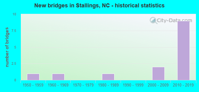
- New bridges - historical statistics
- 11950-1959
- 11960-1969
- 11980-1989
- 22000-2009
- 92010-2019
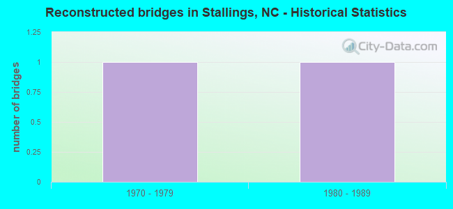
- Reconstructed bridges - Historical Statistics
- 11970-1979
- 11980-1989
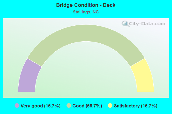
- Bridge Condition - Deck
- 16.7%Very good
- 66.7%Good
- 16.7%Satisfactory
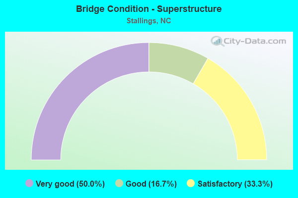
- Bridge Condition - Superstructure
- 50.0%Very good
- 16.7%Good
- 33.3%Satisfactory
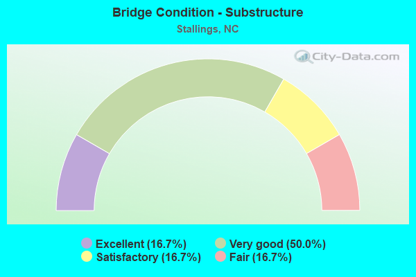
- Bridge Condition - Substructure
- 16.7%Excellent
- 50.0%Very good
- 16.7%Satisfactory
- 16.7%Fair
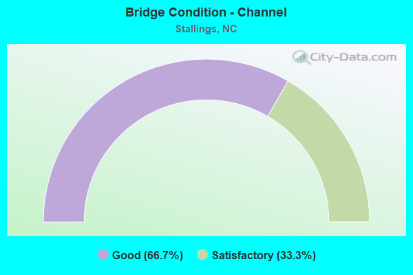
- Bridge Condition - Channel
- 66.7%Good
- 33.3%Satisfactory
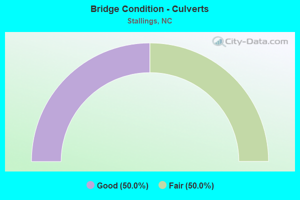
- Bridge Condition - Culverts
- 50.0%Good
- 50.0%Fair
Find on map >> Show street view
Structure Number: 1790261, Location: 0.5 MI.S.JCT.SR1365 (Lat: 35.106717, Lng: -80.673219), Route carried "on" structure: State highway 1524, Year Built: 2006, Status: Open, Structure Length: 1.28m (4.20ft), Average Daily Traffic: 2,700 (year 2017), Truck Traffic: 7%, Average Future Daily Traffic: 5,400 (year 2040), Design Load: HS 20+Mod, Features Intersected: N. FORK CROOKED CREEK
Minimum Vertical Clearance: 30+ m (98+ ft), Kilometerpoint: 0.000, Lanes on structure: 2, Owner: State Highway Agency, Approaching Roadway Width: 6.0m (19.7ft), Material/Design: Concrete, Design/Construction: Culvert, Number Of Spans In Main Unit: 1, Length of Maximum Span: 12.8m (42.0ft), Curb or Sidewalk Widths: Left: 0.1m (0.3ft), Right: 0.1m (0.3ft), Curb-To-Curb Width: 9.8m (32.2ft), Out-to-Out Width: 10.5m (34.4ft)
Condition: Channel: Satisfactory, Culverts: Good, Operating Rating: 41.7 metric tons, Method Used To Determine Operating Rating: Field evaluation and documented engineering judgment, Inventory Rating: 32.6 metric tons, Method Used To Determine Inventory Rating: Field evaluation and documented engineering judgment, Structural Evaluation: Better than present minimum criteria, Deck Geometry: Meets minimum limits, Waterway Adequacy: Better than present minimum criteria, Approach Roadway Alignment: Equal to present desirable criteria, Designated Inspection Frequency: Every 24 months, Inspection Date: Febuary 2022
Find on map >> Show street view
Structure Number: 1790262, Location: 0.3 MI.S.JCT.SR1501 (Lat: 35.115028, Lng: -80.650217), Route carried "on" structure: State highway 1524, Year Built: 2015, Status: Open, Structure Length: 2.43m (7.97ft), Average Daily Traffic: 4,900 (year 2013), Truck Traffic: 7%, Average Future Daily Traffic: 9,800 (year 2040), Design Load: HL 93, Features Intersected: NORTH FORK CROOKED CK.TR
Minimum Vertical Clearance: 30+ m (98+ ft), Kilometerpoint: 0.000, Lanes on structure: 2, Owner: State Highway Agency, Approaching Roadway Width: 11.2m (36.7ft), Material/Design: Prestressed concrete, Design/Construction: Slab, Number Of Spans In Main Unit: 2, Length of Maximum Span: 16.1m (52.8ft), Curb or Sidewalk Widths: Left: 0.0m, Right: 1.6m (5.2ft), Curb-To-Curb Width: 9.3m (30.5ft), Out-to-Out Width: 11.8m (38.7ft)
Condition: Deck: Very good, Superstructure: Very good, Substructure: Very good, Channel: Good, Operating Rating: 48.9 metric tons, Method Used To Determine Operating Rating: Load and Resistance Factor (LRFR), Inventory Rating: 38.1 metric tons, Method Used To Determine Inventory Rating: Load and Resistance Factor (LRFR), Structural Evaluation: Equal to present desirable criteria, Deck Geometry: Meets minimum limits, Waterway Adequacy: Better than present minimum criteria, Approach Roadway Alignment: Equal to present desirable criteria, Designated Inspection Frequency: Every 24 months, Inspection Date: April 2021, Deck Structure Type: Concrete Precast Panels, Wearing Surface/Protective System: Wearing Surface: Bituminous
Find on map >> Show street view
Structure Number: 1790263, Location: 0.2 MI. S. JCT. SR2324 (Lat: 35.130761, Lng: -80.631083), Route carried "on" structure: State highway 1524, Year Built: 1953, Year Reconstructed: 1986, Status: Open, Structure Length: 1.21m (3.97ft), Average Daily Traffic: 6,400 (year 2013), Truck Traffic: 7%, Average Future Daily Traffic: 12,800 (year 2040), Features Intersected: GOOSE CREEK
Minimum Vertical Clearance: 30+ m (98+ ft), Kilometerpoint: 0.000, Lanes on structure: 2, Owner: State Highway Agency, Approaching Roadway Width: 7.3m (24.0ft), Material/Design: Steel, Design/Construction: Stringer/Multi-beam, Number Of Spans In Main Unit: 1, Length of Maximum Span: 11.8m (38.7ft), Curb-To-Curb Width: 7.3m (24.0ft), Out-to-Out Width: 7.5m (24.6ft)
Condition: Deck: Satisfactory, Superstructure: Satisfactory, Substructure: Satisfactory, Channel: Good, Operating Rating: 82.5 metric tons, Method Used To Determine Operating Rating: Load Factor (LF), Inventory Rating: 48.9 metric tons, Method Used To Determine Inventory Rating: Load Factor (LF), Structural Evaluation: Equal to present minimum criteria, Deck Geometry: High priority of replacement, Waterway Adequacy: Better than present minimum criteria, Approach Roadway Alignment: Equal to present desirable criteria, Designated Inspection Frequency: Every 24 months, Inspection Date: November 2020, Deck Structure Type: Corrugated Steel, Wearing Surface/Protective System: Wearing Surface: Bituminous
Find on map >> Show street view
Structure Number: 1790377, Location: 0.3 MI. S. JCT. SR1178 (Lat: 34.836783, Lng: -80.791708), Route carried "on" structure: State highway 1103, Year Built: 2009, Status: Open, Structure Length: 2.89m (9.48ft), Average Daily Traffic: 180 (year 2016), Truck Traffic: 6%, Average Future Daily Traffic: 360 (year 2040), Design Load: HS 25 or greater, Features Intersected: WAXHAW CREEK
Minimum Vertical Clearance: 30+ m (98+ ft), Kilometerpoint: 0.000, Lanes on structure: 2, Owner: State Highway Agency, Approaching Roadway Width: 8.8m (28.9ft), Material/Design: Prestressed concrete, Design/Construction: Box Beam or Girders - Multiple, Number Of Spans In Main Unit: 1, Length of Maximum Span: 28.3m (92.8ft), Curb-To-Curb Width: 9.3m (30.5ft), Out-to-Out Width: 10.0m (32.8ft)
Condition: Deck: Good, Superstructure: Good, Substructure: Very good, Channel: Good, Operating Rating: 89.8 metric tons, Method Used To Determine Operating Rating: Load Factor (LF), Inventory Rating: 66.2 metric tons, Method Used To Determine Inventory Rating: Load Factor (LF), Structural Evaluation: Better than present minimum criteria, Deck Geometry: Equal to present minimum criteria, Waterway Adequacy: Better than present minimum criteria, Approach Roadway Alignment: Equal to present desirable criteria, Designated Inspection Frequency: Every 24 months, Inspection Date: June 2021, Deck Structure Type: Concrete Precast Panels, Wearing Surface/Protective System: Wearing Surface: Bituminous
Find on map >> Show street view
Structure Number: 1790379, Location: 0.4 MI. W. JCT. SR1522 (Lat: 35.100894, Lng: -80.657558), Route carried "on" structure: State highway 1523, Year Built: 1963, Year Reconstructed: 1981, Status: Posted for load, Structure Length: 1.12m (3.67ft), Average Daily Traffic: 870 (year 2000), Truck Traffic: 7%, Average Future Daily Traffic: 1,740 (year 2040), Features Intersected: NORTH FORK CROOKED CREEK
Minimum Vertical Clearance: 30+ m (98+ ft), Kilometerpoint: 0.000, Lanes on structure: 2, Owner: State Highway Agency, Approaching Roadway Width: 6.0m (19.7ft), Material/Design: Steel, Design/Construction: Stringer/Multi-beam, Number Of Spans In Main Unit: 1, Length of Maximum Span: 10.6m (34.8ft), Curb-To-Curb Width: 7.6m (24.9ft), Out-to-Out Width: 7.6m (24.9ft)
Condition: Deck: Good, Superstructure: Satisfactory, Substructure: Fair, Channel: Satisfactory, Operating Rating: 41.7 metric tons, Method Used To Determine Operating Rating: Load Factor (LF), Inventory Rating: 24.4 metric tons, Method Used To Determine Inventory Rating: Load Factor (LF), Structural Evaluation: Somewhat better than minimum adequacy, Deck Geometry: Meets minimum limits, Waterway Adequacy: Better than present minimum criteria, Approach Roadway Alignment: Equal to present desirable criteria, Bridge Posting: Required (Relationship of Operating Rating to Maximum Legal Load: 0.1 - 9.9% below), Designated Inspection Frequency: Every 24 months, Inspection Date: November 2020, Deck Structure Type: Corrugated Steel, Wearing Surface/Protective System: Wearing Surface: Bituminous
Find on map >> Show street view
Structure Number: 1790541, Location: 2.5 MI. W. JCT. SR1367 (Lat: 35.097667, Lng: -80.675333), Route carried "on" structure: Bypass US 74, Year Built: 2018, Status: Open, Structure Length: 6.85m (22.47ft), Average Daily Traffic: 62,000 (year 2013), Truck Traffic: 12%, Average Future Daily Traffic: 124,000 (year 2040), Design Load: HL 93, Features Intersected: SR1365
Minimum Vertical Clearance: 30+ m (98+ ft), Kilometerpoint: 0.000, Lanes on structure: 4, Lanes under structure: 4, Base Highway Network: Yes (Inventory Route: 2, Subroute: 74), Owner: State Highway Agency, Approaching Roadway Width: 35.3m (115.8ft), Skew: 10 degrees, Material/Design: Prestressed concrete, Design/Construction: Stringer/Multi-beam, Number Of Spans In Main Unit: 2, Length of Maximum Span: 39.3m (128.9ft), Curb-To-Curb Width: 17.6m (57.7ft), Out-to-Out Width: 37.1m (121.7ft)
Condition: Deck: Good, Superstructure: Very good, Substructure: Excellent, Operating Rating: 67.1 metric tons, Method Used To Determine Operating Rating: Load and Resistance Factor (LRFR), Inventory Rating: 51.7 metric tons, Method Used To Determine Inventory Rating: Load and Resistance Factor (LRFR), Structural Evaluation: Equal to present desirable criteria, Deck Geometry: Somewhat better than minimum adequacy, Underclear: Meets minimum limits, Approach Roadway Alignment: Equal to present desirable criteria, Designated Inspection Frequency: Every 24 months, Inspection Date: June 2020, Deck Structure Type: Concrete Cast-file-Place, Wearing Surface/Protective System: Wearing Surface: Monolithic Concrete
Find on map >> Show street view
Structure Number: 1790542, Location: 0.65 MI. W. JCT. SR1008 (Lat: 35.090806, Lng: -80.668194), Route carried "on" structure: Business US 74, Year Built: 2018, Status: Open, Structure Length: 11.33m (37.17ft), Average Daily Traffic: 28,500 (year 2017), Truck Traffic: 12%, Average Future Daily Traffic: 57,000 (year 2040), Design Load: HL 93, Features Intersected: US74 BYP, MONROE EXPRESS
Minimum Vertical Clearance: 30+ m (98+ ft), Kilometerpoint: 77.572, Lanes on structure: 2, Lanes under structure: 8, Owner: State Highway Agency, Approaching Roadway Width: 12.4m (40.7ft), Skew: 6 degrees, Material/Design: Steel continuous, Design/Construction: Stringer/Multi-beam, Number Of Spans In Main Unit: 2, Length of Maximum Span: 59.1m (193.9ft), Curb-To-Curb Width: 11.5m (37.7ft), Out-to-Out Width: 12.6m (41.3ft)
Condition: Deck: Good, Superstructure: Very good, Substructure: Very good, Operating Rating: 89.8 metric tons, Method Used To Determine Operating Rating: Load and Resistance Factor (LRFR), Inventory Rating: 89.8 metric tons, Method Used To Determine Inventory Rating: Load and Resistance Factor (LRFR), Structural Evaluation: Equal to present desirable criteria, Deck Geometry: Equal to present minimum criteria, Underclear: Equal to present minimum criteria, Approach Roadway Alignment: Equal to present desirable criteria, Designated Inspection Frequency: Every 24 months, Inspection Date: June 2020, Deck Structure Type: Concrete Cast-file-Place, Wearing Surface/Protective System: Wearing Surface: Monolithic Concrete
Find on map >> Show street view
Structure Number: 1790561, Location: 400'EAST OF FAIRFIELD DR. (Lat: 35.129694, Lng: -80.623917), Route carried "on" structure: City street , Year Built: 1980, Status: Open, Structure Length: 0.64m (2.10ft), Average Daily Traffic: 500 (year 2012), Truck Traffic: 7%, Average Future Daily Traffic: 1,000 (year 2040), Design Load: HS 20+Mod, Features Intersected: UT TO GOOSE CREEK, Facility Carried by Structure: LAKE DRIVE
Minimum Vertical Clearance: 30+ m (98+ ft), Kilometerpoint: 0.000, Lanes on structure: 2, Owner: City or Municipal Highway Agency, Approaching Roadway Width: 7.6m (24.9ft), Skew: 1 degrees, Material/Design: Steel, Design/Construction: Culvert, Number Of Spans In Main Unit: 3, Length of Maximum Span: 1.5m (4.9ft)
Condition: Channel: Good, Culverts: Fair, Operating Rating: 89.8 metric tons, Method Used To Determine Operating Rating: Load and Resistance Factor (LRFR), Inventory Rating: 89.8 metric tons, Method Used To Determine Inventory Rating: Load and Resistance Factor (LRFR), Structural Evaluation: Somewhat better than minimum adequacy, Waterway Adequacy: Better than present minimum criteria, Approach Roadway Alignment: Equal to present desirable criteria, Designated Inspection Frequency: Every 24 months, Inspection Date: April 2020
Find on map >> Show street view
Structure Number: 179054, Location: 0.3 MI. W. JCT. STALLINGS (Lat: 35.101417, Lng: -80.679139), Route carried "under" structure: State highway , Year Built: 2018, Structure Length: 0. m, Average Daily Traffic: 17,000 (year 2017), Truck Traffic: 7%, Features Intersected: US74 BYP, Facility Carried by Structure: SR3909
Minimum Vertical Clearance: 5.01m (16.44ft), Kilometerpoint: 0.000, Lanes on structure: 2, Lanes under structure: 4, Material/Design: Prestressed concrete, Design/Construction: Stringer/Multi-beam, Length of Maximum Span: 39.0m (128.0ft)
Find on map >> Show street view
Structure Number: 1790541, Location: 2.5 MI. W. JCT. SR1367 (Lat: 35.097667, Lng: -80.675333), Route carried "under" structure: State highway 1367, Year Built: 2018, Structure Length: 0. m, Average Daily Traffic: 11,000 (year 2016), Truck Traffic: 6%, Features Intersected: US74 BYP
Minimum Vertical Clearance: 5.59m (18.34ft), Kilometerpoint: 0.000, Lanes on structure: 4, Lanes under structure: 4, Material/Design: Prestressed concrete, Design/Construction: Stringer/Multi-beam, Length of Maximum Span: 39.3m (128.9ft)
Find on map >> Show street view
Structure Number: 1790542, Location: 0.65 MI. W. JCT. SR1008 (Lat: 35.090806, Lng: -80.668194), Route carried "under" structure: US 74, Year Built: 2018, Structure Length: 0. m, Average Daily Traffic: 14,250 (year 2017), Truck Traffic: 12%, Features Intersected: US74 BUS WBL
Minimum Vertical Clearance: 6.68m (21.92ft), Kilometerpoint: 0.000, Lanes on structure: 2, Lanes under structure: 2, Material/Design: Steel continuous, Design/Construction: Stringer/Multi-beam, Length of Maximum Span: 59.1m (193.9ft)
Find on map >> Show street view
Structure Number: 1790542, Location: 0.65 MI. W. JCT. SR1008 (Lat: 35.090806, Lng: -80.668194), Route carried "under" structure: US 74, Year Built: 2018, Structure Length: 0. m, Average Daily Traffic: 14,250 (year 2017), Truck Traffic: 12%, Features Intersected: US74 BUS WBL
Minimum Vertical Clearance: 6.17m (20.24ft), Kilometerpoint: 0.000, Lanes on structure: 2, Lanes under structure: 2, Material/Design: Steel continuous, Design/Construction: Stringer/Multi-beam, Length of Maximum Span: 59.1m (193.9ft)
Find on map >> Show street view
Structure Number: 1790542, Location: 0.65 MI. W. JCT. SR1008 (Lat: 35.090806, Lng: -80.668194), Route carried "under" structure: US 74, Year Built: 2018, Structure Length: 0. m, Average Daily Traffic: 14,250 (year 2017), Truck Traffic: 12%, Features Intersected: US74 BUS WBL
Minimum Vertical Clearance: 6.13m (20.11ft), Kilometerpoint: 0.000, Lanes on structure: 2, Lanes under structure: 2, Material/Design: Steel continuous, Design/Construction: Stringer/Multi-beam, Length of Maximum Span: 59.1m (193.9ft)
Find on map >> Show street view
Structure Number: 1790542, Location: 0.65 MI. W. JCT. SR1008 (Lat: 35.090806, Lng: -80.668194), Route carried "under" structure: US 74, Year Built: 2018, Structure Length: 0. m, Average Daily Traffic: 11,000 (year 2016), Truck Traffic: 6%, Features Intersected: US74 BUS WBL
Minimum Vertical Clearance: 6.68m (21.92ft), Kilometerpoint: 0.000, Lanes on structure: 2, Lanes under structure: 2, Material/Design: Steel continuous, Design/Construction: Stringer/Multi-beam, Length of Maximum Span: 59.1m (193.9ft)