Bridge Statistics for Stanhope, New Jersey (NJ)
Condition, Traffic, Stress, Structural Evaluation, Project Costs
- National Bridge Inventory (NBI) Statistics
- 19Number of bridges
- 121ft / 37.3mTotal length
- $13,133,000Total costs
- 293,658Total average daily traffic
- 17,101Total average daily truck traffic
- National Bridge Inventory (NBI) Registered Bridges for Stanhope
- No street view available for this location
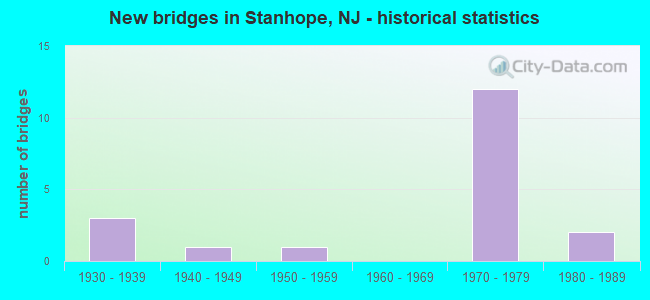
- New bridges - historical statistics
- 31930-1939
- 11940-1949
- 11950-1959
- 121970-1979
- 21980-1989

- Reconstructed bridges - Historical Statistics
- 21970-1979
- 11980-1989


- Bridge Condition - Deck
- 36.4%Good
- 27.3%Satisfactory
- 36.4%Fair

- Bridge Condition - Superstructure
- 36.4%Good
- 27.3%Satisfactory
- 36.4%Fair

- Bridge Condition - Substructure
- 27.3%Good
- 45.5%Satisfactory
- 18.2%Fair
- 9.1%Poor

- Bridge Condition - Channel
- 40.0%Very good
- 60.0%Good
Find on map >> Show street view
Structure Number: 220154, Location: 0.99 MI EAST OF GSP (Lat: 40.891481, Lng: -74.102500), Route carried "on" structure: US 46, Year Built: 1936, Status: Open, Structure Length: 4.60m (15.09ft), Average Daily Traffic: 55,415 (year 2021), Truck Traffic: 4%, Average Future Daily Traffic: 66,500 (year 2041), Features Intersected: ERIE-LACKAWANNA RAILROAD
Minimum Vertical Clearance: 30+ m (98+ ft), Kilometerpoint: 105.251, Lanes on structure: 4, Base Highway Network: Yes, Owner: State Highway Agency, Approaching Roadway Width: 21.3m (69.9ft), Skew: 32 degrees, Material/Design: Steel continuous, Design/Construction: Stringer/Multi-beam, Number Of Spans In Main Unit: 3, Length of Maximum Span: 22.3m (73.2ft), Curb or Sidewalk Widths: Left: 1.5m (4.9ft), Right: 1.5m (4.9ft), Curb-To-Curb Width: 21.3m (69.9ft), Out-to-Out Width: 25.8m (84.6ft)
Condition: Deck: Fair, Superstructure: Fair, Substructure: Poor, Operating Rating: 72.6 metric tons, Method Used To Determine Operating Rating: Load Factor (LF), Inventory Rating: 43.5 metric tons, Method Used To Determine Inventory Rating: Load Factor (LF), Structural Evaluation: Meets minimum limits, Deck Geometry: Superior to present desirable criteria, Underclear: Meets minimum limits, Approach Roadway Alignment: Equal to present desirable criteria, Length Of Structure Improvement: 5.49m (18.01ft), Designated Inspection Frequency: Every 24 months, Inspection Date: July 2021, Bridge Improvement Cost: $5,171,000, Roadway Improvement Cost: $517,000, Total Project Cost: $8,029,000 ( Estimate for 2021), Deck Structure Type: Concrete Cast-file-Place, Wearing Surface/Protective System: Wearing Surface: Bituminous
Find on map >> Show street view
Structure Number: 220155, Location: 1.6 MILES EAST OF GSP (Lat: 40.886639, Lng: -74.091619), Route carried "on" structure: County highway 42, Year Built: 1936, Status: Open, Structure Length: 3.14m (10.30ft), Average Daily Traffic: 12,990 (year 2021), Truck Traffic: 4%, Average Future Daily Traffic: 15,600 (year 2041), Features Intersected: US 46, Facility Carried by Structure: OUTWATER LANE
Minimum Vertical Clearance: 30+ m (98+ ft), Kilometerpoint: 2.543, Lanes on structure: 2, Lanes under structure: 4, Owner: State Highway Agency, Approaching Roadway Width: 9.1m (29.9ft), Skew: 3 degrees, Material/Design: Steel, Design/Construction: Stringer/Multi-beam, Number Of Spans In Main Unit: 2, Length of Maximum Span: 14.6m (47.9ft), Curb or Sidewalk Widths: Left: 2.0m (6.6ft), Right: 2.0m (6.6ft), Curb-To-Curb Width: 9.1m (29.9ft), Out-to-Out Width: 13.7m (44.9ft)
Condition: Deck: Fair, Superstructure: Fair, Substructure: Fair, Operating Rating: 55.3 metric tons, Method Used To Determine Operating Rating: Load Factor (LF), Inventory Rating: 32.7 metric tons, Method Used To Determine Inventory Rating: Load Factor (LF), Structural Evaluation: Somewhat better than minimum adequacy, Deck Geometry: High priority of corrective action, Underclear: Meets minimum limits, Approach Roadway Alignment: Equal to present minimum criteria, Length Of Structure Improvement: 4.08m (13.39ft), Designated Inspection Frequency: Every 24 months, Inspection Date: September 2021, Bridge Improvement Cost: $3,618,000, Roadway Improvement Cost: $50,000, Total Project Cost: $5,086,000 ( Estimate for 2021), Deck Structure Type: Concrete Cast-file-Place, Wearing Surface/Protective System: Wearing Surface: Bituminous
Find on map >> Show street view
Structure Number: 70316, Location: 0.9 MI SO OF I-95 (Lat: 40.726781, Lng: -74.138761), Route carried "on" structure: US 1, Year Built: 1948, Year Reconstructed: 1991, Status: Open, Structure Length: 8.17m (26.80ft), Average Daily Traffic: 44,609 (year 2020), Truck Traffic: 5%, Average Future Daily Traffic: 53,531 (year 2040), Design Load: HS 20+Mod, Features Intersected: CONRAIL & RICHARDS LANE
Minimum Vertical Clearance: 30+ m (98+ ft), Kilometerpoint: 81.385, Lanes on structure: 5, Lanes under structure: 4, Base Highway Network: Yes, Owner: State Highway Agency, Approaching Roadway Width: 22.9m (75.1ft), Skew: 33 degrees, Material/Design: Steel continuous, Design/Construction: Stringer/Multi-beam, Number Of Spans In Main Unit: 3, Length of Maximum Span: 32.0m (105.0ft), Curb-To-Curb Width: 22.3m (73.2ft), Out-to-Out Width: 24.1m (79.1ft)
Condition: Deck: Good, Superstructure: Good, Substructure: Satisfactory, Inventory Rating: 61.7 metric tons, Method Used To Determine Inventory Rating: Load Factor (LF), Structural Evaluation: Equal to present minimum criteria, Deck Geometry: Meets minimum limits, Underclear: Meets minimum limits, Approach Roadway Alignment: Equal to present desirable criteria, Designated Inspection Frequency: Every 24 months, Inspection Date: July 2020, Deck Structure Type: Concrete Cast-file-Place, Wearing Surface/Protective System: Wearing Surface: Latex Concrete, Deck Protection: Epoxy Coated Reinforcing
Find on map >> Show street view
Structure Number: 1427153, Location: AT I-80 INTERCHANGE 25 (Lat: 40.905750, Lng: -74.724919), Route carried "on" structure: Interstate 80, Year Built: 1970, Year Reconstructed: 1984, Status: Open, Structure Length: 3.87m (12.70ft), Average Daily Traffic: 30,159 (year 2021), Truck Traffic: 9%, Average Future Daily Traffic: 36,191 (year 2041), Design Load: HS 20, Features Intersected: US 206 SB & I-80 EB RAMP
Minimum Vertical Clearance: 30+ m (98+ ft), Kilometerpoint: 40.636, Lanes on structure: 3, Lanes under structure: 3, Base Highway Network: Yes, Owner: State Highway Agency, Approaching Roadway Width: 16.5m (54.1ft), Skew: 2 degrees, Material/Design: Steel, Design/Construction: Stringer/Multi-beam, Number Of Spans In Main Unit: 1, Length of Maximum Span: 36.6m (120.1ft), Curb or Sidewalk Widths: Left: 0.2m (0.7ft), Right: 0.2m (0.7ft), Curb-To-Curb Width: 16.5m (54.1ft), Out-to-Out Width: 17.6m (57.7ft)
Condition: Deck: Satisfactory, Superstructure: Satisfactory, Substructure: Satisfactory, Operating Rating: 88.9 metric tons, Method Used To Determine Operating Rating: Load Factor (LF), Inventory Rating: 52.6 metric tons, Method Used To Determine Inventory Rating: Load Factor (LF), Structural Evaluation: Equal to present minimum criteria, Deck Geometry: Equal to present minimum criteria, Underclear: High priority of corrective action, Approach Roadway Alignment: Better than present minimum criteria, Designated Inspection Frequency: Every 24 months, Inspection Date: March 2021, Deck Structure Type: Concrete Cast-file-Place, Wearing Surface/Protective System: Wearing Surface: Bituminous
Find on map >> Show street view
Structure Number: 1427154, Location: I-80 INTERCHANGE (Lat: 40.905969, Lng: -74.724450), Route carried "on" structure: Interstate 80, Year Built: 1970, Year Reconstructed: 1984, Status: Open, Structure Length: 3.69m (12.11ft), Average Daily Traffic: 30,159 (year 2021), Truck Traffic: 9%, Average Future Daily Traffic: 36,191 (year 2041), Design Load: HS 20, Features Intersected: US 206 SB & I-80 EB RAMP
Minimum Vertical Clearance: 30+ m (98+ ft), Kilometerpoint: 40.636, Lanes on structure: 3, Lanes under structure: 3, Base Highway Network: Yes, Owner: State Highway Agency, Approaching Roadway Width: 16.5m (54.1ft), Skew: 2 degrees, Material/Design: Steel, Design/Construction: Stringer/Multi-beam, Number Of Spans In Main Unit: 1, Length of Maximum Span: 35.1m (115.2ft), Curb or Sidewalk Widths: Left: 0.2m (0.7ft), Right: 0.2m (0.7ft), Curb-To-Curb Width: 16.5m (54.1ft), Out-to-Out Width: 17.6m (57.7ft)
Condition: Deck: Satisfactory, Superstructure: Satisfactory, Substructure: Satisfactory, Operating Rating: 84.4 metric tons, Method Used To Determine Operating Rating: Load Factor (LF), Inventory Rating: 49.9 metric tons, Method Used To Determine Inventory Rating: Load Factor (LF), Structural Evaluation: Equal to present minimum criteria, Deck Geometry: Equal to present minimum criteria, Underclear: High priority of corrective action, Approach Roadway Alignment: Equal to present desirable criteria, Length Of Structure Improvement: 3.69m (12.11ft), Designated Inspection Frequency: Every 24 months, Inspection Date: March 2021, Roadway Improvement Cost: $14,000, Total Project Cost: $17,000 ( Estimate for 2019), Deck Structure Type: Concrete Cast-file-Place, Wearing Surface/Protective System: Wearing Surface: Bituminous
Find on map >> Show street view
Structure Number: 142815, Location: 0.1 MI N. OF RT 206 (Lat: 40.919061, Lng: -74.736431), Route carried "on" structure: Other road , Year Built: 1987, Status: Open, Structure Length: 2.32m (7.61ft), Average Daily Traffic: 1,321 (year 2021), Truck Traffic: 1%, Average Future Daily Traffic: 1,585 (year 2041), Features Intersected: MUSCONETCONG RIVER, Facility Carried by Structure: CONTINENTAL DRIVE
Minimum Vertical Clearance: 30+ m (98+ ft), Kilometerpoint: 0.000, Lanes on structure: 2, Owner: State Highway Agency, Approaching Roadway Width: 9.4m (30.8ft), Material/Design: Prestressed concrete, Design/Construction: Box Beam or Girders - Multiple, Number Of Spans In Main Unit: 1, Length of Maximum Span: 22.6m (74.1ft), Curb-To-Curb Width: 9.4m (30.8ft), Out-to-Out Width: 10.7m (35.1ft)
Condition: Deck: Good, Superstructure: Good, Substructure: Good, Channel: Very good, Operating Rating: 54.4 metric tons, Method Used To Determine Operating Rating: Field evaluation and documented engineering judgment, Inventory Rating: 32.7 metric tons, Method Used To Determine Inventory Rating: Field evaluation and documented engineering judgment, Structural Evaluation: Better than present minimum criteria, Deck Geometry: Somewhat better than minimum adequacy, Waterway Adequacy: Better than present minimum criteria, Approach Roadway Alignment: Equal to present desirable criteria, Designated Inspection Frequency: Every 24 months, Inspection Date: March 2021, Deck Structure Type: Concrete Cast-file-Place, Wearing Surface/Protective System: Wearing Surface: Monolithic Concrete, Deck Protection: Epoxy Coated Reinforcing
Find on map >> Show street view
Structure Number: 1428153, Location: 0.4 MI NORTH OF I-80 (Lat: 40.909100, Lng: -74.721169), Route carried "on" structure: City street , Year Built: 1970, Status: Open, Structure Length: 3.11m (10.20ft), Average Daily Traffic: 4,121 (year 2021), Truck Traffic: 1%, Average Future Daily Traffic: 4,945 (year 2041), Design Load: HS 20, Features Intersected: US 206, Facility Carried by Structure: CONTINENTAL DRIVE
Minimum Vertical Clearance: 30+ m (98+ ft), Kilometerpoint: 8.916, Lanes on structure: 2, Lanes under structure: 6, Owner: State Highway Agency, Approaching Roadway Width: 9.1m (29.9ft), Material/Design: Steel, Design/Construction: Stringer/Multi-beam, Number Of Spans In Main Unit: 1, Length of Maximum Span: 29.6m (97.1ft), Curb or Sidewalk Widths: Left: 0.5m (1.6ft), Right: 1.8m (5.9ft), Curb-To-Curb Width: 9.1m (29.9ft), Out-to-Out Width: 12.1m (39.7ft)
Condition: Deck: Good, Superstructure: Fair, Substructure: Satisfactory, Operating Rating: 87.1 metric tons, Method Used To Determine Operating Rating: Load Factor (LF), Inventory Rating: 51.7 metric tons, Method Used To Determine Inventory Rating: Load Factor (LF), Structural Evaluation: Somewhat better than minimum adequacy, Deck Geometry: Meets minimum limits, Underclear: Equal to present minimum criteria, Approach Roadway Alignment: Equal to present desirable criteria, Designated Inspection Frequency: Every 24 months, Inspection Date: April 2021, Deck Structure Type: Concrete Cast-file-Place, Wearing Surface/Protective System: Wearing Surface: Monolithic Concrete
Find on map >> Show street view
Structure Number: 1428155, Location: 0.51 MI N of I-80 EXIT 25 (Lat: 40.911481, Lng: -74.717869), Route carried "on" structure: US 206, Year Built: 1970, Status: Open, Structure Length: 1.04m (3.41ft), Average Daily Traffic: 19,254 (year 2021), Truck Traffic: 4%, Average Future Daily Traffic: 23,429 (year 2041), Design Load: HS 20, Features Intersected: MUSCONETCONG RIVER
Minimum Vertical Clearance: 30+ m (98+ ft), Kilometerpoint: 157.281, Lanes on structure: 5, Base Highway Network: Yes, Owner: State Highway Agency, Approaching Roadway Width: 23.8m (78.1ft), Skew: 32 degrees, Material/Design: Prestressed concrete, Design/Construction: Culvert, Number Of Spans In Main Unit: 1, Length of Maximum Span: 8.8m (28.9ft)
Condition: Channel: Good, Culverts: Fair, Inventory Rating: 54.4 metric tons, Method Used To Determine Inventory Rating: Load Factor (LF), Structural Evaluation: Somewhat better than minimum adequacy, Waterway Adequacy: Superior to present desirable criteria, Approach Roadway Alignment: Equal to present minimum criteria, Designated Inspection Frequency: Every 24 months, Inspection Date: April 2021
Find on map >> Show street view
Structure Number: 1900C05, Location: 0.78 mi west of US 206 (Lat: 40.921031, Lng: -74.731939), Route carried "on" structure: County highway 604, Year Built: 1986, Status: Open, Structure Length: 2.41m (7.91ft), Average Daily Traffic: 2,914 (year 2021), Truck Traffic: 3%, Average Future Daily Traffic: 3,556 (year 2041), Design Load: HS 20, Features Intersected: LUBBERS RUN
Minimum Vertical Clearance: 30+ m (98+ ft), Kilometerpoint: 3.412, Lanes on structure: 2, Owner: County Highway Agency, Approaching Roadway Width: 11.0m (36.1ft), Skew: 2 degrees, Material/Design: Prestressed concrete, Design/Construction: Box Beam or Girders - Multiple, Number Of Spans In Main Unit: 1, Length of Maximum Span: 22.6m (74.1ft), Curb or Sidewalk Widths: Left: 1.2m (3.9ft), Right: 0.5m (1.6ft), Curb-To-Curb Width: 9.8m (32.2ft), Out-to-Out Width: 12.3m (40.4ft)
Condition: Deck: Good, Superstructure: Good, Substructure: Good, Channel: Very good, Operating Rating: 85.3 metric tons, Method Used To Determine Operating Rating: Load Factor (LF), Inventory Rating: 50.8 metric tons, Method Used To Determine Inventory Rating: Load Factor (LF), Structural Evaluation: Better than present minimum criteria, Deck Geometry: Meets minimum limits, Waterway Adequacy: Superior to present desirable criteria, Approach Roadway Alignment: Equal to present desirable criteria, Length Of Structure Improvement: 2.41m (7.91ft), Designated Inspection Frequency: Every 24 months, Inspection Date: March 2021, Total Project Cost: $1,000 ( Estimate for 2021), Deck Structure Type: Concrete Cast-file-Place, Wearing Surface/Protective System: Wearing Surface: Bituminous, Deck Protection: Epoxy Coated Reinforcing
Find on map >> Show street view
Structure Number: 1900R01, Location: 0.4 MI SW OF NJ 183 (Lat: 40.899511, Lng: -74.710689), Route carried "on" structure: City street , Year Built: 1954, Status: Open, Structure Length: 1.04m (3.41ft), Average Daily Traffic: 1,125 (year 2021), Truck Traffic: 1%, Average Future Daily Traffic: 1,373 (year 2041), Features Intersected: MUSCONETCONG RIVER, Facility Carried by Structure: FURNACE STREET
Minimum Vertical Clearance: 30+ m (98+ ft), Kilometerpoint: 0.000, Lanes on structure: 2, Owner: County Highway Agency, Approaching Roadway Width: 6.7m (22.0ft), Material/Design: Steel, Design/Construction: Stringer/Multi-beam, Number Of Spans In Main Unit: 1, Length of Maximum Span: 9.4m (30.8ft), Curb or Sidewalk Widths: Left: 1.5m (4.9ft), Right: 0.0m, Curb-To-Curb Width: 5.9m (19.4ft), Out-to-Out Width: 9.1m (29.9ft)
Condition: Deck: Fair, Superstructure: Satisfactory, Substructure: Satisfactory, Channel: Good, Operating Rating: 59.9 metric tons, Method Used To Determine Operating Rating: Load Factor (LF), Inventory Rating: 35.4 metric tons, Method Used To Determine Inventory Rating: Load Factor (LF), Structural Evaluation: Equal to present minimum criteria, Deck Geometry: High priority of replacement, Waterway Adequacy: Equal to present desirable criteria, Approach Roadway Alignment: Equal to present desirable criteria, Length Of Structure Improvement: 1.04m (3.41ft), Designated Inspection Frequency: Every 24 months, Inspection Date: March 2021, Deck Structure Type: Concrete Cast-file-Place, Wearing Surface/Protective System: Wearing Surface: Bituminous, Membrane: Preformed Fabric
Find on map >> Show street view
Structure Number: 191116, Location: 2.97 MI SOUTH OF NJ 94 (Lat: 41.019511, Lng: -74.769100), Route carried "on" structure: US 206, Year Built: 1931, Status: Open, Structure Length: 0.70m (2.30ft), Average Daily Traffic: 13,688 (year 2019), Truck Traffic: 4%, Average Future Daily Traffic: 16,426 (year 2039), Features Intersected: BR OF PEQUEST RIVER
Minimum Vertical Clearance: 30+ m (98+ ft), Kilometerpoint: 171.041, Lanes on structure: 2, Base Highway Network: Yes, Owner: State Highway Agency, Approaching Roadway Width: 12.2m (40.0ft), Skew: 1 degrees, Material/Design: Concrete, Design/Construction: Slab, Number Of Spans In Main Unit: 1, Length of Maximum Span: 6.7m (22.0ft), Curb-To-Curb Width: 12.2m (40.0ft), Out-to-Out Width: 13.5m (44.3ft)
Condition: Deck: Fair, Superstructure: Fair, Substructure: Good, Channel: Good, Operating Rating: 78.0 metric tons, Method Used To Determine Operating Rating: Load Factor (LF), Inventory Rating: 46.3 metric tons, Method Used To Determine Inventory Rating: Load Factor (LF), Structural Evaluation: Somewhat better than minimum adequacy, Deck Geometry: Somewhat better than minimum adequacy, Waterway Adequacy: Equal to present minimum criteria, Approach Roadway Alignment: Better than present minimum criteria, Designated Inspection Frequency: Every 24 months, Inspection Date: July 2021, Deck Structure Type: Concrete Cast-file-Place, Wearing Surface/Protective System: Wearing Surface: Bituminous
Find on map >> Show street view
Structure Number: 1911164, Location: 0.7 MI NORTH OF I-80 Jct (Lat: 40.913619, Lng: -74.716219), Route carried "on" structure: US 206, Year Built: 1970, Status: Open, Structure Length: 3.17m (10.40ft), Average Daily Traffic: 9,580 (year 2020), Truck Traffic: 4%, Average Future Daily Traffic: 11,500 (year 2040), Design Load: HS 20+Mod, Features Intersected: NJ 183 SB
Minimum Vertical Clearance: 30+ m (98+ ft), Kilometerpoint: 157.555, Lanes on structure: 2, Lanes under structure: 1, Base Highway Network: Yes, Owner: State Highway Agency, Approaching Roadway Width: 12.2m (40.0ft), Skew: 4 degrees, Material/Design: Steel, Design/Construction: Stringer/Multi-beam, Number Of Spans In Main Unit: 1, Length of Maximum Span: 29.6m (97.1ft), Curb-To-Curb Width: 12.4m (40.7ft), Out-to-Out Width: 13.5m (44.3ft)
Condition: Deck: Satisfactory, Superstructure: Good, Substructure: Fair, Operating Rating: 82.6 metric tons, Method Used To Determine Operating Rating: Load Factor (LF), Inventory Rating: 49.0 metric tons, Method Used To Determine Inventory Rating: Load Factor (LF), Structural Evaluation: Somewhat better than minimum adequacy, Deck Geometry: Better than present minimum criteria, Underclear: Equal to present minimum criteria, Approach Roadway Alignment: Better than present minimum criteria, Designated Inspection Frequency: Every 24 months, Inspection Date: August 2020, Deck Structure Type: Concrete Cast-file-Place, Wearing Surface/Protective System: Wearing Surface: Latex Concrete
Find on map >> Show street view
Structure Number: 142715, Location: 0.2 MI WEST OF RTE 206 (Lat: 40.907631, Lng: -74.727811), Route carried "under" structure: Interstate 80, Year Built: 1970, Structure Length: 0. m, Average Daily Traffic: 20,105 (year 2021), Truck Traffic: 14%, Features Intersected: I-80, Facility Carried by Structure: International Dr
Minimum Vertical Clearance: 4.95m (16.24ft), Kilometerpoint: 40.298, Lanes on structure: 2, Lanes under structure: 7, Material/Design: Steel, Design/Construction: Stringer/Multi-beam, Length of Maximum Span: 32.3m (106.0ft)
Find on map >> Show street view
Structure Number: 1427153, Location: AT I-80 INTERCHANGE 25 (Lat: 40.905750, Lng: -74.724919), Route carried "under" structure: US 206, Year Built: 1970, Structure Length: 0. m, Average Daily Traffic: 9,762 (year 2021), Truck Traffic: 4%, Features Intersected: US 206 SB & I-80 EB RAMP, Facility Carried by Structure: I-80 EB
Minimum Vertical Clearance: 4.72m (15.49ft), Kilometerpoint: 156.605, Lanes on structure: 3, Lanes under structure: 2, Material/Design: Steel, Design/Construction: Stringer/Multi-beam, Length of Maximum Span: 36.6m (120.1ft)
Find on map >> Show street view
Structure Number: 1427153, Location: AT I-80 INTERCHANGE 25 (Lat: 40.905750, Lng: -74.724919), Route carried "under" structure: Ramp Interstate 80, Year Built: 1970, Structure Length: 0. m, Average Daily Traffic: 2,570 (year 2021), Truck Traffic: 9%, Features Intersected: US 206 SB & I-80 EB RAMP
Minimum Vertical Clearance: 5.64m (18.50ft), Kilometerpoint: 40.636, Lanes on structure: 3, Lanes under structure: 1, Material/Design: Steel, Design/Construction: Stringer/Multi-beam, Length of Maximum Span: 36.6m (120.1ft)
Find on map >> Show street view
Structure Number: 1427154, Location: I-80 INTERCHANGE (Lat: 40.905969, Lng: -74.724450), Route carried "under" structure: US 206, Year Built: 1970, Structure Length: 0. m, Average Daily Traffic: 9,762 (year 2021), Truck Traffic: 9%, Features Intersected: US 206 SB & I-80 EB RAMP, Facility Carried by Structure: I-80 WB
Minimum Vertical Clearance: 4.72m (15.49ft), Kilometerpoint: 156.605, Lanes on structure: 3, Lanes under structure: 2, Material/Design: Steel, Design/Construction: Stringer/Multi-beam, Length of Maximum Span: 35.1m (115.2ft)
Find on map >> Show street view
Structure Number: 1427154, Location: I-80 INTERCHANGE (Lat: 40.905969, Lng: -74.724450), Route carried "under" structure: Ramp Interstate 80, Year Built: 1970, Structure Length: 0. m, Average Daily Traffic: 2,520 (year 2019), Truck Traffic: 9%, Features Intersected: US 206 SB & I-80 EB RAMP
Minimum Vertical Clearance: 5.56m (18.24ft), Kilometerpoint: 40.636, Lanes on structure: 3, Lanes under structure: 1, Material/Design: Steel, Design/Construction: Stringer/Multi-beam, Length of Maximum Span: 35.1m (115.2ft)
Find on map >> Show street view
Structure Number: 1428153, Location: 0.4 MI NORTH OF I-80 (Lat: 40.909100, Lng: -74.721169), Route carried "under" structure: US 206, Year Built: 1970, Structure Length: 0. m, Average Daily Traffic: 19,524 (year 2021), Truck Traffic: 1%, Features Intersected: US 206, Facility Carried by Structure: CONTINENTAL DRIVE
Minimum Vertical Clearance: 4.90m (16.08ft), Kilometerpoint: 156.895, Lanes on structure: 2, Lanes under structure: 6, Material/Design: Steel, Design/Construction: Stringer/Multi-beam, Length of Maximum Span: 29.6m (97.1ft)
Find on map >> Show street view
Structure Number: 1911164, Location: 0.7 MI NORTH OF I-80 Jct (Lat: 40.913619, Lng: -74.716219), Route carried "under" structure: State highway 183, Year Built: 1970, Structure Length: 0. m, Average Daily Traffic: 4,080 (year 2020), Truck Traffic: 3%, Features Intersected: NJ 183 SB, Facility Carried by Structure: US 206 NB
Minimum Vertical Clearance: 4.93m (16.17ft), Kilometerpoint: 3.412, Lanes on structure: 2, Lanes under structure: 1, Material/Design: Steel, Design/Construction: Stringer/Multi-beam, Length of Maximum Span: 29.6m (97.1ft)