Bridge Statistics for Star, North Carolina (NC)
Condition, Traffic, Stress, Structural Evaluation, Project Costs
- National Bridge Inventory (NBI) Statistics
- 24Number of bridges
- 236ft / 72.3mTotal length
- 99,070Total average daily traffic
- 20,712Total average daily truck traffic
- National Bridge Inventory (NBI) Registered Bridges for Star
- No street view available for this location
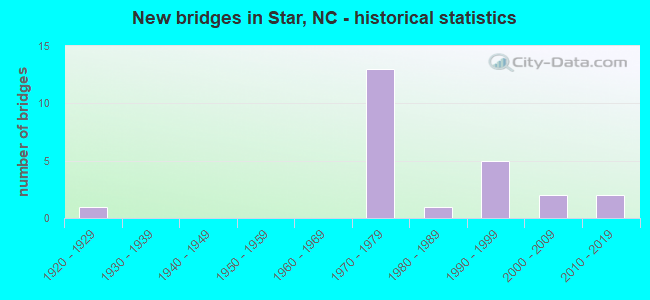
- New bridges - historical statistics
- 11920-1929
- 131970-1979
- 11980-1989
- 51990-1999
- 22000-2009
- 22010-2019


- Bridge Condition - Deck
- 10.0%Very good
- 50.0%Good
- 10.0%Satisfactory
- 30.0%Fair

- Bridge Condition - Superstructure
- 30.0%Very good
- 50.0%Good
- 10.0%Satisfactory
- 10.0%Fair

- Bridge Condition - Substructure
- 30.0%Very good
- 60.0%Good
- 10.0%Fair

- Bridge Condition - Channel
- 66.7%Good
- 33.3%Fair

- Bridge Condition - Culverts
- 50.0%Very good
- 25.0%Good
- 25.0%Fair
Find on map >> Show street view
Structure Number: 1230002, Location: 0.4 MI. E. JCT. SR1609 (Lat: 35.270603, Lng: -79.727164), Route carried "on" structure: State highway 1520, Year Built: 1977, Status: Open, Structure Length: 7.95m (26.08ft), Average Daily Traffic: 700 (year 2018), Truck Traffic: 6%, Average Future Daily Traffic: 1,400 (year 2040), Design Load: HS 15, Features Intersected: I73/74,US220
Minimum Vertical Clearance: 30+ m (98+ ft), Kilometerpoint: 0.000, Lanes on structure: 2, Lanes under structure: 4, Owner: State Highway Agency, Approaching Roadway Width: 7.0m (23.0ft), Skew: 1 degrees, Material/Design: Steel, Design/Construction: Stringer/Multi-beam, Number Of Spans In Main Unit: 4, Number Of Approach Spans: 2, Length of Maximum Span: 30.1m (98.8ft), Curb-To-Curb Width: 10.1m (33.1ft), Out-to-Out Width: 10.9m (35.8ft)
Condition: Deck: Good, Superstructure: Good, Substructure: Good, Operating Rating: 73.4 metric tons, Method Used To Determine Operating Rating: Load Factor (LF), Inventory Rating: 43.5 metric tons, Method Used To Determine Inventory Rating: Load Factor (LF), Structural Evaluation: Better than present minimum criteria, Deck Geometry: Equal to present minimum criteria, Underclear: Somewhat better than minimum adequacy, Approach Roadway Alignment: Equal to present desirable criteria, Designated Inspection Frequency: Every 24 months, Inspection Date: December 2021, Deck Structure Type: Concrete Cast-file-Place, Wearing Surface/Protective System: Wearing Surface: Monolithic Concrete
Find on map >> Show street view
Structure Number: 1230009, Location: 0.5 MI. N. JCT. SR1340 (Lat: 35.402111, Lng: -79.784156), Route carried "on" structure: Alternate US 220, Year Built: 1929, Year Reconstructed: 1940, Status: Open, Structure Length: 2.49m (8.17ft), Average Daily Traffic: 3,800 (year 2019), Truck Traffic: 7%, Average Future Daily Traffic: 7,600 (year 2040), Design Load: H 15, Features Intersected: ACW RR
Minimum Vertical Clearance: 30+ m (98+ ft), Kilometerpoint: 0.000, Lanes on structure: 2, Owner: State Highway Agency, Approaching Roadway Width: 11.2m (36.7ft), Skew: 1 degrees, Material/Design: Concrete, Design/Construction: Tee Beam, Number Of Spans In Main Unit: 3, Length of Maximum Span: 9.4m (30.8ft), Curb or Sidewalk Widths: Left: 1.5m (4.9ft), Right: 1.5m (4.9ft), Curb-To-Curb Width: 10.9m (35.8ft), Out-to-Out Width: 14.7m (48.2ft)
Condition: Deck: Fair, Superstructure: Fair, Substructure: Fair, Operating Rating: 55.3 metric tons, Method Used To Determine Operating Rating: Load Factor (LF), Inventory Rating: 33.5 metric tons, Method Used To Determine Inventory Rating: Load Factor (LF), Structural Evaluation: Somewhat better than minimum adequacy, Deck Geometry: Somewhat better than minimum adequacy, Underclear: Somewhat better than minimum adequacy, Approach Roadway Alignment: Equal to present desirable criteria, Designated Inspection Frequency: Every 24 months, Inspection Date: September 2021, Deck Structure Type: Concrete Cast-file-Place, Wearing Surface/Protective System: Wearing Surface: Bituminous
Find on map >> Show street view
Structure Number: 1230037, Location: 0.4 MI. W. JCT. SR1371 (Lat: 35.387739, Lng: -79.766781), Route carried "on" structure: State highway 1369, Year Built: 1977, Status: Open, Structure Length: 11.30m (37.07ft), Average Daily Traffic: 170 (year 2016), Truck Traffic: 6%, Average Future Daily Traffic: 340 (year 2040), Design Load: HS 15, Features Intersected: I73/74,US220
Minimum Vertical Clearance: 30+ m (98+ ft), Kilometerpoint: 0.000, Lanes on structure: 2, Lanes under structure: 4, Owner: State Highway Agency, Approaching Roadway Width: 7.6m (24.9ft), Skew: 2 degrees, Material/Design: Steel continuous, Design/Construction: Stringer/Multi-beam, Number Of Spans In Main Unit: 3, Number Of Approach Spans: 2, Length of Maximum Span: 32.9m (107.9ft), Curb-To-Curb Width: 10.8m (35.4ft), Out-to-Out Width: 11.7m (38.4ft)
Condition: Deck: Fair, Superstructure: Good, Substructure: Good, Operating Rating: 55.3 metric tons, Method Used To Determine Operating Rating: Load Factor (LF), Inventory Rating: 32.6 metric tons, Method Used To Determine Inventory Rating: Load Factor (LF), Structural Evaluation: Better than present minimum criteria, Deck Geometry: Better than present minimum criteria, Underclear: Equal to present minimum criteria, Approach Roadway Alignment: Equal to present desirable criteria, Designated Inspection Frequency: Every 24 months, Inspection Date: May 2021, Deck Structure Type: Concrete Cast-file-Place, Wearing Surface/Protective System: Wearing Surface: Monolithic Concrete
Find on map >> Show street view
Structure Number: 1230043, Location: 0.8 MI. E. JCT. US220A (Lat: 35.407869, Lng: -79.769481), Route carried "on" structure: State highway 1002, Year Built: 1976, Status: Open, Structure Length: 8.47m (27.79ft), Average Daily Traffic: 1,700 (year 2018), Truck Traffic: 6%, Average Future Daily Traffic: 3,400 (year 2040), Design Load: HS 15, Features Intersected: I73, I74, US220
Minimum Vertical Clearance: 30+ m (98+ ft), Kilometerpoint: 0.000, Lanes on structure: 2, Lanes under structure: 4, Owner: State Highway Agency, Approaching Roadway Width: 9.1m (29.9ft), Skew: 1 degrees, Material/Design: Steel, Design/Construction: Stringer/Multi-beam, Number Of Spans In Main Unit: 4, Length of Maximum Span: 30.4m (99.7ft), Curb-To-Curb Width: 17.7m (58.1ft), Out-to-Out Width: 19.0m (62.3ft)
Condition: Deck: Fair, Superstructure: Good, Substructure: Good, Operating Rating: 76.2 metric tons, Method Used To Determine Operating Rating: Load Factor (LF), Inventory Rating: 45.3 metric tons, Method Used To Determine Inventory Rating: Load Factor (LF), Structural Evaluation: Better than present minimum criteria, Deck Geometry: Superior to present desirable criteria, Underclear: Somewhat better than minimum adequacy, Approach Roadway Alignment: Equal to present desirable criteria, Designated Inspection Frequency: Every 24 months, Inspection Date: September 2021, Deck Structure Type: Concrete Cast-file-Place, Wearing Surface/Protective System: Wearing Surface: Monolithic Concrete
Find on map >> Show street view
Structure Number: 1230048, Location: 0.7 MI. E. JCT. US220A (Lat: 35.419833, Lng: -79.771661), Route carried "on" structure: State highway 1365, Year Built: 1978, Status: Open, Structure Length: 7.80m (25.59ft), Average Daily Traffic: 670 (year 2016), Truck Traffic: 6%, Average Future Daily Traffic: 1,340 (year 2040), Design Load: HS 15, Features Intersected: I73, I74, US220
Minimum Vertical Clearance: 30+ m (98+ ft), Kilometerpoint: 0.000, Lanes on structure: 2, Lanes under structure: 4, Owner: State Highway Agency, Approaching Roadway Width: 10.6m (34.8ft), Material/Design: Steel, Design/Construction: Stringer/Multi-beam, Number Of Spans In Main Unit: 2, Length of Maximum Span: 39.6m (129.9ft), Curb-To-Curb Width: 10.7m (35.1ft), Out-to-Out Width: 11.7m (38.4ft)
Condition: Deck: Satisfactory, Superstructure: Satisfactory, Substructure: Good, Operating Rating: 89.8 metric tons, Method Used To Determine Operating Rating: Load Factor (LF), Inventory Rating: 58.0 metric tons, Method Used To Determine Inventory Rating: Load Factor (LF), Structural Evaluation: Equal to present minimum criteria, Deck Geometry: Equal to present minimum criteria, Underclear: Equal to present minimum criteria, Approach Roadway Alignment: Equal to present desirable criteria, Designated Inspection Frequency: Every 24 months, Inspection Date: December 2021, Deck Structure Type: Concrete Cast-file-Place, Wearing Surface/Protective System: Wearing Surface: Monolithic Concrete
Find on map >> Show street view
Structure Number: 1230051, Location: 0.4 MI. E. JCT. US220A (Lat: 35.439725, Lng: -79.775583), Route carried "on" structure: State highway 1363, Year Built: 1977, Status: Open, Structure Length: 8.01m (26.28ft), Average Daily Traffic: 270 (year 2016), Truck Traffic: 6%, Average Future Daily Traffic: 540 (year 2040), Design Load: HS 15, Features Intersected: I73,I74,US220
Minimum Vertical Clearance: 30+ m (98+ ft), Kilometerpoint: 0.000, Lanes on structure: 2, Lanes under structure: 4, Owner: State Highway Agency, Approaching Roadway Width: 7.3m (24.0ft), Material/Design: Steel, Design/Construction: Stringer/Multi-beam, Number Of Spans In Main Unit: 4, Length of Maximum Span: 29.8m (97.8ft), Curb-To-Curb Width: 10.8m (35.4ft), Out-to-Out Width: 11.7m (38.4ft)
Condition: Deck: Good, Superstructure: Good, Substructure: Good, Operating Rating: 59.8 metric tons, Method Used To Determine Operating Rating: Load Factor (LF), Inventory Rating: 36.2 metric tons, Method Used To Determine Inventory Rating: Load Factor (LF), Structural Evaluation: Better than present minimum criteria, Deck Geometry: Better than present minimum criteria, Underclear: Equal to present minimum criteria, Approach Roadway Alignment: Equal to present desirable criteria, Designated Inspection Frequency: Every 24 months, Inspection Date: September 2021, Deck Structure Type: Concrete Cast-file-Place, Wearing Surface/Protective System: Wearing Surface: Monolithic Concrete
Find on map >> Show street view
Structure Number: 1230115, Location: 0.5 MI. N. JCT. SR1002 (Lat: 35.412336, Lng: -79.744117), Route carried "on" structure: State highway 1363, Year Built: 1998, Status: Open, Structure Length: 0.88m (2.89ft), Average Daily Traffic: 140 (year 2018), Truck Traffic: 6%, Average Future Daily Traffic: 280 (year 2040), Design Load: HS 20+Mod, Features Intersected: WOLF CREEK
Minimum Vertical Clearance: 30+ m (98+ ft), Kilometerpoint: 0.000, Lanes on structure: 2, Owner: State Highway Agency, Approaching Roadway Width: 5.4m (17.7ft), Material/Design: Steel, Design/Construction: Culvert, Number Of Spans In Main Unit: 2, Length of Maximum Span: 3.6m (11.8ft)
Condition: Channel: Good, Culverts: Good, Operating Rating: 89.8 metric tons, Method Used To Determine Operating Rating: Load and Resistance Factor (LRFR), Inventory Rating: 89.8 metric tons, Method Used To Determine Inventory Rating: Load and Resistance Factor (LRFR), Structural Evaluation: Better than present minimum criteria, Waterway Adequacy: Equal to present minimum criteria, Approach Roadway Alignment: Equal to present desirable criteria, Designated Inspection Frequency: Every 24 months, Inspection Date: April 2020
Find on map >> Show street view
Structure Number: 1230117, Location: 0.2 MI. N. JCT. SR1367 (Lat: 35.421819, Lng: -79.763864), Route carried "on" structure: State highway 1365, Year Built: 2002, Status: Open, Structure Length: 0.64m (2.10ft), Average Daily Traffic: 630 (year 2016), Truck Traffic: 6%, Average Future Daily Traffic: 1,260 (year 2040), Design Load: HS 20+Mod, Features Intersected: WOLF CREEK
Minimum Vertical Clearance: 30+ m (98+ ft), Kilometerpoint: 0.000, Lanes on structure: 2, Owner: State Highway Agency, Approaching Roadway Width: 6.4m (21.0ft), Material/Design: Aluminum, Iron, Design/Construction: Culvert, Number Of Spans In Main Unit: 1, Length of Maximum Span: 6.4m (21.0ft)
Condition: Channel: Fair, Culverts: Very good, Operating Rating: 44.4 metric tons, Method Used To Determine Operating Rating: Load and Resistance Factor (LRFR), Inventory Rating: 44.4 metric tons, Method Used To Determine Inventory Rating: Load and Resistance Factor (LRFR), Structural Evaluation: Equal to present desirable criteria, Waterway Adequacy: Better than present minimum criteria, Approach Roadway Alignment: Equal to present desirable criteria, Designated Inspection Frequency: Every 24 months, Inspection Date: September 2021
Find on map >> Show street view
Structure Number: 1230118, Location: 0.1 MI. S. JCT. SR1350 (Lat: 35.451597, Lng: -79.805589), Route carried "on" structure: State highway 1349, Year Built: 1981, Status: Open, Structure Length: 7.98m (26.18ft), Average Daily Traffic: 520 (year 2018), Truck Traffic: 6%, Average Future Daily Traffic: 1,040 (year 2040), Design Load: HS 20+Mod, Features Intersected: LITTLE RIVER
Minimum Vertical Clearance: 30+ m (98+ ft), Kilometerpoint: 0.000, Lanes on structure: 2, Owner: State Highway Agency, Approaching Roadway Width: 6.7m (22.0ft), Skew: 1 degrees, Material/Design: Prestressed concrete, Design/Construction: Stringer/Multi-beam, Number Of Spans In Main Unit: 3, Length of Maximum Span: 25.9m (85.0ft), Curb-To-Curb Width: 8.5m (27.9ft), Out-to-Out Width: 9.4m (30.8ft)
Condition: Deck: Good, Superstructure: Good, Substructure: Good, Channel: Good, Operating Rating: 89.8 metric tons, Method Used To Determine Operating Rating: Load Factor (LF), Inventory Rating: 36.2 metric tons, Method Used To Determine Inventory Rating: Load Factor (LF), Structural Evaluation: Better than present minimum criteria, Deck Geometry: Somewhat better than minimum adequacy, Waterway Adequacy: Superior to present desirable criteria, Approach Roadway Alignment: Equal to present desirable criteria, Designated Inspection Frequency: Every 24 months, Inspection Date: December 2021, Deck Structure Type: Concrete Cast-file-Place, Wearing Surface/Protective System: Wearing Surface: Monolithic Concrete
Find on map >> Show street view
Structure Number: 1230184, Location: 1.2 MI. N. JCT. SR1340 (Lat: 35.402981, Lng: -79.816822), Route carried "on" structure: State highway 1343, Year Built: 2000, Status: Open, Structure Length: 0.79m (2.59ft), Average Daily Traffic: 500 (year 2018), Truck Traffic: 6%, Average Future Daily Traffic: 1,000 (year 2040), Design Load: HS 20+Mod, Features Intersected: WHITE OAK CREEK
Minimum Vertical Clearance: 30+ m (98+ ft), Kilometerpoint: 0.000, Lanes on structure: 2, Owner: State Highway Agency, Approaching Roadway Width: 6.4m (21.0ft), Skew: 2 degrees, Material/Design: Aluminum, Iron, Design/Construction: Culvert, Number Of Spans In Main Unit: 1, Length of Maximum Span: 7.0m (23.0ft)
Condition: Channel: Fair, Culverts: Fair, Operating Rating: 38.1 metric tons, Method Used To Determine Operating Rating: Load and Resistance Factor (LRFR), Inventory Rating: 38.1 metric tons, Method Used To Determine Inventory Rating: Load and Resistance Factor (LRFR), Structural Evaluation: Somewhat better than minimum adequacy, Waterway Adequacy: Better than present minimum criteria, Approach Roadway Alignment: Equal to present desirable criteria, Designated Inspection Frequency: Every 24 months, Inspection Date: December 2020
Find on map >> Show street view
Structure Number: 1230207, Location: 0.8 MI. N. JCT. SR1002 (Lat: 35.416933, Lng: -79.761122), Route carried "on" structure: State highway 1367, Year Built: 2013, Status: Open, Structure Length: 0.73m (2.40ft), Average Daily Traffic: 220 (year 2015), Truck Traffic: 6%, Average Future Daily Traffic: 440 (year 2040), Design Load: HL 93, Features Intersected: WOLF CREEK
Minimum Vertical Clearance: 30+ m (98+ ft), Kilometerpoint: 0.000, Lanes on structure: 2, Owner: State Highway Agency, Approaching Roadway Width: 5.4m (17.7ft), Material/Design: Aluminum, Iron, Design/Construction: Culvert, Number Of Spans In Main Unit: 1, Length of Maximum Span: 7.3m (24.0ft)
Condition: Channel: Good, Culverts: Very good, Operating Rating: 58.0 metric tons, Method Used To Determine Operating Rating: Load and Resistance Factor (LRFR), Inventory Rating: 58.0 metric tons, Method Used To Determine Inventory Rating: Load and Resistance Factor (LRFR), Structural Evaluation: Equal to present desirable criteria, Waterway Adequacy: Better than present minimum criteria, Approach Roadway Alignment: Equal to present desirable criteria, Designated Inspection Frequency: Every 24 months, Inspection Date: July 2021
Find on map >> Show street view
Structure Number: 1230243, Location: 0.8 MI. S. JCT. SR1348 (Lat: 35.451569, Lng: -79.780739), Route carried "on" structure: Interstate 73, Year Built: 1994, Status: Open, Structure Length: 6.33m (20.77ft), Average Daily Traffic: 7,750 (year 2018), Truck Traffic: 23%, Average Future Daily Traffic: 15,500 (year 2040), Design Load: HS 20+Mod, Features Intersected: US220A
Minimum Vertical Clearance: 30+ m (98+ ft), Kilometerpoint: 11.856, Lanes on structure: 2, Lanes under structure: 3, Base Highway Network: Yes (Inventory Route: 1, Subroute: 73), Owner: State Highway Agency, Approaching Roadway Width: 11.5m (37.7ft), Skew: 15 degrees, Material/Design: Steel, Design/Construction: Stringer/Multi-beam, Number Of Spans In Main Unit: 3, Length of Maximum Span: 31.0m (101.7ft), Curb-To-Curb Width: 11.4m (37.4ft), Out-to-Out Width: 12.4m (40.7ft)
Condition: Deck: Good, Superstructure: Very good, Substructure: Very good, Operating Rating: 83.4 metric tons, Method Used To Determine Operating Rating: Load Factor (LF), Inventory Rating: 49.8 metric tons, Method Used To Determine Inventory Rating: Load Factor (LF), Structural Evaluation: Equal to present desirable criteria, Deck Geometry: Somewhat better than minimum adequacy, Underclear: Somewhat better than minimum adequacy, Approach Roadway Alignment: Equal to present desirable criteria, Designated Inspection Frequency: Every 24 months, Inspection Date: May 2020, Deck Structure Type: Concrete Cast-file-Place, Wearing Surface/Protective System: Wearing Surface: Monolithic Concrete, Deck Protection: Epoxy Coated Reinforcing
Find on map >> Show street view
Structure Number: 1230244, Location: 0.8 MI. S. JCT. SR1348 (Lat: 35.452003, Lng: -79.780586), Route carried "on" structure: Interstate 73, Year Built: 1994, Status: Open, Structure Length: 6.40m (21.00ft), Average Daily Traffic: 7,750 (year 2018), Truck Traffic: 23%, Average Future Daily Traffic: 15,500 (year 2040), Design Load: HS 20+Mod, Features Intersected: US220A
Minimum Vertical Clearance: 30+ m (98+ ft), Kilometerpoint: 11.856, Lanes on structure: 2, Lanes under structure: 3, Base Highway Network: Yes (Inventory Route: 1, Subroute: 73), Owner: State Highway Agency, Approaching Roadway Width: 11.5m (37.7ft), Skew: 15 degrees, Material/Design: Steel, Design/Construction: Stringer/Multi-beam, Number Of Spans In Main Unit: 3, Length of Maximum Span: 31.0m (101.7ft), Curb-To-Curb Width: 11.4m (37.4ft), Out-to-Out Width: 12.4m (40.7ft)
Condition: Deck: Good, Superstructure: Very good, Substructure: Very good, Operating Rating: 79.8 metric tons, Method Used To Determine Operating Rating: Load Factor (LF), Inventory Rating: 48.0 metric tons, Method Used To Determine Inventory Rating: Load Factor (LF), Structural Evaluation: Equal to present desirable criteria, Deck Geometry: Somewhat better than minimum adequacy, Underclear: Somewhat better than minimum adequacy, Approach Roadway Alignment: Equal to present desirable criteria, Designated Inspection Frequency: Every 24 months, Inspection Date: May 2020, Deck Structure Type: Concrete Cast-file-Place, Wearing Surface/Protective System: Wearing Surface: Monolithic Concrete, Deck Protection: Epoxy Coated Reinforcing
Find on map >> Show street view
Structure Number: 1250184, Location: 0.9 MI. N. JCT. SR1405 (Lat: 35.443847, Lng: -79.745214), Route carried "on" structure: State highway 1404, Year Built: 2011, Status: Open, Structure Length: 2.49m (8.17ft), Average Daily Traffic: 250 (year 2015), Truck Traffic: 6%, Average Future Daily Traffic: 500 (year 2025), Design Load: HL 93, Features Intersected: WILLIAMS CREEK
Minimum Vertical Clearance: 30+ m (98+ ft), Kilometerpoint: 0.000, Lanes on structure: 2, Owner: State Highway Agency, Approaching Roadway Width: 8.2m (26.9ft), Material/Design: Prestressed concrete, Design/Construction: Slab, Number Of Spans In Main Unit: 2, Length of Maximum Span: 16.4m (53.8ft), Curb-To-Curb Width: 8.3m (27.2ft), Out-to-Out Width: 9.1m (29.9ft)
Condition: Deck: Very good, Superstructure: Very good, Substructure: Very good, Channel: Good, Operating Rating: 48.9 metric tons, Method Used To Determine Operating Rating: Load and Resistance Factor (LRFR), Inventory Rating: 38.1 metric tons, Method Used To Determine Inventory Rating: Load and Resistance Factor (LRFR), Structural Evaluation: Equal to present desirable criteria, Deck Geometry: Somewhat better than minimum adequacy, Waterway Adequacy: Better than present minimum criteria, Approach Roadway Alignment: Equal to present desirable criteria, Designated Inspection Frequency: Every 24 months, Inspection Date: January 2022, Deck Structure Type: Concrete Precast Panels, Wearing Surface/Protective System: Wearing Surface: Bituminous
Find on map >> Show street view
Structure Number: 1230037, Location: 0.4 MI. W. JCT. SR1371 (Lat: 35.387739, Lng: -79.766781), Route carried "under" structure: Interstate 73, Year Built: 1977, Structure Length: 0. m, Average Daily Traffic: 9,000 (year 2019), Truck Traffic: 23%, Features Intersected: SR1369
Minimum Vertical Clearance: 5.18m (16.99ft), Kilometerpoint: 10.454, Lanes on structure: 2, Lanes under structure: 2, Material/Design: Steel continuous, Design/Construction: Stringer/Multi-beam, Length of Maximum Span: 32.9m (107.9ft)
Find on map >> Show street view
Structure Number: 1230037, Location: 0.4 MI. W. JCT. SR1371 (Lat: 35.387739, Lng: -79.766781), Route carried "under" structure: Interstate 73, Year Built: 1977, Structure Length: 0. m, Average Daily Traffic: 9,000 (year 2019), Truck Traffic: 23%, Features Intersected: SR1369
Minimum Vertical Clearance: 5.15m (16.90ft), Kilometerpoint: 10.454, Lanes on structure: 2, Lanes under structure: 2, Material/Design: Steel continuous, Design/Construction: Stringer/Multi-beam, Length of Maximum Span: 32.9m (107.9ft)
Find on map >> Show street view
Structure Number: 1230043, Location: 0.8 MI. E. JCT. US220A (Lat: 35.407869, Lng: -79.769481), Route carried "under" structure: Interstate 73, Year Built: 1976, Structure Length: 0. m, Average Daily Traffic: 9,000 (year 2019), Truck Traffic: 23%, Features Intersected: SR1002
Minimum Vertical Clearance: 5.20m (17.06ft), Kilometerpoint: 0.000, Lanes on structure: 2, Lanes under structure: 2, Material/Design: Steel, Design/Construction: Stringer/Multi-beam, Length of Maximum Span: 30.4m (99.7ft)
Find on map >> Show street view
Structure Number: 1230043, Location: 0.8 MI. E. JCT. US220A (Lat: 35.407869, Lng: -79.769481), Route carried "under" structure: Interstate 73, Year Built: 1976, Structure Length: 0. m, Average Daily Traffic: 9,000 (year 2019), Truck Traffic: 23%, Features Intersected: SR1002
Minimum Vertical Clearance: 5.05m (16.57ft), Kilometerpoint: 0.000, Lanes on structure: 2, Lanes under structure: 2, Material/Design: Steel, Design/Construction: Stringer/Multi-beam, Length of Maximum Span: 30.4m (99.7ft)
Find on map >> Show street view
Structure Number: 1230048, Location: 0.7 MI. E. JCT. US220A (Lat: 35.419833, Lng: -79.771661), Route carried "under" structure: Interstate 73, Year Built: 1978, Structure Length: 0. m, Average Daily Traffic: 8,750 (year 2019), Truck Traffic: 23%, Features Intersected: SR1365
Minimum Vertical Clearance: 5.06m (16.60ft), Kilometerpoint: 16.276, Lanes on structure: 2, Lanes under structure: 2, Material/Design: Steel, Design/Construction: Stringer/Multi-beam, Length of Maximum Span: 39.6m (129.9ft)
Find on map >> Show street view
Structure Number: 1230048, Location: 0.7 MI. E. JCT. US220A (Lat: 35.419833, Lng: -79.771661), Route carried "under" structure: Interstate 73, Year Built: 1978, Structure Length: 0. m, Average Daily Traffic: 8,750 (year 2019), Truck Traffic: 23%, Features Intersected: SR1365
Minimum Vertical Clearance: 5.98m (19.62ft), Kilometerpoint: 16.276, Lanes on structure: 2, Lanes under structure: 2, Material/Design: Steel, Design/Construction: Stringer/Multi-beam, Length of Maximum Span: 39.6m (129.9ft)
Find on map >> Show street view
Structure Number: 1230051, Location: 0.4 MI. E. JCT. US220A (Lat: 35.439725, Lng: -79.775583), Route carried "under" structure: Interstate 73, Year Built: 1977, Structure Length: 0. m, Average Daily Traffic: 8,750 (year 2019), Truck Traffic: 23%, Features Intersected: SR1363
Minimum Vertical Clearance: 5.05m (16.57ft), Kilometerpoint: 0.000, Lanes on structure: 2, Lanes under structure: 2, Material/Design: Steel, Design/Construction: Stringer/Multi-beam, Length of Maximum Span: 29.8m (97.8ft)
Find on map >> Show street view
Structure Number: 1230051, Location: 0.4 MI. E. JCT. US220A (Lat: 35.439725, Lng: -79.775583), Route carried "under" structure: Interstate 73, Year Built: 1977, Structure Length: 0. m, Average Daily Traffic: 8,750 (year 2019), Truck Traffic: 23%, Features Intersected: SR1363
Minimum Vertical Clearance: 5.35m (17.55ft), Kilometerpoint: 0.000, Lanes on structure: 2, Lanes under structure: 2, Material/Design: Steel, Design/Construction: Stringer/Multi-beam, Length of Maximum Span: 29.8m (97.8ft)
Find on map >> Show street view
Structure Number: 1230243, Location: 0.8 MI. S. JCT. SR1348 (Lat: 35.451569, Lng: -79.780739), Route carried "under" structure: Alternate US 220, Year Built: 1994, Structure Length: 0. m, Average Daily Traffic: 1,500 (year 2016), Truck Traffic: 7%, Features Intersected: I73S,I74E, US220 S
Minimum Vertical Clearance: 4.64m (15.22ft), Kilometerpoint: 0.000, Lanes on structure: 2, Lanes under structure: 3, Material/Design: Steel, Design/Construction: Stringer/Multi-beam, Length of Maximum Span: 31.0m (101.7ft)
Find on map >> Show street view
Structure Number: 1230244, Location: 0.8 MI. S. JCT. SR1348 (Lat: 35.452003, Lng: -79.780586), Route carried "under" structure: Alternate US 220, Year Built: 1994, Structure Length: 0. m, Average Daily Traffic: 1,500 (year 2016), Truck Traffic: 7%, Features Intersected: I73N, I74W,US220N
Minimum Vertical Clearance: 4.72m (15.49ft), Kilometerpoint: 0.000, Lanes on structure: 2, Lanes under structure: 3, Material/Design: Steel, Design/Construction: Stringer/Multi-beam, Length of Maximum Span: 31.0m (101.7ft)