Bridge Statistics for Start, Louisiana (LA)
Condition, Traffic, Stress, Structural Evaluation, Project Costs
- National Bridge Inventory (NBI) Statistics
- 30Number of bridges
- 495ft / 151mTotal length
- $2,696,000Total costs
- 216,920Total average daily traffic
- 69,190Total average daily truck traffic
- National Bridge Inventory (NBI) Registered Bridges for Start
- No street view available for this location
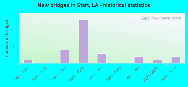
- New bridges - historical statistics
- 11930-1939
- 41950-1959
- 131960-1969
- 31970-1979
- 21990-1999
- 12000-2009
- 22010-2019


- Bridge Condition - Deck
- 78.3%Satisfactory
- 13.0%Fair
- 8.7%Failed

- Bridge Condition - Superstructure
- 17.4%Good
- 60.9%Satisfactory
- 13.0%Fair
- 8.7%Failed

- Bridge Condition - Substructure
- 21.7%Good
- 47.8%Satisfactory
- 17.4%Fair
- 4.3%Imminent failure
- 8.7%Failed

- Bridge Condition - Channel
- 8.3%Good
- 79.2%Satisfactory
- 8.3%Poor
- 4.2%Failed

- Bridge Condition - Culverts
- 66.7%Good
- 33.3%Satisfactory
Find on map >> Show street view
Structure Number: 53432316914751, Location: 8.9 MI SW of LA 134 (Lat: 32.526339, Lng: -91.871261), Route carried "on" structure: County highway , Year Built: 1999, Status: Open, Structure Length: 7.53m (24.70ft), Average Daily Traffic: 280 (year 1979), Average Future Daily Traffic: 168 (year 2036), Design Load: HS 20, Features Intersected: LITTLE LAKE LAFOURCHE, Facility Carried by Structure: LAKE IRWIN RD
Minimum Vertical Clearance: 30+ m (98+ ft), Kilometerpoint: 0.000, Lanes on structure: 2, Base Highway Network: Yes, Owner: County Highway Agency, Approaching Roadway Width: 6.1m (20.0ft), Material/Design: Concrete, Design/Construction: Slab, Number Of Spans In Main Unit: 13, Length of Maximum Span: 5.8m (19.0ft), Curb-To-Curb Width: 7.3m (24.0ft), Out-to-Out Width: 8.2m (26.9ft)
Condition: Deck: Satisfactory, Superstructure: Satisfactory, Substructure: Good, Channel: Satisfactory, Operating Rating: 54.8 metric tons, Method Used To Determine Operating Rating: Load and Resistance Factor Rating (LRFR) rating reported by rating factor(RF) method using HL-93 loadings, Inventory Rating: 42.1 metric tons, Method Used To Determine Inventory Rating: Load and Resistance Factor Rating (LRFR) rating reported by rating factor(RF) method using HL-93 loadings, Structural Evaluation: Equal to present minimum criteria, Deck Geometry: Somewhat better than minimum adequacy, Waterway Adequacy: Equal to present desirable criteria, Approach Roadway Alignment: Equal to present minimum criteria, Designated Inspection Frequency: Every 24 months, Underwater Inspection Frequency: Every 60 months, Inspection Date: September 2020, Underwater Inspection Date: Febuary 2018, Deck Structure Type: Concrete Cast-file-Place
Find on map >> Show street view
Structure Number: 53432337915031, Location: 3.2 MI. NE INT. 505 (Lat: 32.556339, Lng: -91.841111), Route carried "on" structure: County highway , Year Built: 1978, Status: Closed, Structure Length: 11.67m (38.29ft), Average Daily Traffic: 150 (year 1974), Average Future Daily Traffic: 90 (year 2036), Design Load: HS 20, Features Intersected: IRWIN LAKE, Facility Carried by Structure: LAKE IRWIN RD
Minimum Vertical Clearance: 30+ m (98+ ft), Kilometerpoint: 0.000, Lanes on structure: 2, Owner: County Highway Agency, Approaching Roadway Width: 9.1m (29.9ft), Material/Design: Steel, Design/Construction: Stringer/Multi-beam, Number Of Spans In Main Unit: 16, Length of Maximum Span: 17.4m (57.1ft), Curb-To-Curb Width: 7.0m (23.0ft), Out-to-Out Width: 7.3m (24.0ft)
Condition: Deck: Fair, Superstructure: Fair, Substructure: Imminent failure, Channel: Poor, Deck Geometry: Meets minimum limits, Waterway Adequacy: Equal to present desirable criteria, Approach Roadway Alignment: High priority of corrective action, Bridge Posting: Required (Relationship of Operating Rating to Maximum Legal Load: > 39.9% below), Length Of Structure Improvement: 12.59m (41.31ft), Designated Inspection Frequency: Every 24 months, Critical Feature Inspection Frequency: Every 24 months, Underwater Inspection Frequency: Every 60 months, Other Special Inspection Frequency: Every 6 months, Inspection Date: October 2020, Critical Feature Inspection Date: October 2020, Underwater Inspection Date: June 2018, Other Special Inspection Date: September 2021, Bridge Improvement Cost: $751,000, Total Project Cost: $1,126,000 ( Estimate for 2016), Deck Structure Type: Wood or Timber, Wearing Surface/Protective System: Wearing Surface: Bituminous
Find on map >> Show street view
Structure Number: 53700020109381, Location: 3.6 MI EAST OF LA 594 (Lat: 32.509339, Lng: -91.931800), Route carried "on" structure: US 80, Year Built: 1955, Status: Open, Structure Length: 9.75m (31.99ft), Average Daily Traffic: 5,700 (year 2016), Truck Traffic: 15%, Average Future Daily Traffic: 3,720 (year 2036), Design Load: HS 20, Features Intersected: WEST RELIEF
Minimum Vertical Clearance: 30+ m (98+ ft), Kilometerpoint: 15.076, Lanes on structure: 2, Owner: State Highway Agency, Approaching Roadway Width: 11.0m (36.1ft), Material/Design: Concrete, Design/Construction: Slab, Number Of Spans In Main Unit: 16, Length of Maximum Span: 6.1m (20.0ft), Curb-To-Curb Width: 8.5m (27.9ft), Out-to-Out Width: 10.2m (33.5ft)
Condition: Deck: Satisfactory, Superstructure: Satisfactory, Substructure: Satisfactory, Channel: Satisfactory, Operating Rating: 35.4 metric tons, Method Used To Determine Operating Rating: Load Factor (LF), Inventory Rating: 20.9 metric tons, Method Used To Determine Inventory Rating: Load Factor (LF), Structural Evaluation: Somewhat better than minimum adequacy, Deck Geometry: Meets minimum limits, Waterway Adequacy: Equal to present desirable criteria, Approach Roadway Alignment: Equal to present desirable criteria, Designated Inspection Frequency: Every 24 months, Inspection Date: August 2020, Deck Structure Type: Concrete Cast-file-Place, Wearing Surface/Protective System: Wearing Surface: Bituminous
Find on map >> Show street view
Structure Number: 54200000050235, Location: 3.6 MI W OF LA 133 (Lat: 32.500589, Lng: -91.918731), Route carried "on" structure: US 80, Year Built: 2017, Status: Open, Structure Length: 17.07m (56.00ft), Average Daily Traffic: 1,480 (year 2016), Truck Traffic: 15%, Average Future Daily Traffic: 3,000 (year 2034), Design Load: Greater than HL93, Features Intersected: LAFOURCHE BAYOU
Minimum Vertical Clearance: 30+ m (98+ ft), Kilometerpoint: 0.013, Lanes on structure: 2, Owner: State Highway Agency, Approaching Roadway Width: 7.3m (24.0ft), Material/Design: Prestressed concrete, Design/Construction: Box Beam or Girders - Multiple, Number Of Spans In Main Unit: 7, Length of Maximum Span: 24.4m (80.1ft), Curb-To-Curb Width: 12.0m (39.4ft), Out-to-Out Width: 13.0m (42.7ft)
Condition: Deck: Satisfactory, Superstructure: Good, Substructure: Good, Channel: Good, Operating Rating: 59.3 metric tons, Method Used To Determine Operating Rating: Load and Resistance Factor Rating (LRFR) rating reported by rating factor(RF) method using HL-93 loadings, Inventory Rating: 45.7 metric tons, Method Used To Determine Inventory Rating: Load and Resistance Factor Rating (LRFR) rating reported by rating factor(RF) method using HL-93 loadings, Structural Evaluation: Better than present minimum criteria, Deck Geometry: Equal to present minimum criteria, Waterway Adequacy: Equal to present desirable criteria, Approach Roadway Alignment: Equal to present desirable criteria, Designated Inspection Frequency: Every 24 months, Inspection Date: August 2021, Deck Structure Type: Concrete Precast Panels, Wearing Surface/Protective System: Deck Protection: Epoxy Coated Reinforcing
Find on map >> Show street view
Structure Number: 54200000050274, Location: 1.5 MI W OF LA 133 (Lat: 32.472911, Lng: -91.886400), Route carried "on" structure: County highway , Year Built: 2016, Status: Open, Structure Length: 0.73m (2.40ft), Average Daily Traffic: 60 (year 1974), Average Future Daily Traffic: 36 (year 2036), Design Load: HS 20, Features Intersected: CREEK, Facility Carried by Structure: BRIMBERRY RD
Minimum Vertical Clearance: 30+ m (98+ ft), Kilometerpoint: 0.000, Lanes on structure: 2, Owner: County Highway Agency, Approaching Roadway Width: 6.1m (20.0ft), Skew: 31 degrees, Material/Design: Steel, Design/Construction: Culvert, Number Of Spans In Main Unit: 4, Length of Maximum Span: 1.5m (4.9ft)
Condition: Channel: Satisfactory, Culverts: Good, Operating Rating: 34.7 metric tons, Method Used To Determine Operating Rating: Load and Resistance Factor Rating (LRFR) rating reported by rating factor(RF) method using HL-93 loadings, Inventory Rating: 26.9 metric tons, Method Used To Determine Inventory Rating: Load and Resistance Factor Rating (LRFR) rating reported by rating factor(RF) method using HL-93 loadings, Structural Evaluation: Equal to present minimum criteria, Waterway Adequacy: Better than present minimum criteria, Approach Roadway Alignment: High priority of corrective action, Designated Inspection Frequency: Every 24 months, Inspection Date: August 2021, Deck Structure Type: Other
Find on map >> Show street view
Structure Number: 54200020200411, Location: 3.2 MI WEST OF SOUTH INT (Lat: 32.496839, Lng: -91.913100), Route carried "on" structure: US 80, Year Built: 1955, Status: Open, Structure Length: 6.71m (22.01ft), Average Daily Traffic: 1,480 (year 2016), Truck Traffic: 15%, Average Future Daily Traffic: 1,320 (year 2036), Design Load: HS 20, Features Intersected: DRAIN
Minimum Vertical Clearance: 30+ m (98+ ft), Kilometerpoint: 0.661, Lanes on structure: 2, Owner: State Highway Agency, Approaching Roadway Width: 11.0m (36.1ft), Material/Design: Concrete, Design/Construction: Slab, Number Of Spans In Main Unit: 11, Length of Maximum Span: 6.1m (20.0ft), Curb-To-Curb Width: 8.5m (27.9ft), Out-to-Out Width: 10.2m (33.5ft)
Condition: Deck: Fair, Superstructure: Fair, Substructure: Fair, Channel: Satisfactory, Operating Rating: 44.4 metric tons, Method Used To Determine Operating Rating: Load Factor (LF), Inventory Rating: 26.3 metric tons, Method Used To Determine Inventory Rating: Load Factor (LF), Structural Evaluation: Somewhat better than minimum adequacy, Deck Geometry: Somewhat better than minimum adequacy, Waterway Adequacy: Better than present minimum criteria, Approach Roadway Alignment: Better than present minimum criteria, Designated Inspection Frequency: Every 24 months, Inspection Date: August 2021, Deck Structure Type: Concrete Cast-file-Place, Wearing Surface/Protective System: Wearing Surface: Bituminous
Find on map >> Show street view
Structure Number: 54200020202371, Location: .8 MI WEST OF SOUTH INT O (Lat: 32.488081, Lng: -91.883000), Route carried "on" structure: US 80, Year Built: 1953, Status: Open, Structure Length: 5.67m (18.60ft), Average Daily Traffic: 1,480 (year 2016), Truck Traffic: 15%, Average Future Daily Traffic: 1,320 (year 2036), Design Load: H 15, Features Intersected: CREW LAKE
Minimum Vertical Clearance: 30+ m (98+ ft), Kilometerpoint: 3.793, Lanes on structure: 2, Owner: State Highway Agency, Approaching Roadway Width: 9.8m (32.2ft), Material/Design: Concrete, Design/Construction: Tee Beam, Number Of Spans In Main Unit: 6, Length of Maximum Span: 9.4m (30.8ft), Curb-To-Curb Width: 8.5m (27.9ft), Out-to-Out Width: 10.2m (33.5ft)
Condition: Deck: Satisfactory, Superstructure: Satisfactory, Substructure: Fair, Channel: Satisfactory, Operating Rating: 71.7 metric tons, Method Used To Determine Operating Rating: Load Factor (LF), Inventory Rating: 42.6 metric tons, Method Used To Determine Inventory Rating: Load Factor (LF), Structural Evaluation: Somewhat better than minimum adequacy, Deck Geometry: Somewhat better than minimum adequacy, Waterway Adequacy: Equal to present desirable criteria, Approach Roadway Alignment: Equal to present desirable criteria, Designated Inspection Frequency: Every 24 months, Underwater Inspection Frequency: Every 60 months, Inspection Date: August 2021, Underwater Inspection Date: Febuary 2018, Deck Structure Type: Concrete Cast-file-Place, Wearing Surface/Protective System: Wearing Surface: Bituminous
Find on map >> Show street view
Structure Number: 54200020204421, Location: .5 MI EAST OF LA 595 (Lat: 32.484811, Lng: -91.849700), Route carried "on" structure: US 80, Year Built: 1953, Status: Open, Structure Length: 1.89m (6.20ft), Average Daily Traffic: 2,800 (year 2016), Truck Traffic: 15%, Average Future Daily Traffic: 1,980 (year 2036), Design Load: H 15, Features Intersected: STEEP BAYOU
Minimum Vertical Clearance: 30+ m (98+ ft), Kilometerpoint: 6.956, Lanes on structure: 2, Owner: State Highway Agency, Approaching Roadway Width: 9.8m (32.2ft), Material/Design: Concrete, Design/Construction: Tee Beam, Number Of Spans In Main Unit: 2, Length of Maximum Span: 9.4m (30.8ft), Curb-To-Curb Width: 8.5m (27.9ft), Out-to-Out Width: 10.2m (33.5ft)
Condition: Deck: Satisfactory, Superstructure: Satisfactory, Substructure: Satisfactory, Channel: Satisfactory, Operating Rating: 59.9 metric tons, Method Used To Determine Operating Rating: Load Factor (LF), Inventory Rating: 36.3 metric tons, Method Used To Determine Inventory Rating: Load Factor (LF), Structural Evaluation: Equal to present minimum criteria, Deck Geometry: Meets minimum limits, Waterway Adequacy: Better than present minimum criteria, Approach Roadway Alignment: Better than present minimum criteria, Designated Inspection Frequency: Every 24 months, Inspection Date: September 2021, Deck Structure Type: Concrete Cast-file-Place, Wearing Surface/Protective System: Wearing Surface: Bituminous
Find on map >> Show street view
Structure Number: 54201710306571, Location: 6.57 MI NORTH OF LA 15 (Lat: 32.457289, Lng: -91.860600), Route carried "on" structure: State highway 133, Year Built: 1970, Status: Open, Structure Length: 2.44m (8.01ft), Average Daily Traffic: 1,180 (year 2016), Truck Traffic: 15%, Average Future Daily Traffic: 618 (year 2036), Design Load: HS 20, Features Intersected: STEEP BAYOU
Minimum Vertical Clearance: 30+ m (98+ ft), Kilometerpoint: 10.068, Lanes on structure: 2, Owner: State Highway Agency, Approaching Roadway Width: 7.5m (24.6ft), Skew: 4 degrees, Material/Design: Concrete, Design/Construction: Slab, Number Of Spans In Main Unit: 4, Length of Maximum Span: 6.1m (20.0ft), Curb-To-Curb Width: 12.2m (40.0ft), Out-to-Out Width: 13.2m (43.3ft)
Condition: Deck: Satisfactory, Superstructure: Satisfactory, Substructure: Good, Channel: Satisfactory, Operating Rating: 65.3 metric tons, Method Used To Determine Operating Rating: Load Factor (LF), Inventory Rating: 39.0 metric tons, Method Used To Determine Inventory Rating: Load Factor (LF), Structural Evaluation: Equal to present minimum criteria, Deck Geometry: Better than present minimum criteria, Waterway Adequacy: Better than present minimum criteria, Approach Roadway Alignment: Equal to present desirable criteria, Designated Inspection Frequency: Every 24 months, Inspection Date: July 2021, Deck Structure Type: Concrete Cast-file-Place, Wearing Surface/Protective System: Wearing Surface: Monolithic Concrete
Find on map >> Show street view
Structure Number: 54201710307551, Location: LA 133 OVER I-20 (Lat: 32.476750, Lng: -91.860700), Route carried "on" structure: State highway 133, Year Built: 1968, Status: Open, Structure Length: 7.68m (25.20ft), Average Daily Traffic: 4,600 (year 2016), Truck Traffic: 15%, Average Future Daily Traffic: 2,400 (year 2036), Design Load: HS 20, Features Intersected: LA 133 OVER I-20
Minimum Vertical Clearance: 30+ m (98+ ft), Kilometerpoint: 12.226, Lanes on structure: 2, Lanes under structure: 4, Owner: State Highway Agency, Approaching Roadway Width: 10.4m (34.1ft), Material/Design: Prestressed concrete, Design/Construction: Stringer/Multi-beam, Number Of Spans In Main Unit: 4, Length of Maximum Span: 22.9m (75.1ft), Curb-To-Curb Width: 8.5m (27.9ft), Out-to-Out Width: 10.2m (33.5ft)
Condition: Deck: Satisfactory, Superstructure: Good, Substructure: Satisfactory, Operating Rating: 87.1 metric tons, Method Used To Determine Operating Rating: Load Factor (LF), Inventory Rating: 46.3 metric tons, Method Used To Determine Inventory Rating: Load Factor (LF), Structural Evaluation: Equal to present minimum criteria, Deck Geometry: Meets minimum limits, Underclear: Better than present minimum criteria, Approach Roadway Alignment: Equal to present desirable criteria, Designated Inspection Frequency: Every 24 months, Inspection Date: July 2021, Deck Structure Type: Concrete Cast-file-Place, Wearing Surface/Protective System: Wearing Surface: Monolithic Concrete
Find on map >> Show street view
Structure Number: 54201710400551, Location: .55 MI NORTH OF US 80 (Lat: 32.494111, Lng: -91.858100), Route carried "on" structure: State highway 595, Year Built: 1978, Status: Open, Structure Length: 3.96m (12.99ft), Average Daily Traffic: 1,580 (year 2016), Truck Traffic: 19%, Average Future Daily Traffic: 984 (year 2036), Design Load: HS 20, Features Intersected: CREW LAKE
Minimum Vertical Clearance: 30+ m (98+ ft), Kilometerpoint: 0.893, Lanes on structure: 2, Owner: State Highway Agency, Approaching Roadway Width: 8.8m (28.9ft), Material/Design: Concrete, Design/Construction: Slab, Number Of Spans In Main Unit: 7, Length of Maximum Span: 5.8m (19.0ft), Curb-To-Curb Width: 8.5m (27.9ft), Out-to-Out Width: 9.6m (31.5ft)
Condition: Deck: Satisfactory, Superstructure: Satisfactory, Substructure: Satisfactory, Channel: Satisfactory, Operating Rating: 65.3 metric tons, Method Used To Determine Operating Rating: Load Factor (LF), Inventory Rating: 39.0 metric tons, Method Used To Determine Inventory Rating: Load Factor (LF), Structural Evaluation: Equal to present minimum criteria, Deck Geometry: Somewhat better than minimum adequacy, Waterway Adequacy: Equal to present desirable criteria, Approach Roadway Alignment: Better than present minimum criteria, Designated Inspection Frequency: Every 24 months, Inspection Date: September 2021, Deck Structure Type: Concrete Precast Panels, Wearing Surface/Protective System: Wearing Surface: Bituminous
Find on map >> Show street view
Structure Number: 54204510700081, Location: 4.2 MI WEST OF LA 133 (Lat: 32.484111, Lng: -91.934369), Route carried "on" structure: Interstate 20, Year Built: 1968, Year Reconstructed: 1991, Status: Open, Structure Length: 4.57m (14.99ft), Average Daily Traffic: 18,200 (year 2016), Truck Traffic: 37%, Average Future Daily Traffic: 11,808 (year 2036), Design Load: HS 20, Features Intersected: OLD B LAFOURCHE
Minimum Vertical Clearance: 30+ m (98+ ft), Kilometerpoint: 0.005, Lanes on structure: 2, Base Highway Network: Yes (Inventory Route: 451-07-1, Subroute: 10), Owner: State Highway Agency, Approaching Roadway Width: 12.2m (40.0ft), Skew: 10 degrees, Material/Design: Concrete, Design/Construction: Slab, Number Of Spans In Main Unit: 6, Length of Maximum Span: 7.6m (24.9ft), Curb-To-Curb Width: 12.2m (40.0ft), Out-to-Out Width: 12.8m (42.0ft)
Condition: Deck: Satisfactory, Superstructure: Satisfactory, Substructure: Satisfactory, Channel: Satisfactory, Operating Rating: 66.2 metric tons, Method Used To Determine Operating Rating: Load Factor (LF), Inventory Rating: 39.9 metric tons, Method Used To Determine Inventory Rating: Load Factor (LF), Structural Evaluation: Equal to present minimum criteria, Deck Geometry: Better than present minimum criteria, Waterway Adequacy: Equal to present desirable criteria, Approach Roadway Alignment: Equal to present desirable criteria, Designated Inspection Frequency: Every 24 months, Inspection Date: October 2021, Deck Structure Type: Concrete Cast-file-Place, Wearing Surface/Protective System: Wearing Surface: Monolithic Concrete
Find on map >> Show street view
Structure Number: 54204510700082, Location: 4.2 MI WEST OF LA 133 (Lat: 32.484289, Lng: -91.933800), Route carried "on" structure: Interstate 20, Year Built: 1968, Year Reconstructed: 1991, Status: Open, Structure Length: 4.57m (14.99ft), Average Daily Traffic: 18,200 (year 2016), Truck Traffic: 37%, Average Future Daily Traffic: 11,808 (year 2036), Design Load: HS 20, Features Intersected: OLD B LAFOURCHE
Minimum Vertical Clearance: 30+ m (98+ ft), Kilometerpoint: 43.884, Lanes on structure: 2, Base Highway Network: Yes (Inventory Route: 451-07-2, Subroute: 10), Owner: State Highway Agency, Approaching Roadway Width: 12.2m (40.0ft), Skew: 10 degrees, Material/Design: Concrete, Design/Construction: Slab, Number Of Spans In Main Unit: 6, Length of Maximum Span: 7.6m (24.9ft), Curb-To-Curb Width: 12.2m (40.0ft), Out-to-Out Width: 12.8m (42.0ft)
Condition: Deck: Satisfactory, Superstructure: Satisfactory, Substructure: Satisfactory, Channel: Satisfactory, Operating Rating: 66.2 metric tons, Method Used To Determine Operating Rating: Load Factor (LF), Inventory Rating: 39.9 metric tons, Method Used To Determine Inventory Rating: Load Factor (LF), Structural Evaluation: Equal to present minimum criteria, Deck Geometry: Better than present minimum criteria, Waterway Adequacy: Equal to present desirable criteria, Approach Roadway Alignment: Equal to present desirable criteria, Designated Inspection Frequency: Every 24 months, Underwater Inspection Frequency: Every 60 months, Inspection Date: October 2021, Underwater Inspection Date: November 2020, Deck Structure Type: Concrete Cast-file-Place, Wearing Surface/Protective System: Wearing Surface: Monolithic Concrete
Find on map >> Show street view
Structure Number: 54204510700271, Location: 4.0 MI WEST OF LA 133 (Lat: 32.483881, Lng: -91.931700), Route carried "on" structure: Interstate 20, Year Built: 1968, Year Reconstructed: 1991, Status: Open, Structure Length: 16.52m (54.20ft), Average Daily Traffic: 18,200 (year 2016), Truck Traffic: 37%, Average Future Daily Traffic: 11,808 (year 2036), Design Load: HS 20, Features Intersected: BAYOU LAFOURCHE
Minimum Vertical Clearance: 30+ m (98+ ft), Kilometerpoint: 0.249, Lanes on structure: 2, Base Highway Network: Yes (Inventory Route: 451-07-1, Subroute: 10), Owner: State Highway Agency, Approaching Roadway Width: 12.2m (40.0ft), Skew: 12 degrees, Material/Design: Prestressed concrete, Design/Construction: Stringer/Multi-beam, Number Of Spans In Main Unit: 9, Length of Maximum Span: 18.3m (60.0ft), Curb-To-Curb Width: 12.2m (40.0ft), Out-to-Out Width: 13.0m (42.7ft)
Condition: Deck: Satisfactory, Superstructure: Good, Substructure: Good, Channel: Good, Operating Rating: 78.0 metric tons, Method Used To Determine Operating Rating: Load Factor (LF), Inventory Rating: 35.4 metric tons, Method Used To Determine Inventory Rating: Load Factor (LF), Structural Evaluation: Better than present minimum criteria, Deck Geometry: Better than present minimum criteria, Waterway Adequacy: Equal to present desirable criteria, Approach Roadway Alignment: Equal to present desirable criteria, Designated Inspection Frequency: Every 24 months, Inspection Date: October 2021, Deck Structure Type: Concrete Cast-file-Place, Wearing Surface/Protective System: Wearing Surface: Monolithic Concrete
Find on map >> Show street view
Structure Number: 54204510700272, Location: 4.0 MI WEST OF LA 133 (Lat: 32.483950, Lng: -91.929800), Route carried "on" structure: Interstate 20, Year Built: 1968, Year Reconstructed: 1991, Status: Open, Structure Length: 16.52m (54.20ft), Average Daily Traffic: 18,200 (year 2016), Truck Traffic: 37%, Average Future Daily Traffic: 11,808 (year 2036), Design Load: HS 20, Features Intersected: BAYOU LAFOURCHE
Minimum Vertical Clearance: 30+ m (98+ ft), Kilometerpoint: 43.507, Lanes on structure: 2, Base Highway Network: Yes (Inventory Route: 451-07-2, Subroute: 10), Owner: State Highway Agency, Approaching Roadway Width: 12.2m (40.0ft), Skew: 12 degrees, Material/Design: Prestressed concrete, Design/Construction: Stringer/Multi-beam, Number Of Spans In Main Unit: 9, Length of Maximum Span: 18.3m (60.0ft), Curb-To-Curb Width: 12.2m (40.0ft), Out-to-Out Width: 13.0m (42.7ft)
Condition: Deck: Satisfactory, Superstructure: Good, Substructure: Good, Channel: Satisfactory, Operating Rating: 78.0 metric tons, Method Used To Determine Operating Rating: Load Factor (LF), Inventory Rating: 35.4 metric tons, Method Used To Determine Inventory Rating: Load Factor (LF), Structural Evaluation: Better than present minimum criteria, Deck Geometry: Better than present minimum criteria, Waterway Adequacy: Equal to present desirable criteria, Approach Roadway Alignment: Equal to present desirable criteria, Designated Inspection Frequency: Every 24 months, Inspection Date: October 2021, Deck Structure Type: Concrete Cast-file-Place, Wearing Surface/Protective System: Wearing Surface: Monolithic Concrete
Find on map >> Show street view
Structure Number: 54204510700511, Location: 3.8 MI WEST OF LA 133 (Lat: 32.483469, Lng: -91.927000), Route carried "on" structure: Interstate 20, Year Built: 1968, Year Reconstructed: 1991, Status: Open, Structure Length: 4.57m (14.99ft), Average Daily Traffic: 18,200 (year 2016), Truck Traffic: 37%, Average Future Daily Traffic: 11,808 (year 2036), Design Load: HS 20, Features Intersected: DIVERSION CANAL
Minimum Vertical Clearance: 30+ m (98+ ft), Kilometerpoint: 0.690, Lanes on structure: 2, Base Highway Network: Yes (Inventory Route: 451-07-1, Subroute: 10), Owner: State Highway Agency, Approaching Roadway Width: 11.6m (38.1ft), Skew: 10 degrees, Material/Design: Concrete, Design/Construction: Slab, Number Of Spans In Main Unit: 6, Length of Maximum Span: 7.6m (24.9ft), Curb-To-Curb Width: 12.2m (40.0ft), Out-to-Out Width: 13.0m (42.7ft)
Condition: Deck: Satisfactory, Superstructure: Satisfactory, Substructure: Satisfactory, Channel: Satisfactory, Operating Rating: 68.9 metric tons, Method Used To Determine Operating Rating: Load Factor (LF), Inventory Rating: 40.8 metric tons, Method Used To Determine Inventory Rating: Load Factor (LF), Structural Evaluation: Equal to present minimum criteria, Deck Geometry: Better than present minimum criteria, Waterway Adequacy: Equal to present desirable criteria, Approach Roadway Alignment: Equal to present desirable criteria, Designated Inspection Frequency: Every 24 months, Inspection Date: October 2021, Deck Structure Type: Concrete Precast Panels
Find on map >> Show street view
Structure Number: 54204510700512, Location: 3.8 MI WEST OF LA 133 (Lat: 32.483669, Lng: -91.926500), Route carried "on" structure: Interstate 20, Year Built: 1968, Year Reconstructed: 1991, Status: Open, Structure Length: 4.57m (14.99ft), Average Daily Traffic: 18,200 (year 2016), Truck Traffic: 37%, Average Future Daily Traffic: 11,808 (year 2036), Design Load: HS 20, Features Intersected: DIVERSION CANAL
Minimum Vertical Clearance: 30+ m (98+ ft), Kilometerpoint: 43.200, Lanes on structure: 2, Base Highway Network: Yes (Inventory Route: 451-07-2, Subroute: 10), Owner: State Highway Agency, Approaching Roadway Width: 11.6m (38.1ft), Skew: 10 degrees, Material/Design: Concrete, Design/Construction: Slab, Number Of Spans In Main Unit: 6, Length of Maximum Span: 7.6m (24.9ft), Curb-To-Curb Width: 12.2m (40.0ft), Out-to-Out Width: 12.9m (42.3ft)
Condition: Deck: Satisfactory, Superstructure: Satisfactory, Substructure: Satisfactory, Channel: Satisfactory, Operating Rating: 73.5 metric tons, Method Used To Determine Operating Rating: Load Factor (LF), Inventory Rating: 44.4 metric tons, Method Used To Determine Inventory Rating: Load Factor (LF), Structural Evaluation: Equal to present minimum criteria, Deck Geometry: Better than present minimum criteria, Waterway Adequacy: Equal to present desirable criteria, Approach Roadway Alignment: Equal to present desirable criteria, Designated Inspection Frequency: Every 24 months, Inspection Date: October 2021, Deck Structure Type: Concrete Cast-file-Place, Wearing Surface/Protective System: Wearing Surface: Monolithic Concrete
Find on map >> Show street view
Structure Number: 54204510701571, Location: 2.8 MI WEST OF LA 133 (Lat: 32.480919, Lng: -91.909100), Route carried "on" structure: Interstate 20, Year Built: 1968, Year Reconstructed: 1991, Status: Open, Structure Length: 3.05m (10.01ft), Average Daily Traffic: 18,200 (year 2016), Truck Traffic: 37%, Average Future Daily Traffic: 11,808 (year 2036), Design Load: HS 20, Features Intersected: BAYOU CREW
Minimum Vertical Clearance: 30+ m (98+ ft), Kilometerpoint: 2.403, Lanes on structure: 2, Base Highway Network: Yes (Inventory Route: 451-07-1, Subroute: 10), Owner: State Highway Agency, Approaching Roadway Width: 11.6m (38.1ft), Skew: 10 degrees, Material/Design: Concrete, Design/Construction: Slab, Number Of Spans In Main Unit: 4, Length of Maximum Span: 7.6m (24.9ft), Curb-To-Curb Width: 12.2m (40.0ft), Out-to-Out Width: 12.9m (42.3ft)
Condition: Deck: Satisfactory, Superstructure: Satisfactory, Substructure: Satisfactory, Channel: Satisfactory, Operating Rating: 68.0 metric tons, Method Used To Determine Operating Rating: Load Factor (LF), Inventory Rating: 40.8 metric tons, Method Used To Determine Inventory Rating: Load Factor (LF), Structural Evaluation: Equal to present minimum criteria, Deck Geometry: Better than present minimum criteria, Waterway Adequacy: Equal to present desirable criteria, Approach Roadway Alignment: Equal to present desirable criteria, Designated Inspection Frequency: Every 24 months, Inspection Date: October 2021, Deck Structure Type: Concrete Cast-file-Place, Wearing Surface/Protective System: Wearing Surface: Monolithic Concrete
Find on map >> Show street view
Structure Number: 54204510701572, Location: 2.8 MI WEST OF LA 133 (Lat: 32.481100, Lng: -91.908700), Route carried "on" structure: Interstate 20, Year Built: 1968, Year Reconstructed: 1991, Status: Open, Structure Length: 3.05m (10.01ft), Average Daily Traffic: 18,200 (year 2016), Truck Traffic: 37%, Average Future Daily Traffic: 11,808 (year 2036), Design Load: HS 20, Features Intersected: BAYOU CREW
Minimum Vertical Clearance: 30+ m (98+ ft), Kilometerpoint: 41.499, Lanes on structure: 2, Base Highway Network: Yes (Inventory Route: 451-07-2, Subroute: 10), Owner: State Highway Agency, Approaching Roadway Width: 11.6m (38.1ft), Skew: 10 degrees, Material/Design: Concrete, Design/Construction: Slab, Number Of Spans In Main Unit: 4, Length of Maximum Span: 7.6m (24.9ft), Curb-To-Curb Width: 12.2m (40.0ft), Out-to-Out Width: 12.9m (42.3ft)
Condition: Deck: Satisfactory, Superstructure: Satisfactory, Substructure: Satisfactory, Channel: Satisfactory, Operating Rating: 68.0 metric tons, Method Used To Determine Operating Rating: Load Factor (LF), Inventory Rating: 40.8 metric tons, Method Used To Determine Inventory Rating: Load Factor (LF), Structural Evaluation: Equal to present minimum criteria, Deck Geometry: Better than present minimum criteria, Waterway Adequacy: Equal to present desirable criteria, Approach Roadway Alignment: Equal to present desirable criteria, Designated Inspection Frequency: Every 24 months, Inspection Date: October 2021, Deck Structure Type: Concrete Cast-file-Place, Wearing Surface/Protective System: Wearing Surface: Monolithic Concrete
Find on map >> Show street view
Structure Number: 54204510704541, Location: .24 MI EAST OF LA 133 (Lat: 32.475361, Lng: -91.853700), Route carried "on" structure: Interstate 20, Year Built: 1968, Status: Open, Structure Length: 0.79m (2.59ft), Average Daily Traffic: 33,000 (year 2016), Truck Traffic: 37%, Average Future Daily Traffic: 18,060 (year 2036), Design Load: HS 20, Features Intersected: DRAIN
Minimum Vertical Clearance: 30+ m (98+ ft), Kilometerpoint: 7.678, Lanes on structure: 4, Base Highway Network: Yes (Inventory Route: 451-07-1, Subroute: 10), Owner: State Highway Agency, Approaching Roadway Width: 12.8m (42.0ft), Skew: 10 degrees, Material/Design: Concrete, Design/Construction: Culvert, Number Of Spans In Main Unit: 4, Length of Maximum Span: 1.8m (5.9ft), Curb-To-Curb Width: 25.6m (84.0ft), Out-to-Out Width: 50.6m (166.0ft)
Condition: Channel: Satisfactory, Culverts: Satisfactory, Operating Rating: 42.1 metric tons, Method Used To Determine Operating Rating: Load and Resistance Factor Rating (LRFR) rating reported by rating factor(RF) method using HL-93 loadings, Inventory Rating: 32.4 metric tons, Method Used To Determine Inventory Rating: Load and Resistance Factor Rating (LRFR) rating reported by rating factor(RF) method using HL-93 loadings, Structural Evaluation: Equal to present minimum criteria, Deck Geometry: Superior to present desirable criteria, Waterway Adequacy: Better than present minimum criteria, Approach Roadway Alignment: Better than present minimum criteria, Designated Inspection Frequency: Every 24 months, Inspection Date: October 2021, Deck Structure Type: Concrete Cast-file-Place
Find on map >> Show street view
Structure Number: 54204510706071, Location: 1.74 MI EAST OF LA 133 (Lat: 32.470450, Lng: -91.826300), Route carried "on" structure: County highway , Year Built: 1968, Status: Open, Structure Length: 7.68m (25.20ft), Average Daily Traffic: 3,010 (year 2015), Average Future Daily Traffic: 1,806 (year 2036), Design Load: HS 20, Features Intersected: I-20, Facility Carried by Structure: VENABLE RD
Minimum Vertical Clearance: 30+ m (98+ ft), Kilometerpoint: 10.303, Lanes on structure: 2, Lanes under structure: 4, Base Highway Network: Yes (Inventory Route: 451-07-1, Subroute: 10), Owner: State Highway Agency, Approaching Roadway Width: 11.6m (38.1ft), Skew: 1 degrees, Material/Design: Prestressed concrete, Design/Construction: Stringer/Multi-beam, Number Of Spans In Main Unit: 4, Length of Maximum Span: 22.9m (75.1ft), Curb-To-Curb Width: 7.3m (24.0ft), Out-to-Out Width: 9.0m (29.5ft)
Condition: Deck: Satisfactory, Superstructure: Satisfactory, Substructure: Satisfactory, Operating Rating: 60.8 metric tons, Method Used To Determine Operating Rating: Load Factor (LF), Inventory Rating: 25.4 metric tons, Method Used To Determine Inventory Rating: Load Factor (LF), Structural Evaluation: Equal to present minimum criteria, Deck Geometry: High priority of replacement, Underclear: Better than present minimum criteria, Approach Roadway Alignment: Better than present minimum criteria, Length Of Structure Improvement: 8.60m (28.22ft), Designated Inspection Frequency: Every 24 months, Inspection Date: October 2021, Bridge Improvement Cost: $733,000, Total Project Cost: $1,099,000 ( Estimate for 2016), Deck Structure Type: Concrete Cast-file-Place, Wearing Surface/Protective System: Wearing Surface: Monolithic Concrete
Find on map >> Show street view
Structure Number: 54232262915071, Location: LOGMI 0.70 FR 172 TO (Lat: 32.438800, Lng: -91.848139), Route carried "on" structure: County highway , Year Built: 1965, Status: Temporarily open, Structure Length: 0.79m (2.59ft), Average Daily Traffic: 60 (year 1974), Average Future Daily Traffic: 36 (year 2036), Design Load: H 10, Features Intersected: CREEK, Facility Carried by Structure: DAIRY RD
Minimum Vertical Clearance: 30+ m (98+ ft), Kilometerpoint: 0.000, Lanes on structure: 2, Owner: County Highway Agency, Approaching Roadway Width: 7.0m (23.0ft), Material/Design: Wood or Timber, Design/Construction: Stringer/Multi-beam, Number Of Spans In Main Unit: 2, Length of Maximum Span: 4.3m (14.1ft), Curb-To-Curb Width: 5.7m (18.7ft), Out-to-Out Width: 6.2m (20.3ft)
Condition: Deck: Failed, Superstructure: Failed, Substructure: Failed, Channel: Failed, Deck Geometry: Meets minimum limits, Waterway Adequacy: Better than present minimum criteria, Approach Roadway Alignment: Equal to present desirable criteria, Bridge Posting: Required (Relationship of Operating Rating to Maximum Legal Load: > 39.9% below), Length Of Structure Improvement: 1.40m (4.59ft), Designated Inspection Frequency: Every 24 months, Other Special Inspection Frequency: Every 6 months, Inspection Date: August 2021, Other Special Inspection Date: Febuary 2021, Bridge Improvement Cost: $83,000, Total Project Cost: $124,000 ( Estimate for 2016), Deck Structure Type: Wood or Timber, Wearing Surface/Protective System: Wearing Surface: Other
Find on map >> Show street view
Structure Number: 54232266915371, Location: LOGMI 3.41 FR 487 TO (Lat: 32.443550, Lng: -91.897319), Route carried "on" structure: County highway , Year Built: 1960, Status: Temporarily open, Structure Length: 1.43m (4.69ft), Average Daily Traffic: 30 (year 1974), Average Future Daily Traffic: 18 (year 2036), Design Load: H 10, Features Intersected: CREEK, Facility Carried by Structure: COMEAUX RD
Minimum Vertical Clearance: 30+ m (98+ ft), Kilometerpoint: 0.000, Lanes on structure: 1, Owner: County Highway Agency, Approaching Roadway Width: 7.3m (24.0ft), Material/Design: Wood or Timber, Design/Construction: Stringer/Multi-beam, Number Of Spans In Main Unit: 3, Length of Maximum Span: 4.0m (13.1ft), Curb-To-Curb Width: 5.2m (17.1ft), Out-to-Out Width: 5.5m (18.0ft)
Condition: Deck: Failed, Superstructure: Failed, Substructure: Failed, Channel: Poor, Deck Geometry: High priority of corrective action, Waterway Adequacy: Better than present minimum criteria, Approach Roadway Alignment: Equal to present desirable criteria, Bridge Posting: Required (Relationship of Operating Rating to Maximum Legal Load: > 39.9% below), Length Of Structure Improvement: 2.10m (6.89ft), Designated Inspection Frequency: Every 24 months, Other Special Inspection Frequency: Every 6 months, Inspection Date: August 2021, Bridge Improvement Cost: $125,000, Total Project Cost: $187,000 ( Estimate for 2016), Deck Structure Type: Wood or Timber, Wearing Surface/Protective System: Wearing Surface: Other
Find on map >> Show street view
Structure Number: 54232285915201, Location: 1.0 MI W of LA 133 (Lat: 32.474250, Lng: -91.869300), Route carried "on" structure: County highway , Year Built: 1998, Status: Open, Structure Length: 0.70m (2.30ft), Average Daily Traffic: 60 (year 1979), Average Future Daily Traffic: 36 (year 2036), Design Load: HS 20, Features Intersected: CREEK, Facility Carried by Structure: BRIMBERRY RD
Minimum Vertical Clearance: 30+ m (98+ ft), Kilometerpoint: 0.000, Lanes on structure: 2, Owner: County Highway Agency, Approaching Roadway Width: 6.4m (21.0ft), Skew: 35 degrees, Material/Design: Concrete, Design/Construction: Culvert, Number Of Spans In Main Unit: 2, Length of Maximum Span: 3.4m (11.2ft)
Condition: Channel: Satisfactory, Culverts: Good, Operating Rating: 29.5 metric tons, Method Used To Determine Operating Rating: Load and Resistance Factor Rating (LRFR) rating reported by rating factor(RF) method using HL-93 loadings, Inventory Rating: 22.7 metric tons, Method Used To Determine Inventory Rating: Load and Resistance Factor Rating (LRFR) rating reported by rating factor(RF) method using HL-93 loadings, Structural Evaluation: Equal to present minimum criteria, Waterway Adequacy: Equal to present desirable criteria, Approach Roadway Alignment: Equal to present desirable criteria, Designated Inspection Frequency: Every 24 months, Inspection Date: August 2021, Deck Structure Type: Concrete Cast-file-Place
Find on map >> Show street view
Structure Number: 54232289915091, Location: LOGMI 1.38 FR 498 TO (Lat: 32.484211, Lng: -91.849611), Route carried "on" structure: County highway , Year Built: 1935, Status: Posted for load, Structure Length: 1.16m (3.81ft), Average Daily Traffic: 100 (year 1974), Average Future Daily Traffic: 60 (year 2036), Design Load: HS 15, Features Intersected: CREEK, Facility Carried by Structure: OVERLAND STAGE RD
Minimum Vertical Clearance: 30+ m (98+ ft), Kilometerpoint: 0.000, Lanes on structure: 1, Owner: County Highway Agency, Approaching Roadway Width: 5.5m (18.0ft), Material/Design: Steel, Design/Construction: Stringer/Multi-beam, Number Of Spans In Main Unit: 2, Length of Maximum Span: 6.1m (20.0ft), Curb-To-Curb Width: 4.9m (16.1ft), Out-to-Out Width: 5.5m (18.0ft)
Condition: Deck: Fair, Superstructure: Fair, Substructure: Fair, Channel: Satisfactory, Operating Rating: 18.5 metric tons, Method Used To Determine Operating Rating: Load and Resistance Factor Rating (LRFR) rating reported by rating factor(RF) method using HL-93 loadings, Inventory Rating: 14.3 metric tons, Method Used To Determine Inventory Rating: Load and Resistance Factor Rating (LRFR) rating reported by rating factor(RF) method using HL-93 loadings, Structural Evaluation: Meets minimum limits, Deck Geometry: High priority of corrective action, Waterway Adequacy: Equal to present desirable criteria, Approach Roadway Alignment: Equal to present desirable criteria, Bridge Posting: Required (Relationship of Operating Rating to Maximum Legal Load: 20.0 - 29.9% below), Length Of Structure Improvement: 1.80m (5.91ft), Designated Inspection Frequency: Every 24 months, Inspection Date: August 2021, Bridge Improvement Cost: $107,000, Total Project Cost: $160,000 ( Estimate for 2016), Deck Structure Type: Concrete Cast-file-Place, Wearing Surface/Protective System: Wearing Surface: Other
Find on map >> Show street view
Structure Number: 54232299915171, Location: 0.2 MI N of US 80 (Lat: 32.489700, Lng: -91.862661), Route carried "on" structure: County highway , Year Built: 2005, Status: Open, Structure Length: 6.00m (19.69ft), Average Daily Traffic: 250 (year 2016), Average Future Daily Traffic: 150 (year 2036), Design Load: HS 20, Features Intersected: CREW LAKE, Facility Carried by Structure: CREWLAKE LOOP
Minimum Vertical Clearance: 30+ m (98+ ft), Kilometerpoint: 0.000, Lanes on structure: 2, Base Highway Network: Yes, Owner: County Highway Agency, Approaching Roadway Width: 7.6m (24.9ft), Material/Design: Concrete, Design/Construction: Slab, Number Of Spans In Main Unit: 10, Length of Maximum Span: 7.3m (24.0ft), Curb-To-Curb Width: 7.3m (24.0ft), Out-to-Out Width: 8.2m (26.9ft)
Condition: Deck: Satisfactory, Superstructure: Satisfactory, Substructure: Fair, Channel: Satisfactory, Operating Rating: 39.9 metric tons, Method Used To Determine Operating Rating: Load Factor (LF), Inventory Rating: 32.7 metric tons, Method Used To Determine Inventory Rating: Load Factor (LF), Structural Evaluation: Somewhat better than minimum adequacy, Deck Geometry: Somewhat better than minimum adequacy, Waterway Adequacy: Equal to present desirable criteria, Approach Roadway Alignment: Equal to present minimum criteria, Designated Inspection Frequency: Every 24 months, Underwater Inspection Frequency: Every 60 months, Inspection Date: August 2021, Underwater Inspection Date: March 2018, Deck Structure Type: Concrete Precast Panels
Find on map >> Show street view
Structure Number: 54201710307551, Location: 4.0 MI E OF OUACHITA PL (Lat: 32.477211, Lng: -91.860689), Route carried "under" structure: Interstate 20, Structure Length: 0. m, Average Daily Traffic: 4,000 (year 2015), Features Intersected: LA 133 OVER I-20
Minimum Vertical Clearance: 5.30m (17.39ft), Kilometerpoint: 36.938, Lanes on structure: 2, Length of Maximum Span: 0.0m
Find on map >> Show street view
Structure Number: 54201710307551, Location: 4.0 MI E OF OUACHITA PL (Lat: 32.476969, Lng: -91.860800), Route carried "under" structure: Interstate 20, Structure Length: 0. m, Average Daily Traffic: 4,000 (year 2015), Features Intersected: LA 133 OVER I-20
Minimum Vertical Clearance: 5.24m (17.19ft), Kilometerpoint: 6.989, Lanes on structure: 2, Length of Maximum Span: 0.0m
Find on map >> Show street view
Structure Number: 54204510706071, Location: 2.1 MI E OF LA 133 (Lat: 32.470919, Lng: -91.826239), Route carried "under" structure: Interstate 20, Structure Length: 0. m, Average Daily Traffic: 3,010 (year 2015), Features Intersected: VENABLE RD OVER I-20
Minimum Vertical Clearance: 4.94m (16.21ft), Kilometerpoint: 33.630, Lanes on structure: 2, Length of Maximum Span: 0.0m
Find on map >> Show street view
Structure Number: 54204510706071, Location: 2.1 MI E OF LA 133 (Lat: 32.470661, Lng: -91.826331), Route carried "under" structure: Interstate 20, Structure Length: 0. m, Average Daily Traffic: 3,010 (year 2015), Features Intersected: VENABLE RD OVER I-20
Minimum Vertical Clearance: 4.94m (16.21ft), Kilometerpoint: 10.306, Lanes on structure: 2, Length of Maximum Span: 0.0m