Bridge Statistics for Steelville, Missouri (MO)
Condition, Traffic, Stress, Structural Evaluation, Project Costs
- National Bridge Inventory (NBI) Statistics
- 18Number of bridges
- 213ft / 65.0mTotal length
- 75,471Total average daily traffic
- 13,877Total average daily truck traffic
- 125,510Total future (year 2041) average daily traffic
- National Bridge Inventory (NBI) Registered Bridges for Steelville
- No street view available for this location
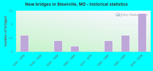
- New bridges - historical statistics
- 31930-1939
- 21950-1959
- 11960-1969
- 21980-1989
- 31990-1999
- 72000-2009


- Bridge Condition - Deck
- 54.5%Good
- 27.3%Satisfactory
- 18.2%Fair

- Bridge Condition - Superstructure
- 18.2%Excellent
- 27.3%Very good
- 27.3%Good
- 18.2%Satisfactory
- 9.1%Fair

- Bridge Condition - Substructure
- 18.2%Excellent
- 9.1%Very good
- 54.5%Good
- 9.1%Satisfactory
- 9.1%Fair

- Bridge Condition - Channel
- 11.8%Very good
- 35.3%Good
- 47.1%Satisfactory
- 5.9%Fair

- Bridge Condition - Culverts
- 42.9%Good
- 57.1%Satisfactory
Find on map >> Show street view
Structure Number: 11859, Location: S 28 T 38 N R 4 W (Lat: 37.989053, Lng: -91.376208), Route carried "on" structure: State highway 19, Year Built: 2000, Status: Open, Structure Length: 22.65m (74.31ft), Average Daily Traffic: 7,431 (year 2021), Truck Traffic: 16%, Average Future Daily Traffic: 11,147 (year 2041), Design Load: HS 20, Features Intersected: MERAMEC RVR
Minimum Vertical Clearance: 30+ m (98+ ft), Kilometerpoint: 207.620, Lanes on structure: 2, Base Highway Network: Yes, Owner: State Highway Agency, Approaching Roadway Width: 13.4m (44.0ft), Skew: 1 degrees, Material/Design: Prestressed concrete continuous, Design/Construction: Tee Beam, Number Of Spans In Main Unit: 7, Length of Maximum Span: 36.6m (120.1ft), Curb-To-Curb Width: 11.8m (38.7ft), Out-to-Out Width: 12.6m (41.3ft)
Condition: Deck: Good, Superstructure: Excellent, Substructure: Good, Channel: Satisfactory, Operating Rating: 67.5 metric tons, Method Used To Determine Operating Rating: Load Factor (LF), Inventory Rating: 28.8 metric tons, Method Used To Determine Inventory Rating: Load Factor (LF), Structural Evaluation: Better than present minimum criteria, Deck Geometry: Somewhat better than minimum adequacy, Waterway Adequacy: Superior to present desirable criteria, Approach Roadway Alignment: Equal to present desirable criteria, Designated Inspection Frequency: Every 24 months, Inspection Date: September 2020, Deck Structure Type: Concrete Cast-file-Place, Wearing Surface/Protective System: Wearing Surface: Monolithic Concrete, Deck Protection: Epoxy Coated Reinforcing
Find on map >> Show street view
Structure Number: 1186, Location: S 29 T 38 N R 4 W (Lat: 37.985033, Lng: -91.376864), Route carried "on" structure: State highway 19, Year Built: 2000, Status: Open, Structure Length: 0.95m (3.12ft), Average Daily Traffic: 7,431 (year 2021), Truck Traffic: 16%, Average Future Daily Traffic: 11,147 (year 2041), Design Load: HS 20, Features Intersected: MERAMEC RVR TRIB
Minimum Vertical Clearance: 30+ m (98+ ft), Kilometerpoint: 208.182, Lanes on structure: 2, Base Highway Network: Yes, Owner: State Highway Agency, Approaching Roadway Width: 12.2m (40.0ft), Skew: 3 degrees, Material/Design: Concrete continuous, Design/Construction: Culvert, Number Of Spans In Main Unit: 2, Length of Maximum Span: 3.7m (12.1ft)
Condition: Channel: Very good, Culverts: Satisfactory, Operating Rating: 87.3 metric tons, Method Used To Determine Operating Rating: Field evaluation and documented engineering judgment, Inventory Rating: 52.2 metric tons, Method Used To Determine Inventory Rating: Field evaluation and documented engineering judgment, Structural Evaluation: Equal to present minimum criteria, Waterway Adequacy: Superior to present desirable criteria, Approach Roadway Alignment: Equal to present desirable criteria, Designated Inspection Frequency: Every 24 months, Inspection Date: September 2020
Find on map >> Show street view
Structure Number: 11896, Location: S 29 T 38 N R 4 W (Lat: 37.984192, Lng: -91.377869), Route carried "on" structure: County highway , Year Built: 2000, Status: Open, Structure Length: 0.76m (2.49ft), Average Daily Traffic: 482 (year 2021), Truck Traffic: 10%, Average Future Daily Traffic: 675 (year 2041), Design Load: HS 20, Features Intersected: MERAMEC TRIB, Facility Carried by Structure: MCCORMICK RD E
Minimum Vertical Clearance: 30+ m (98+ ft), Kilometerpoint: 0.877, Lanes on structure: 2, Owner: State Highway Agency, Approaching Roadway Width: 7.3m (24.0ft), Material/Design: Concrete continuous, Design/Construction: Culvert, Number Of Spans In Main Unit: 2, Length of Maximum Span: 3.7m (12.1ft)
Condition: Channel: Very good, Culverts: Satisfactory, Inventory Rating: 61.2 metric tons, Method Used To Determine Inventory Rating: Load Factor (LF), Structural Evaluation: Equal to present minimum criteria, Waterway Adequacy: Superior to present desirable criteria, Approach Roadway Alignment: Equal to present desirable criteria, Designated Inspection Frequency: Every 24 months, Inspection Date: September 2020
Find on map >> Show street view
Structure Number: 23498, Location: S 33 T 38 N R 4 W (Lat: 37.966289, Lng: -91.359733), Route carried "on" structure: City street , Year Built: 1937, Status: Posted for load, Structure Length: 2.77m (9.09ft), Average Daily Traffic: 35 (year 2021), Truck Traffic: 10%, Average Future Daily Traffic: 46 (year 2041), Features Intersected: YADKIN CR, Facility Carried by Structure: SPRING ST
Minimum Vertical Clearance: 30+ m (98+ ft), Kilometerpoint: 0.161, Lanes on structure: 1, Owner: City or Municipal Highway Agency, Approaching Roadway Width: 4.6m (15.1ft), Material/Design: Steel, Design/Construction: Stringer/Multi-beam, Number Of Spans In Main Unit: 3, Length of Maximum Span: 8.8m (28.9ft), Curb-To-Curb Width: 4.3m (14.1ft), Out-to-Out Width: 5.1m (16.7ft)
Condition: Deck: Fair, Superstructure: Fair, Substructure: Fair, Channel: Satisfactory, Operating Rating: 40.5 metric tons, Method Used To Determine Operating Rating: Allowable Stress (AS), Inventory Rating: 20.7 metric tons, Method Used To Determine Inventory Rating: Allowable Stress (AS), Structural Evaluation: Somewhat better than minimum adequacy, Deck Geometry: Equal to present minimum criteria, Waterway Adequacy: Better than present minimum criteria, Approach Roadway Alignment: Equal to present desirable criteria, Designated Inspection Frequency: Every 24 months, Inspection Date: Febuary 2021, Deck Structure Type: Concrete Cast-file-Place, Wearing Surface/Protective System: Wearing Surface: Bituminous
Find on map >> Show street view
Structure Number: 29019, Location: S 7 T 37 N R 4 W (Lat: 37.944903, Lng: -91.415775), Route carried "on" structure: State highway M, Year Built: 2002, Status: Open, Structure Length: 1.08m (3.54ft), Average Daily Traffic: 409 (year 2021), Truck Traffic: 11%, Average Future Daily Traffic: 573 (year 2041), Design Load: HS 20, Features Intersected: PERKINS BR
Minimum Vertical Clearance: 30+ m (98+ ft), Kilometerpoint: 2.166, Lanes on structure: 2, Owner: State Highway Agency, Approaching Roadway Width: 7.3m (24.0ft), Skew: 1 degrees, Material/Design: Concrete continuous, Design/Construction: Culvert, Number Of Spans In Main Unit: 3, Length of Maximum Span: 3.7m (12.1ft)
Condition: Channel: Good, Culverts: Good, Inventory Rating: 71.1 metric tons, Method Used To Determine Inventory Rating: Load Factor (LF), Structural Evaluation: Better than present minimum criteria, Waterway Adequacy: Superior to present desirable criteria, Approach Roadway Alignment: Equal to present desirable criteria, Designated Inspection Frequency: Every 24 months, Inspection Date: September 2020
Find on map >> Show street view
Structure Number: 29738, Location: S 34 T 38 N R 4 W (Lat: 37.967439, Lng: -91.354525), Route carried "on" structure: City street 4105, Year Built: 2001, Status: Open, Structure Length: 1.30m (4.27ft), Average Daily Traffic: 125 (year 2021), Truck Traffic: 10%, Average Future Daily Traffic: 150 (year 2041), Features Intersected: YADKIN CR, Facility Carried by Structure: 1ST ST
Minimum Vertical Clearance: 30+ m (98+ ft), Kilometerpoint: 0.000, Lanes on structure: 2, Owner: City or Municipal Highway Agency, Approaching Roadway Width: 7.9m (25.9ft), Skew: 1 degrees, Material/Design: Steel, Design/Construction: Stringer/Multi-beam, Number Of Spans In Main Unit: 1, Length of Maximum Span: 12.0m (39.4ft), Curb-To-Curb Width: 7.3m (24.0ft), Out-to-Out Width: 9.1m (29.9ft)
Condition: Deck: Good, Superstructure: Very good, Substructure: Good, Channel: Satisfactory, Operating Rating: 37.8 metric tons, Method Used To Determine Operating Rating: Load Factor (LF), Inventory Rating: 22.5 metric tons, Method Used To Determine Inventory Rating: Load Factor (LF), Structural Evaluation: Equal to present minimum criteria, Deck Geometry: Somewhat better than minimum adequacy, Waterway Adequacy: Better than present minimum criteria, Approach Roadway Alignment: Equal to present desirable criteria, Designated Inspection Frequency: Every 24 months, Inspection Date: Febuary 2021, Deck Structure Type: Concrete Cast-file-Place
Find on map >> Show street view
Structure Number: 31175, Location: S 33 T 38 N R 4 W (Lat: 37.966447, Lng: -91.358231), Route carried "on" structure: City street 410, Year Built: 2003, Status: Open, Structure Length: 1.28m (4.20ft), Average Daily Traffic: 120 (year 2021), Truck Traffic: 5%, Average Future Daily Traffic: 144 (year 2041), Design Load: HS 20, Features Intersected: YADKIN CR, Facility Carried by Structure: 4TH ST
Minimum Vertical Clearance: 30+ m (98+ ft), Kilometerpoint: 0.322, Lanes on structure: 2, Owner: City or Municipal Highway Agency, Approaching Roadway Width: 5.8m (19.0ft), Material/Design: Steel, Design/Construction: Stringer/Multi-beam, Number Of Spans In Main Unit: 1, Length of Maximum Span: 11.9m (39.0ft), Curb-To-Curb Width: 8.8m (28.9ft), Out-to-Out Width: 12.8m (42.0ft)
Condition: Deck: Good, Superstructure: Excellent, Substructure: Good, Channel: Satisfactory, Operating Rating: 33.3 metric tons, Method Used To Determine Operating Rating: Load Factor (LF), Inventory Rating: 19.8 metric tons, Method Used To Determine Inventory Rating: Load Factor (LF), Structural Evaluation: Somewhat better than minimum adequacy, Deck Geometry: Equal to present minimum criteria, Waterway Adequacy: Better than present minimum criteria, Approach Roadway Alignment: Equal to present desirable criteria, Designated Inspection Frequency: Every 24 months, Inspection Date: Febuary 2021, Deck Structure Type: Concrete Cast-file-Place
Find on map >> Show street view
Structure Number: 31176, Location: S 33 T 38 N R 4 W (Lat: 37.967194, Lng: -91.355100), Route carried "on" structure: City street 410, Year Built: 2003, Status: Posted for load, Structure Length: 1.19m (3.90ft), Average Daily Traffic: 100 (year 2021), Truck Traffic: 5%, Average Future Daily Traffic: 120 (year 2041), Design Load: HS 20, Features Intersected: YADKIN CR, Facility Carried by Structure: 3RD STREET
Minimum Vertical Clearance: 30+ m (98+ ft), Kilometerpoint: 0.322, Lanes on structure: 1, Owner: City or Municipal Highway Agency, Approaching Roadway Width: 4.6m (15.1ft), Material/Design: Concrete continuous, Design/Construction: Slab, Number Of Spans In Main Unit: 3, Length of Maximum Span: 3.7m (12.1ft), Curb or Sidewalk Widths: Left: 1.2m (3.9ft), Right: 0.0m, Curb-To-Curb Width: 4.9m (16.1ft), Out-to-Out Width: 7.3m (24.0ft)
Condition: Deck: Satisfactory, Superstructure: Satisfactory, Substructure: Satisfactory, Channel: Satisfactory, Operating Rating: 80.1 metric tons, Method Used To Determine Operating Rating: Load Factor (LF), Inventory Rating: 48.6 metric tons, Method Used To Determine Inventory Rating: Load Factor (LF), Structural Evaluation: Equal to present minimum criteria, Deck Geometry: High priority of corrective action, Waterway Adequacy: Meets minimum limits, Approach Roadway Alignment: Equal to present minimum criteria, Designated Inspection Frequency: Every 24 months, Inspection Date: Febuary 2021, Deck Structure Type: Concrete Cast-file-Place, Wearing Surface/Protective System: Wearing Surface: Bituminous
Find on map >> Show street view
Structure Number: 3689, Location: S 34 T 38 N R 4 W (Lat: 37.968681, Lng: -91.352478), Route carried "on" structure: State highway 8, Year Built: 1989, Status: Open, Structure Length: 5.27m (17.29ft), Average Daily Traffic: 6,547 (year 2021), Truck Traffic: 11%, Average Future Daily Traffic: 12,439 (year 2041), Design Load: HS 20, Features Intersected: YADKIN CR
Minimum Vertical Clearance: 30+ m (98+ ft), Kilometerpoint: 29.140, Lanes on structure: 2, Base Highway Network: Yes, Owner: State Highway Agency, Approaching Roadway Width: 15.5m (50.9ft), Skew: 4 degrees, Material/Design: Prestressed concrete continuous, Design/Construction: Stringer/Multi-beam, Number Of Spans In Main Unit: 3, Length of Maximum Span: 17.9m (58.7ft), Curb or Sidewalk Widths: Left: 0.2m (0.7ft), Right: 0.2m (0.7ft), Curb-To-Curb Width: 13.0m (42.7ft), Out-to-Out Width: 13.9m (45.6ft)
Condition: Deck: Satisfactory, Superstructure: Very good, Substructure: Good, Channel: Satisfactory, Operating Rating: 58.5 metric tons, Method Used To Determine Operating Rating: Load Factor (LF), Inventory Rating: 34.2 metric tons, Method Used To Determine Inventory Rating: Load Factor (LF), Structural Evaluation: Better than present minimum criteria, Deck Geometry: Somewhat better than minimum adequacy, Waterway Adequacy: Equal to present desirable criteria, Approach Roadway Alignment: Equal to present minimum criteria, Designated Inspection Frequency: Every 24 months, Inspection Date: September 2020, Deck Structure Type: Concrete Cast-file-Place, Wearing Surface/Protective System: Wearing Surface: Bituminous, Deck Protection: Epoxy Coated Reinforcing
Find on map >> Show street view
Structure Number: 369, Location: S 19 T 27 N R 32 W (Lat: 37.049497, Lng: -94.462014), Route carried "on" structure: Interstate 44, Year Built: 1960, Year Reconstructed: 1994, Status: Open, Structure Length: 5.00m (16.40ft), Average Daily Traffic: 23,439 (year 2021), Truck Traffic: 28%, Average Future Daily Traffic: 43,362 (year 2041), Design Load: HS 20, Features Intersected: KCS RR
Minimum Vertical Clearance: 30+ m (98+ ft), Kilometerpoint: 15.690, Lanes on structure: 2, Base Highway Network: Yes, Owner: State Highway Agency, Approaching Roadway Width: 12.2m (40.0ft), Skew: 2 degrees, Material/Design: Steel continuous, Design/Construction: Stringer/Multi-beam, Number Of Spans In Main Unit: 3, Length of Maximum Span: 18.3m (60.0ft), Curb or Sidewalk Widths: Left: 0.2m (0.7ft), Right: 0.2m (0.7ft), Curb-To-Curb Width: 11.2m (36.7ft), Out-to-Out Width: 12.0m (39.4ft)
Condition: Deck: Fair, Superstructure: Good, Substructure: Good, Operating Rating: 54.9 metric tons, Method Used To Determine Operating Rating: Load Factor (LF), Inventory Rating: 32.4 metric tons, Method Used To Determine Inventory Rating: Load Factor (LF), Structural Evaluation: Better than present minimum criteria, Deck Geometry: Somewhat better than minimum adequacy, Underclear: Somewhat better than minimum adequacy, Approach Roadway Alignment: Equal to present desirable criteria, Designated Inspection Frequency: Every 24 months, Inspection Date: September 2021, Deck Structure Type: Concrete Cast-file-Place, Wearing Surface/Protective System: Wearing Surface: Low Slump Concrete
Find on map >> Show street view
Structure Number: 369, Location: S 34 T 38 N R 4 W (Lat: 37.967928, Lng: -91.353778), Route carried "on" structure: State highway 19, Year Built: 1989, Status: Open, Structure Length: 4.15m (13.62ft), Average Daily Traffic: 4,726 (year 2021), Truck Traffic: 16%, Average Future Daily Traffic: 7,089 (year 2041), Design Load: HS 20, Features Intersected: YADKIN CR
Minimum Vertical Clearance: 30+ m (98+ ft), Kilometerpoint: 211.528, Lanes on structure: 2, Base Highway Network: Yes, Owner: State Highway Agency, Approaching Roadway Width: 11.9m (39.0ft), Skew: 2 degrees, Material/Design: Prestressed concrete continuous, Design/Construction: Tee Beam, Number Of Spans In Main Unit: 3, Length of Maximum Span: 13.9m (45.6ft), Curb or Sidewalk Widths: Left: 0.2m (0.7ft), Right: 0.2m (0.7ft), Curb-To-Curb Width: 11.8m (38.7ft), Out-to-Out Width: 12.6m (41.3ft)
Condition: Deck: Satisfactory, Superstructure: Satisfactory, Substructure: Very good, Channel: Good, Operating Rating: 71.1 metric tons, Method Used To Determine Operating Rating: Load Factor (LF), Inventory Rating: 43.2 metric tons, Method Used To Determine Inventory Rating: Load Factor (LF), Structural Evaluation: Equal to present minimum criteria, Deck Geometry: Somewhat better than minimum adequacy, Waterway Adequacy: Equal to present desirable criteria, Approach Roadway Alignment: Equal to present desirable criteria, Designated Inspection Frequency: Every 24 months, Inspection Date: September 2020, Deck Structure Type: Concrete Cast-file-Place, Wearing Surface/Protective System: Wearing Surface: Bituminous, Deck Protection: Epoxy Coated Reinforcing
Find on map >> Show street view
Structure Number: 3822, Location: S 22 T 61 N R 24 W (Lat: 40.075622, Lng: -93.589422), Route carried "on" structure: State highway 6, Year Built: 1990, Status: Open, Structure Length: 6.16m (20.21ft), Average Daily Traffic: 4,383 (year 2021), Truck Traffic: 9%, Average Future Daily Traffic: 5,698 (year 2041), Design Load: HS 20, Features Intersected: MUDDY CR
Minimum Vertical Clearance: 30+ m (98+ ft), Kilometerpoint: 127.436, Lanes on structure: 2, Base Highway Network: Yes, Owner: State Highway Agency, Approaching Roadway Width: 17.1m (56.1ft), Material/Design: Prestressed concrete continuous, Design/Construction: Stringer/Multi-beam, Number Of Spans In Main Unit: 3, Length of Maximum Span: 20.6m (67.6ft), Curb or Sidewalk Widths: Left: 0.2m (0.7ft), Right: 0.2m (0.7ft), Curb-To-Curb Width: 16.7m (54.8ft), Out-to-Out Width: 17.5m (57.4ft)
Condition: Deck: Good, Superstructure: Very good, Substructure: Excellent, Channel: Good, Operating Rating: 72.0 metric tons, Method Used To Determine Operating Rating: Load Factor (LF), Inventory Rating: 36.0 metric tons, Method Used To Determine Inventory Rating: Load Factor (LF), Structural Evaluation: Equal to present desirable criteria, Deck Geometry: Superior to present desirable criteria, Waterway Adequacy: Superior to present desirable criteria, Approach Roadway Alignment: Equal to present desirable criteria, Designated Inspection Frequency: Every 24 months, Inspection Date: October 2021, Deck Structure Type: Concrete Cast-file-Place, Wearing Surface/Protective System: Wearing Surface: Monolithic Concrete, Deck Protection: Epoxy Coated Reinforcing
Find on map >> Show street view
Structure Number: 3878, Location: S 35 T 38 N R 4 W (Lat: 37.972497, Lng: -91.339100), Route carried "on" structure: State highway 8, Year Built: 1992, Status: Open, Structure Length: 5.52m (18.11ft), Average Daily Traffic: 6,547 (year 2021), Truck Traffic: 11%, Average Future Daily Traffic: 12,439 (year 2041), Design Load: HS 20+Mod, Features Intersected: WHITTENBURG CR
Minimum Vertical Clearance: 30+ m (98+ ft), Kilometerpoint: 30.470, Lanes on structure: 2, Base Highway Network: Yes, Owner: State Highway Agency, Approaching Roadway Width: 13.4m (44.0ft), Material/Design: Prestressed concrete continuous, Design/Construction: Stringer/Multi-beam, Number Of Spans In Main Unit: 3, Length of Maximum Span: 18.5m (60.7ft), Curb or Sidewalk Widths: Left: 0.2m (0.7ft), Right: 0.2m (0.7ft), Curb-To-Curb Width: 13.0m (42.7ft), Out-to-Out Width: 13.9m (45.6ft)
Condition: Deck: Good, Superstructure: Good, Substructure: Excellent, Channel: Good, Operating Rating: 67.5 metric tons, Method Used To Determine Operating Rating: Load Factor (LF), Inventory Rating: 38.7 metric tons, Method Used To Determine Inventory Rating: Load Factor (LF), Structural Evaluation: Better than present minimum criteria, Deck Geometry: Somewhat better than minimum adequacy, Waterway Adequacy: Equal to present desirable criteria, Approach Roadway Alignment: Equal to present desirable criteria, Designated Inspection Frequency: Every 24 months, Inspection Date: September 2020, Deck Structure Type: Concrete Cast-file-Place, Wearing Surface/Protective System: Wearing Surface: Monolithic Concrete, Deck Protection: Epoxy Coated Reinforcing
Find on map >> Show street view
Structure Number: 4305, Location: S 11 T 37 N R 4 W (Lat: 37.940239, Lng: -91.332503), Route carried "on" structure: State highway 19, Year Built: 1995, Status: Open, Structure Length: 3.08m (10.10ft), Average Daily Traffic: 5,697 (year 2021), Truck Traffic: 16%, Average Future Daily Traffic: 8,546 (year 2041), Design Load: HS 20, Features Intersected: WHITTENBURG CR
Minimum Vertical Clearance: 30+ m (98+ ft), Kilometerpoint: 215.352, Lanes on structure: 2, Base Highway Network: Yes, Owner: State Highway Agency, Approaching Roadway Width: 11.9m (39.0ft), Material/Design: Prestressed concrete continuous, Design/Construction: Stringer/Multi-beam, Number Of Spans In Main Unit: 2, Length of Maximum Span: 15.4m (50.5ft), Curb or Sidewalk Widths: Left: 0.2m (0.7ft), Right: 0.2m (0.7ft), Curb-To-Curb Width: 11.8m (38.7ft), Out-to-Out Width: 12.6m (41.3ft)
Condition: Deck: Good, Superstructure: Good, Substructure: Good, Channel: Good, Operating Rating: 85.5 metric tons, Method Used To Determine Operating Rating: Load Factor (LF), Inventory Rating: 50.4 metric tons, Method Used To Determine Inventory Rating: Load Factor (LF), Structural Evaluation: Better than present minimum criteria, Deck Geometry: Somewhat better than minimum adequacy, Waterway Adequacy: Equal to present desirable criteria, Approach Roadway Alignment: Equal to present desirable criteria, Designated Inspection Frequency: Every 24 months, Inspection Date: September 2020, Deck Structure Type: Concrete Cast-file-Place, Wearing Surface/Protective System: Wearing Surface: Monolithic Concrete, Deck Protection: Epoxy Coated Reinforcing
Find on map >> Show street view
Structure Number: 5407, Location: S 36 T 33 N R 4 E (Lat: 37.599264, Lng: -90.537833), Route carried "on" structure: State highway 72, Year Built: 1930, Status: Open, Structure Length: 0.73m (2.40ft), Average Daily Traffic: 1,662 (year 2021), Truck Traffic: 22%, Average Future Daily Traffic: 2,493 (year 2041), Design Load: H 15, Features Intersected: BR OF STOUTS CR
Minimum Vertical Clearance: 30+ m (98+ ft), Kilometerpoint: 177.683, Lanes on structure: 2, Base Highway Network: Yes, Owner: State Highway Agency, Approaching Roadway Width: 9.8m (32.2ft), Skew: 4 degrees, Material/Design: Concrete continuous, Design/Construction: Culvert, Number Of Spans In Main Unit: 2, Length of Maximum Span: 2.4m (7.9ft), Curb-To-Curb Width: 9.8m (32.2ft), Out-to-Out Width: 10.4m (34.1ft)
Condition: Channel: Satisfactory, Culverts: Good, Operating Rating: 70.2 metric tons, Method Used To Determine Operating Rating: Load Factor (LF), Inventory Rating: 42.3 metric tons, Method Used To Determine Inventory Rating: Load Factor (LF), Structural Evaluation: Better than present minimum criteria, Deck Geometry: Somewhat better than minimum adequacy, Waterway Adequacy: Equal to present minimum criteria, Approach Roadway Alignment: Equal to present minimum criteria, Designated Inspection Frequency: Every 24 months, Inspection Date: October 2021
Find on map >> Show street view
Structure Number: 5737, Location: S 1 T 39 N R 4 W (Lat: 37.963150, Lng: -91.351844), Route carried "on" structure: State highway 19, Year Built: 1934, Status: Open, Structure Length: 1.04m (3.41ft), Average Daily Traffic: 5,697 (year 2021), Truck Traffic: 16%, Average Future Daily Traffic: 8,546 (year 2041), Design Load: H 15, Features Intersected: DRY BR YADKIN CR
Minimum Vertical Clearance: 30+ m (98+ ft), Kilometerpoint: 212.096, Lanes on structure: 2, Base Highway Network: Yes, Owner: State Highway Agency, Approaching Roadway Width: 9.1m (29.9ft), Skew: 1 degrees, Material/Design: Concrete continuous, Design/Construction: Culvert, Number Of Spans In Main Unit: 4, Length of Maximum Span: 2.4m (7.9ft), Curb-To-Curb Width: 10.5m (34.4ft), Out-to-Out Width: 11.1m (36.4ft)
Condition: Channel: Good, Culverts: Good, Operating Rating: 64.8 metric tons, Method Used To Determine Operating Rating: Load Factor (LF), Inventory Rating: 38.7 metric tons, Method Used To Determine Inventory Rating: Load Factor (LF), Structural Evaluation: Better than present minimum criteria, Deck Geometry: Meets minimum limits, Waterway Adequacy: Equal to present desirable criteria, Approach Roadway Alignment: Equal to present minimum criteria, Designated Inspection Frequency: Every 24 months, Inspection Date: September 2020
Find on map >> Show street view
Structure Number: 6965, Location: S 13 T 38 N R 4 W (Lat: 38.015319, Lng: -91.319233), Route carried "on" structure: State highway TT, Year Built: 1957, Status: Open, Structure Length: 1.18m (3.87ft), Average Daily Traffic: 320 (year 2021), Truck Traffic: 7%, Average Future Daily Traffic: 448 (year 2041), Design Load: H 10, Features Intersected: WALKER CR
Minimum Vertical Clearance: 30+ m (98+ ft), Kilometerpoint: 3.262, Lanes on structure: 2, Owner: State Highway Agency, Approaching Roadway Width: 7.3m (24.0ft), Skew: 1 degrees, Material/Design: Concrete continuous, Design/Construction: Culvert, Number Of Spans In Main Unit: 3, Length of Maximum Span: 3.7m (12.1ft), Curb-To-Curb Width: 11.5m (37.7ft), Out-to-Out Width: 12.1m (39.7ft)
Condition: Channel: Satisfactory, Culverts: Satisfactory, Operating Rating: 53.1 metric tons, Method Used To Determine Operating Rating: Load Factor (LF), Inventory Rating: 31.5 metric tons, Method Used To Determine Inventory Rating: Load Factor (LF), Structural Evaluation: Equal to present minimum criteria, Deck Geometry: Superior to present desirable criteria, Waterway Adequacy: Equal to present desirable criteria, Approach Roadway Alignment: Equal to present minimum criteria, Designated Inspection Frequency: Every 24 months, Inspection Date: September 2020
Find on map >> Show street view
Structure Number: 7003, Location: S 13 T 38 N R 4 W (Lat: 38.012531, Lng: -91.319681), Route carried "on" structure: State highway TT, Year Built: 1957, Status: Open, Structure Length: 0.88m (2.89ft), Average Daily Traffic: 320 (year 2021), Truck Traffic: 7%, Average Future Daily Traffic: 448 (year 2041), Design Load: H 10, Features Intersected: DRAIN DTCH
Minimum Vertical Clearance: 30+ m (98+ ft), Kilometerpoint: 3.576, Lanes on structure: 2, Owner: State Highway Agency, Approaching Roadway Width: 7.3m (24.0ft), Skew: 4 degrees, Material/Design: Concrete continuous, Design/Construction: Culvert, Number Of Spans In Main Unit: 2, Length of Maximum Span: 3.0m (9.8ft), Curb-To-Curb Width: 7.3m (24.0ft), Out-to-Out Width: 7.9m (25.9ft)
Condition: Channel: Fair, Culverts: Satisfactory, Operating Rating: 39.6 metric tons, Method Used To Determine Operating Rating: Load Factor (LF), Inventory Rating: 23.4 metric tons, Method Used To Determine Inventory Rating: Load Factor (LF), Structural Evaluation: Equal to present minimum criteria, Deck Geometry: Somewhat better than minimum adequacy, Waterway Adequacy: Equal to present desirable criteria, Approach Roadway Alignment: Equal to present minimum criteria, Designated Inspection Frequency: Every 24 months, Inspection Date: September 2020