Bridge Statistics for Stem, North Carolina (NC)
Condition, Traffic, Stress, Structural Evaluation, Project Costs
- National Bridge Inventory (NBI) Statistics
- 12Number of bridges
- 105ft / 32.4mTotal length
- 74,110Total average daily traffic
- 15,536Total average daily truck traffic
- National Bridge Inventory (NBI) Registered Bridges for Stem
- No street view available for this location
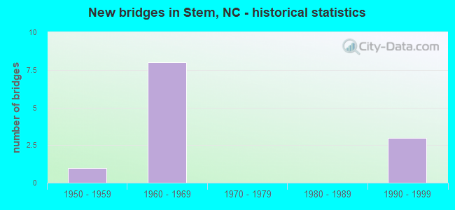
- New bridges - historical statistics
- 11950-1959
- 81960-1969
- 31990-1999


- Bridge Condition - Deck
- 50.0%Good
- 50.0%Satisfactory

- Bridge Condition - Superstructure
- 50.0%Satisfactory
- 50.0%Fair

- Bridge Condition - Substructure
- 25.0%Good
- 75.0%Satisfactory

- Bridge Condition - Channel
- 40.0%Good
- 20.0%Satisfactory
- 40.0%Fair

- Bridge Condition - Culverts
- 25.0%Good
- 50.0%Satisfactory
- 25.0%Fair
Find on map >> Show street view
Structure Number: 770051, Location: 2.7 MI.N. SR1127 (Lat: 36.203636, Lng: -78.679114), Route carried "on" structure: Interstate 85, Year Built: 1969, Status: Open, Structure Length: 4.14m (13.58ft), Average Daily Traffic: 16,000 (year 2013), Truck Traffic: 23%, Average Future Daily Traffic: 32,000 (year 2040), Design Load: HS 20+Mod, Features Intersected: SR1132
Minimum Vertical Clearance: 30+ m (98+ ft), Kilometerpoint: 59.619, Lanes on structure: 2, Lanes under structure: 2, Base Highway Network: Yes (Inventory Route: 1, Subroute: 85), Owner: State Highway Agency, Approaching Roadway Width: 12.8m (42.0ft), Skew: 10 degrees, Material/Design: Prestressed concrete, Design/Construction: Stringer/Multi-beam, Number Of Spans In Main Unit: 3, Length of Maximum Span: 13.4m (44.0ft), Curb-To-Curb Width: 11.9m (39.0ft), Out-to-Out Width: 12.8m (42.0ft)
Condition: Deck: Good, Superstructure: Satisfactory, Substructure: Good, Operating Rating: 89.8 metric tons, Method Used To Determine Operating Rating: Load Factor (LF), Inventory Rating: 46.2 metric tons, Method Used To Determine Inventory Rating: Load Factor (LF), Structural Evaluation: Equal to present minimum criteria, Deck Geometry: Equal to present minimum criteria, Underclear: Equal to present minimum criteria, Approach Roadway Alignment: Equal to present desirable criteria, Designated Inspection Frequency: Every 24 months, Inspection Date: June 2020, Deck Structure Type: Concrete Cast-file-Place, Wearing Surface/Protective System: Wearing Surface: Monolithic Concrete
Find on map >> Show street view
Structure Number: 770052, Location: 2.7 MI.N.SR1127 (Lat: 36.203767, Lng: -78.679383), Route carried "on" structure: Interstate 85, Year Built: 1969, Status: Open, Structure Length: 4.14m (13.58ft), Average Daily Traffic: 17,000 (year 2018), Truck Traffic: 23%, Average Future Daily Traffic: 34,000 (year 2040), Design Load: HS 20+Mod, Features Intersected: SR1132
Minimum Vertical Clearance: 30+ m (98+ ft), Kilometerpoint: 59.619, Lanes on structure: 2, Lanes under structure: 2, Base Highway Network: Yes (Inventory Route: 1, Subroute: 85), Owner: State Highway Agency, Approaching Roadway Width: 11.8m (38.7ft), Skew: 10 degrees, Material/Design: Prestressed concrete, Design/Construction: Stringer/Multi-beam, Number Of Spans In Main Unit: 3, Length of Maximum Span: 13.4m (44.0ft), Curb-To-Curb Width: 12.1m (39.7ft), Out-to-Out Width: 12.8m (42.0ft)
Condition: Deck: Good, Superstructure: Satisfactory, Substructure: Satisfactory, Operating Rating: 84.3 metric tons, Method Used To Determine Operating Rating: Load Factor (LF), Inventory Rating: 43.5 metric tons, Method Used To Determine Inventory Rating: Load Factor (LF), Structural Evaluation: Equal to present minimum criteria, Deck Geometry: Equal to present minimum criteria, Underclear: Somewhat better than minimum adequacy, Approach Roadway Alignment: Equal to present desirable criteria, Designated Inspection Frequency: Every 24 months, Inspection Date: June 2020, Deck Structure Type: Concrete Cast-file-Place, Wearing Surface/Protective System: Wearing Surface: Monolithic Concrete, Deck Protection: Epoxy Coated Reinforcing
Find on map >> Show street view
Structure Number: 770054, Location: 0.6 MI.E. OF SR1133 (Lat: 36.218900, Lng: -78.662714), Route carried "on" structure: State highway 1135, Year Built: 1969, Status: Open, Structure Length: 10.94m (35.89ft), Average Daily Traffic: 540 (year 2013), Truck Traffic: 6%, Average Future Daily Traffic: 1,080 (year 2040), Design Load: H 15, Features Intersected: I85
Minimum Vertical Clearance: 30+ m (98+ ft), Kilometerpoint: 0.000, Lanes on structure: 2, Lanes under structure: 4, Owner: State Highway Agency, Approaching Roadway Width: 6.0m (19.7ft), Skew: 4 degrees, Material/Design: Steel, Design/Construction: Stringer/Multi-beam, Number Of Spans In Main Unit: 4, Length of Maximum Span: 32.6m (107.0ft), Curb-To-Curb Width: 8.9m (29.2ft), Out-to-Out Width: 9.7m (31.8ft)
Condition: Deck: Satisfactory, Superstructure: Fair, Substructure: Satisfactory, Operating Rating: 51.7 metric tons, Method Used To Determine Operating Rating: Load Factor (LF), Inventory Rating: 30.8 metric tons, Method Used To Determine Inventory Rating: Load Factor (LF), Structural Evaluation: Somewhat better than minimum adequacy, Deck Geometry: Somewhat better than minimum adequacy, Underclear: Meets minimum limits, Approach Roadway Alignment: Equal to present desirable criteria, Designated Inspection Frequency: Every 24 months, Inspection Date: July 2020, Deck Structure Type: Concrete Cast-file-Place, Wearing Surface/Protective System: Wearing Surface: Latex Concrete
Find on map >> Show street view
Structure Number: 770077, Location: 0.3 MI.N. OF JCT.SR1127 (Lat: 36.183411, Lng: -78.710775), Route carried "on" structure: State highway 1131, Year Built: 1990, Status: Open, Structure Length: 0.76m (2.49ft), Average Daily Traffic: 810 (year 2015), Truck Traffic: 6%, Average Future Daily Traffic: 1,620 (year 2040), Design Load: HS 20+Mod, Features Intersected: HOLMAN CREEK
Minimum Vertical Clearance: 30+ m (98+ ft), Kilometerpoint: 0.000, Lanes on structure: 2, Owner: State Highway Agency, Approaching Roadway Width: 6.0m (19.7ft), Material/Design: Steel, Design/Construction: Culvert, Number Of Spans In Main Unit: 2, Length of Maximum Span: 3.3m (10.8ft)
Condition: Channel: Fair, Culverts: Satisfactory, Operating Rating: 89.8 metric tons, Method Used To Determine Operating Rating: Load and Resistance Factor (LRFR), Inventory Rating: 89.8 metric tons, Method Used To Determine Inventory Rating: Load and Resistance Factor (LRFR), Structural Evaluation: Equal to present minimum criteria, Waterway Adequacy: Better than present minimum criteria, Approach Roadway Alignment: Equal to present desirable criteria, Designated Inspection Frequency: Every 24 months, Underwater Inspection Frequency: Every 60 months, Inspection Date: August 2020, Underwater Inspection Date: August 2020
Find on map >> Show street view
Structure Number: 770208, Location: 0.2 MI.S.JCT.SR1139 (Lat: 36.255981, Lng: -78.738992), Route carried "on" structure: State highway 1126, Year Built: 1998, Status: Open, Structure Length: 0.64m (2.10ft), Average Daily Traffic: 1,600 (year 2013), Truck Traffic: 6%, Average Future Daily Traffic: 3,200 (year 2040), Design Load: HS 20+Mod, Features Intersected: ROCKY CREEK
Minimum Vertical Clearance: 30+ m (98+ ft), Kilometerpoint: 0.000, Lanes on structure: 2, Owner: State Highway Agency, Approaching Roadway Width: 7.0m (23.0ft), Material/Design: Steel, Design/Construction: Culvert, Number Of Spans In Main Unit: 2, Length of Maximum Span: 2.7m (8.9ft)
Condition: Channel: Fair, Culverts: Good, Operating Rating: 89.8 metric tons, Method Used To Determine Operating Rating: Load and Resistance Factor (LRFR), Inventory Rating: 89.8 metric tons, Method Used To Determine Inventory Rating: Load and Resistance Factor (LRFR), Structural Evaluation: Better than present minimum criteria, Waterway Adequacy: Better than present minimum criteria, Approach Roadway Alignment: Equal to present desirable criteria, Designated Inspection Frequency: Every 24 months, Inspection Date: September 2020
Find on map >> Show street view
Structure Number: 770244, Location: 2.4 MI. S. JCT. SR1126 (Lat: 36.187744, Lng: -78.772125), Route carried "on" structure: State highway 1123, Year Built: 1965, Status: Posted for load, Structure Length: 10.36m (33.99ft), Average Daily Traffic: 190 (year 2000), Truck Traffic: 6%, Average Future Daily Traffic: 380 (year 2040), Design Load: H 15, Features Intersected: KNAP OF REEDS CREEK
Minimum Vertical Clearance: 30+ m (98+ ft), Kilometerpoint: 0.000, Lanes on structure: 2, Owner: State Highway Agency, Approaching Roadway Width: 6.4m (21.0ft), Material/Design: Steel, Design/Construction: Stringer/Multi-beam, Number Of Spans In Main Unit: 6, Length of Maximum Span: 21.0m (68.9ft), Curb-To-Curb Width: 7.7m (25.3ft), Out-to-Out Width: 9.1m (29.9ft)
Condition: Deck: Satisfactory, Superstructure: Fair, Substructure: Satisfactory, Channel: Good, Operating Rating: 40.8 metric tons, Method Used To Determine Operating Rating: Load Factor (LF), Inventory Rating: 24.4 metric tons, Method Used To Determine Inventory Rating: Load Factor (LF), Structural Evaluation: Somewhat better than minimum adequacy, Deck Geometry: Somewhat better than minimum adequacy, Waterway Adequacy: Better than present minimum criteria, Approach Roadway Alignment: Equal to present desirable criteria, Bridge Posting: Required (Relationship of Operating Rating to Maximum Legal Load: 0.1 - 9.9% below), Designated Inspection Frequency: Every 24 months, Underwater Inspection Frequency: Every 60 months, Inspection Date: June 2020, Underwater Inspection Date: March 2020, Deck Structure Type: Concrete Cast-file-Place, Wearing Surface/Protective System: Wearing Surface: Monolithic Concrete
Find on map >> Show street view
Structure Number: 770252, Location: 0.4 MI.S.SR1153 (Lat: 36.239464, Lng: -78.696031), Route carried "on" structure: State highway 1004, Year Built: 1957, Status: Open, Structure Length: 0.76m (2.49ft), Average Daily Traffic: 2,500 (year 2018), Truck Traffic: 7%, Average Future Daily Traffic: 5,000 (year 2040), Design Load: HS 20+Mod, Features Intersected: JACKSON CREEK
Minimum Vertical Clearance: 30+ m (98+ ft), Kilometerpoint: 0.000, Lanes on structure: 2, Owner: State Highway Agency, Approaching Roadway Width: 6.7m (22.0ft), Material/Design: Concrete continuous, Design/Construction: Culvert, Number Of Spans In Main Unit: 3, Length of Maximum Span: 2.4m (7.9ft)
Condition: Channel: Satisfactory, Culverts: Satisfactory, Operating Rating: 41.7 metric tons, Method Used To Determine Operating Rating: Field evaluation and documented engineering judgment, Inventory Rating: 32.6 metric tons, Method Used To Determine Inventory Rating: Field evaluation and documented engineering judgment, Structural Evaluation: Equal to present minimum criteria, Waterway Adequacy: Better than present minimum criteria, Approach Roadway Alignment: Equal to present desirable criteria, Designated Inspection Frequency: Every 24 months, Inspection Date: August 2020
Find on map >> Show street view
Structure Number: 77026, Location: 0.3 MI S. JCT SR1139 (Lat: 36.257786, Lng: -78.727322), Route carried "on" structure: State highway 1138, Year Built: 1996, Status: Open, Structure Length: 0.70m (2.30ft), Average Daily Traffic: 1,700 (year 2017), Truck Traffic: 7%, Average Future Daily Traffic: 3,400 (year 2040), Design Load: HS 20+Mod, Features Intersected: ROCKY CREEK
Minimum Vertical Clearance: 30+ m (98+ ft), Kilometerpoint: 0.000, Lanes on structure: 2, Owner: State Highway Agency, Approaching Roadway Width: 6.0m (19.7ft), Skew: 1 degrees, Material/Design: Steel, Design/Construction: Culvert, Number Of Spans In Main Unit: 2, Length of Maximum Span: 3.0m (9.8ft)
Condition: Channel: Good, Culverts: Fair, Operating Rating: 89.8 metric tons, Method Used To Determine Operating Rating: Load and Resistance Factor (LRFR), Inventory Rating: 89.8 metric tons, Method Used To Determine Inventory Rating: Load and Resistance Factor (LRFR), Structural Evaluation: Somewhat better than minimum adequacy, Waterway Adequacy: Better than present minimum criteria, Approach Roadway Alignment: Equal to present desirable criteria, Designated Inspection Frequency: Every 24 months, Inspection Date: July 2020
Find on map >> Show street view
Structure Number: 770051, Location: 2.7 MI.N. SR1127 (Lat: 36.203636, Lng: -78.679114), Route carried "under" structure: State highway 1132, Year Built: 1969, Structure Length: 0. m, Average Daily Traffic: 840 (year 2013), Truck Traffic: 6%, Features Intersected: I85 NBL
Minimum Vertical Clearance: 5.99m (19.65ft), Kilometerpoint: 0.000, Lanes on structure: 2, Lanes under structure: 2, Material/Design: Prestressed concrete, Design/Construction: Stringer/Multi-beam, Length of Maximum Span: 13.4m (44.0ft)
Find on map >> Show street view
Structure Number: 770052, Location: 2.7 MI.N.SR1127 (Lat: 36.203767, Lng: -78.679383), Route carried "under" structure: State highway 1132, Year Built: 1969, Structure Length: 0. m, Average Daily Traffic: 930 (year 2018), Truck Traffic: 6%, Features Intersected: I85S
Minimum Vertical Clearance: 4.72m (15.49ft), Kilometerpoint: 0.000, Lanes on structure: 2, Lanes under structure: 2, Material/Design: Prestressed concrete, Design/Construction: Stringer/Multi-beam, Length of Maximum Span: 13.4m (44.0ft)
Find on map >> Show street view
Structure Number: 770054, Location: 0.6 MI.E. OF SR1133 (Lat: 36.218900, Lng: -78.662714), Route carried "under" structure: Interstate 85, Year Built: 1969, Structure Length: 0. m, Average Daily Traffic: 16,000 (year 2013), Truck Traffic: 23%, Features Intersected: SR1135
Minimum Vertical Clearance: 4.77m (15.65ft), Kilometerpoint: 60.046, Lanes on structure: 2, Lanes under structure: 2, Material/Design: Steel, Design/Construction: Stringer/Multi-beam, Length of Maximum Span: 32.6m (107.0ft)
Find on map >> Show street view
Structure Number: 770054, Location: 0.6 MI.E. OF SR1133 (Lat: 36.218900, Lng: -78.662714), Route carried "under" structure: Interstate 85, Year Built: 1969, Structure Length: 0. m, Average Daily Traffic: 16,000 (year 2013), Truck Traffic: 23%, Features Intersected: SR1135
Minimum Vertical Clearance: 5.23m (17.16ft), Kilometerpoint: 60.046, Lanes on structure: 2, Lanes under structure: 2, Material/Design: Steel, Design/Construction: Stringer/Multi-beam, Length of Maximum Span: 32.6m (107.0ft)