Bridge Statistics for Stockholm, New York (NY)
Condition, Traffic, Stress, Structural Evaluation, Project Costs
- National Bridge Inventory (NBI) Statistics
- 25Number of bridges
- 259ft / 79.5mTotal length
- $27,906,000Total costs
- 23,389Total average daily traffic
- 2,591Total average daily truck traffic
- 25,610Total future (year 2038) average daily traffic
- National Bridge Inventory (NBI) Registered Bridges for Stockholm
- No street view available for this location
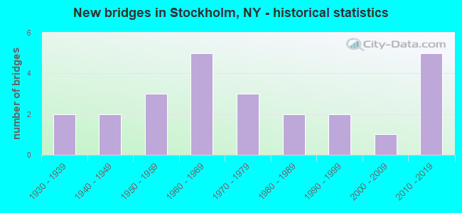
- New bridges - historical statistics
- 21930-1939
- 21940-1949
- 31950-1959
- 51960-1969
- 31970-1979
- 21980-1989
- 21990-1999
- 12000-2009
- 52010-2019

- Reconstructed bridges - Historical Statistics
- 11970-1979
- 11980-1989
- 41990-1999
- 22000-2009


- Bridge Condition - Deck
- 23.8%Excellent
- 19.0%Very good
- 23.8%Good
- 14.3%Satisfactory
- 19.0%Fair

- Bridge Condition - Superstructure
- 33.3%Excellent
- 28.6%Very good
- 14.3%Good
- 9.5%Satisfactory
- 9.5%Fair
- 4.8%Serious

- Bridge Condition - Substructure
- 19.0%Excellent
- 23.8%Very good
- 33.3%Good
- 14.3%Satisfactory
- 4.8%Fair
- 4.8%Poor

- Bridge Condition - Channel
- 12.0%Excellent
- 16.0%Very good
- 28.0%Good
- 36.0%Satisfactory
- 8.0%Fair

- Bridge Condition - Culverts
- 25.0%Good
- 75.0%Satisfactory
Find on map >> Show street view
Structure Number: 100884, Location: 5.1 MI NE JCT US11 & SH56 (Lat: 44.734114, Lng: -74.893100), Route carried "on" structure: US 11, Year Built: 1999, Status: Open, Structure Length: 4.30m (14.11ft), Average Daily Traffic: 2,518 (year 2016), Truck Traffic: 16%, Average Future Daily Traffic: 2,541 (year 2040), Design Load: HS 25 or greater, Features Intersected: W BR ST REGIS RVR
Minimum Vertical Clearance: 30+ m (98+ ft), Kilometerpoint: 77.924, Lanes on structure: 2, Base Highway Network: Yes, Owner: State Highway Agency, Approaching Roadway Width: 11.9m (39.0ft), Material/Design: Steel, Design/Construction: Stringer/Multi-beam, Number Of Spans In Main Unit: 1, Length of Maximum Span: 42.3m (138.8ft), Curb-To-Curb Width: 12.0m (39.4ft), Out-to-Out Width: 13.0m (42.7ft)
Condition: Deck: Fair, Superstructure: Very good, Substructure: Very good, Channel: Excellent, Operating Rating: 69.9 metric tons, Method Used To Determine Operating Rating: Load Factor (LF), Inventory Rating: 41.7 metric tons, Method Used To Determine Inventory Rating: Load Factor (LF), Structural Evaluation: Equal to present desirable criteria, Deck Geometry: Somewhat better than minimum adequacy, Waterway Adequacy: Equal to present desirable criteria, Approach Roadway Alignment: Equal to present desirable criteria, Length Of Structure Improvement: 4.29m (14.07ft), Designated Inspection Frequency: Every 24 months, Inspection Date: November 2021, Bridge Improvement Cost: $1,098,000, Roadway Improvement Cost: $643,000, Total Project Cost: $1,741,000 ( Estimate for 2021), Deck Structure Type: Concrete Cast-file-Place, Wearing Surface/Protective System: Wearing Surface: Integral Concrete, Deck Protection: Epoxy Coated Reinforcing
Find on map >> Show street view
Structure Number: 100885, Location: 1.5 MI SW JCT US 11 & SH4 (Lat: 44.776589, Lng: -74.812756), Route carried "on" structure: US 11C, Year Built: 1996, Status: Open, Structure Length: 4.02m (13.19ft), Average Daily Traffic: 1,790 (year 2020), Truck Traffic: 10%, Average Future Daily Traffic: 1,867 (year 2040), Design Load: HS 25 or greater, Features Intersected: W BR ST REGIS RVR
Minimum Vertical Clearance: 30+ m (98+ ft), Kilometerpoint: 2.156, Lanes on structure: 2, Base Highway Network: Yes, Owner: State Highway Agency, Approaching Roadway Width: 10.4m (34.1ft), Material/Design: Steel, Design/Construction: Stringer/Multi-beam, Number Of Spans In Main Unit: 1, Length of Maximum Span: 39.6m (129.9ft), Curb-To-Curb Width: 10.4m (34.1ft), Out-to-Out Width: 11.0m (36.1ft)
Condition: Deck: Very good, Superstructure: Very good, Substructure: Good, Channel: Good, Operating Rating: 89.8 metric tons, Method Used To Determine Operating Rating: Load Factor (LF), Inventory Rating: 51.7 metric tons, Method Used To Determine Inventory Rating: Load Factor (LF), Structural Evaluation: Better than present minimum criteria, Deck Geometry: Equal to present minimum criteria, Waterway Adequacy: Equal to present desirable criteria, Approach Roadway Alignment: Equal to present desirable criteria, Length Of Structure Improvement: 4.02m (13.19ft), Designated Inspection Frequency: Every 24 months, Inspection Date: May 2020, Bridge Improvement Cost: $853,000, Roadway Improvement Cost: $500,000, Total Project Cost: $1,353,000 ( Estimate for 2021), Deck Structure Type: Concrete Cast-file-Place, Wearing Surface/Protective System: Wearing Surface: Bituminous, Membrane: Other, Deck Protection: Epoxy Coated Reinforcing
Find on map >> Show street view
Structure Number: 100915, Location: 5.2 MI E JCT 11B + 56 (Lat: 44.672308, Lng: -74.866619), Route carried "on" structure: State highway 11B, Year Built: 1971, Status: Open, Structure Length: 11.77m (38.62ft), Average Daily Traffic: 3,220 (year 2016), Truck Traffic: 9%, Average Future Daily Traffic: 3,359 (year 2040), Design Load: HS 20, Features Intersected: WEST BR ST REGIS
Minimum Vertical Clearance: 30+ m (98+ ft), Kilometerpoint: 9.075, Lanes on structure: 2, Base Highway Network: Yes, Owner: State Highway Agency, Approaching Roadway Width: 14.3m (46.9ft), Skew: 1 degrees, Material/Design: Steel continuous, Design/Construction: Stringer/Multi-beam, Number Of Spans In Main Unit: 3, Length of Maximum Span: 44.1m (144.7ft), Curb-To-Curb Width: 14.3m (46.9ft), Out-to-Out Width: 15.2m (49.9ft)
Condition: Deck: Good, Superstructure: Satisfactory, Substructure: Satisfactory, Channel: Very good, Operating Rating: 98.0 metric tons, Method Used To Determine Operating Rating: Field evaluation and documented engineering judgment, Inventory Rating: 32.7 metric tons, Method Used To Determine Inventory Rating: Field evaluation and documented engineering judgment, Structural Evaluation: Equal to present minimum criteria, Deck Geometry: Superior to present desirable criteria, Waterway Adequacy: Equal to present minimum criteria, Approach Roadway Alignment: Equal to present desirable criteria, Length Of Structure Improvement: 11.76m (38.58ft), Designated Inspection Frequency: Every 24 months, Inspection Date: July 2020, Bridge Improvement Cost: $3,331,000, Roadway Improvement Cost: $1,951,000, Total Project Cost: $5,282,000 ( Estimate for 2021), Deck Structure Type: Concrete Cast-file-Place, Wearing Surface/Protective System: Wearing Surface: Monolithic Concrete
Find on map >> Show street view
Structure Number: 104825, Location: 3.3 MI NW JCT RTS 420 +11 (Lat: 44.831542, Lng: -74.829158), Route carried "on" structure: State highway 420, Year Built: 1944, Status: Open, Structure Length: 0.73m (2.40ft), Average Daily Traffic: 2,792 (year 2014), Truck Traffic: 6%, Average Future Daily Traffic: 2,912 (year 2040), Design Load: H 20, Features Intersected: SQUEAK BROOK
Minimum Vertical Clearance: 30+ m (98+ ft), Kilometerpoint: 7.707, Lanes on structure: 2, Base Highway Network: Yes, Owner: State Highway Agency, Approaching Roadway Width: 10.7m (35.1ft), Skew: 1 degrees, Material/Design: Concrete, Design/Construction: Culvert, Number Of Spans In Main Unit: 1, Length of Maximum Span: 7.0m (23.0ft)
Condition: Channel: Satisfactory, Culverts: Good, Operating Rating: 79.8 metric tons, Method Used To Determine Operating Rating: Load Factor (LF), Inventory Rating: 47.2 metric tons, Method Used To Determine Inventory Rating: Load Factor (LF), Structural Evaluation: Better than present minimum criteria, Waterway Adequacy: Meets minimum limits, Approach Roadway Alignment: Better than present minimum criteria, Length Of Structure Improvement: 0.73m (2.40ft), Designated Inspection Frequency: Every 24 months, Inspection Date: May 2021, Bridge Improvement Cost: $318,000, Roadway Improvement Cost: $186,000, Total Project Cost: $504,000 ( Estimate for 2021)
Find on map >> Show street view
Structure Number: 322181, Location: 5.25 MI NE OF PARISHVILLE (Lat: 44.723367, Lng: -74.779311), Route carried "on" structure: Other road , Year Built: 1975, Year Reconstructed: 1993, Status: Open, Structure Length: 0.98m (3.22ft), Average Daily Traffic: 47 (year 2018), Truck Traffic: 4%, Average Future Daily Traffic: 66 (year 2038), Features Intersected: DENJIM BROOK, Facility Carried by Structure: NICHOLS RD
Minimum Vertical Clearance: 30+ m (98+ ft), Kilometerpoint: 2.156, Lanes on structure: 2, Owner: County Highway Agency, Approaching Roadway Width: 5.2m (17.1ft), Material/Design: Steel, Design/Construction: Stringer/Multi-beam, Number Of Spans In Main Unit: 1, Length of Maximum Span: 8.5m (27.9ft), Curb-To-Curb Width: 6.1m (20.0ft), Out-to-Out Width: 7.3m (24.0ft)
Condition: Deck: Good, Superstructure: Very good, Substructure: Very good, Channel: Satisfactory, Operating Rating: 44.1 metric tons, Method Used To Determine Operating Rating: Load and Resistance Factor Rating (LRFR) rating reported by rating factor(RF) method using HL-93 loadings, Inventory Rating: 34.0 metric tons, Method Used To Determine Inventory Rating: Load and Resistance Factor Rating (LRFR) rating reported by rating factor(RF) method using HL-93 loadings, Structural Evaluation: Equal to present desirable criteria, Deck Geometry: Somewhat better than minimum adequacy, Waterway Adequacy: Better than present minimum criteria, Approach Roadway Alignment: Equal to present desirable criteria, Length Of Structure Improvement: 0.97m (3.18ft), Designated Inspection Frequency: Every 24 months, Inspection Date: May 2020, Bridge Improvement Cost: $210,000, Roadway Improvement Cost: $123,000, Total Project Cost: $332,000 ( Estimate for 2021), Deck Structure Type: Open Grating, Wearing Surface/Protective System: Wearing Surface: Other
Find on map >> Show street view
Structure Number: 322182, Location: 3.0 MILES W OF HOPKINTON (Lat: 44.696881, Lng: -74.805539), Route carried "on" structure: County highway , Year Built: 2019, Status: Open, Structure Length: 1.07m (3.51ft), Average Daily Traffic: 15 (year 2018), Truck Traffic: 18%, Average Future Daily Traffic: 21 (year 2038), Features Intersected: TROUT BROOK, Facility Carried by Structure: SULLIVAN ROAD
Minimum Vertical Clearance: 30+ m (98+ ft), Kilometerpoint: 2.269, Lanes on structure: 1, Owner: County Highway Agency, Approaching Roadway Width: 4.9m (16.1ft), Material/Design: Steel, Design/Construction: Stringer/Multi-beam, Number Of Spans In Main Unit: 1, Length of Maximum Span: 9.8m (32.2ft), Curb-To-Curb Width: 4.7m (15.4ft), Out-to-Out Width: 5.2m (17.1ft)
Condition: Deck: Very good, Superstructure: Very good, Substructure: Excellent, Channel: Very good, Structural Evaluation: Equal to present desirable criteria, Deck Geometry: Better than present minimum criteria, Waterway Adequacy: Meets minimum limits, Approach Roadway Alignment: Equal to present desirable criteria, Length Of Structure Improvement: 1.06m (3.48ft), Designated Inspection Frequency: Every 24 months, Inspection Date: October 2021, Bridge Improvement Cost: $145,000, Roadway Improvement Cost: $85,000, Total Project Cost: $230,000 ( Estimate for 2021), Deck Structure Type: Other, Wearing Surface/Protective System: Wearing Surface: Bituminous
Find on map >> Show street view
Structure Number: 334184, Location: .5 MI NE OF STOCKHOLM CTR (Lat: 44.761136, Lng: -74.824053), Route carried "on" structure: US 11, Year Built: 1952, Year Reconstructed: 1990, Status: Open, Structure Length: 2.16m (7.09ft), Average Daily Traffic: 1,850 (year 2016), Truck Traffic: 16%, Average Future Daily Traffic: 1,867 (year 2040), Design Load: H 20, Features Intersected: TROUT BROOK
Minimum Vertical Clearance: 30+ m (98+ ft), Kilometerpoint: 84.199, Lanes on structure: 2, Base Highway Network: Yes, Owner: State Highway Agency, Approaching Roadway Width: 11.0m (36.1ft), Skew: 2 degrees, Material/Design: Steel, Design/Construction: Stringer/Multi-beam, Number Of Spans In Main Unit: 1, Length of Maximum Span: 20.7m (67.9ft), Curb-To-Curb Width: 11.0m (36.1ft), Out-to-Out Width: 11.6m (38.1ft)
Condition: Deck: Good, Superstructure: Very good, Substructure: Good, Channel: Satisfactory, Operating Rating: 61.7 metric tons, Method Used To Determine Operating Rating: Load Factor (LF), Inventory Rating: 33.6 metric tons, Method Used To Determine Inventory Rating: Load Factor (LF), Structural Evaluation: Better than present minimum criteria, Deck Geometry: Equal to present minimum criteria, Waterway Adequacy: Equal to present minimum criteria, Approach Roadway Alignment: Equal to present desirable criteria, Length Of Structure Improvement: 2.16m (7.09ft), Designated Inspection Frequency: Every 24 months, Inspection Date: May 2020, Bridge Improvement Cost: $874,000, Roadway Improvement Cost: $512,000, Total Project Cost: $1,386,000 ( Estimate for 2021), Deck Structure Type: Concrete Cast-file-Place, Wearing Surface/Protective System: Wearing Surface: Integral Concrete, Deck Protection: Epoxy Coated Reinforcing
Find on map >> Show street view
Structure Number: 334185, Location: 3.5 MI NE OF STOCKHOLM CT (Lat: 44.772908, Lng: -74.790561), Route carried "on" structure: US 11, Year Built: 1952, Year Reconstructed: 1990, Status: Open, Structure Length: 5.06m (16.60ft), Average Daily Traffic: 1,850 (year 2016), Truck Traffic: 16%, Average Future Daily Traffic: 1,867 (year 2040), Design Load: HS 20, Features Intersected: E BR ST REGIS RVR
Minimum Vertical Clearance: 30+ m (98+ ft), Kilometerpoint: 87.192, Lanes on structure: 2, Base Highway Network: Yes, Owner: State Highway Agency, Approaching Roadway Width: 11.0m (36.1ft), Skew: 1 degrees, Material/Design: Steel continuous, Design/Construction: Stringer/Multi-beam, Number Of Spans In Main Unit: 2, Length of Maximum Span: 24.3m (79.7ft), Curb-To-Curb Width: 11.0m (36.1ft), Out-to-Out Width: 11.6m (38.1ft)
Condition: Deck: Good, Superstructure: Very good, Substructure: Good, Channel: Satisfactory, Operating Rating: 68.0 metric tons, Method Used To Determine Operating Rating: Load Factor (LF), Inventory Rating: 41.7 metric tons, Method Used To Determine Inventory Rating: Load Factor (LF), Structural Evaluation: Better than present minimum criteria, Deck Geometry: Equal to present minimum criteria, Waterway Adequacy: Somewhat better than minimum adequacy, Approach Roadway Alignment: Equal to present desirable criteria, Length Of Structure Improvement: 5.05m (16.57ft), Designated Inspection Frequency: Every 24 months, Inspection Date: June 2020, Bridge Improvement Cost: $1,374,000, Roadway Improvement Cost: $805,000, Total Project Cost: $2,179,000 ( Estimate for 2021), Deck Structure Type: Concrete Cast-file-Place, Wearing Surface/Protective System: Wearing Surface: Integral Concrete, Deck Protection: Epoxy Coated Reinforcing
Find on map >> Show street view
Structure Number: 334186, Location: 3.5 MI NE OF STOCKHOLM CT (Lat: 44.773556, Lng: -74.789164), Route carried "on" structure: US 11, Year Built: 1952, Year Reconstructed: 1990, Status: Open, Structure Length: 3.11m (10.20ft), Average Daily Traffic: 1,850 (year 2016), Truck Traffic: 16%, Average Future Daily Traffic: 1,867 (year 2040), Design Load: HS 20, Features Intersected: E BR ST REGIS RVR
Minimum Vertical Clearance: 30+ m (98+ ft), Kilometerpoint: 87.304, Lanes on structure: 2, Base Highway Network: Yes, Owner: State Highway Agency, Approaching Roadway Width: 11.0m (36.1ft), Skew: 3 degrees, Material/Design: Steel, Design/Construction: Stringer/Multi-beam, Number Of Spans In Main Unit: 1, Length of Maximum Span: 29.2m (95.8ft), Curb-To-Curb Width: 11.0m (36.1ft), Out-to-Out Width: 11.6m (38.1ft)
Condition: Deck: Satisfactory, Superstructure: Good, Substructure: Good, Channel: Good, Operating Rating: 68.0 metric tons, Method Used To Determine Operating Rating: Load Factor (LF), Inventory Rating: 34.5 metric tons, Method Used To Determine Inventory Rating: Load Factor (LF), Structural Evaluation: Better than present minimum criteria, Deck Geometry: Equal to present minimum criteria, Waterway Adequacy: Somewhat better than minimum adequacy, Approach Roadway Alignment: Better than present minimum criteria, Length Of Structure Improvement: 3.10m (10.17ft), Designated Inspection Frequency: Every 24 months, Inspection Date: June 2020, Bridge Improvement Cost: $1,069,000, Roadway Improvement Cost: $626,000, Total Project Cost: $1,695,000 ( Estimate for 2021), Deck Structure Type: Concrete Cast-file-Place, Wearing Surface/Protective System: Wearing Surface: Integral Concrete, Deck Protection: Epoxy Coated Reinforcing
Find on map >> Show street view
Structure Number: 334187, Location: 6 MI NW OF FORT JACKSON (Lat: 44.755567, Lng: -74.745164), Route carried "on" structure: County highway , Year Built: 1985, Status: Posted for load, Structure Length: 0.73m (2.40ft), Average Daily Traffic: 203 (year 2018), Truck Traffic: 1%, Average Future Daily Traffic: 284 (year 2038), Features Intersected: TROUT BROOK, Facility Carried by Structure: CR 54
Minimum Vertical Clearance: 30+ m (98+ ft), Kilometerpoint: 0.853, Lanes on structure: 2, Owner: County Highway Agency, Approaching Roadway Width: 6.1m (20.0ft), Material/Design: Steel, Design/Construction: Stringer/Multi-beam, Number Of Spans In Main Unit: 1, Length of Maximum Span: 7.0m (23.0ft), Curb-To-Curb Width: 8.3m (27.2ft), Out-to-Out Width: 9.1m (29.9ft)
Condition: Deck: Fair, Superstructure: Serious, Substructure: Satisfactory, Channel: Satisfactory, Operating Rating: 49.0 metric tons, Method Used To Determine Operating Rating: Load Factor (LF), Inventory Rating: 29.0 metric tons, Method Used To Determine Inventory Rating: Load Factor (LF), Structural Evaluation: High priority of corrective action, Deck Geometry: Somewhat better than minimum adequacy, Waterway Adequacy: Meets minimum limits, Approach Roadway Alignment: Equal to present desirable criteria, Bridge Posting: Required (Relationship of Operating Rating to Maximum Legal Load: 20.0 - 29.9% below), Length Of Structure Improvement: 0.73m (2.40ft), Designated Inspection Frequency: Every 12 months, Inspection Date: April 2021, Bridge Improvement Cost: $224,000, Roadway Improvement Cost: $131,000, Total Project Cost: $355,000 ( Estimate for 2021), Deck Structure Type: Wood or Timber, Wearing Surface/Protective System: Wearing Surface: Bituminous
Find on map >> Show street view
Structure Number: 334188, Location: 2.5 MILES N OF SOUTHVILLE (Lat: 44.710875, Lng: -74.843106), Route carried "on" structure: County highway , Year Built: 2013, Status: Open, Structure Length: 3.05m (10.01ft), Average Daily Traffic: 590 (year 2019), Truck Traffic: 13%, Average Future Daily Traffic: 826 (year 2039), Design Load: HL 93, Features Intersected: TROUT BROOK, Facility Carried by Structure: COUNTY ROAD 47
Minimum Vertical Clearance: 30+ m (98+ ft), Kilometerpoint: 4.248, Lanes on structure: 2, Owner: County Highway Agency, Approaching Roadway Width: 9.1m (29.9ft), Skew: 3 degrees, Material/Design: Steel, Design/Construction: Stringer/Multi-beam, Number Of Spans In Main Unit: 1, Length of Maximum Span: 30.2m (99.1ft), Curb-To-Curb Width: 9.3m (30.5ft), Out-to-Out Width: 10.3m (33.8ft)
Condition: Deck: Excellent, Superstructure: Excellent, Substructure: Excellent, Channel: Excellent, Operating Rating: 96.2 metric tons, Method Used To Determine Operating Rating: Load Factor (LF), Inventory Rating: 57.2 metric tons, Method Used To Determine Inventory Rating: Load Factor (LF), Structural Evaluation: Superior to present desirable criteria, Deck Geometry: Equal to present minimum criteria, Waterway Adequacy: Equal to present minimum criteria, Approach Roadway Alignment: Equal to present desirable criteria, Length Of Structure Improvement: 3.04m (9.97ft), Designated Inspection Frequency: Every 24 months, Inspection Date: October 2021, Bridge Improvement Cost: $577,000, Roadway Improvement Cost: $338,000, Total Project Cost: $915,000 ( Estimate for 2021), Deck Structure Type: Concrete Cast-file-Place, Wearing Surface/Protective System: Wearing Surface: Bituminous, Membrane: Other, Deck Protection: Epoxy Coated Reinforcing
Find on map >> Show street view
Structure Number: 334189, Location: .5 MI SE OF STOCKHOLM CTR (Lat: 44.757269, Lng: -74.830842), Route carried "on" structure: County highway , Year Built: 2018, Status: Open, Structure Length: 2.71m (8.89ft), Average Daily Traffic: 556 (year 2019), Truck Traffic: 14%, Average Future Daily Traffic: 778 (year 2039), Features Intersected: TROUT BROOK, Facility Carried by Structure: PRVL-NORFOLK ROAD
Minimum Vertical Clearance: 30+ m (98+ ft), Kilometerpoint: 9.638, Lanes on structure: 2, Owner: County Highway Agency, Approaching Roadway Width: 9.1m (29.9ft), Skew: 1 degrees, Material/Design: Prestressed concrete, Design/Construction: Box Beam or Girders - Multiple, Number Of Spans In Main Unit: 1, Length of Maximum Span: 25.6m (84.0ft), Curb-To-Curb Width: 9.5m (31.2ft), Out-to-Out Width: 10.5m (34.4ft)
Condition: Deck: Excellent, Superstructure: Excellent, Substructure: Very good, Channel: Excellent, Operating Rating: 98.9 metric tons, Method Used To Determine Operating Rating: Load Factor (LF), Inventory Rating: 54.4 metric tons, Method Used To Determine Inventory Rating: Load Factor (LF), Structural Evaluation: Equal to present desirable criteria, Deck Geometry: Equal to present minimum criteria, Waterway Adequacy: Meets minimum limits, Approach Roadway Alignment: Equal to present desirable criteria, Length Of Structure Improvement: 2.71m (8.89ft), Designated Inspection Frequency: Every 24 months, Inspection Date: October 2020, Bridge Improvement Cost: $440,000, Roadway Improvement Cost: $258,000, Total Project Cost: $698,000 ( Estimate for 2021), Wearing Surface/Protective System: Wearing Surface: Bituminous, Membrane: Other
Find on map >> Show street view
Structure Number: 33419, Location: LOCATED IN BROOKDALE (Lat: 44.809069, Lng: -74.896108), Route carried "on" structure: County highway , Year Built: 1938, Year Reconstructed: 2009, Status: Open, Structure Length: 1.28m (4.20ft), Average Daily Traffic: 389 (year 2018), Truck Traffic: 10%, Average Future Daily Traffic: 545 (year 2038), Features Intersected: PLUM BROOK, Facility Carried by Structure: COUNTY ROAD 49
Minimum Vertical Clearance: 30+ m (98+ ft), Kilometerpoint: 9.123, Lanes on structure: 2, Owner: County Highway Agency, Approaching Roadway Width: 6.1m (20.0ft), Material/Design: Steel, Design/Construction: Stringer/Multi-beam, Number Of Spans In Main Unit: 1, Length of Maximum Span: 12.1m (39.7ft), Curb-To-Curb Width: 9.1m (29.9ft), Out-to-Out Width: 10.1m (33.1ft)
Condition: Deck: Excellent, Superstructure: Excellent, Substructure: Very good, Channel: Good, Operating Rating: 97.2 metric tons, Method Used To Determine Operating Rating: Load and Resistance Factor Rating (LRFR) rating reported by rating factor(RF) method using HL-93 loadings, Inventory Rating: 75.5 metric tons, Method Used To Determine Inventory Rating: Load and Resistance Factor Rating (LRFR) rating reported by rating factor(RF) method using HL-93 loadings, Structural Evaluation: Equal to present desirable criteria, Deck Geometry: Equal to present minimum criteria, Waterway Adequacy: Somewhat better than minimum adequacy, Approach Roadway Alignment: Equal to present desirable criteria, Length Of Structure Improvement: 1.28m (4.20ft), Designated Inspection Frequency: Every 24 months, Inspection Date: June 2021, Bridge Improvement Cost: $467,000, Roadway Improvement Cost: $274,000, Total Project Cost: $741,000 ( Estimate for 2021), Deck Structure Type: Concrete Cast-file-Place, Wearing Surface/Protective System: Wearing Surface: Integral Concrete, Deck Protection: Epoxy Coated Reinforcing
Find on map >> Show street view
Structure Number: 334191, Location: 3.3.MI SW OF STOCKHLM CTR (Lat: 44.755217, Lng: -74.865639), Route carried "on" structure: County highway , Year Built: 2015, Status: Open, Structure Length: 2.47m (8.10ft), Average Daily Traffic: 627 (year 2019), Truck Traffic: 8%, Average Future Daily Traffic: 878 (year 2039), Design Load: HL 93, Features Intersected: W BR ST REGIS RVR, Facility Carried by Structure: COUNTY ROAD 47
Minimum Vertical Clearance: 30+ m (98+ ft), Kilometerpoint: 1.239, Lanes on structure: 2, Owner: County Highway Agency, Approaching Roadway Width: 9.1m (29.9ft), Material/Design: Steel, Design/Construction: Stringer/Multi-beam, Number Of Spans In Main Unit: 1, Length of Maximum Span: 24.4m (80.1ft), Curb-To-Curb Width: 9.1m (29.9ft), Out-to-Out Width: 10.1m (33.1ft)
Condition: Deck: Excellent, Superstructure: Excellent, Substructure: Excellent, Channel: Very good, Operating Rating: 88.0 metric tons, Method Used To Determine Operating Rating: Load Factor (LF), Inventory Rating: 52.6 metric tons, Method Used To Determine Inventory Rating: Load Factor (LF), Structural Evaluation: Superior to present desirable criteria, Deck Geometry: Equal to present minimum criteria, Waterway Adequacy: Equal to present desirable criteria, Approach Roadway Alignment: Equal to present desirable criteria, Length Of Structure Improvement: 2.46m (8.07ft), Designated Inspection Frequency: Every 24 months, Inspection Date: October 2021, Bridge Improvement Cost: $524,000, Roadway Improvement Cost: $307,000, Total Project Cost: $831,000 ( Estimate for 2021), Deck Structure Type: Concrete Cast-file-Place, Wearing Surface/Protective System: Wearing Surface: Bituminous, Deck Protection: Epoxy Coated Reinforcing
Find on map >> Show street view
Structure Number: 334192, Location: 3.25 MI SW OF STKHOLM CTR (Lat: 44.754942, Lng: -74.865064), Route carried "on" structure: County highway , Year Built: 2015, Status: Open, Structure Length: 2.47m (8.10ft), Average Daily Traffic: 627 (year 2019), Truck Traffic: 8%, Average Future Daily Traffic: 878 (year 2039), Design Load: HL 93, Features Intersected: W BR ST REGIS RVR, Facility Carried by Structure: COUNTY ROAD 47
Minimum Vertical Clearance: 30+ m (98+ ft), Kilometerpoint: 1.191, Lanes on structure: 2, Owner: County Highway Agency, Approaching Roadway Width: 9.1m (29.9ft), Material/Design: Steel, Design/Construction: Stringer/Multi-beam, Number Of Spans In Main Unit: 1, Length of Maximum Span: 24.4m (80.1ft), Curb-To-Curb Width: 9.1m (29.9ft), Out-to-Out Width: 10.1m (33.1ft)
Condition: Deck: Excellent, Superstructure: Excellent, Substructure: Excellent, Channel: Very good, Operating Rating: 88.0 metric tons, Method Used To Determine Operating Rating: Load Factor (LF), Inventory Rating: 52.6 metric tons, Method Used To Determine Inventory Rating: Load Factor (LF), Structural Evaluation: Superior to present desirable criteria, Deck Geometry: Equal to present minimum criteria, Waterway Adequacy: Equal to present desirable criteria, Approach Roadway Alignment: Equal to present desirable criteria, Length Of Structure Improvement: 2.46m (8.07ft), Designated Inspection Frequency: Every 24 months, Inspection Date: October 2021, Bridge Improvement Cost: $524,000, Roadway Improvement Cost: $307,000, Total Project Cost: $831,000 ( Estimate for 2021), Deck Structure Type: Concrete Cast-file-Place, Wearing Surface/Protective System: Wearing Surface: Bituminous, Deck Protection: Epoxy Coated Reinforcing
Find on map >> Show street view
Structure Number: 334193, Location: LOCATED IN WINTHROP (Lat: 44.790964, Lng: -74.785611), Route carried "on" structure: State highway 420, Year Built: 1949, Year Reconstructed: 2001, Status: Open, Structure Length: 5.12m (16.80ft), Average Daily Traffic: 1,564 (year 2015), Truck Traffic: 10%, Average Future Daily Traffic: 1,631 (year 2040), Features Intersected: W BR ST REGIS RVR
Minimum Vertical Clearance: 30+ m (98+ ft), Kilometerpoint: 1.802, Lanes on structure: 2, Base Highway Network: Yes, Owner: State Highway Agency, Approaching Roadway Width: 6.7m (22.0ft), Material/Design: Steel, Design/Construction: Stringer/Multi-beam, Number Of Spans In Main Unit: 2, Length of Maximum Span: 24.6m (80.7ft), Curb-To-Curb Width: 6.8m (22.3ft), Out-to-Out Width: 7.6m (24.9ft)
Condition: Deck: Fair, Superstructure: Good, Substructure: Good, Channel: Good, Operating Rating: 73.5 metric tons, Method Used To Determine Operating Rating: Load Factor (LF), Inventory Rating: 43.5 metric tons, Method Used To Determine Inventory Rating: Load Factor (LF), Structural Evaluation: Better than present minimum criteria, Deck Geometry: High priority of corrective action, Waterway Adequacy: Equal to present minimum criteria, Approach Roadway Alignment: Equal to present desirable criteria, Length Of Structure Improvement: 5.12m (16.80ft), Designated Inspection Frequency: Every 24 months, Inspection Date: November 2020, Bridge Improvement Cost: $727,000, Roadway Improvement Cost: $426,000, Total Project Cost: $1,152,000 ( Estimate for 2021), Deck Structure Type: Open Grating, Wearing Surface/Protective System: Wearing Surface: Other
Find on map >> Show street view
Structure Number: 334194, Location: 0.5 MI SE OF WINTHROP (Lat: 44.790322, Lng: -74.782783), Route carried "on" structure: County highway , Year Built: 1932, Year Reconstructed: 1978, Status: Open, Structure Length: 3.75m (12.30ft), Average Daily Traffic: 223 (year 2018), Truck Traffic: 5%, Average Future Daily Traffic: 232 (year 2040), Design Load: HS 20, Features Intersected: E BR ST REGIS RVR, Facility Carried by Structure: CR 49, HOPKINTON-
Minimum Vertical Clearance: 30+ m (98+ ft), Kilometerpoint: 2.108, Lanes on structure: 2, Owner: County Highway Agency, Approaching Roadway Width: 6.1m (20.0ft), Material/Design: Steel, Design/Construction: Stringer/Multi-beam, Number Of Spans In Main Unit: 2, Length of Maximum Span: 18.2m (59.7ft), Curb-To-Curb Width: 7.4m (24.3ft), Out-to-Out Width: 7.8m (25.6ft)
Condition: Deck: Fair, Superstructure: Satisfactory, Substructure: Satisfactory, Channel: Satisfactory, Operating Rating: 85.3 metric tons, Method Used To Determine Operating Rating: Load Factor (LF), Inventory Rating: 50.8 metric tons, Method Used To Determine Inventory Rating: Load Factor (LF), Structural Evaluation: Equal to present minimum criteria, Deck Geometry: Somewhat better than minimum adequacy, Waterway Adequacy: Meets minimum limits, Approach Roadway Alignment: Meets minimum limits, Length Of Structure Improvement: 3.74m (12.27ft), Designated Inspection Frequency: Every 24 months, Inspection Date: June 2020, Bridge Improvement Cost: $701,000, Roadway Improvement Cost: $411,000, Total Project Cost: $1,112,000 ( Estimate for 2021), Deck Structure Type: Open Grating, Wearing Surface/Protective System: Wearing Surface: Other
Find on map >> Show street view
Structure Number: 334195, Location: 1.25 MILES SW OF WINTHROP (Lat: 44.782203, Lng: -74.780039), Route carried "on" structure: State highway 420, Year Built: 1965, Status: Open, Structure Length: 7.50m (24.61ft), Average Daily Traffic: 1,564 (year 2015), Truck Traffic: 10%, Average Future Daily Traffic: 1,631 (year 2040), Design Load: HS 20, Features Intersected: E BR ST REGIS RVR
Minimum Vertical Clearance: 30+ m (98+ ft), Kilometerpoint: 0.708, Lanes on structure: 2, Base Highway Network: Yes, Owner: State Highway Agency, Approaching Roadway Width: 8.5m (27.9ft), Material/Design: Steel, Design/Construction: Stringer/Multi-beam, Number Of Spans In Main Unit: 2, Length of Maximum Span: 36.5m (119.8ft), Curb-To-Curb Width: 8.8m (28.9ft), Out-to-Out Width: 9.4m (30.8ft)
Condition: Deck: Good, Superstructure: Good, Substructure: Good, Channel: Good, Operating Rating: 68.9 metric tons, Method Used To Determine Operating Rating: Load Factor (LF), Inventory Rating: 34.5 metric tons, Method Used To Determine Inventory Rating: Load Factor (LF), Structural Evaluation: Better than present minimum criteria, Deck Geometry: Somewhat better than minimum adequacy, Waterway Adequacy: Somewhat better than minimum adequacy, Approach Roadway Alignment: Equal to present desirable criteria, Length Of Structure Improvement: 7.49m (24.57ft), Designated Inspection Frequency: Every 24 months, Inspection Date: June 2021, Bridge Improvement Cost: $1,339,000, Roadway Improvement Cost: $784,000, Total Project Cost: $2,123,000 ( Estimate for 2021), Deck Structure Type: Concrete Cast-file-Place, Wearing Surface/Protective System: Wearing Surface: Integral Concrete
Find on map >> Show street view
Structure Number: 334196, Location: 5.75 MI NE OF PARISHVILLE (Lat: 44.741303, Lng: -74.781250), Route carried "on" structure: Other road , Year Built: 1964, Status: Open, Structure Length: 5.00m (16.40ft), Average Daily Traffic: 278 (year 2018), Truck Traffic: 7%, Average Future Daily Traffic: 389 (year 2038), Features Intersected: E BR ST REGIS RIV, Facility Carried by Structure: BUCKTON ROAD
Minimum Vertical Clearance: 30+ m (98+ ft), Kilometerpoint: 5.905, Lanes on structure: 2, Owner: County Highway Agency, Approaching Roadway Width: 5.5m (18.0ft), Material/Design: Steel, Design/Construction: Stringer/Multi-beam, Number Of Spans In Main Unit: 2, Length of Maximum Span: 24.0m (78.7ft), Curb-To-Curb Width: 7.3m (24.0ft), Out-to-Out Width: 7.3m (24.0ft)
Condition: Deck: Satisfactory, Superstructure: Fair, Substructure: Fair, Channel: Satisfactory, Operating Rating: 72.6 metric tons, Method Used To Determine Operating Rating: Load Factor (LF), Inventory Rating: 43.5 metric tons, Method Used To Determine Inventory Rating: Load Factor (LF), Structural Evaluation: Somewhat better than minimum adequacy, Deck Geometry: Somewhat better than minimum adequacy, Waterway Adequacy: Somewhat better than minimum adequacy, Approach Roadway Alignment: Equal to present desirable criteria, Length Of Structure Improvement: 4.99m (16.37ft), Designated Inspection Frequency: Every 24 months, Inspection Date: August 2021, Bridge Improvement Cost: $928,000, Roadway Improvement Cost: $543,000, Total Project Cost: $1,471,000 ( Estimate for 2021), Deck Structure Type: Open Grating, Wearing Surface/Protective System: Wearing Surface: Other
Find on map >> Show street view
Structure Number: 334197, Location: 4.0 MI NE OF SOUTHVILLE (Lat: 44.727089, Lng: -74.856908), Route carried "on" structure: Other road , Year Built: 1965, Year Reconstructed: 2012, Status: Open, Structure Length: 1.71m (5.61ft), Average Daily Traffic: 84 (year 2018), Truck Traffic: 7%, Average Future Daily Traffic: 118 (year 2038), Features Intersected: TROUT BROOK, Facility Carried by Structure: REAGAN STREET
Minimum Vertical Clearance: 30+ m (98+ ft), Kilometerpoint: 1.995, Lanes on structure: 2, Owner: County Highway Agency, Approaching Roadway Width: 5.2m (17.1ft), Material/Design: Steel, Design/Construction: Stringer/Multi-beam, Number Of Spans In Main Unit: 1, Length of Maximum Span: 15.5m (50.9ft), Curb-To-Curb Width: 7.3m (24.0ft), Out-to-Out Width: 7.3m (24.0ft)
Condition: Deck: Very good, Superstructure: Excellent, Substructure: Good, Channel: Good, Operating Rating: 33.0 metric tons, Method Used To Determine Operating Rating: Load and Resistance Factor Rating (LRFR) rating reported by rating factor(RF) method using HL-93 loadings, Inventory Rating: 25.6 metric tons, Method Used To Determine Inventory Rating: Load and Resistance Factor Rating (LRFR) rating reported by rating factor(RF) method using HL-93 loadings, Structural Evaluation: Equal to present minimum criteria, Deck Geometry: Equal to present minimum criteria, Waterway Adequacy: Somewhat better than minimum adequacy, Approach Roadway Alignment: Meets minimum limits, Length Of Structure Improvement: 1.70m (5.58ft), Designated Inspection Frequency: Every 24 months, Inspection Date: May 2021, Bridge Improvement Cost: $359,000, Roadway Improvement Cost: $210,000, Total Project Cost: $569,000 ( Estimate for 2021), Deck Structure Type: Open Grating, Wearing Surface/Protective System: Wearing Surface: Other
Find on map >> Show street view
Structure Number: 334198, Location: 4.5 MI NW OF PARISHVILLE (Lat: 44.699942, Lng: -74.836436), Route carried "on" structure: Other road , Year Built: 1960, Status: Open, Structure Length: 1.22m (4.00ft), Average Daily Traffic: 48 (year 2018), Average Future Daily Traffic: 67 (year 2038), Features Intersected: TROUT BROOK, Facility Carried by Structure: MCINTYRE ROAD
Minimum Vertical Clearance: 30+ m (98+ ft), Kilometerpoint: 2.381, Lanes on structure: 2, Owner: County Highway Agency, Approaching Roadway Width: 5.2m (17.1ft), Material/Design: Steel, Design/Construction: Culvert, Number Of Spans In Main Unit: 2, Length of Maximum Span: 5.4m (17.7ft)
Condition: Channel: Fair, Culverts: Satisfactory, Operating Rating: 76.5 metric tons, Method Used To Determine Operating Rating: Field evaluation and documented engineering judgment, Inventory Rating: 32.7 metric tons, Method Used To Determine Inventory Rating: Field evaluation and documented engineering judgment, Structural Evaluation: Equal to present minimum criteria, Waterway Adequacy: Meets minimum limits, Approach Roadway Alignment: Meets minimum limits, Length Of Structure Improvement: 1.21m (3.97ft), Designated Inspection Frequency: Every 24 months, Inspection Date: May 2021, Bridge Improvement Cost: $126,000, Roadway Improvement Cost: $74,000, Total Project Cost: $200,000 ( Estimate for 2021)
Find on map >> Show street view
Structure Number: 334199, Location: 5 MI NW OF PARISHVILLE (Lat: 44.702344, Lng: -74.842933), Route carried "on" structure: Other road , Year Built: 1967, Status: Open, Structure Length: 1.34m (4.40ft), Average Daily Traffic: 48 (year 2018), Average Future Daily Traffic: 67 (year 2038), Features Intersected: TROUT BROOK, Facility Carried by Structure: MCINTYRE ROAD
Minimum Vertical Clearance: 30+ m (98+ ft), Kilometerpoint: 2.993, Lanes on structure: 2, Owner: County Highway Agency, Approaching Roadway Width: 5.2m (17.1ft), Material/Design: Steel, Design/Construction: Culvert, Number Of Spans In Main Unit: 2, Length of Maximum Span: 5.4m (17.7ft)
Condition: Channel: Fair, Culverts: Satisfactory, Operating Rating: 76.5 metric tons, Method Used To Determine Operating Rating: Field evaluation and documented engineering judgment, Inventory Rating: 32.7 metric tons, Method Used To Determine Inventory Rating: Field evaluation and documented engineering judgment, Structural Evaluation: Equal to present minimum criteria, Waterway Adequacy: Meets minimum limits, Approach Roadway Alignment: Meets minimum limits, Length Of Structure Improvement: 1.34m (4.40ft), Designated Inspection Frequency: Every 24 months, Inspection Date: May 2021, Bridge Improvement Cost: $139,000, Roadway Improvement Cost: $81,000, Total Project Cost: $220,000 ( Estimate for 2021)
Find on map >> Show street view
Structure Number: 3342, Location: LOCATED IN WEST STOCKHOLM (Lat: 44.713514, Lng: -74.900383), Route carried "on" structure: Business County highway , Year Built: 2000, Status: Open, Structure Length: 4.79m (15.72ft), Average Daily Traffic: 532 (year 2018), Truck Traffic: 4%, Average Future Daily Traffic: 745 (year 2038), Design Load: HS 25 or greater, Features Intersected: W BR ST REGIS RIV, Facility Carried by Structure: CR 57, WESTSTOCKO
Minimum Vertical Clearance: 30+ m (98+ ft), Kilometerpoint: 0.000, Lanes on structure: 1, Owner: County Highway Agency, Approaching Roadway Width: 6.7m (22.0ft), Material/Design: Steel continuous, Design/Construction: Stringer/Multi-beam, Number Of Spans In Main Unit: 2, Length of Maximum Span: 23.1m (75.8ft), Curb or Sidewalk Widths: Left: 1.8m (5.9ft), Right: 0.0m, Curb-To-Curb Width: 4.9m (16.1ft), Out-to-Out Width: 6.2m (20.3ft)
Condition: Deck: Very good, Superstructure: Excellent, Substructure: Very good, Channel: Good, Operating Rating: 72.6 metric tons, Method Used To Determine Operating Rating: Load Factor (LF), Inventory Rating: 43.5 metric tons, Method Used To Determine Inventory Rating: Load Factor (LF), Structural Evaluation: Equal to present desirable criteria, Deck Geometry: High priority of replacement, Waterway Adequacy: Equal to present minimum criteria, Approach Roadway Alignment: Equal to present minimum criteria, Length Of Structure Improvement: 4.78m (15.68ft), Designated Inspection Frequency: Every 24 months, Underwater Inspection Frequency: Every 60 months, Inspection Date: June 2020, Underwater Inspection Date: August 2017, Bridge Improvement Cost: $601,000, Roadway Improvement Cost: $352,000, Total Project Cost: $954,000 ( Estimate for 2021), Deck Structure Type: Concrete Cast-file-Place, Wearing Surface/Protective System: Wearing Surface: Monolithic Concrete, Deck Protection: Epoxy Coated Reinforcing
Find on map >> Show street view
Structure Number: 335837, Location: 2 MI NE OF STOCKHOLM CNTR (Lat: 44.785739, Lng: -74.814683), Route carried "on" structure: Other road , Year Built: 1971, Status: Posted for load, Structure Length: 2.47m (8.10ft), Average Daily Traffic: 77 (year 2018), Truck Traffic: 2%, Average Future Daily Traffic: 108 (year 2038), Features Intersected: W BR ST REGIS RVR, Facility Carried by Structure: MC CARTHY ROAD
Minimum Vertical Clearance: 30+ m (98+ ft), Kilometerpoint: 5.760, Lanes on structure: 2, Owner: County Highway Agency, Approaching Roadway Width: 5.8m (19.0ft), Material/Design: Steel, Design/Construction: Stringer/Multi-beam, Number Of Spans In Main Unit: 1, Length of Maximum Span: 22.8m (74.8ft), Curb-To-Curb Width: 7.3m (24.0ft), Out-to-Out Width: 7.8m (25.6ft)
Condition: Deck: Satisfactory, Superstructure: Fair, Substructure: Poor, Channel: Satisfactory, Operating Rating: 12.7 metric tons, Method Used To Determine Operating Rating: Load Factor (LF), Inventory Rating: 7.3 metric tons, Method Used To Determine Inventory Rating: Load Factor (LF), Structural Evaluation: High priority of corrective action, Deck Geometry: Equal to present minimum criteria, Waterway Adequacy: Meets minimum limits, Approach Roadway Alignment: Equal to present minimum criteria, Bridge Posting: Required (Relationship of Operating Rating to Maximum Legal Load: > 39.9% below), Length Of Structure Improvement: 2.46m (8.07ft), Designated Inspection Frequency: Every 12 months, Inspection Date: September 2021, Bridge Improvement Cost: $576,000, Roadway Improvement Cost: $338,000, Total Project Cost: $914,000 ( Estimate for 2021), Deck Structure Type: Open Grating, Wearing Surface/Protective System: Wearing Surface: Other
Find on map >> Show street view
Structure Number: 336746, Location: 5 MI S OF WINTHROP (Lat: 44.729986, Lng: -74.778522), Route carried "on" structure: Other road , Year Built: 1985, Status: Open, Structure Length: 0.64m (2.10ft), Average Daily Traffic: 47 (year 2018), Truck Traffic: 4%, Average Future Daily Traffic: 66 (year 2038), Features Intersected: DENJIM BROOK, Facility Carried by Structure: NICHOLS ROAD
Minimum Vertical Clearance: 30+ m (98+ ft), Kilometerpoint: 3.250, Lanes on structure: 2, Owner: Town or Township Highway Agency, Approaching Roadway Width: 5.8m (19.0ft), Material/Design: Steel, Design/Construction: Culvert, Number Of Spans In Main Unit: 3, Length of Maximum Span: 1.8m (5.9ft)
Condition: Channel: Satisfactory, Culverts: Satisfactory, Operating Rating: 73.8 metric tons, Method Used To Determine Operating Rating: Field evaluation and documented engineering judgment, Inventory Rating: 32.7 metric tons, Method Used To Determine Inventory Rating: Field evaluation and documented engineering judgment, Structural Evaluation: Equal to present minimum criteria, Waterway Adequacy: Superior to present desirable criteria, Approach Roadway Alignment: Better than present minimum criteria, Length Of Structure Improvement: 0.64m (2.10ft), Designated Inspection Frequency: Every 24 months, Inspection Date: April 2021, Bridge Improvement Cost: $74,000, Roadway Improvement Cost: $44,000, Total Project Cost: $118,000 ( Estimate for 2021)