Bridge Statistics for Stonewall, Texas (TX)
Condition, Traffic, Stress, Structural Evaluation, Project Costs
- National Bridge Inventory (NBI) Statistics
- 20Number of bridges
- 207ft / 62.6mTotal length
- $217,000Total costs
- 74,878Total average daily traffic
- 10,372Total average daily truck traffic
- 57,885Total future (year 2027) average daily traffic
- National Bridge Inventory (NBI) Registered Bridges for Stonewall
- No street view available for this location
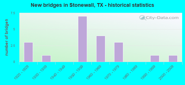
- New bridges - historical statistics
- 31920-1929
- 11930-1939
- 71950-1959
- 41960-1969
- 31970-1979
- 11990-1999
- 12000-2009

- Reconstructed bridges - Historical Statistics
- 51960-1969
- 21970-1979
- 01980-1989
- 01990-1999
- 22000-2009


- Bridge Condition - Deck
- 75.0%Good
- 25.0%Satisfactory

- Bridge Condition - Superstructure
- 62.5%Good
- 25.0%Satisfactory
- 12.5%Fair

- Bridge Condition - Substructure
- 25.0%Good
- 62.5%Satisfactory
- 12.5%Fair

- Bridge Condition - Channel
- 5.0%Very good
- 50.0%Good
- 35.0%Satisfactory
- 5.0%Fair
- 5.0%Poor

- Bridge Condition - Culverts
- 66.7%Good
- 25.0%Satisfactory
- 8.3%Poor
Find on map >> Show street view
Structure Number: 140160011303043, Location: 2.0 MI W OF FM 1320 (Lat: 30.240744, Lng: -98.580706), Route carried "on" structure: US 290, Year Built: 1955, Year Reconstructed: 1966, Status: Open, Structure Length: 6.10m (20.01ft), Average Daily Traffic: 7,316 (year 2020), Truck Traffic: 14%, Average Future Daily Traffic: 5,630 (year 2033), Features Intersected: WILLIAMS CREEK
Minimum Vertical Clearance: 30+ m (98+ ft), Kilometerpoint: 0.705, Lanes on structure: 4, Owner: State Highway Agency, Approaching Roadway Width: 15.9m (52.2ft), Material/Design: Concrete continuous, Design/Construction: Slab, Number Of Spans In Main Unit: 8, Length of Maximum Span: 7.6m (24.9ft), Curb-To-Curb Width: 15.9m (52.2ft), Out-to-Out Width: 16.6m (54.5ft)
Condition: Deck: Good, Superstructure: Good, Substructure: Good, Channel: Satisfactory, Operating Rating: 58.0 metric tons, Method Used To Determine Operating Rating: Load Factor (LF), Inventory Rating: 34.5 metric tons, Method Used To Determine Inventory Rating: Load Factor (LF), Structural Evaluation: Better than present minimum criteria, Deck Geometry: Meets minimum limits, Waterway Adequacy: Equal to present minimum criteria, Approach Roadway Alignment: Equal to present desirable criteria, Length Of Structure Improvement: 6.10m (20.01ft), Designated Inspection Frequency: Every 24 months, Inspection Date: April 2021, Deck Structure Type: Concrete Cast-file-Place, Wearing Surface/Protective System: Wearing Surface: Bituminous
Find on map >> Show street view
Structure Number: 140160011303044, Location: 0.05 MI E OF RR 1 (Lat: 30.241661, Lng: -98.575561), Route carried "on" structure: US 290, Year Built: 1955, Year Reconstructed: 1971, Status: Open, Structure Length: 0.79m (2.59ft), Average Daily Traffic: 7,564 (year 2020), Truck Traffic: 14%, Average Future Daily Traffic: 5,830 (year 2033), Features Intersected: DRAW
Minimum Vertical Clearance: 30+ m (98+ ft), Kilometerpoint: 1.204, Lanes on structure: 4, Owner: State Highway Agency, Approaching Roadway Width: 16.5m (54.1ft), Material/Design: Concrete, Design/Construction: Culvert, Number Of Spans In Main Unit: 3, Length of Maximum Span: 2.4m (7.9ft), Curb-To-Curb Width: 19.0m (62.3ft), Out-to-Out Width: 21.6m (70.9ft)
Condition: Channel: Good, Culverts: Good, Operating Rating: 32.7 metric tons, Method Used To Determine Operating Rating: Field evaluation and documented engineering judgment, Inventory Rating: 24.5 metric tons, Method Used To Determine Inventory Rating: Field evaluation and documented engineering judgment, Structural Evaluation: Equal to present minimum criteria, Deck Geometry: Equal to present minimum criteria, Waterway Adequacy: Equal to present minimum criteria, Approach Roadway Alignment: Equal to present desirable criteria, Designated Inspection Frequency: Every 24 months, Inspection Date: April 2021, Deck Structure Type: Concrete Cast-file-Place, Wearing Surface/Protective System: Wearing Surface: Bituminous
Find on map >> Show street view
Structure Number: 140160011316009, Location: 0.3 MI W OF US 290 (Lat: 30.242861, Lng: -98.580283), Route carried "on" structure: State highway 1, Year Built: 1924, Status: Open, Structure Length: 3.02m (9.91ft), Average Daily Traffic: 337 (year 2020), Truck Traffic: 5%, Average Future Daily Traffic: 150 (year 2033), Design Load: H 15, Features Intersected: WILLIAMS CREEK
Minimum Vertical Clearance: 30+ m (98+ ft), Kilometerpoint: 0.861, Lanes on structure: 2, Owner: State Highway Agency, Approaching Roadway Width: 7.3m (24.0ft), Material/Design: Concrete, Design/Construction: Tee Beam, Number Of Spans In Main Unit: 3, Length of Maximum Span: 10.1m (33.1ft), Curb-To-Curb Width: 6.7m (22.0ft), Out-to-Out Width: 7.1m (23.3ft)
Condition: Deck: Good, Superstructure: Satisfactory, Substructure: Satisfactory, Channel: Satisfactory, Operating Rating: 53.5 metric tons, Method Used To Determine Operating Rating: Load Factor (LF), Inventory Rating: 31.7 metric tons, Method Used To Determine Inventory Rating: Load Factor (LF), Structural Evaluation: Equal to present minimum criteria, Deck Geometry: Meets minimum limits, Waterway Adequacy: Equal to present minimum criteria, Approach Roadway Alignment: Better than present minimum criteria, Length Of Structure Improvement: 2.99m (9.81ft), Designated Inspection Frequency: Every 24 months, Inspection Date: April 2021, Deck Structure Type: Concrete Cast-file-Place, Wearing Surface/Protective System: Wearing Surface: Bituminous
Find on map >> Show street view
Structure Number: 140870011302038, Location: 3.6 MI W OF FM 1623 S (Lat: 30.220736, Lng: -98.708919), Route carried "on" structure: US 290, Year Built: 1955, Year Reconstructed: 1970, Status: Open, Structure Length: 1.01m (3.31ft), Average Daily Traffic: 9,990 (year 2020), Truck Traffic: 14%, Average Future Daily Traffic: 6,760 (year 2033), Features Intersected: DRAW
Minimum Vertical Clearance: 30+ m (98+ ft), Kilometerpoint: 17.743, Lanes on structure: 5, Owner: State Highway Agency, Approaching Roadway Width: 21.3m (69.9ft), Material/Design: Concrete, Design/Construction: Culvert, Number Of Spans In Main Unit: 3, Length of Maximum Span: 3.0m (9.8ft), Curb-To-Curb Width: 21.4m (70.2ft), Out-to-Out Width: 30.4m (99.7ft)
Condition: Channel: Satisfactory, Culverts: Good, Operating Rating: 39.9 metric tons, Method Used To Determine Operating Rating: Load Factor (LF), Inventory Rating: 23.6 metric tons, Method Used To Determine Inventory Rating: Load Factor (LF), Structural Evaluation: Somewhat better than minimum adequacy, Deck Geometry: Somewhat better than minimum adequacy, Waterway Adequacy: Equal to present minimum criteria, Approach Roadway Alignment: Equal to present desirable criteria, Designated Inspection Frequency: Every 24 months, Inspection Date: April 2021, Deck Structure Type: Concrete Cast-file-Place, Wearing Surface/Protective System: Wearing Surface: Bituminous
Find on map >> Show street view
Structure Number: 140870011302039, Location: 2.7 MI W OF FM 1623 S (Lat: 30.221536, Lng: -98.693131), Route carried "on" structure: US 290, Year Built: 1955, Year Reconstructed: 1970, Status: Open, Structure Length: 1.13m (3.71ft), Average Daily Traffic: 9,990 (year 2020), Truck Traffic: 14%, Average Future Daily Traffic: 6,760 (year 2033), Features Intersected: GELLERMAN BRANCH
Minimum Vertical Clearance: 30+ m (98+ ft), Kilometerpoint: 19.277, Lanes on structure: 4, Owner: State Highway Agency, Approaching Roadway Width: 15.9m (52.2ft), Skew: 4 degrees, Material/Design: Concrete, Design/Construction: Culvert, Number Of Spans In Main Unit: 3, Length of Maximum Span: 2.4m (7.9ft)
Condition: Channel: Good, Culverts: Good, Operating Rating: 32.7 metric tons, Method Used To Determine Operating Rating: Field evaluation and documented engineering judgment, Inventory Rating: 24.5 metric tons, Method Used To Determine Inventory Rating: Field evaluation and documented engineering judgment, Structural Evaluation: Equal to present minimum criteria, Waterway Adequacy: Equal to present minimum criteria, Approach Roadway Alignment: Equal to present desirable criteria, Designated Inspection Frequency: Every 24 months, Inspection Date: April 2021
Find on map >> Show street view
Structure Number: 14087001130204, Location: 12.6 MI E OF US 87 (Lat: 30.227372, Lng: -98.681511), Route carried "on" structure: US 290, Year Built: 1955, Year Reconstructed: 1966, Status: Open, Structure Length: 4.82m (15.81ft), Average Daily Traffic: 9,990 (year 2020), Truck Traffic: 14%, Average Future Daily Traffic: 6,760 (year 2033), Design Load: H 20, Features Intersected: THREE MILE CREEK
Minimum Vertical Clearance: 30+ m (98+ ft), Kilometerpoint: 20.569, Lanes on structure: 4, Owner: State Highway Agency, Approaching Roadway Width: 15.9m (52.2ft), Skew: 4 degrees, Material/Design: Concrete, Design/Construction: Slab, Number Of Spans In Main Unit: 6, Length of Maximum Span: 7.9m (25.9ft), Curb-To-Curb Width: 15.9m (52.2ft), Out-to-Out Width: 16.6m (54.5ft)
Condition: Deck: Satisfactory, Superstructure: Satisfactory, Substructure: Satisfactory, Channel: Good, Operating Rating: 38.1 metric tons, Method Used To Determine Operating Rating: Load Factor (LF), Inventory Rating: 22.7 metric tons, Method Used To Determine Inventory Rating: Load Factor (LF), Structural Evaluation: Somewhat better than minimum adequacy, Deck Geometry: Meets minimum limits, Waterway Adequacy: Equal to present minimum criteria, Approach Roadway Alignment: Equal to present desirable criteria, Bridge Posting: Required (Relationship of Operating Rating to Maximum Legal Load: 10.0 - 19.9% below), Length Of Structure Improvement: 4.79m (15.72ft), Designated Inspection Frequency: Every 24 months, Inspection Date: April 2021, Bridge Improvement Cost: $163,000, Roadway Improvement Cost: $41,000, Total Project Cost: $204,000, Deck Structure Type: Concrete Cast-file-Place, Wearing Surface/Protective System: Wearing Surface: Bituminous
Find on map >> Show street view
Structure Number: 140870011302041, Location: 0.9 MI E OF FM 1623 S (Lat: 30.234833, Lng: -98.637150), Route carried "on" structure: US 290, Year Built: 1955, Year Reconstructed: 1971, Status: Open, Structure Length: 1.40m (4.59ft), Average Daily Traffic: 7,761 (year 2020), Truck Traffic: 14%, Average Future Daily Traffic: 7,250 (year 2033), Features Intersected: DRAW
Minimum Vertical Clearance: 30+ m (98+ ft), Kilometerpoint: 25.278, Lanes on structure: 4, Owner: State Highway Agency, Approaching Roadway Width: 17.1m (56.1ft), Skew: 4 degrees, Material/Design: Concrete, Design/Construction: Culvert, Number Of Spans In Main Unit: 3, Length of Maximum Span: 3.0m (9.8ft), Curb-To-Curb Width: 17.1m (56.1ft), Out-to-Out Width: 26.9m (88.3ft)
Condition: Channel: Satisfactory, Culverts: Satisfactory, Operating Rating: 32.7 metric tons, Method Used To Determine Operating Rating: Field evaluation and documented engineering judgment, Inventory Rating: 24.5 metric tons, Method Used To Determine Inventory Rating: Field evaluation and documented engineering judgment, Structural Evaluation: Equal to present minimum criteria, Deck Geometry: Somewhat better than minimum adequacy, Waterway Adequacy: Equal to present minimum criteria, Approach Roadway Alignment: Equal to present desirable criteria, Designated Inspection Frequency: Every 24 months, Inspection Date: April 2021, Deck Structure Type: Concrete Cast-file-Place, Wearing Surface/Protective System: Wearing Surface: Bituminous
Find on map >> Show street view
Structure Number: 140870011302042, Location: 1.6 MI E OF FM 1623 S (Lat: 30.234422, Lng: -98.625189), Route carried "on" structure: US 290, Year Built: 1955, Year Reconstructed: 1971, Status: Open, Structure Length: 0.82m (2.69ft), Average Daily Traffic: 7,761 (year 2020), Truck Traffic: 14%, Average Future Daily Traffic: 7,250 (year 2033), Features Intersected: ARNELOER BRANCH
Minimum Vertical Clearance: 30+ m (98+ ft), Kilometerpoint: 26.419, Lanes on structure: 4, Owner: State Highway Agency, Approaching Roadway Width: 16.5m (54.1ft), Material/Design: Concrete, Design/Construction: Culvert, Number Of Spans In Main Unit: 3, Length of Maximum Span: 2.4m (7.9ft), Curb-To-Curb Width: 16.9m (55.4ft), Out-to-Out Width: 26.0m (85.3ft)
Condition: Channel: Satisfactory, Culverts: Good, Operating Rating: 32.7 metric tons, Method Used To Determine Operating Rating: Field evaluation and documented engineering judgment, Inventory Rating: 24.5 metric tons, Method Used To Determine Inventory Rating: Field evaluation and documented engineering judgment, Structural Evaluation: Equal to present minimum criteria, Deck Geometry: Somewhat better than minimum adequacy, Waterway Adequacy: Equal to present minimum criteria, Approach Roadway Alignment: Equal to present desirable criteria, Designated Inspection Frequency: Every 24 months, Inspection Date: April 2021, Deck Structure Type: Concrete Cast-file-Place, Wearing Surface/Protective System: Wearing Surface: Bituminous
Find on map >> Show street view
Structure Number: 140870011302468, Location: 9.9 MI E OF US 87 (Lat: 30.223261, Lng: -98.725861), Route carried "on" structure: US 290, Year Built: 2008, Status: Open, Structure Length: 7.32m (24.02ft), Average Daily Traffic: 9,990 (year 2020), Truck Traffic: 14%, Average Future Daily Traffic: 6,760 (year 2033), Design Load: HL 93, Features Intersected: SOUTH GRAPE CREEK
Minimum Vertical Clearance: 30+ m (98+ ft), Kilometerpoint: 16.081, Lanes on structure: 5, Owner: State Highway Agency, Approaching Roadway Width: 15.9m (52.2ft), Skew: 4 degrees, Material/Design: Prestressed concrete, Design/Construction: Stringer/Multi-beam, Number Of Spans In Main Unit: 3, Length of Maximum Span: 24.4m (80.1ft), Curb-To-Curb Width: 24.8m (81.4ft), Out-to-Out Width: 25.6m (84.0ft)
Condition: Deck: Good, Superstructure: Good, Substructure: Good, Channel: Good, Operating Rating: 54.4 metric tons, Method Used To Determine Operating Rating: Assigned ratings based on Load and Resistance Factor Design (LRFD) reported in metric tons, Inventory Rating: 32.7 metric tons, Method Used To Determine Inventory Rating: Assigned ratings based on Load and Resistance Factor Design (LRFD) reported in metric tons, Structural Evaluation: Better than present minimum criteria, Deck Geometry: Superior to present desirable criteria, Waterway Adequacy: Equal to present minimum criteria, Approach Roadway Alignment: Equal to present desirable criteria, Designated Inspection Frequency: Every 24 months, Inspection Date: April 2021, Deck Structure Type: Concrete Precast Panels
Find on map >> Show street view
Structure Number: 140870011317074, Location: 0.1 MI N OF RR 1 (Lat: 30.242153, Lng: -98.605475), Route carried "on" structure: State highway 49, Year Built: 1968, Status: Open, Structure Length: 9.14m (29.99ft), Average Daily Traffic: 230 (year 2013), Truck Traffic: 14%, Average Future Daily Traffic: 320 (year 2033), Features Intersected: PEDERNALES RIVER
Minimum Vertical Clearance: 30+ m (98+ ft), Kilometerpoint: 0.061, Lanes on structure: 2, Owner: State Highway Agency, Approaching Roadway Width: 7.6m (24.9ft), Material/Design: Concrete continuous, Design/Construction: Slab, Number Of Spans In Main Unit: 11, Length of Maximum Span: 9.1m (29.9ft), Curb-To-Curb Width: 7.9m (25.9ft), Out-to-Out Width: 8.6m (28.2ft)
Condition: Deck: Good, Superstructure: Good, Substructure: Satisfactory, Channel: Good, Operating Rating: 46.3 metric tons, Method Used To Determine Operating Rating: Load and Resistance Factor (LRFR), Inventory Rating: 27.2 metric tons, Method Used To Determine Inventory Rating: Load and Resistance Factor (LRFR), Structural Evaluation: Equal to present minimum criteria, Deck Geometry: Somewhat better than minimum adequacy, Waterway Adequacy: Meets minimum limits, Approach Roadway Alignment: Equal to present desirable criteria, Designated Inspection Frequency: Every 24 months, Inspection Date: April 2021, Deck Structure Type: Concrete Cast-file-Place, Wearing Surface/Protective System: Wearing Surface: Bituminous
Find on map >> Show street view
Structure Number: 140870153402005, Location: 5.3 MI SE OF US 290 (Lat: 30.194525, Lng: -98.603311), Route carried "on" structure: State highway 1623, Year Built: 1970, Status: Open, Structure Length: 3.69m (12.11ft), Average Daily Traffic: 1,283 (year 2020), Truck Traffic: 14%, Average Future Daily Traffic: 1,340 (year 2033), Design Load: HS 20, Features Intersected: WILLIAMS CREEK
Minimum Vertical Clearance: 30+ m (98+ ft), Kilometerpoint: 8.525, Lanes on structure: 2, Owner: State Highway Agency, Approaching Roadway Width: 7.3m (24.0ft), Material/Design: Concrete, Design/Construction: Stringer/Multi-beam, Number Of Spans In Main Unit: 4, Length of Maximum Span: 9.1m (29.9ft), Curb-To-Curb Width: 10.4m (34.1ft), Out-to-Out Width: 11.1m (36.4ft)
Condition: Deck: Good, Superstructure: Good, Substructure: Satisfactory, Channel: Good, Operating Rating: 54.4 metric tons, Method Used To Determine Operating Rating: Load Factor (LF), Inventory Rating: 32.7 metric tons, Method Used To Determine Inventory Rating: Load Factor (LF), Structural Evaluation: Equal to present minimum criteria, Deck Geometry: Equal to present minimum criteria, Waterway Adequacy: Equal to present minimum criteria, Approach Roadway Alignment: Equal to present desirable criteria, Designated Inspection Frequency: Every 24 months, Inspection Date: April 2021, Deck Structure Type: Concrete Cast-file-Place, Wearing Surface/Protective System: Wearing Surface: Bituminous
Find on map >> Show street view
Structure Number: 140870153403006, Location: 0.5 MI N OF US 290 (Lat: 30.242567, Lng: -98.657186), Route carried "on" structure: State highway 1623, Year Built: 1972, Status: Open, Structure Length: 11.58m (37.99ft), Average Daily Traffic: 434 (year 2020), Truck Traffic: 14%, Average Future Daily Traffic: 560 (year 2033), Design Load: H 15, Features Intersected: PEDERNALES RIVER
Minimum Vertical Clearance: 30+ m (98+ ft), Kilometerpoint: 6.264, Lanes on structure: 2, Owner: State Highway Agency, Approaching Roadway Width: 7.3m (24.0ft), Skew: 1 degrees, Material/Design: Concrete continuous, Design/Construction: Slab, Number Of Spans In Main Unit: 14, Length of Maximum Span: 9.1m (29.9ft), Curb-To-Curb Width: 7.9m (25.9ft), Out-to-Out Width: 8.6m (28.2ft)
Condition: Deck: Good, Superstructure: Good, Substructure: Satisfactory, Channel: Satisfactory, Operating Rating: 48.1 metric tons, Method Used To Determine Operating Rating: Load and Resistance Factor (LRFR), Inventory Rating: 28.1 metric tons, Method Used To Determine Inventory Rating: Load and Resistance Factor (LRFR), Structural Evaluation: Equal to present minimum criteria, Deck Geometry: Somewhat better than minimum adequacy, Waterway Adequacy: High priority of corrective action, Approach Roadway Alignment: Equal to present desirable criteria, Length Of Structure Improvement: 11.58m (37.99ft), Designated Inspection Frequency: Every 24 months, Inspection Date: April 2021, Deck Structure Type: Concrete Cast-file-Place, Wearing Surface/Protective System: Wearing Surface: Bituminous
Find on map >> Show street view
Structure Number: 140870153403007, Location: 1.4 MI S OF FM 2721 (Lat: 30.263442, Lng: -98.656950), Route carried "on" structure: State highway 1623, Year Built: 1972, Status: Open, Structure Length: 1.34m (4.40ft), Average Daily Traffic: 434 (year 2020), Truck Traffic: 14%, Average Future Daily Traffic: 560 (year 2033), Features Intersected: ROUNDHEAD CREEK
Minimum Vertical Clearance: 30+ m (98+ ft), Kilometerpoint: 3.990, Lanes on structure: 2, Owner: State Highway Agency, Approaching Roadway Width: 6.7m (22.0ft), Skew: 4 degrees, Material/Design: Concrete, Design/Construction: Culvert, Number Of Spans In Main Unit: 3, Length of Maximum Span: 3.0m (9.8ft), Curb-To-Curb Width: 9.1m (29.9ft), Out-to-Out Width: 9.5m (31.2ft)
Condition: Channel: Good, Culverts: Good, Operating Rating: 32.7 metric tons, Method Used To Determine Operating Rating: Field evaluation and documented engineering judgment, Inventory Rating: 24.5 metric tons, Method Used To Determine Inventory Rating: Field evaluation and documented engineering judgment, Structural Evaluation: Equal to present minimum criteria, Deck Geometry: Equal to present minimum criteria, Waterway Adequacy: Equal to present minimum criteria, Approach Roadway Alignment: Equal to present desirable criteria, Designated Inspection Frequency: Every 24 months, Inspection Date: April 2021, Deck Structure Type: Concrete Cast-file-Place, Wearing Surface/Protective System: Wearing Surface: Bituminous
Find on map >> Show street view
Structure Number: 140870271901001, Location: 2.1 MI E OF FM 1631 (Lat: 30.292356, Lng: -98.719072), Route carried "on" structure: State highway 2721, Year Built: 1962, Year Reconstructed: 2013, Status: Open, Structure Length: 0.67m (2.20ft), Average Daily Traffic: 562 (year 2020), Truck Traffic: 14%, Average Future Daily Traffic: 580 (year 2033), Features Intersected: CAVE CREEK
Minimum Vertical Clearance: 30+ m (98+ ft), Kilometerpoint: 3.457, Lanes on structure: 2, Owner: State Highway Agency, Approaching Roadway Width: 8.8m (28.9ft), Skew: 4 degrees, Material/Design: Concrete, Design/Construction: Culvert, Number Of Spans In Main Unit: 2, Length of Maximum Span: 2.1m (6.9ft), Curb-To-Curb Width: 14.4m (47.2ft), Out-to-Out Width: 15.0m (49.2ft)
Condition: Channel: Good, Culverts: Good, Operating Rating: 32.7 metric tons, Method Used To Determine Operating Rating: Field evaluation and documented engineering judgment, Inventory Rating: 24.5 metric tons, Method Used To Determine Inventory Rating: Field evaluation and documented engineering judgment, Structural Evaluation: Equal to present minimum criteria, Deck Geometry: Superior to present desirable criteria, Waterway Adequacy: Equal to present minimum criteria, Approach Roadway Alignment: Equal to present desirable criteria, Designated Inspection Frequency: Every 24 months, Inspection Date: April 2021, Deck Structure Type: Concrete Cast-file-Place, Wearing Surface/Protective System: Wearing Surface: Bituminous
Find on map >> Show street view
Structure Number: 140870271901002, Location: 3.6 MI E OF FM 1631 (Lat: 30.287650, Lng: -98.695900), Route carried "on" structure: State highway 2721, Year Built: 1962, Year Reconstructed: 2013, Status: Open, Structure Length: 0.70m (2.30ft), Average Daily Traffic: 562 (year 2020), Truck Traffic: 14%, Average Future Daily Traffic: 580 (year 2033), Features Intersected: SCHUMAN BRANCH
Minimum Vertical Clearance: 30+ m (98+ ft), Kilometerpoint: 5.832, Lanes on structure: 2, Owner: State Highway Agency, Approaching Roadway Width: 8.8m (28.9ft), Skew: 3 degrees, Material/Design: Concrete, Design/Construction: Culvert, Number Of Spans In Main Unit: 2, Length of Maximum Span: 2.7m (8.9ft), Curb-To-Curb Width: 14.1m (46.3ft), Out-to-Out Width: 14.7m (48.2ft)
Condition: Channel: Very good, Culverts: Good, Operating Rating: 32.7 metric tons, Method Used To Determine Operating Rating: Field evaluation and documented engineering judgment, Inventory Rating: 24.5 metric tons, Method Used To Determine Inventory Rating: Field evaluation and documented engineering judgment, Structural Evaluation: Equal to present minimum criteria, Deck Geometry: Superior to present desirable criteria, Waterway Adequacy: Equal to present minimum criteria, Approach Roadway Alignment: Equal to present desirable criteria, Designated Inspection Frequency: Every 24 months, Inspection Date: April 2021, Deck Structure Type: Concrete Cast-file-Place, Wearing Surface/Protective System: Wearing Surface: Bituminous
Find on map >> Show street view
Structure Number: 140870271901003, Location: 2.0 MI E OF FM 1623 (Lat: 30.290611, Lng: -98.625758), Route carried "on" structure: State highway 2721, Year Built: 1969, Status: Open, Structure Length: 1.07m (3.51ft), Average Daily Traffic: 179 (year 2020), Truck Traffic: 13%, Average Future Daily Traffic: 190 (year 2033), Design Load: HS 20, Features Intersected: WHITTINGTON CREEK
Minimum Vertical Clearance: 30+ m (98+ ft), Kilometerpoint: 12.991, Lanes on structure: 2, Owner: State Highway Agency, Approaching Roadway Width: 6.7m (22.0ft), Material/Design: Concrete, Design/Construction: Culvert, Number Of Spans In Main Unit: 4, Length of Maximum Span: 2.4m (7.9ft), Curb-To-Curb Width: 10.4m (34.1ft), Out-to-Out Width: 10.8m (35.4ft)
Condition: Channel: Good, Culverts: Good, Operating Rating: 39.9 metric tons, Method Used To Determine Operating Rating: Load Factor (LF), Inventory Rating: 23.6 metric tons, Method Used To Determine Inventory Rating: Load Factor (LF), Structural Evaluation: Equal to present minimum criteria, Deck Geometry: Better than present minimum criteria, Waterway Adequacy: Better than present minimum criteria, Approach Roadway Alignment: Equal to present desirable criteria, Designated Inspection Frequency: Every 24 months, Inspection Date: April 2021, Deck Structure Type: Concrete Cast-file-Place, Wearing Surface/Protective System: Wearing Surface: Bituminous
Find on map >> Show street view
Structure Number: 140870AA0137001, Location: 0.50 MI N OF US 290 (Lat: 30.232797, Lng: -98.685025), Route carried "on" structure: County highway 137, Year Built: 1928, Status: Posted for load, Structure Length: 1.04m (3.41ft), Average Daily Traffic: 196 (year 2010), Average Future Daily Traffic: 255 (year 2027), Features Intersected: PEDERNALES RIVER, Facility Carried by Structure: GELLERMANN LN
Minimum Vertical Clearance: 30+ m (98+ ft), Kilometerpoint: 6.276, Lanes on structure: 1, Owner: County Highway Agency, Approaching Roadway Width: 5.5m (18.0ft), Material/Design: Concrete, Design/Construction: Culvert, Number Of Spans In Main Unit: 5, Length of Maximum Span: 2.1m (6.9ft), Curb-To-Curb Width: 5.4m (17.7ft), Out-to-Out Width: 5.4m (17.7ft)
Condition: Channel: Poor, Culverts: Poor, Operating Rating: 32.7 metric tons, Method Used To Determine Operating Rating: Field evaluation and documented engineering judgment, Inventory Rating: 24.5 metric tons, Method Used To Determine Inventory Rating: Field evaluation and documented engineering judgment, Structural Evaluation: Meets minimum limits, Deck Geometry: High priority of replacement, Waterway Adequacy: High priority of corrective action, Approach Roadway Alignment: Meets minimum limits, Bridge Posting: Required (Relationship of Operating Rating to Maximum Legal Load: 20.0 - 29.9% below), Length Of Structure Improvement: 1.04m (3.41ft), Designated Inspection Frequency: Every 24 months, Inspection Date: January 2020, Bridge Improvement Cost: $1,000, Total Project Cost: $1,000, Deck Structure Type: Concrete Cast-file-Place
Find on map >> Show street view
Structure Number: 140870AA0168001, Location: 0.20 MI SE OF US 290 (Lat: 30.225456, Lng: -98.682147), Route carried "on" structure: County highway , Year Built: 1922, Status: Posted for load, Structure Length: 1.92m (6.30ft), Average Daily Traffic: 110 (year 2010), Average Future Daily Traffic: 146 (year 2027), Features Intersected: THREE MILE CREEK, Facility Carried by Structure: OLD AUSTIN HWY
Minimum Vertical Clearance: 30+ m (98+ ft), Kilometerpoint: 0.322, Lanes on structure: 1, Owner: County Highway Agency, Approaching Roadway Width: 5.5m (18.0ft), Material/Design: Steel, Design/Construction: Truss - Thru, Number Of Spans In Main Unit: 1, Length of Maximum Span: 18.3m (60.0ft), Curb-To-Curb Width: 5.2m (17.1ft), Out-to-Out Width: 5.5m (18.0ft)
Condition: Deck: Satisfactory, Superstructure: Fair, Substructure: Fair, Channel: Fair, Operating Rating: 29.9 metric tons, Method Used To Determine Operating Rating: Allowable Stress (AS), Inventory Rating: 17.2 metric tons, Method Used To Determine Inventory Rating: Allowable Stress (AS), Structural Evaluation: Somewhat better than minimum adequacy, Deck Geometry: High priority of replacement, Waterway Adequacy: Better than present minimum criteria, Approach Roadway Alignment: Equal to present desirable criteria, Bridge Posting: Required (Relationship of Operating Rating to Maximum Legal Load: > 39.9% below), Length Of Structure Improvement: 1.92m (6.30ft), Designated Inspection Frequency: Every 24 months, Critical Feature Inspection Frequency: Every 24 months, Inspection Date: January 2020, Critical Feature Inspection Date: Febuary 2020, Bridge Improvement Cost: $2,000, Roadway Improvement Cost: $1,000, Total Project Cost: $3,000, Deck Structure Type: Concrete Cast-file-Place, Wearing Surface/Protective System: Wearing Surface: Bituminous
Find on map >> Show street view
Structure Number: 140870AA0170001, Location: 2.80 MI S OF RM 1623 (Lat: 30.163333, Lng: -98.623422), Route carried "on" structure: County highway 170, Year Built: 1939, Status: Open, Structure Length: 1.07m (3.51ft), Average Daily Traffic: 81 (year 2010), Average Future Daily Traffic: 124 (year 2027), Features Intersected: SCHUMANN BRANCH, Facility Carried by Structure: SCHUMANN RD
Minimum Vertical Clearance: 30+ m (98+ ft), Kilometerpoint: 4.506, Lanes on structure: 1, Owner: County Highway Agency, Approaching Roadway Width: 3.7m (12.1ft), Skew: 5 degrees, Material/Design: Concrete, Design/Construction: Culvert, Number Of Spans In Main Unit: 3, Length of Maximum Span: 1.8m (5.9ft), Curb-To-Curb Width: 5.1m (16.7ft), Out-to-Out Width: 5.5m (18.0ft)
Condition: Channel: Good, Culverts: Satisfactory, Operating Rating: 32.7 metric tons, Method Used To Determine Operating Rating: Field evaluation and documented engineering judgment, Inventory Rating: 24.5 metric tons, Method Used To Determine Inventory Rating: Field evaluation and documented engineering judgment, Structural Evaluation: Equal to present minimum criteria, Deck Geometry: High priority of corrective action, Waterway Adequacy: Better than present minimum criteria, Approach Roadway Alignment: Better than present minimum criteria, Length Of Structure Improvement: 1.04m (3.41ft), Designated Inspection Frequency: Every 24 months, Inspection Date: January 2020, Bridge Improvement Cost: $1,000, Total Project Cost: $1,000, Deck Structure Type: Concrete Cast-file-Place, Wearing Surface/Protective System: Wearing Surface: Bituminous
Find on map >> Show street view
Structure Number: 140870AA0510001, Location: 0.10 MI N OF PR 1 (Lat: 30.238536, Lng: -98.642894), Route carried "on" structure: County highway , Year Built: 1995, Status: Open, Structure Length: 3.93m (12.89ft), Average Daily Traffic: 108 (year 2010), Average Future Daily Traffic: 80 (year 2027), Features Intersected: PEDERNALES RIVER, Facility Carried by Structure: MARTIN RD
Minimum Vertical Clearance: 30+ m (98+ ft), Kilometerpoint: 0.322, Lanes on structure: 2, Owner: County Highway Agency, Approaching Roadway Width: 6.1m (20.0ft), Material/Design: Concrete, Design/Construction: Culvert, Number Of Spans In Main Unit: 15, Length of Maximum Span: 2.4m (7.9ft), Curb-To-Curb Width: 7.2m (23.6ft), Out-to-Out Width: 7.9m (25.9ft)
Condition: Channel: Satisfactory, Culverts: Satisfactory, Operating Rating: 32.7 metric tons, Method Used To Determine Operating Rating: Field evaluation and documented engineering judgment, Inventory Rating: 24.5 metric tons, Method Used To Determine Inventory Rating: Field evaluation and documented engineering judgment, Structural Evaluation: Equal to present minimum criteria, Deck Geometry: Meets minimum limits, Waterway Adequacy: High priority of corrective action, Approach Roadway Alignment: Somewhat better than minimum adequacy, Length Of Structure Improvement: 3.93m (12.89ft), Designated Inspection Frequency: Every 24 months, Inspection Date: January 2020, Bridge Improvement Cost: $6,000, Roadway Improvement Cost: $2,000, Total Project Cost: $8,000, Deck Structure Type: Concrete Cast-file-Place