Bridge Statistics for Stony Point, New York (NY)
Condition, Traffic, Stress, Structural Evaluation, Project Costs
- National Bridge Inventory (NBI) Statistics
- 29Number of bridges
- 210ft / 63.5mTotal length
- $83,819,000Total costs
- 94,674Total average daily traffic
- 2,151Total average daily truck traffic
- National Bridge Inventory (NBI) Registered Bridges for Stony Point
- No street view available for this location
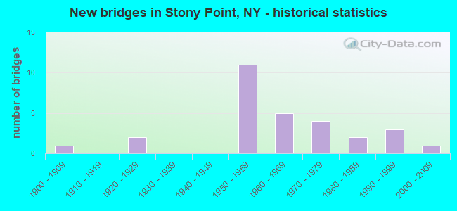
- New bridges - historical statistics
- 11900-1909
- 21920-1929
- 111950-1959
- 51960-1969
- 41970-1979
- 21980-1989
- 31990-1999
- 12000-2009
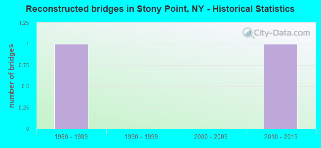
- Reconstructed bridges - Historical Statistics
- 11980-1989
- 01990-1999
- 02000-2009
- 12010-2019
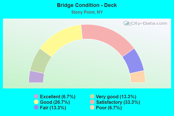
- Bridge Condition - Deck
- 6.7%Excellent
- 13.3%Very good
- 26.7%Good
- 33.3%Satisfactory
- 13.3%Fair
- 6.7%Poor
- Bridge Condition - Superstructure
- 15.8%Very good
- 31.6%Good
- 31.6%Satisfactory
- 15.8%Fair
- 5.3%Poor
- Bridge Condition - Substructure
- 5.3%Excellent
- 31.6%Good
- 31.6%Satisfactory
- 26.3%Fair
- 5.3%Poor
- Bridge Condition - Channel
- 11.1%Very good
- 11.1%Good
- 38.9%Satisfactory
- 33.3%Fair
- 5.6%Poor
- Bridge Condition - Culverts
- 75.0%Satisfactory
- 25.0%Fair
Find on map >> Show street view
Structure Number: 100714, Location: 0.2 MI S JCT RTS 9W & 210 (Lat: 41.228047, Lng: -73.987550), Route carried "on" structure: US 9W, Year Built: 2009, Status: Open, Structure Length: 12.16m (39.90ft), Average Daily Traffic: 11,476 (year 2017), Truck Traffic: 4%, Average Future Daily Traffic: 11,529 (year 2040), Design Load: HL 93, Features Intersected: CEDAR POND BROOK
Minimum Vertical Clearance: 30+ m (98+ ft), Kilometerpoint: 29.445, Lanes on structure: 3, Base Highway Network: Yes, Owner: State Highway Agency, Approaching Roadway Width: 13.1m (43.0ft), Material/Design: Steel continuous, Design/Construction: Stringer/Multi-beam, Number Of Spans In Main Unit: 3, Length of Maximum Span: 50.0m (164.0ft), Curb or Sidewalk Widths: Left: 1.5m (4.9ft), Right: 1.5m (4.9ft), Curb-To-Curb Width: 13.2m (43.3ft), Out-to-Out Width: 17.8m (58.4ft)
Condition: Deck: Very good, Superstructure: Very good, Substructure: Excellent, Channel: Very good, Operating Rating: 95.3 metric tons, Method Used To Determine Operating Rating: Load Factor (LF), Inventory Rating: 56.2 metric tons, Method Used To Determine Inventory Rating: Load Factor (LF), Structural Evaluation: Equal to present desirable criteria, Deck Geometry: Somewhat better than minimum adequacy, Waterway Adequacy: Equal to present minimum criteria, Approach Roadway Alignment: Equal to present desirable criteria, Length Of Structure Improvement: 12.16m (39.90ft), Designated Inspection Frequency: Every 24 months, Inspection Date: September 2021, Bridge Improvement Cost: $8,734,000, Roadway Improvement Cost: $5,115,000, Total Project Cost: $13,849,000 ( Estimate for 2021), Deck Structure Type: Concrete Cast-file-Place, Wearing Surface/Protective System: Wearing Surface: Integral Concrete, Deck Protection: Epoxy Coated Reinforcing
Find on map >> Show street view
Structure Number: 104088, Location: EXIT 15 OF PIP (Lat: 41.235133, Lng: -74.033872), Route carried "on" structure: County highway , Year Built: 1951, Status: Open, Structure Length: 4.24m (13.91ft), Average Daily Traffic: 4,443 (year 2019), Truck Traffic: 8%, Average Future Daily Traffic: 5,497 (year 2040), Design Load: HS 20, Features Intersected: 987C 987C85011176, 987C, Facility Carried by Structure: COUNTY ROAD 106
Minimum Vertical Clearance: 30+ m (98+ ft), Kilometerpoint: 7.771, Lanes on structure: 2, Lanes under structure: 4, Owner: State Highway Agency, Approaching Roadway Width: 10.4m (34.1ft), Skew: 3 degrees, Material/Design: Concrete continuous, Design/Construction: Frame, Number Of Spans In Main Unit: 2, Length of Maximum Span: 19.2m (63.0ft), Curb or Sidewalk Widths: Left: 1.5m (4.9ft), Right: 1.5m (4.9ft), Curb-To-Curb Width: 10.4m (34.1ft), Out-to-Out Width: 14.3m (46.9ft)
Condition: Superstructure: Satisfactory, Substructure: Fair, Operating Rating: 84.9 metric tons, Method Used To Determine Operating Rating: Field evaluation and documented engineering judgment, Inventory Rating: 29.4 metric tons, Method Used To Determine Inventory Rating: Field evaluation and documented engineering judgment, Structural Evaluation: Somewhat better than minimum adequacy, Deck Geometry: Somewhat better than minimum adequacy, Underclear: High priority of corrective action, Approach Roadway Alignment: Meets minimum limits, Length Of Structure Improvement: 4.23m (13.88ft), Designated Inspection Frequency: Every 24 months, Inspection Date: September 2020, Bridge Improvement Cost: $3,148,000, Roadway Improvement Cost: $1,844,000, Total Project Cost: $4,992,000 ( Estimate for 2021), Wearing Surface/Protective System: Wearing Surface: Bituminous
Find on map >> Show street view
Structure Number: 1068769, Location: EXIT 14 - P I P (Lat: 41.220281, Lng: -74.033633), Route carried "on" structure: Other road 987C, Year Built: 1951, Status: Open, Structure Length: 3.60m (11.81ft), Truck Traffic: 2%, Features Intersected: CR98-WLLOW GRV RD, MINIS
Minimum Vertical Clearance: 30+ m (98+ ft), Kilometerpoint: 26.838, Lanes on structure: 4, Lanes under structure: 2, Base Highway Network: Yes, Owner: State Park, Forest, or Reservation Agency, Maintenance Responsibility: State Highway Agency, Approaching Roadway Width: 14.6m (47.9ft), Skew: 20 degrees, Material/Design: Concrete, Design/Construction: Arch - Deck, Number Of Spans In Main Unit: 1, Length of Maximum Span: 24.3m (79.7ft), Curb or Sidewalk Widths: Left: 1.1m (3.6ft), Right: 1.5m (4.9ft), Curb-To-Curb Width: 14.6m (47.9ft), Out-to-Out Width: 29.0m (95.1ft)
Condition: Superstructure: Satisfactory, Substructure: Satisfactory, Channel: Satisfactory, Operating Rating: 63.0 metric tons, Method Used To Determine Operating Rating: Field evaluation and documented engineering judgment, Inventory Rating: 22.0 metric tons, Method Used To Determine Inventory Rating: Field evaluation and documented engineering judgment, Structural Evaluation: Somewhat better than minimum adequacy, Deck Geometry: High priority of replacement, Underclear: Meets minimum limits, Waterway Adequacy: Superior to present desirable criteria, Approach Roadway Alignment: Equal to present desirable criteria, Length Of Structure Improvement: 3.59m (11.78ft), Designated Inspection Frequency: Every 24 months, Inspection Date: September 2020, Bridge Improvement Cost: $10,238,000, Roadway Improvement Cost: $5,995,000, Total Project Cost: $16,234,000 ( Estimate for 2021), Wearing Surface/Protective System: Wearing Surface: Bituminous
Find on map >> Show street view
Structure Number: 106877, Location: EXIT 16 - P I P (Lat: 41.248861, Lng: -74.039289), Route carried "on" structure: Ramp Other road 987A, Year Built: 1951, Status: Open, Structure Length: 2.74m (8.99ft), Average Daily Traffic: 117 (year 2018), Truck Traffic: 15%, Average Future Daily Traffic: 165 (year 2040), Design Load: H 20, Features Intersected: RTE 987C
Minimum Vertical Clearance: 30+ m (98+ ft), Kilometerpoint: 0.241, Lanes on structure: 1, Lanes under structure: 2, Owner: State Park, Forest, or Reservation Agency, Maintenance Responsibility: State Highway Agency, Approaching Roadway Width: 5.5m (18.0ft), Skew: 4 degrees, Material/Design: Concrete, Design/Construction: Frame, Number Of Spans In Main Unit: 1, Length of Maximum Span: 22.5m (73.8ft), Curb or Sidewalk Widths: Left: 3.4m (11.2ft), Right: 3.4m (11.2ft), Curb-To-Curb Width: 5.5m (18.0ft), Out-to-Out Width: 13.1m (43.0ft)
Condition: Deck: Fair, Superstructure: Fair, Substructure: Fair, Operating Rating: 61.8 metric tons, Method Used To Determine Operating Rating: Field evaluation and documented engineering judgment, Inventory Rating: 23.8 metric tons, Method Used To Determine Inventory Rating: Field evaluation and documented engineering judgment, Structural Evaluation: Somewhat better than minimum adequacy, Deck Geometry: Meets minimum limits, Underclear: High priority of corrective action, Approach Roadway Alignment: Meets minimum limits, Length Of Structure Improvement: 2.74m (8.99ft), Designated Inspection Frequency: Every 24 months, Inspection Date: May 2020, Bridge Improvement Cost: $3,173,000, Roadway Improvement Cost: $1,858,000, Total Project Cost: $5,031,000 ( Estimate for 2021), Wearing Surface/Protective System: Wearing Surface: Bituminous
Find on map >> Show street view
Structure Number: 106887, Location: .8 MI N JCT PIP & SH 210 (Lat: 41.245725, Lng: -74.030411), Route carried "on" structure: Other road 987C, Year Built: 1951, Status: Open, Structure Length: 1.34m (4.40ft), Average Daily Traffic: 26,417 (year 2011), Truck Traffic: 2%, Average Future Daily Traffic: 37,266 (year 2040), Design Load: H 20, Features Intersected: LAKE TIORATI BRK
Minimum Vertical Clearance: 30+ m (98+ ft), Kilometerpoint: 29.927, Lanes on structure: 2, Base Highway Network: Yes, Owner: State Park, Forest, or Reservation Agency, Maintenance Responsibility: State Highway Agency, Approaching Roadway Width: 7.3m (24.0ft), Skew: 5 degrees, Material/Design: Concrete, Design/Construction: Arch - Deck, Number Of Spans In Main Unit: 1, Length of Maximum Span: 9.1m (29.9ft), Curb-To-Curb Width: 7.3m (24.0ft), Out-to-Out Width: 38.2m (125.3ft)
Condition: Superstructure: Satisfactory, Substructure: Fair, Channel: Satisfactory, Operating Rating: 64.4 metric tons, Method Used To Determine Operating Rating: Field evaluation and documented engineering judgment, Inventory Rating: 17.1 metric tons, Method Used To Determine Inventory Rating: Field evaluation and documented engineering judgment, Structural Evaluation: Meets minimum limits, Deck Geometry: High priority of replacement, Waterway Adequacy: Superior to present desirable criteria, Approach Roadway Alignment: Equal to present desirable criteria, Length Of Structure Improvement: 1.34m (4.40ft), Designated Inspection Frequency: Every 24 months, Inspection Date: July 2020, Bridge Improvement Cost: $1,758,000, Roadway Improvement Cost: $1,030,000, Total Project Cost: $2,788,000 ( Estimate for 2021), Wearing Surface/Protective System: Wearing Surface: Bituminous
Find on map >> Show street view
Structure Number: 106888, Location: 1.3 MI N JCT PIP+RTE 210 (Lat: 41.249006, Lng: -74.038511), Route carried "on" structure: Other road 987C, Year Built: 1951, Status: Open, Structure Length: 1.43m (4.69ft), Average Daily Traffic: 117 (year 2018), Truck Traffic: 15%, Average Future Daily Traffic: 165 (year 2040), Design Load: H 20, Features Intersected: LAKE TIORATI BRK
Minimum Vertical Clearance: 30+ m (98+ ft), Kilometerpoint: 0.193, Lanes on structure: 1, Owner: State Park, Forest, or Reservation Agency, Maintenance Responsibility: State Highway Agency, Approaching Roadway Width: 6.1m (20.0ft), Skew: 3 degrees, Material/Design: Concrete, Design/Construction: Arch - Deck, Number Of Spans In Main Unit: 1, Length of Maximum Span: 9.1m (29.9ft), Curb-To-Curb Width: 9.6m (31.5ft), Out-to-Out Width: 35.4m (116.1ft)
Condition: Superstructure: Satisfactory, Substructure: Poor, Channel: Poor, Operating Rating: 64.4 metric tons, Method Used To Determine Operating Rating: Field evaluation and documented engineering judgment, Inventory Rating: 17.1 metric tons, Method Used To Determine Inventory Rating: Field evaluation and documented engineering judgment, Structural Evaluation: Meets minimum limits, Deck Geometry: Equal to present minimum criteria, Waterway Adequacy: High priority of corrective action, Approach Roadway Alignment: Equal to present desirable criteria, Length Of Structure Improvement: 1.43m (4.69ft), Designated Inspection Frequency: Every 24 months, Inspection Date: July 2020, Bridge Improvement Cost: $1,743,000, Roadway Improvement Cost: $1,021,000, Total Project Cost: $2,764,000 ( Estimate for 2021)
Find on map >> Show street view
Structure Number: 106889, Location: 1.4 MI N JCT PIP+RTE 210 (Lat: 41.249811, Lng: -74.041506), Route carried "on" structure: Other road 987C, Year Built: 1950, Status: Open, Structure Length: 0.98m (3.22ft), Truck Traffic: 2%, Design Load: H 20, Features Intersected: LAKE TIORATI BRK
Minimum Vertical Clearance: 30+ m (98+ ft), Kilometerpoint: 30.957, Lanes on structure: 2, Base Highway Network: Yes, Owner: State Park, Forest, or Reservation Agency, Maintenance Responsibility: State Highway Agency, Approaching Roadway Width: 7.3m (24.0ft), Material/Design: Concrete, Design/Construction: Frame, Number Of Spans In Main Unit: 1, Length of Maximum Span: 8.5m (27.9ft), Curb-To-Curb Width: 7.6m (24.9ft), Out-to-Out Width: 14.5m (47.6ft)
Condition: Deck: Satisfactory, Superstructure: Satisfactory, Substructure: Satisfactory, Channel: Satisfactory, Operating Rating: 68.1 metric tons, Method Used To Determine Operating Rating: Field evaluation and documented engineering judgment, Inventory Rating: 29.4 metric tons, Method Used To Determine Inventory Rating: Field evaluation and documented engineering judgment, Structural Evaluation: Equal to present minimum criteria, Deck Geometry: High priority of replacement, Waterway Adequacy: Meets minimum limits, Approach Roadway Alignment: Meets minimum limits, Length Of Structure Improvement: 0.97m (3.18ft), Designated Inspection Frequency: Every 24 months, Inspection Date: September 2020, Bridge Improvement Cost: $895,000, Roadway Improvement Cost: $524,000, Total Project Cost: $1,419,000 ( Estimate for 2021)
Find on map >> Show street view
Structure Number: 106895, Location: 2.4 MI N JCT PIP+RTE 202 (Lat: 41.219117, Lng: -74.032461), Route carried "on" structure: Ramp Other road 987C, Year Built: 1951, Status: Open, Structure Length: 0.94m (3.08ft), Average Daily Traffic: 907 (year 2020), Truck Traffic: 1%, Average Future Daily Traffic: 1,279 (year 2040), Design Load: H 20, Features Intersected: MINISCEONGO CREEK
Minimum Vertical Clearance: 30+ m (98+ ft), Kilometerpoint: 0.113, Lanes on structure: 2, Owner: State Park, Forest, or Reservation Agency, Maintenance Responsibility: State Highway Agency, Approaching Roadway Width: 7.3m (24.0ft), Skew: 4 degrees, Material/Design: Concrete, Design/Construction: Frame, Number Of Spans In Main Unit: 1, Length of Maximum Span: 9.4m (30.8ft), Curb or Sidewalk Widths: Left: 1.1m (3.6ft), Right: 1.5m (4.9ft), Curb-To-Curb Width: 7.3m (24.0ft), Out-to-Out Width: 10.9m (35.8ft)
Condition: Deck: Fair, Superstructure: Fair, Substructure: Satisfactory, Channel: Satisfactory, Operating Rating: 65.8 metric tons, Method Used To Determine Operating Rating: Field evaluation and documented engineering judgment, Inventory Rating: 28.1 metric tons, Method Used To Determine Inventory Rating: Field evaluation and documented engineering judgment, Structural Evaluation: Somewhat better than minimum adequacy, Deck Geometry: High priority of replacement, Waterway Adequacy: Meets minimum limits, Approach Roadway Alignment: Somewhat better than minimum adequacy, Length Of Structure Improvement: 0.94m (3.08ft), Designated Inspection Frequency: Every 24 months, Inspection Date: October 2020, Bridge Improvement Cost: $827,000, Roadway Improvement Cost: $485,000, Total Project Cost: $1,312,000 ( Estimate for 2021)
Find on map >> Show street view
Structure Number: 109152, Location: 1.5 MI E JCT RTE 210+PIP (Lat: 41.234803, Lng: -74.009458), Route carried "on" structure: County highway , Year Built: 1970, Status: Open, Structure Length: 1.58m (5.18ft), Average Daily Traffic: 7,966 (year 2020), Average Future Daily Traffic: 9,856 (year 2040), Design Load: HS 20, Features Intersected: CEDAR POND BROOK, Facility Carried by Structure: COUNTY ROAD 106
Minimum Vertical Clearance: 30+ m (98+ ft), Kilometerpoint: 10.056, Lanes on structure: 4, Owner: County Highway Agency, Approaching Roadway Width: 21.9m (71.9ft), Skew: 4 degrees, Material/Design: Concrete continuous, Design/Construction: Culvert, Number Of Spans In Main Unit: 2, Length of Maximum Span: 5.8m (19.0ft)
Condition: Channel: Fair, Culverts: Satisfactory, Inventory Rating: 74.4 metric tons, Method Used To Determine Inventory Rating: Load Factor (LF), Structural Evaluation: Equal to present minimum criteria, Waterway Adequacy: Meets minimum limits, Approach Roadway Alignment: Equal to present desirable criteria, Length Of Structure Improvement: 1.58m (5.18ft), Designated Inspection Frequency: Every 24 months, Inspection Date: December 2020, Bridge Improvement Cost: $1,194,000, Roadway Improvement Cost: $699,000, Total Project Cost: $1,893,000 ( Estimate for 2021)
Find on map >> Show street view
Structure Number: 109153, Location: 0.7 MI E JCT RTE 210+PIP (Lat: 41.237711, Lng: -74.022094), Route carried "on" structure: County highway , Year Built: 1970, Status: Open, Structure Length: 1.58m (5.18ft), Average Daily Traffic: 4,443 (year 2019), Truck Traffic: 8%, Average Future Daily Traffic: 5,497 (year 2040), Design Load: HS 20, Features Intersected: CEDAR POND BROOK, Facility Carried by Structure: COUNTY ROAD 210
Minimum Vertical Clearance: 30+ m (98+ ft), Kilometerpoint: 9.010, Lanes on structure: 3, Owner: County Highway Agency, Approaching Roadway Width: 18.3m (60.0ft), Skew: 4 degrees, Material/Design: Concrete continuous, Design/Construction: Culvert, Number Of Spans In Main Unit: 2, Length of Maximum Span: 7.0m (23.0ft), Curb-To-Curb Width: 18.3m (60.0ft), Out-to-Out Width: 19.1m (62.7ft)
Condition: Channel: Fair, Culverts: Satisfactory, Operating Rating: 98.0 metric tons, Method Used To Determine Operating Rating: Allowable Stress (AS), Inventory Rating: 50.8 metric tons, Method Used To Determine Inventory Rating: Allowable Stress (AS), Structural Evaluation: Equal to present minimum criteria, Deck Geometry: Superior to present desirable criteria, Waterway Adequacy: Superior to present desirable criteria, Approach Roadway Alignment: Equal to present desirable criteria, Length Of Structure Improvement: 1.58m (5.18ft), Designated Inspection Frequency: Every 24 months, Inspection Date: June 2020, Bridge Improvement Cost: $2,061,000, Roadway Improvement Cost: $1,207,000, Total Project Cost: $3,268,000 ( Estimate for 2021), Deck Structure Type: Concrete Cast-file-Place, Wearing Surface/Protective System: Wearing Surface: Bituminous
Find on map >> Show street view
Structure Number: 236478, Location: 2.7 MI NW W HAVERSTRAW (Lat: 41.219861, Lng: -74.035897), Route carried "on" structure: Other road , Year Built: 1999, Status: Open, Structure Length: 1.04m (3.41ft), Truck Traffic: 4%, Features Intersected: MINISCEONGO CREEK, Facility Carried by Structure: WILLOW GROVE ROAD
Minimum Vertical Clearance: 30+ m (98+ ft), Kilometerpoint: 0.016, Lanes on structure: 2, Owner: State Agenciy, Maintenance Responsibility: Town or Township Highway Agency, Approaching Roadway Width: 5.2m (17.1ft), Skew: 1 degrees, Material/Design: Steel, Design/Construction: Stringer/Multi-beam, Number Of Spans In Main Unit: 1, Length of Maximum Span: 8.8m (28.9ft), Curb-To-Curb Width: 6.4m (21.0ft), Out-to-Out Width: 6.6m (21.7ft)
Condition: Deck: Good, Superstructure: Good, Substructure: Good, Channel: Satisfactory, Operating Rating: 60.8 metric tons, Method Used To Determine Operating Rating: Allowable Stress (AS), Inventory Rating: 45.4 metric tons, Method Used To Determine Inventory Rating: Allowable Stress (AS), Structural Evaluation: Better than present minimum criteria, Deck Geometry: Somewhat better than minimum adequacy, Waterway Adequacy: Superior to present desirable criteria, Approach Roadway Alignment: Somewhat better than minimum adequacy, Length Of Structure Improvement: 1.03m (3.38ft), Designated Inspection Frequency: Every 24 months, Inspection Date: May 2020, Bridge Improvement Cost: $635,000, Roadway Improvement Cost: $372,000, Total Project Cost: $1,007,000 ( Estimate for 2021), Deck Structure Type: Wood or Timber, Wearing Surface/Protective System: Wearing Surface: Bituminous, Membrane: Other
Find on map >> Show street view
Structure Number: 334584, Location: 1.7 MI W JCT CR 106 & PIP (Lat: 41.230072, Lng: -74.061064), Route carried "on" structure: County highway , Year Built: 1992, Status: Open, Structure Length: 1.25m (4.10ft), Average Daily Traffic: 788 (year 2019), Truck Traffic: 5%, Average Future Daily Traffic: 957 (year 2040), Design Load: HS 20, Features Intersected: MINISCEONGO CREEK, Facility Carried by Structure: COUNTY ROAD 106
Minimum Vertical Clearance: 30+ m (98+ ft), Kilometerpoint: 5.068, Lanes on structure: 2, Owner: County Highway Agency, Approaching Roadway Width: 9.1m (29.9ft), Skew: 4 degrees, Material/Design: Prestressed concrete, Design/Construction: Box Beam or Girders - Multiple, Number Of Spans In Main Unit: 1, Length of Maximum Span: 11.6m (38.1ft), Curb-To-Curb Width: 9.1m (29.9ft), Out-to-Out Width: 10.1m (33.1ft)
Condition: Deck: Good, Superstructure: Good, Substructure: Good, Channel: Good, Operating Rating: 69.9 metric tons, Method Used To Determine Operating Rating: Allowable Stress (AS), Inventory Rating: 32.7 metric tons, Method Used To Determine Inventory Rating: Allowable Stress (AS), Structural Evaluation: Better than present minimum criteria, Deck Geometry: Equal to present minimum criteria, Waterway Adequacy: Somewhat better than minimum adequacy, Approach Roadway Alignment: Equal to present desirable criteria, Length Of Structure Improvement: 1.24m (4.07ft), Designated Inspection Frequency: Every 24 months, Inspection Date: May 2021, Bridge Improvement Cost: $500,000, Roadway Improvement Cost: $293,000, Total Project Cost: $792,000 ( Estimate for 2021), Wearing Surface/Protective System: Wearing Surface: Integral Concrete
Find on map >> Show street view
Structure Number: 33459, Location: 3.4 MI SW OF STONY POINT (Lat: 41.219567, Lng: -74.044206), Route carried "on" structure: Other road , Year Built: 1989, Status: Open, Structure Length: 0.82m (2.69ft), Average Daily Traffic: 1,575 (year 2019), Truck Traffic: 5%, Average Future Daily Traffic: 1,913 (year 2040), Design Load: HS 20, Features Intersected: MINISCEONGO CREEK, Facility Carried by Structure: CALLS HOLLOW ROAD
Minimum Vertical Clearance: 30+ m (98+ ft), Kilometerpoint: 4.425, Lanes on structure: 2, Owner: County Highway Agency, Approaching Roadway Width: 9.1m (29.9ft), Skew: 6 degrees, Material/Design: Concrete, Design/Construction: Culvert, Number Of Spans In Main Unit: 2, Length of Maximum Span: 3.9m (12.8ft), Curb or Sidewalk Widths: Left: 1.4m (4.6ft), Right: 0.0m
Condition: Channel: Fair, Culverts: Fair, Operating Rating: 74.4 metric tons, Method Used To Determine Operating Rating: Load Factor (LF), Inventory Rating: 44.5 metric tons, Method Used To Determine Inventory Rating: Load Factor (LF), Structural Evaluation: Somewhat better than minimum adequacy, Waterway Adequacy: Meets minimum limits, Approach Roadway Alignment: Equal to present desirable criteria, Length Of Structure Improvement: 0.82m (2.69ft), Designated Inspection Frequency: Every 24 months, Inspection Date: May 2021, Bridge Improvement Cost: $589,000, Roadway Improvement Cost: $345,000, Total Project Cost: $933,000 ( Estimate for 2021)
Find on map >> Show street view
Structure Number: 334627, Location: 1.0 MI W OF STONY POINT (Lat: 41.233444, Lng: -74.002919), Route carried "on" structure: Other road , Year Built: 1926, Year Reconstructed: 1994, Status: Open, Structure Length: 1.58m (5.18ft), Average Daily Traffic: 2,051 (year 2019), Truck Traffic: 4%, Average Future Daily Traffic: 2,537 (year 2040), Design Load: HS 25 or greater, Features Intersected: CEDAR POND BROOK, Facility Carried by Structure: RESERVOIR ROAD
Minimum Vertical Clearance: 30+ m (98+ ft), Kilometerpoint: 0.290, Lanes on structure: 2, Owner: County Highway Agency, Approaching Roadway Width: 7.6m (24.9ft), Skew: 1 degrees, Material/Design: Steel, Design/Construction: Stringer/Multi-beam, Number Of Spans In Main Unit: 1, Length of Maximum Span: 15.2m (49.9ft), Curb or Sidewalk Widths: Left: 0.0m, Right: 1.5m (4.9ft), Curb-To-Curb Width: 7.9m (25.9ft), Out-to-Out Width: 9.8m (32.2ft)
Condition: Deck: Very good, Superstructure: Very good, Substructure: Satisfactory, Channel: Satisfactory, Inventory Rating: 62.6 metric tons, Method Used To Determine Inventory Rating: Allowable Stress (AS), Structural Evaluation: Equal to present minimum criteria, Deck Geometry: High priority of corrective action, Waterway Adequacy: Superior to present desirable criteria, Approach Roadway Alignment: Better than present minimum criteria, Length Of Structure Improvement: 1.58m (5.18ft), Designated Inspection Frequency: Every 24 months, Inspection Date: October 2020, Bridge Improvement Cost: $1,504,000, Roadway Improvement Cost: $881,000, Total Project Cost: $2,385,000 ( Estimate for 2021), Deck Structure Type: Concrete Cast-file-Place, Wearing Surface/Protective System: Wearing Surface: Integral Concrete, Deck Protection: Epoxy Coated Reinforcing
Find on map >> Show street view
Structure Number: 334629, Location: 0.3 MI S OF STONY POINT (Lat: 41.226608, Lng: -73.983961), Route carried "on" structure: Other road , Year Built: 1977, Status: Open, Structure Length: 2.38m (7.81ft), Average Daily Traffic: 144 (year 2018), Truck Traffic: 2%, Average Future Daily Traffic: 202 (year 2038), Features Intersected: CEDAR POND BROOK, Facility Carried by Structure: LOWLAND HILL ROAD
Minimum Vertical Clearance: 30+ m (98+ ft), Kilometerpoint: 0.354, Lanes on structure: 2, Owner: County Highway Agency, Approaching Roadway Width: 9.8m (32.2ft), Skew: 2 degrees, Material/Design: Steel, Design/Construction: Stringer/Multi-beam, Number Of Spans In Main Unit: 1, Length of Maximum Span: 22.2m (72.8ft), Curb or Sidewalk Widths: Left: 1.5m (4.9ft), Right: 0.5m (1.6ft), Curb-To-Curb Width: 9.8m (32.2ft), Out-to-Out Width: 11.8m (38.7ft)
Condition: Deck: Satisfactory, Superstructure: Very good, Substructure: Good, Channel: Fair, Operating Rating: 71.0 metric tons, Method Used To Determine Operating Rating: Load and Resistance Factor Rating (LRFR) rating reported by rating factor(RF) method using HL-93 loadings, Inventory Rating: 54.8 metric tons, Method Used To Determine Inventory Rating: Load and Resistance Factor Rating (LRFR) rating reported by rating factor(RF) method using HL-93 loadings, Structural Evaluation: Better than present minimum criteria, Deck Geometry: Better than present minimum criteria, Waterway Adequacy: Meets minimum limits, Approach Roadway Alignment: Somewhat better than minimum adequacy, Length Of Structure Improvement: 2.37m (7.78ft), Designated Inspection Frequency: Every 24 months, Inspection Date: June 2021, Bridge Improvement Cost: $1,708,000, Roadway Improvement Cost: $1,000,000, Total Project Cost: $2,708,000 ( Estimate for 2021), Deck Structure Type: Concrete Cast-file-Place, Wearing Surface/Protective System: Wearing Surface: Bituminous
Find on map >> Show street view
Structure Number: 33463, Location: 1.0 MI NE OF W HAVERSTRAW (Lat: 41.214186, Lng: -73.967072), Route carried "on" structure: County highway , Year Built: 1928, Status: Posted for load, Structure Length: 1.86m (6.10ft), Average Daily Traffic: 2,075 (year 2019), Truck Traffic: 3%, Average Future Daily Traffic: 2,520 (year 2040), Features Intersected: MINISCEONGO CREEK, Facility Carried by Structure: GRASSY POINT ROAD
Minimum Vertical Clearance: 30+ m (98+ ft), Kilometerpoint: 0.853, Lanes on structure: 2, Owner: County Highway Agency, Approaching Roadway Width: 7.3m (24.0ft), Material/Design: Steel, Design/Construction: Stringer/Multi-beam, Number Of Spans In Main Unit: 1, Length of Maximum Span: 17.3m (56.8ft), Curb or Sidewalk Widths: Left: 1.2m (3.9ft), Right: 0.0m, Curb-To-Curb Width: 8.3m (27.2ft), Out-to-Out Width: 10.5m (34.4ft)
Condition: Deck: Poor, Superstructure: Poor, Substructure: Fair, Channel: Fair, Operating Rating: 30.8 metric tons, Method Used To Determine Operating Rating: Load Factor (LF), Inventory Rating: 18.1 metric tons, Method Used To Determine Inventory Rating: Load Factor (LF), Structural Evaluation: Meets minimum limits, Deck Geometry: High priority of corrective action, Waterway Adequacy: Meets minimum limits, Approach Roadway Alignment: Somewhat better than minimum adequacy, Bridge Posting: Required (Relationship of Operating Rating to Maximum Legal Load: > 39.9% below), Length Of Structure Improvement: 1.85m (6.07ft), Designated Inspection Frequency: Every 12 months, Inspection Date: March 2021, Bridge Improvement Cost: $886,000, Roadway Improvement Cost: $519,000, Total Project Cost: $1,405,000 ( Estimate for 2021), Deck Structure Type: Concrete Cast-file-Place, Wearing Surface/Protective System: Wearing Surface: Bituminous
Find on map >> Show street view
Structure Number: 334633, Location: 0.5 MI SE OF STONY POINT (Lat: 41.226364, Lng: -73.973997), Route carried "on" structure: County highway , Year Built: 1953, Status: Open, Structure Length: 3.14m (10.30ft), Average Daily Traffic: 2,075 (year 2019), Truck Traffic: 3%, Average Future Daily Traffic: 2,520 (year 2040), Features Intersected: MINISCEONGO CREEK, Facility Carried by Structure: E MAIN STREET
Minimum Vertical Clearance: 30+ m (98+ ft), Kilometerpoint: 3.138, Lanes on structure: 2, Owner: County Highway Agency, Approaching Roadway Width: 7.3m (24.0ft), Material/Design: Steel, Design/Construction: Stringer/Multi-beam, Number Of Spans In Main Unit: 1, Length of Maximum Span: 30.4m (99.7ft), Curb or Sidewalk Widths: Left: 1.1m (3.6ft), Right: 1.1m (3.6ft), Curb-To-Curb Width: 7.3m (24.0ft), Out-to-Out Width: 9.4m (30.8ft)
Condition: Deck: Satisfactory, Superstructure: Good, Substructure: Fair, Channel: Satisfactory, Operating Rating: 43.7 metric tons, Method Used To Determine Operating Rating: Load and Resistance Factor Rating (LRFR) rating reported by rating factor(RF) method using HL-93 loadings, Inventory Rating: 33.7 metric tons, Method Used To Determine Inventory Rating: Load and Resistance Factor Rating (LRFR) rating reported by rating factor(RF) method using HL-93 loadings, Structural Evaluation: Somewhat better than minimum adequacy, Deck Geometry: High priority of replacement, Waterway Adequacy: Somewhat better than minimum adequacy, Approach Roadway Alignment: Better than present minimum criteria, Length Of Structure Improvement: 3.13m (10.27ft), Designated Inspection Frequency: Every 24 months, Underwater Inspection Frequency: Every 60 months, Inspection Date: July 2021, Underwater Inspection Date: September 2019, Bridge Improvement Cost: $1,444,000, Roadway Improvement Cost: $846,000, Total Project Cost: $2,289,000 ( Estimate for 2021), Deck Structure Type: Concrete Cast-file-Place, Wearing Surface/Protective System: Wearing Surface: Bituminous
Find on map >> Show street view
Structure Number: 334634, Location: 0.2 MI SE OF STONY POINT (Lat: 41.228178, Lng: -73.976639), Route carried "on" structure: Business Other road , Year Built: 1991, Status: Open, Structure Length: 3.84m (12.60ft), Average Daily Traffic: 1,766 (year 2011), Truck Traffic: 4%, Average Future Daily Traffic: 2,185 (year 2040), Design Load: HS 25 or greater, Features Intersected: CSXT RIVER LINE, Facility Carried by Structure: EAST MAIN STREET
Minimum Vertical Clearance: 30+ m (98+ ft), Kilometerpoint: 3.443, Lanes on structure: 2, Owner: County Highway Agency, Approaching Roadway Width: 7.9m (25.9ft), Skew: 2 degrees, Material/Design: Prestressed concrete, Design/Construction: Box Beam or Girders - Multiple, Number Of Spans In Main Unit: 3, Length of Maximum Span: 17.9m (58.7ft), Curb or Sidewalk Widths: Left: 0.0m, Right: 1.5m (4.9ft), Curb-To-Curb Width: 7.9m (25.9ft), Out-to-Out Width: 10.2m (33.5ft)
Condition: Deck: Satisfactory, Superstructure: Good, Substructure: Good, Operating Rating: 99.8 metric tons, Method Used To Determine Operating Rating: Allowable Stress (AS), Inventory Rating: 40.8 metric tons, Method Used To Determine Inventory Rating: Allowable Stress (AS), Structural Evaluation: Better than present minimum criteria, Deck Geometry: Meets minimum limits, Underclear: High priority of corrective action, Approach Roadway Alignment: Equal to present desirable criteria, Length Of Structure Improvement: 3.84m (12.60ft), Designated Inspection Frequency: Every 24 months, Inspection Date: June 2020, Bridge Improvement Cost: $1,176,000, Roadway Improvement Cost: $689,000, Total Project Cost: $1,865,000 ( Estimate for 2021), Deck Structure Type: Concrete Cast-file-Place, Wearing Surface/Protective System: Wearing Surface: Integral Concrete, Deck Protection: Epoxy Coated Reinforcing
Find on map >> Show street view
Structure Number: 509154, Location: LAKE WELCH PKWY-HARRIMAN (Lat: 41.231525, Lng: -74.089050), Route carried "on" structure: Other road 987A, Year Built: 1967, Status: Open, Structure Length: 1.74m (5.71ft), Average Daily Traffic: 191 (year 2018), Truck Traffic: 6%, Average Future Daily Traffic: 232 (year 2040), Features Intersected: COUNTY ROAD 106
Minimum Vertical Clearance: 30+ m (98+ ft), Kilometerpoint: 3.636, Lanes on structure: 2, Lanes under structure: 2, Base Highway Network: Yes, Owner: State Park, Forest, or Reservation Agency, Approaching Roadway Width: 12.5m (41.0ft), Skew: 1 degrees, Material/Design: Concrete, Design/Construction: Frame, Number Of Spans In Main Unit: 1, Length of Maximum Span: 15.5m (50.9ft), Curb-To-Curb Width: 12.6m (41.3ft), Out-to-Out Width: 14.4m (47.2ft)
Condition: Deck: Satisfactory, Superstructure: Satisfactory, Substructure: Good, Operating Rating: 83.6 metric tons, Method Used To Determine Operating Rating: Field evaluation and documented engineering judgment, Inventory Rating: 32.7 metric tons, Method Used To Determine Inventory Rating: Field evaluation and documented engineering judgment, Structural Evaluation: Equal to present minimum criteria, Deck Geometry: Superior to present desirable criteria, Underclear: Equal to present minimum criteria, Approach Roadway Alignment: Equal to present desirable criteria, Length Of Structure Improvement: 1.73m (5.68ft), Designated Inspection Frequency: Every 24 months, Inspection Date: September 2020, Bridge Improvement Cost: $1,925,000, Roadway Improvement Cost: $1,127,000, Total Project Cost: $3,052,000 ( Estimate for 2021), Wearing Surface/Protective System: Wearing Surface: Integral Concrete
Find on map >> Show street view
Structure Number: 5521481, Location: 4.6 MI NW OF W HAVERSTRAW (Lat: 41.250639, Lng: -74.049175), Route carried "on" structure: Other road 987A, Year Built: 1967, Status: Open, Structure Length: 9.08m (29.79ft), Average Daily Traffic: 46 (year 2015), Truck Traffic: 4%, Average Future Daily Traffic: 55 (year 2040), Design Load: H 20, Features Intersected: TIORATI BROOK, TIORATI B
Minimum Vertical Clearance: 30+ m (98+ ft), Kilometerpoint: 7.997, Lanes on structure: 1, Lanes under structure: 1, Base Highway Network: Yes, Owner: State Park, Forest, or Reservation Agency, Approaching Roadway Width: 7.9m (25.9ft), Skew: 6 degrees, Material/Design: Steel, Design/Construction: Stringer/Multi-beam, Number Of Spans In Main Unit: 3, Length of Maximum Span: 39.9m (130.9ft), Curb or Sidewalk Widths: Left: 0.5m (1.6ft), Right: 0.0m, Curb-To-Curb Width: 8.8m (28.9ft), Out-to-Out Width: 10.1m (33.1ft)
Condition: Deck: Good, Superstructure: Good, Substructure: Good, Channel: Very good, Operating Rating: 90.7 metric tons, Method Used To Determine Operating Rating: Load Factor (LF), Inventory Rating: 53.5 metric tons, Method Used To Determine Inventory Rating: Load Factor (LF), Structural Evaluation: Better than present minimum criteria, Deck Geometry: Better than present minimum criteria, Underclear: Equal to present minimum criteria, Waterway Adequacy: Superior to present desirable criteria, Approach Roadway Alignment: Equal to present desirable criteria, Length Of Structure Improvement: 9.08m (29.79ft), Designated Inspection Frequency: Every 24 months, Inspection Date: September 2021, Bridge Improvement Cost: $5,312,000, Roadway Improvement Cost: $3,111,000, Total Project Cost: $8,423,000 ( Estimate for 2021), Deck Structure Type: Concrete Cast-file-Place, Wearing Surface/Protective System: Wearing Surface: Integral Concrete
Find on map >> Show street view
Structure Number: 5521482, Location: 4.6 MI NW OF W.HAVERSTRAW (Lat: 41.250364, Lng: -74.048403), Route carried "on" structure: Other road 987A, Year Built: 1970, Status: Open, Structure Length: 2.44m (8.01ft), Average Daily Traffic: 46 (year 2015), Truck Traffic: 4%, Average Future Daily Traffic: 55 (year 2040), Features Intersected: TIORATI BROOK
Minimum Vertical Clearance: 30+ m (98+ ft), Kilometerpoint: 8.045, Lanes on structure: 1, Base Highway Network: Yes, Owner: State Park, Forest, or Reservation Agency, Approaching Roadway Width: 8.8m (28.9ft), Skew: 3 degrees, Material/Design: Steel, Design/Construction: Stringer/Multi-beam, Number Of Spans In Main Unit: 1, Length of Maximum Span: 22.8m (74.8ft), Curb-To-Curb Width: 8.8m (28.9ft), Out-to-Out Width: 10.1m (33.1ft)
Condition: Deck: Good, Superstructure: Good, Substructure: Satisfactory, Channel: Good, Operating Rating: 84.9 metric tons, Method Used To Determine Operating Rating: Load and Resistance Factor Rating (LRFR) rating reported by rating factor(RF) method using HL-93 loadings, Inventory Rating: 65.4 metric tons, Method Used To Determine Inventory Rating: Load and Resistance Factor Rating (LRFR) rating reported by rating factor(RF) method using HL-93 loadings, Structural Evaluation: Equal to present minimum criteria, Deck Geometry: Better than present minimum criteria, Waterway Adequacy: Equal to present minimum criteria, Approach Roadway Alignment: Equal to present desirable criteria, Length Of Structure Improvement: 2.43m (7.97ft), Designated Inspection Frequency: Every 24 months, Inspection Date: November 2020, Bridge Improvement Cost: $1,765,000, Roadway Improvement Cost: $1,033,000, Total Project Cost: $2,798,000 ( Estimate for 2021), Deck Structure Type: Concrete Cast-file-Place, Wearing Surface/Protective System: Wearing Surface: Integral Concrete
Find on map >> Show street view
Structure Number: 552149, Location: 4.1 MI N OF MOUNT IVY (Lat: 41.249258, Lng: -74.042072), Route carried "on" structure: Other road 987A, Year Built: 1967, Status: Open, Structure Length: 1.83m (6.00ft), Average Daily Traffic: 91 (year 2015), Truck Traffic: 4%, Average Future Daily Traffic: 110 (year 2040), Features Intersected: TIORATI BROOK
Minimum Vertical Clearance: 30+ m (98+ ft), Kilometerpoint: 8.592, Lanes on structure: 2, Base Highway Network: Yes, Owner: State Park, Forest, or Reservation Agency, Approaching Roadway Width: 7.3m (24.0ft), Skew: 3 degrees, Material/Design: Concrete continuous, Design/Construction: Culvert, Number Of Spans In Main Unit: 2, Length of Maximum Span: 5.4m (17.7ft), Curb or Sidewalk Widths: Left: 2.7m (8.9ft), Right: 2.6m (8.5ft), Curb-To-Curb Width: 7.3m (24.0ft), Out-to-Out Width: 14.9m (48.9ft)
Condition: Channel: Fair, Culverts: Satisfactory, Operating Rating: 70.8 metric tons, Method Used To Determine Operating Rating: Allowable Stress (AS), Inventory Rating: 34.5 metric tons, Method Used To Determine Inventory Rating: Allowable Stress (AS), Structural Evaluation: Equal to present minimum criteria, Deck Geometry: Equal to present minimum criteria, Waterway Adequacy: Meets minimum limits, Approach Roadway Alignment: Equal to present desirable criteria, Length Of Structure Improvement: 1.82m (5.97ft), Designated Inspection Frequency: Every 24 months, Inspection Date: July 2021, Bridge Improvement Cost: $1,428,000, Roadway Improvement Cost: $836,000, Total Project Cost: $2,263,000 ( Estimate for 2021)
Find on map >> Show street view
Structure Number: 734632, Location: .8 MILE N OF STONY POINT (Lat: 41.241064, Lng: -73.976639), Route carried "on" structure: Other road , Year Built: 1985, Year Reconstructed: 2018, Status: Open, Structure Length: 1.92m (6.30ft), Truck Traffic: 4%, Features Intersected: CSX TRANS/ RVR LN, Facility Carried by Structure: STONY PT PARK RD
Minimum Vertical Clearance: 30+ m (98+ ft), Kilometerpoint: 0.692, Lanes on structure: 1, Owner: State Park, Forest, or Reservation Agency, Approaching Roadway Width: 3.0m (9.8ft), Material/Design: Steel, Design/Construction: Girder and Floorbeam System, Number Of Spans In Main Unit: 1, Length of Maximum Span: 18.8m (61.7ft), Curb-To-Curb Width: 3.1m (10.2ft), Out-to-Out Width: 4.0m (13.1ft)
Condition: Deck: Excellent, Superstructure: Fair, Substructure: Satisfactory, Operating Rating: 84.4 metric tons, Method Used To Determine Operating Rating: Load Factor (LF), Inventory Rating: 50.8 metric tons, Method Used To Determine Inventory Rating: Load Factor (LF), Structural Evaluation: Somewhat better than minimum adequacy, Deck Geometry: High priority of replacement, Underclear: Meets minimum limits, Approach Roadway Alignment: Meets minimum limits, Length Of Structure Improvement: 1.92m (6.30ft), Designated Inspection Frequency: Every 24 months, Critical Feature Inspection Frequency: Every 24 months, Inspection Date: July 2021, Critical Feature Inspection Date: July 2021, Bridge Improvement Cost: $220,000, Roadway Improvement Cost: $129,000, Total Project Cost: $349,000 ( Estimate for 2021), Deck Structure Type: Wood or Timber, Wearing Surface/Protective System: Wearing Surface: Wood or Timber
Find on map >> Show street view
Structure Number: 104088, Location: EXIT 15 OF PIP (Lat: 41.235133, Lng: -74.033872), Route carried "under" structure: Other road , Year Built: 1951, Structure Length: 0. m, Average Daily Traffic: 14,300 (year 1979), Features Intersected: 987C 987C85011176, 987C, Facility Carried by Structure: COUNTY ROAD 106
Minimum Vertical Clearance: 4.26m (13.98ft), Kilometerpoint: 29.606, Lanes on structure: 2, Lanes under structure: 2, Material/Design: Concrete continuous, Design/Construction: Frame, Length of Maximum Span: 19.2m (63.0ft)
Find on map >> Show street view
Structure Number: 1068769, Location: EXIT 14 - P I P (Lat: 41.220281, Lng: -74.033633), Route carried "under" structure: County highway , Year Built: 1951, Structure Length: 0. m, Average Daily Traffic: 900 (year 1982), Features Intersected: CR98-WLLOW GRV RD, MINIS, Facility Carried by Structure: RTE 987C
Minimum Vertical Clearance: 5.76m (18.90ft), Kilometerpoint: 0.000, Lanes on structure: 4, Lanes under structure: 2, Material/Design: Concrete, Design/Construction: Arch - Deck, Length of Maximum Span: 24.3m (79.7ft)
Find on map >> Show street view
Structure Number: 106877, Location: EXIT 16 - P I P (Lat: 41.248861, Lng: -74.039289), Route carried "under" structure: Other road 987C, Year Built: 1951, Structure Length: 0. m, Average Daily Traffic: 7,640 (year 1979), Features Intersected: RTE 987C, Facility Carried by Structure: RTE 987A
Minimum Vertical Clearance: 4.32m (14.17ft), Kilometerpoint: 19.244, Lanes on structure: 1, Lanes under structure: 2, Material/Design: Concrete, Design/Construction: Frame, Length of Maximum Span: 22.5m (73.8ft)
Find on map >> Show street view
Structure Number: 509154, Location: LAKE WELCH PKWY-HARRIMAN (Lat: 41.231525, Lng: -74.089050), Route carried "under" structure: County highway , Year Built: 1967, Structure Length: 0. m, Average Daily Traffic: 2,000 (year 2021), Features Intersected: COUNTY ROAD 106, Facility Carried by Structure: RTE 987A
Minimum Vertical Clearance: 5.18m (16.99ft), Kilometerpoint: 0.000, Lanes on structure: 2, Lanes under structure: 2, Material/Design: Concrete, Design/Construction: Frame, Length of Maximum Span: 15.5m (50.9ft)
Find on map >> Show street view
Structure Number: 5521481, Location: 4.6 MI NW OF W HAVERSTRAW (Lat: 41.250639, Lng: -74.049175), Route carried "under" structure: ServiceOther road , Year Built: 1967, Structure Length: 0. m, Average Daily Traffic: 100 (year 2021), Features Intersected: TIORATI BROOK, TIORATI B, Facility Carried by Structure: RTE 987A
Minimum Vertical Clearance: 4.72m (15.49ft), Kilometerpoint: 0.000, Lanes on structure: 1, Lanes under structure: 1, Material/Design: Steel, Design/Construction: Stringer/Multi-beam, Length of Maximum Span: 39.9m (130.9ft)
Find on map >> Show street view
Structure Number: 771214, Location: AT STONY POINT (Lat: 41.232086, Lng: -73.977681), Route carried "under" structure: County highway , Year Built: 1900, Structure Length: 0. m, Average Daily Traffic: 3,000 (year 2021), Features Intersected: TOMPKINS RD. CR75, Facility Carried by Structure: CSXT RIVER LINE
Minimum Vertical Clearance: 3.07m (10.07ft), Kilometerpoint: 0.000, Lanes under structure: 2, Material/Design: Steel, Design/Construction: Stringer/Multi-beam, Length of Maximum Span: 7.3m (24.0ft)