Bridge Statistics for Stormstown, Pennsylvania (PA)
Condition, Traffic, Stress, Structural Evaluation, Project Costs
- National Bridge Inventory (NBI) Statistics
- 21Number of bridges
- 141ft / 42.8mTotal length
- $1,795,000Total costs
- 66,881Total average daily traffic
- 7,927Total average daily truck traffic
- National Bridge Inventory (NBI) Registered Bridges for Stormstown
- No street view available for this location
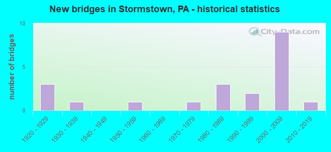
- New bridges - historical statistics
- 31920-1929
- 11930-1939
- 11950-1959
- 11970-1979
- 31980-1989
- 21990-1999
- 92000-2009
- 12010-2019

- Reconstructed bridges - Historical Statistics
- 21940-1949
- 01950-1959
- 01960-1969
- 01970-1979
- 01980-1989
- 01990-1999
- 12000-2009
- 12010-2019


- Bridge Condition - Deck
- 53.8%Good
- 23.1%Satisfactory
- 23.1%Fair

- Bridge Condition - Superstructure
- 7.7%Very good
- 53.8%Good
- 15.4%Satisfactory
- 23.1%Fair

- Bridge Condition - Substructure
- 38.5%Good
- 38.5%Satisfactory
- 15.4%Fair
- 7.7%Poor

- Bridge Condition - Channel
- 25.0%Very good
- 50.0%Satisfactory
- 8.3%Fair
- 16.7%Poor

- Bridge Condition - Culverts
- 50.0%Very good
- 50.0%Good
Find on map >> Show street view
Structure Number: 9425, Location: HANNAH (Lat: 40.766964, Lng: -78.098458), Route carried "on" structure: US 220B, Year Built: 1926, Year Reconstructed: 1952, Status: Open, Structure Length: 1.31m (4.30ft), Average Daily Traffic: 1,286 (year 2021), Truck Traffic: 8%, Average Future Daily Traffic: 2,036 (year 2040), Design Load: H 15, Features Intersected: SPARROW RUN, Facility Carried by Structure: SR 220-US 220
Minimum Vertical Clearance: 30+ m (98+ ft), Kilometerpoint: 3.130, Lanes on structure: 2, Owner: State Highway Agency, Approaching Roadway Width: 7.0m (23.0ft), Material/Design: Concrete, Design/Construction: Tee Beam, Number Of Spans In Main Unit: 1, Length of Maximum Span: 12.2m (40.0ft), Curb-To-Curb Width: 11.6m (38.1ft), Out-to-Out Width: 12.7m (41.7ft)
Condition: Deck: Fair, Superstructure: Fair, Substructure: Fair, Channel: Satisfactory, Operating Rating: 68.9 metric tons, Method Used To Determine Operating Rating: Field evaluation and documented engineering judgment, Inventory Rating: 40.8 metric tons, Method Used To Determine Inventory Rating: Field evaluation and documented engineering judgment, Structural Evaluation: Somewhat better than minimum adequacy, Deck Geometry: Equal to present minimum criteria, Waterway Adequacy: Equal to present minimum criteria, Approach Roadway Alignment: Equal to present desirable criteria, Length Of Structure Improvement: 1.30m (4.27ft), Designated Inspection Frequency: Every 24 months, Inspection Date: May 2020, Bridge Improvement Cost: $39,000, Roadway Improvement Cost: $250,000, Total Project Cost: $522,000, Deck Structure Type: Concrete Cast-file-Place, Wearing Surface/Protective System: Wearing Surface: Bituminous
Find on map >> Show street view
Structure Number: 9427, Location: 2 MI SW PORT MATILDA (Lat: 40.780308, Lng: -78.081661), Route carried "on" structure: US 220B, Year Built: 1952, Year Reconstructed: 2010, Status: Open, Structure Length: 0.64m (2.10ft), Average Daily Traffic: 1,286 (year 2021), Truck Traffic: 8%, Average Future Daily Traffic: 2,036 (year 2040), Design Load: HS 20, Features Intersected: BRANCH BALD EAGLE CREEK, Facility Carried by Structure: SR 220-US 220
Minimum Vertical Clearance: 30+ m (98+ ft), Kilometerpoint: 5.491, Lanes on structure: 2, Owner: State Highway Agency, Approaching Roadway Width: 9.1m (29.9ft), Material/Design: Prestressed concrete, Design/Construction: Box Beam or Girders - Multiple, Number Of Spans In Main Unit: 1, Length of Maximum Span: 6.1m (20.0ft), Curb-To-Curb Width: 10.7m (35.1ft), Out-to-Out Width: 11.9m (39.0ft)
Condition: Deck: Good, Superstructure: Satisfactory, Substructure: Fair, Channel: Poor, Operating Rating: 90.7 metric tons, Method Used To Determine Operating Rating: Load Factor (LF), Inventory Rating: 56.2 metric tons, Method Used To Determine Inventory Rating: Load Factor (LF), Structural Evaluation: Somewhat better than minimum adequacy, Deck Geometry: Equal to present minimum criteria, Waterway Adequacy: Equal to present minimum criteria, Approach Roadway Alignment: Equal to present desirable criteria, Length Of Structure Improvement: 0.60m (1.97ft), Designated Inspection Frequency: Every 24 months, Inspection Date: May 2020, Bridge Improvement Cost: $22,000, Roadway Improvement Cost: $190,000, Total Project Cost: $294,000, Deck Structure Type: Concrete Cast-file-Place, Wearing Surface/Protective System: Wearing Surface: Monolithic Concrete, Deck Protection: Epoxy Coated Reinforcing
Find on map >> Show street view
Structure Number: 9442, Location: 1 MI E MARTHA FURNACE (Lat: 40.839078, Lng: -77.996122), Route carried "on" structure: US 2200, Year Built: 1925, Year Reconstructed: 1953, Status: Open, Structure Length: 1.04m (3.41ft), Average Daily Traffic: 2,670 (year 2021), Truck Traffic: 10%, Average Future Daily Traffic: 3,214 (year 2040), Design Load: H 15, Features Intersected: STEEL HOLLOW RUN, Facility Carried by Structure: SR 3040
Minimum Vertical Clearance: 30+ m (98+ ft), Kilometerpoint: 15.335, Lanes on structure: 2, Base Highway Network: Yes, Owner: State Highway Agency, Approaching Roadway Width: 9.1m (29.9ft), Material/Design: Concrete, Design/Construction: Tee Beam, Number Of Spans In Main Unit: 1, Length of Maximum Span: 9.8m (32.2ft), Curb or Sidewalk Widths: Left: 0.2m (0.7ft), Right: 0.0m, Curb-To-Curb Width: 10.6m (34.8ft), Out-to-Out Width: 11.8m (38.7ft)
Condition: Deck: Fair, Superstructure: Fair, Substructure: Satisfactory, Channel: Satisfactory, Operating Rating: 73.5 metric tons, Method Used To Determine Operating Rating: Field evaluation and documented engineering judgment, Inventory Rating: 43.5 metric tons, Method Used To Determine Inventory Rating: Field evaluation and documented engineering judgment, Structural Evaluation: Somewhat better than minimum adequacy, Deck Geometry: Somewhat better than minimum adequacy, Waterway Adequacy: Equal to present minimum criteria, Approach Roadway Alignment: Equal to present desirable criteria, Length Of Structure Improvement: 1.00m (3.28ft), Designated Inspection Frequency: Every 24 months, Inspection Date: June 2020, Bridge Improvement Cost: $31,000, Roadway Improvement Cost: $250,000, Total Project Cost: $414,000, Deck Structure Type: Concrete Cast-file-Place, Wearing Surface/Protective System: Wearing Surface: Bituminous
Find on map >> Show street view
Structure Number: 9481, Location: MARTHA FURNACE (Lat: 40.828231, Lng: -78.014272), Route carried "on" structure: State highway , Year Built: 1987, Status: Open, Structure Length: 8.44m (27.69ft), Average Daily Traffic: 1,257 (year 2021), Truck Traffic: 5%, Average Future Daily Traffic: 1,673 (year 2041), Design Load: HS 20+Mod, Features Intersected: SEDA-COG/NIT& BALD EAGLE, Facility Carried by Structure: SR 322-US 322
Minimum Vertical Clearance: 30+ m (98+ ft), Kilometerpoint: 2.148, Lanes on structure: 2, Base Highway Network: Yes, Owner: State Highway Agency, Approaching Roadway Width: 10.7m (35.1ft), Skew: 2 degrees, Material/Design: Prestressed concrete, Design/Construction: Stringer/Multi-beam, Number Of Spans In Main Unit: 3, Length of Maximum Span: 34.7m (113.8ft), Curb or Sidewalk Widths: Left: 0.2m (0.7ft), Right: 0.2m (0.7ft), Curb-To-Curb Width: 10.9m (35.8ft), Out-to-Out Width: 11.6m (38.1ft)
Condition: Deck: Good, Superstructure: Good, Substructure: Satisfactory, Channel: Very good, Operating Rating: 70.8 metric tons, Method Used To Determine Operating Rating: Load Factor (LF), Inventory Rating: 41.7 metric tons, Method Used To Determine Inventory Rating: Load Factor (LF), Structural Evaluation: Equal to present minimum criteria, Deck Geometry: Somewhat better than minimum adequacy, Underclear: High priority of corrective action, Waterway Adequacy: Superior to present desirable criteria, Approach Roadway Alignment: Equal to present desirable criteria, Length Of Structure Improvement: 8.40m (27.56ft), Designated Inspection Frequency: Every 24 months, Inspection Date: June 2021, Deck Structure Type: Concrete Cast-file-Place, Wearing Surface/Protective System: Wearing Surface: Epoxy Overlay, Deck Protection: Epoxy Coated Reinforcing
Find on map >> Show street view
Structure Number: 9483, Location: MARTHA FURNACE (Lat: 40.828356, Lng: -78.014131), Route carried "on" structure: State highway , Year Built: 1987, Status: Open, Structure Length: 8.44m (27.69ft), Average Daily Traffic: 1,257 (year 2021), Truck Traffic: 5%, Average Future Daily Traffic: 1,673 (year 2041), Design Load: HS 20+Mod, Features Intersected: SEDA-COG/NIT& BALD EAGLE, Facility Carried by Structure: SR 3042
Minimum Vertical Clearance: 30+ m (98+ ft), Kilometerpoint: 2.148, Lanes on structure: 2, Base Highway Network: Yes, Owner: State Highway Agency, Approaching Roadway Width: 10.7m (35.1ft), Skew: 2 degrees, Material/Design: Prestressed concrete, Design/Construction: Stringer/Multi-beam, Number Of Spans In Main Unit: 3, Length of Maximum Span: 34.7m (113.8ft), Curb or Sidewalk Widths: Left: 0.2m (0.7ft), Right: 0.2m (0.7ft), Curb-To-Curb Width: 10.9m (35.8ft), Out-to-Out Width: 11.7m (38.4ft)
Condition: Deck: Good, Superstructure: Good, Substructure: Good, Channel: Very good, Operating Rating: 70.8 metric tons, Method Used To Determine Operating Rating: Load Factor (LF), Inventory Rating: 41.7 metric tons, Method Used To Determine Inventory Rating: Load Factor (LF), Structural Evaluation: Better than present minimum criteria, Deck Geometry: Somewhat better than minimum adequacy, Underclear: High priority of corrective action, Waterway Adequacy: Superior to present desirable criteria, Approach Roadway Alignment: Equal to present desirable criteria, Length Of Structure Improvement: 9.40m (30.84ft), Designated Inspection Frequency: Every 24 months, Inspection Date: June 2021, Deck Structure Type: Concrete Cast-file-Place, Wearing Surface/Protective System: Wearing Surface: Epoxy Overlay, Deck Protection: Epoxy Coated Reinforcing
Find on map >> Show street view
Structure Number: 9733, Location: CENTENNIAL (Lat: 40.754111, Lng: -78.038486), Route carried "on" structure: State highway , Year Built: 1989, Status: Open, Structure Length: 1.28m (4.20ft), Average Daily Traffic: 537 (year 2020), Truck Traffic: 6%, Average Future Daily Traffic: 735 (year 2041), Design Load: HS 25 or greater, Features Intersected: HALF MOON CREEK, Facility Carried by Structure: ON TSR 966
Minimum Vertical Clearance: 30+ m (98+ ft), Kilometerpoint: 0.005, Lanes on structure: 2, Owner: State Highway Agency, Approaching Roadway Width: 5.5m (18.0ft), Skew: 3 degrees, Material/Design: Concrete, Design/Construction: Culvert, Number Of Spans In Main Unit: 2, Length of Maximum Span: 5.8m (19.0ft), Curb-To-Curb Width: 8.0m (26.2ft), Out-to-Out Width: 16.8m (55.1ft)
Condition: Channel: Satisfactory, Culverts: Good, Operating Rating: 78.0 metric tons, Method Used To Determine Operating Rating: Load Factor (LF), Inventory Rating: 46.3 metric tons, Method Used To Determine Inventory Rating: Load Factor (LF), Structural Evaluation: Better than present minimum criteria, Deck Geometry: Somewhat better than minimum adequacy, Waterway Adequacy: Better than present minimum criteria, Approach Roadway Alignment: Equal to present desirable criteria, Length Of Structure Improvement: 1.30m (4.27ft), Designated Inspection Frequency: Every 24 months, Inspection Date: May 2021
Find on map >> Show street view
Structure Number: 9734, Location: CENTENNIAL (Lat: 40.759361, Lng: -78.037914), Route carried "on" structure: State highway , Year Built: 1977, Status: Open, Structure Length: 0.98m (3.22ft), Average Daily Traffic: 975 (year 2021), Truck Traffic: 9%, Average Future Daily Traffic: 1,071 (year 2041), Design Load: H 20, Features Intersected: HALF MOON CREEK, Facility Carried by Structure: ON TSR 966
Minimum Vertical Clearance: 30+ m (98+ ft), Kilometerpoint: 0.018, Lanes on structure: 2, Owner: State Highway Agency, Approaching Roadway Width: 6.1m (20.0ft), Skew: 3 degrees, Material/Design: Prestressed concrete, Design/Construction: Box Beam or Girders - Multiple, Number Of Spans In Main Unit: 1, Length of Maximum Span: 9.1m (29.9ft), Curb or Sidewalk Widths: Left: 0.2m (0.7ft), Right: 0.2m (0.7ft), Curb-To-Curb Width: 10.5m (34.4ft), Out-to-Out Width: 11.5m (37.7ft)
Condition: Deck: Good, Superstructure: Good, Substructure: Good, Channel: Satisfactory, Operating Rating: 78.0 metric tons, Method Used To Determine Operating Rating: Load Factor (LF), Inventory Rating: 39.0 metric tons, Method Used To Determine Inventory Rating: Load Factor (LF), Structural Evaluation: Better than present minimum criteria, Deck Geometry: Equal to present minimum criteria, Waterway Adequacy: Better than present minimum criteria, Approach Roadway Alignment: Equal to present desirable criteria, Length Of Structure Improvement: 1.00m (3.28ft), Designated Inspection Frequency: Every 24 months, Inspection Date: May 2021, Deck Structure Type: Concrete Precast Panels, Wearing Surface/Protective System: Wearing Surface: Monolithic Concrete, Deck Protection: Epoxy Coated Reinforcing
Find on map >> Show street view
Structure Number: 9751, Location: HANNAH (Lat: 40.769931, Lng: -78.103006), Route carried "on" structure: State highway , Year Built: 1939, Year Reconstructed: 2007, Status: Open, Structure Length: 1.10m (3.61ft), Average Daily Traffic: 46 (year 2020), Truck Traffic: 5%, Average Future Daily Traffic: 48 (year 2038), Design Load: H 20, Features Intersected: SPARROW RUN, Facility Carried by Structure: SR 3025
Minimum Vertical Clearance: 30+ m (98+ ft), Kilometerpoint: 12.913, Lanes on structure: 2, Owner: State Highway Agency, Approaching Roadway Width: 5.8m (19.0ft), Skew: 3 degrees, Material/Design: Steel, Design/Construction: Stringer/Multi-beam, Number Of Spans In Main Unit: 1, Length of Maximum Span: 10.7m (35.1ft), Curb or Sidewalk Widths: Left: 0.2m (0.7ft), Right: 0.2m (0.7ft), Curb-To-Curb Width: 7.1m (23.3ft), Out-to-Out Width: 7.6m (24.9ft)
Condition: Deck: Good, Superstructure: Good, Substructure: Satisfactory, Channel: Satisfactory, Operating Rating: 56.2 metric tons, Method Used To Determine Operating Rating: Load Factor (LF), Inventory Rating: 33.6 metric tons, Method Used To Determine Inventory Rating: Load Factor (LF), Structural Evaluation: Equal to present minimum criteria, Deck Geometry: Somewhat better than minimum adequacy, Waterway Adequacy: Better than present minimum criteria, Approach Roadway Alignment: Better than present minimum criteria, Length Of Structure Improvement: 1.10m (3.61ft), Designated Inspection Frequency: Every 24 months, Inspection Date: May 2020, Bridge Improvement Cost: $38,000, Roadway Improvement Cost: $250,000, Total Project Cost: $510,000, Deck Structure Type: Closed Grating, Wearing Surface/Protective System: Wearing Surface: Monolithic Concrete
Find on map >> Show street view
Structure Number: 9844, Location: 585 FT SOUTH INT RT 220 (Lat: 40.766392, Lng: -78.096167), Route carried "on" structure: ServiceCity street , Year Built: 1925, Status: Open, Structure Length: 1.01m (3.31ft), Average Daily Traffic: 50 (year 2021), Average Future Daily Traffic: 77 (year 2043), Design Load: HS 20, Features Intersected: BALD EAGLE CREEK, Facility Carried by Structure: T-305 E. HANNAH LN
Minimum Vertical Clearance: 30+ m (98+ ft), Kilometerpoint: 0.000, Lanes on structure: 1, Owner: Town or Township Highway Agency, Approaching Roadway Width: 3.4m (11.2ft), Material/Design: Steel, Design/Construction: Stringer/Multi-beam, Number Of Spans In Main Unit: 1, Length of Maximum Span: 9.8m (32.2ft), Curb or Sidewalk Widths: Left: 0.2m (0.7ft), Right: 0.2m (0.7ft), Curb-To-Curb Width: 4.7m (15.4ft), Out-to-Out Width: 5.4m (17.7ft)
Condition: Deck: Fair, Superstructure: Fair, Substructure: Poor, Channel: Fair, Operating Rating: 77.1 metric tons, Method Used To Determine Operating Rating: Load Factor (LF), Inventory Rating: 46.3 metric tons, Method Used To Determine Inventory Rating: Load Factor (LF), Structural Evaluation: Meets minimum limits, Deck Geometry: Better than present minimum criteria, Waterway Adequacy: Equal to present desirable criteria, Approach Roadway Alignment: Somewhat better than minimum adequacy, Length Of Structure Improvement: 1.60m (5.25ft), Designated Inspection Frequency: Every 24 months, Inspection Date: July 2021, Bridge Improvement Cost: $4,000, Roadway Improvement Cost: $12,000, Total Project Cost: $55,000, Deck Structure Type: Concrete Cast-file-Place, Wearing Surface/Protective System: Wearing Surface: Gravel
Find on map >> Show street view
Structure Number: 40135, Location: 90 FT SOUTH INT US 220 (Lat: 40.767264, Lng: -78.097514), Route carried "on" structure: ServiceCity street , Year Built: 1995, Status: Open, Structure Length: 1.07m (3.51ft), Average Daily Traffic: 50 (year 2021), Average Future Daily Traffic: 77 (year 2043), Design Load: HS 20, Features Intersected: SPARROW RUN, Facility Carried by Structure: T-305 E. HANNAH LN
Minimum Vertical Clearance: 30+ m (98+ ft), Kilometerpoint: 0.000, Lanes on structure: 1, Owner: Town or Township Highway Agency, Approaching Roadway Width: 3.0m (9.8ft), Material/Design: Steel, Design/Construction: Stringer/Multi-beam, Number Of Spans In Main Unit: 1, Length of Maximum Span: 9.8m (32.2ft), Curb-To-Curb Width: 4.5m (14.8ft), Out-to-Out Width: 4.9m (16.1ft)
Condition: Deck: Satisfactory, Superstructure: Good, Substructure: Satisfactory, Channel: Poor, Operating Rating: 52.6 metric tons, Method Used To Determine Operating Rating: Load Factor (LF), Inventory Rating: 31.8 metric tons, Method Used To Determine Inventory Rating: Load Factor (LF), Structural Evaluation: Equal to present minimum criteria, Deck Geometry: Equal to present minimum criteria, Waterway Adequacy: Equal to present minimum criteria, Approach Roadway Alignment: Equal to present desirable criteria, Length Of Structure Improvement: 1.60m (5.25ft), Designated Inspection Frequency: Every 24 months, Inspection Date: July 2021, Deck Structure Type: Wood or Timber
Find on map >> Show street view
Structure Number: 40814, Location: 1.1 MI. WEST OF GATESBURG (Lat: 40.743914, Lng: -78.027178), Route carried "on" structure: City street , Year Built: 1999, Status: Open, Structure Length: 0.82m (2.69ft), Average Daily Traffic: 250 (year 2021), Average Future Daily Traffic: 364 (year 2043), Design Load: HS 25 or greater, Features Intersected: HALFMOON CREEK, Facility Carried by Structure: T-307 GATESBURG RD
Minimum Vertical Clearance: 30+ m (98+ ft), Kilometerpoint: 0.000, Lanes on structure: 2, Owner: Town or Township Highway Agency, Approaching Roadway Width: 7.3m (24.0ft), Skew: 1 degrees, Material/Design: Concrete, Design/Construction: Frame, Number Of Spans In Main Unit: 1, Length of Maximum Span: 7.6m (24.9ft), Curb-To-Curb Width: 7.3m (24.0ft), Out-to-Out Width: 8.5m (27.9ft)
Condition: Deck: Satisfactory, Superstructure: Satisfactory, Substructure: Good, Channel: Satisfactory, Inventory Rating: 64.4 metric tons, Method Used To Determine Inventory Rating: Load Factor (LF), Structural Evaluation: Equal to present minimum criteria, Deck Geometry: Somewhat better than minimum adequacy, Waterway Adequacy: Better than present minimum criteria, Approach Roadway Alignment: Equal to present desirable criteria, Length Of Structure Improvement: 1.40m (4.59ft), Designated Inspection Frequency: Every 24 months, Inspection Date: May 2021, Wearing Surface/Protective System: Wearing Surface: Bituminous
Find on map >> Show street view
Structure Number: 41369, Location: 3 MI N STATE COLLEGE (Lat: 40.829383, Lng: -78.016694), Route carried "on" structure: US 322, Year Built: 2001, Status: Open, Structure Length: 4.54m (14.90ft), Average Daily Traffic: 6,496 (year 2020), Truck Traffic: 16%, Average Future Daily Traffic: 17,350 (year 2041), Design Load: HS 20, Features Intersected: RAMP W-S
Minimum Vertical Clearance: 30+ m (98+ ft), Kilometerpoint: 20.649, Lanes on structure: 2, Lanes under structure: 1, Base Highway Network: Yes, Owner: State Highway Agency, Approaching Roadway Width: 12.2m (40.0ft), Skew: 6 degrees, Material/Design: Prestressed concrete, Design/Construction: Stringer/Multi-beam, Number Of Spans In Main Unit: 1, Length of Maximum Span: 42.1m (138.1ft), Curb or Sidewalk Widths: Left: 0.2m (0.7ft), Right: 0.2m (0.7ft), Curb-To-Curb Width: 12.2m (40.0ft), Out-to-Out Width: 13.0m (42.7ft)
Condition: Deck: Satisfactory, Superstructure: Good, Substructure: Good, Inventory Rating: 54.4 metric tons, Method Used To Determine Inventory Rating: Load Factor (LF), Structural Evaluation: Better than present minimum criteria, Deck Geometry: Better than present minimum criteria, Underclear: Superior to present desirable criteria, Approach Roadway Alignment: Equal to present desirable criteria, Length Of Structure Improvement: 5.50m (18.04ft), Designated Inspection Frequency: Every 24 months, Inspection Date: July 2021, Deck Structure Type: Concrete Cast-file-Place, Wearing Surface/Protective System: Wearing Surface: Monolithic Concrete, Deck Protection: Epoxy Coated Reinforcing
Find on map >> Show street view
Structure Number: 41536, Location: 1 MI N STATE COLLEGE (Lat: 40.829389, Lng: -78.016722), Route carried "on" structure: US 322, Year Built: 2001, Status: Open, Structure Length: 4.08m (13.39ft), Average Daily Traffic: 6,496 (year 2020), Truck Traffic: 16%, Average Future Daily Traffic: 17,350 (year 2041), Design Load: H 15, Features Intersected: SR 3007
Minimum Vertical Clearance: 30+ m (98+ ft), Kilometerpoint: 20.649, Lanes on structure: 2, Lanes under structure: 10, Base Highway Network: Yes, Owner: State Highway Agency, Approaching Roadway Width: 11.6m (38.1ft), Material/Design: Steel, Design/Construction: Stringer/Multi-beam, Number Of Spans In Main Unit: 1, Length of Maximum Span: 39.6m (129.9ft), Curb or Sidewalk Widths: Left: 0.1m (0.3ft), Right: 0.1m (0.3ft), Curb-To-Curb Width: 12.2m (40.0ft), Out-to-Out Width: 13.0m (42.7ft)
Condition: Deck: Good, Superstructure: Very good, Substructure: Satisfactory, Operating Rating: 95.3 metric tons, Method Used To Determine Operating Rating: Load Factor (LF), Inventory Rating: 57.2 metric tons, Method Used To Determine Inventory Rating: Load Factor (LF), Structural Evaluation: Equal to present minimum criteria, Deck Geometry: Better than present minimum criteria, Underclear: Equal to present desirable criteria, Approach Roadway Alignment: Equal to present desirable criteria, Length Of Structure Improvement: 4.90m (16.08ft), Designated Inspection Frequency: Every 24 months, Inspection Date: July 2021, Deck Structure Type: Concrete Cast-file-Place, Wearing Surface/Protective System: Wearing Surface: Monolithic Concrete, Deck Protection: Epoxy Coated Reinforcing
Find on map >> Show street view
Structure Number: 41718, Location: 2 M N OF STATE COLLEGE (Lat: 40.829306, Lng: -78.016556), Route carried "on" structure: State highway , Year Built: 2002, Status: Open, Structure Length: 7.44m (24.41ft), Average Daily Traffic: 8,431 (year 2021), Truck Traffic: 6%, Average Future Daily Traffic: 11,463 (year 2040), Design Load: HL 93, Features Intersected: SR 99 AND RAMPS, Facility Carried by Structure: SR 3042
Minimum Vertical Clearance: 30+ m (98+ ft), Kilometerpoint: 9.654, Lanes on structure: 3, Lanes under structure: 5, Base Highway Network: Yes, Owner: State Highway Agency, Approaching Roadway Width: 17.1m (56.1ft), Skew: 1 degrees, Material/Design: Prestressed concrete continuous, Design/Construction: Stringer/Multi-beam, Number Of Spans In Main Unit: 2, Length of Maximum Span: 36.9m (121.1ft), Curb or Sidewalk Widths: Left: 0.1m (0.3ft), Right: 0.1m (0.3ft), Curb-To-Curb Width: 17.1m (56.1ft), Out-to-Out Width: 17.9m (58.7ft)
Condition: Deck: Good, Superstructure: Good, Substructure: Good, Operating Rating: 76.2 metric tons, Method Used To Determine Operating Rating: Load and Resistance Factor (LRFR), Inventory Rating: 45.4 metric tons, Method Used To Determine Inventory Rating: Load and Resistance Factor (LRFR), Structural Evaluation: Better than present minimum criteria, Deck Geometry: Superior to present desirable criteria, Underclear: High priority of corrective action, Approach Roadway Alignment: Equal to present desirable criteria, Length Of Structure Improvement: 8.40m (27.56ft), Designated Inspection Frequency: Every 24 months, Inspection Date: July 2020, Deck Structure Type: Concrete Cast-file-Place, Wearing Surface/Protective System: Wearing Surface: Monolithic Concrete, Deck Protection: Epoxy Coated Reinforcing
Find on map >> Show street view
Structure Number: 56944, Location: 0.4 MI NW OF U.S. 220 (Lat: 40.835789, Lng: -78.016094), Route carried "on" structure: City street , Year Built: 2019, Status: Open, Structure Length: 0.64m (2.10ft), Average Daily Traffic: 50 (year 2021), Truck Traffic: 1%, Average Future Daily Traffic: 60 (year 2043), Design Load: HL 93, Features Intersected: ARDERY RUN, Facility Carried by Structure: T-348 ARDERY RD
Minimum Vertical Clearance: 30+ m (98+ ft), Kilometerpoint: 0.000, Lanes on structure: 2, Owner: Town or Township Highway Agency, Approaching Roadway Width: 6.7m (22.0ft), Skew: 4 degrees, Material/Design: Concrete, Design/Construction: Culvert, Number Of Spans In Main Unit: 1, Length of Maximum Span: 6.4m (21.0ft), Curb-To-Curb Width: 6.7m (22.0ft), Out-to-Out Width: 11.6m (38.1ft)
Condition: Channel: Very good, Culverts: Very good, Operating Rating: 60.6 metric tons, Method Used To Determine Operating Rating: Assigned ratings based on Load and Resistance Factor Design (LRFD) reported by rating factor (RF) using HL93 loadings, Inventory Rating: 38.2 metric tons, Method Used To Determine Inventory Rating: Assigned ratings based on Load and Resistance Factor Design (LRFD) reported by rating factor (RF) using HL93 loadings, Structural Evaluation: Equal to present desirable criteria, Deck Geometry: Somewhat better than minimum adequacy, Waterway Adequacy: Better than present minimum criteria, Approach Roadway Alignment: Equal to present desirable criteria, Designated Inspection Frequency: Every 24 months, Inspection Date: June 2021, Wearing Surface/Protective System: Wearing Surface: Bituminous, Membrane: Preformed Fabric, Deck Protection: Epoxy Coated Reinforcing
Find on map >> Show street view
Structure Number: 41369, Location: 3 MI N STATE COLLEGE (Lat: 40.829383, Lng: -78.016694), Route carried "under" structure: Ramp State highway , Year Built: 2001, Structure Length: 0. m, Average Daily Traffic: 4,978 (year 2021), Truck Traffic: 8%, Features Intersected: RAMP W-S, Facility Carried by Structure: SR 322-US 322
Minimum Vertical Clearance: 6.11m (20.05ft), Kilometerpoint: 0.000, Lanes on structure: 2, Lanes under structure: 1, Material/Design: Prestressed concrete, Design/Construction: Stringer/Multi-beam, Length of Maximum Span: 42.1m (138.1ft)
Find on map >> Show street view
Structure Number: 41536, Location: 1 MI N STATE COLLEGE (Lat: 40.829389, Lng: -78.016722), Route carried "under" structure: State highway , Year Built: 2001, Structure Length: 0. m, Average Daily Traffic: 2,609 (year 2021), Truck Traffic: 10%, Features Intersected: SR 3007, Facility Carried by Structure: SR 322-US 322
Minimum Vertical Clearance: 8.76m (28.74ft), Kilometerpoint: 3.587, Lanes on structure: 2, Lanes under structure: 5, Material/Design: Steel, Design/Construction: Stringer/Multi-beam, Length of Maximum Span: 39.6m (129.9ft)
Find on map >> Show street view
Structure Number: 41536, Location: 1 MI N STATE COLLEGE (Lat: 40.829389, Lng: -78.016722), Route carried "under" structure: State highway , Year Built: 2001, Structure Length: 0. m, Average Daily Traffic: 3,682 (year 2021), Truck Traffic: 6%, Features Intersected: SR 3007, Facility Carried by Structure: SR 322-US 322
Minimum Vertical Clearance: 9.07m (29.76ft), Kilometerpoint: 3.587, Lanes on structure: 2, Lanes under structure: 5, Material/Design: Steel, Design/Construction: Stringer/Multi-beam, Length of Maximum Span: 39.6m (129.9ft)
Find on map >> Show street view
Structure Number: 41718, Location: 2 M N OF STATE COLLEGE (Lat: 40.829306, Lng: -78.016556), Route carried "under" structure: Interstate 99, Year Built: 2002, Structure Length: 0. m, Average Daily Traffic: 11,499 (year 2021), Truck Traffic: 15%, Features Intersected: SR 99 AND RAMPS, Facility Carried by Structure: SR 3042
Minimum Vertical Clearance: 5.29m (17.36ft), Kilometerpoint: 21.078, Lanes on structure: 3, Lanes under structure: 2, Material/Design: Prestressed concrete continuous, Design/Construction: Stringer/Multi-beam, Length of Maximum Span: 36.9m (121.1ft)
Find on map >> Show street view
Structure Number: 41718, Location: 2 M N OF STATE COLLEGE (Lat: 40.829306, Lng: -78.016556), Route carried "under" structure: Interstate 99, Year Built: 2002, Structure Length: 0. m, Average Daily Traffic: 11,327 (year 2021), Truck Traffic: 16%, Features Intersected: SR 99 AND RAMPS, Facility Carried by Structure: SR 3042
Minimum Vertical Clearance: 5.08m (16.67ft), Kilometerpoint: 20.992, Lanes on structure: 3, Lanes under structure: 2, Material/Design: Prestressed concrete continuous, Design/Construction: Stringer/Multi-beam, Length of Maximum Span: 36.9m (121.1ft)
Find on map >> Show street view
Structure Number: 41718, Location: 2 M N OF STATE COLLEGE (Lat: 40.829306, Lng: -78.016556), Route carried "under" structure: Ramp State highway , Year Built: 2002, Structure Length: 0. m, Average Daily Traffic: 1,649 (year 2021), Truck Traffic: 13%, Features Intersected: SR 99 AND RAMPS, Facility Carried by Structure: SR 3042
Minimum Vertical Clearance: 5.59m (18.34ft), Kilometerpoint: 0.000, Lanes on structure: 3, Lanes under structure: 1, Material/Design: Prestressed concrete continuous, Design/Construction: Stringer/Multi-beam, Length of Maximum Span: 36.9m (121.1ft)