Bridge Statistics for Strawberry Point, Iowa (IA)
Condition, Traffic, Stress, Structural Evaluation, Project Costs
- National Bridge Inventory (NBI) Statistics
- 17Number of bridges
- 115ft / 34.8mTotal length
- 5,820Total average daily traffic
- 901Total average daily truck traffic
- 5,820Total future (year 2040) average daily traffic
- National Bridge Inventory (NBI) Registered Bridges for Strawberry Point
- No street view available for this location
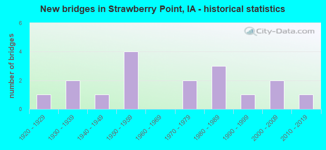
- New bridges - historical statistics
- 11920-1929
- 21930-1939
- 11940-1949
- 41950-1959
- 21970-1979
- 31980-1989
- 11990-1999
- 22000-2009
- 12010-2019


- Bridge Condition - Deck
- 36.4%Good
- 45.5%Satisfactory
- 18.2%Fair

- Bridge Condition - Superstructure
- 45.5%Good
- 36.4%Satisfactory
- 18.2%Fair

- Bridge Condition - Substructure
- 36.4%Good
- 27.3%Satisfactory
- 27.3%Fair
- 9.1%Poor

- Bridge Condition - Channel
- 29.4%Very good
- 29.4%Good
- 41.2%Satisfactory

- Bridge Condition - Culverts
- 66.7%Good
- 16.7%Satisfactory
- 16.7%Fair
Find on map >> Show street view
Structure Number: 20581, Location: 3.0 mi. S of jct. SR C24 (Lat: 42.744742, Lng: -91.497625), Route carried "on" structure: State highway 13, Year Built: 1978, Status: Open, Structure Length: 3.96m (12.99ft), Average Daily Traffic: 2,030 (year 2020), Truck Traffic: 21%, Average Future Daily Traffic: 2,030 (year 2040), Design Load: HS 20, Features Intersected: COX CREEK
Minimum Vertical Clearance: 30+ m (98+ ft), Kilometerpoint: 103.407, Lanes on structure: 2, Base Highway Network: Yes, Owner: State Highway Agency, Approaching Roadway Width: 13.4m (44.0ft), Skew: 1 degrees, Material/Design: Concrete continuous, Design/Construction: Slab, Number Of Spans In Main Unit: 3, Length of Maximum Span: 15.5m (50.9ft), Curb-To-Curb Width: 13.4m (44.0ft), Out-to-Out Width: 14.4m (47.2ft)
Condition: Deck: Satisfactory, Superstructure: Satisfactory, Substructure: Good, Channel: Good, Operating Rating: 46.1 metric tons, Method Used To Determine Operating Rating: Allowable Stress (AS), Inventory Rating: 17.1 metric tons, Method Used To Determine Inventory Rating: Allowable Stress (AS), Structural Evaluation: Meets minimum limits, Deck Geometry: Better than present minimum criteria, Waterway Adequacy: Equal to present desirable criteria, Approach Roadway Alignment: Equal to present desirable criteria, Designated Inspection Frequency: Every 24 months, Inspection Date: May 2020, Deck Structure Type: Concrete Cast-file-Place, Wearing Surface/Protective System: Wearing Surface: Low Slump Concrete
Find on map >> Show street view
Structure Number: 207, Location: 091062710 (Lat: 42.658994, Lng: -91.538594), Route carried "on" structure: County highway , Year Built: 1928, Status: Open, Structure Length: 0.67m (2.20ft), Average Daily Traffic: 430 (year 2021), Truck Traffic: 6%, Average Future Daily Traffic: 430 (year 2040), Design Load: H 15, Features Intersected: DRAINAGE DITCH, Facility Carried by Structure: HWY 410
Minimum Vertical Clearance: 30+ m (98+ ft), Kilometerpoint: 3.079, Lanes on structure: 2, Owner: County Highway Agency, Approaching Roadway Width: 7.9m (25.9ft), Skew: 2 degrees, Material/Design: Concrete continuous, Design/Construction: Culvert, Number Of Spans In Main Unit: 2, Length of Maximum Span: 3.0m (9.8ft)
Condition: Channel: Satisfactory, Culverts: Fair, Operating Rating: 54.5 metric tons, Method Used To Determine Operating Rating: Field evaluation and documented engineering judgment, Inventory Rating: 32.7 metric tons, Method Used To Determine Inventory Rating: Field evaluation and documented engineering judgment, Structural Evaluation: Somewhat better than minimum adequacy, Waterway Adequacy: Better than present minimum criteria, Approach Roadway Alignment: Somewhat better than minimum adequacy, Designated Inspection Frequency: Every 24 months, Inspection Date: November 2020
Find on map >> Show street view
Structure Number: 2455, Location: 1.7 MI. E OF JCT. 187 (Lat: 42.687597, Lng: -91.612186), Route carried "on" structure: State highway 3, Year Built: 1959, Status: Open, Structure Length: 4.30m (14.11ft), Average Daily Traffic: 2,150 (year 2020), Truck Traffic: 13%, Average Future Daily Traffic: 2,150 (year 2041), Design Load: H 20, Features Intersected: MAQUOKETA RIVER
Minimum Vertical Clearance: 30+ m (98+ ft), Kilometerpoint: 430.926, Lanes on structure: 2, Base Highway Network: Yes, Owner: State Highway Agency, Approaching Roadway Width: 13.4m (44.0ft), Skew: 3 degrees, Material/Design: Prestressed concrete, Design/Construction: Stringer/Multi-beam, Number Of Spans In Main Unit: 3, Length of Maximum Span: 18.3m (60.0ft), Curb-To-Curb Width: 9.4m (30.8ft), Out-to-Out Width: 11.0m (36.1ft)
Condition: Deck: Fair, Superstructure: Good, Substructure: Satisfactory, Channel: Good, Operating Rating: 57.8 metric tons, Method Used To Determine Operating Rating: Load Factor (LF), Inventory Rating: 34.6 metric tons, Method Used To Determine Inventory Rating: Load Factor (LF), Structural Evaluation: Equal to present minimum criteria, Deck Geometry: Meets minimum limits, Waterway Adequacy: Better than present minimum criteria, Approach Roadway Alignment: Equal to present desirable criteria, Designated Inspection Frequency: Every 24 months, Inspection Date: May 2021, Deck Structure Type: Concrete Cast-file-Place, Wearing Surface/Protective System: Wearing Surface: Low Slump Concrete
Find on map >> Show street view
Structure Number: 118492, Location: 091060204 (Lat: 42.730464, Lng: -91.520092), Route carried "on" structure: County highway , Year Built: 2004, Status: Open, Structure Length: 0.82m (2.69ft), Average Daily Traffic: 30 (year 2013), Average Future Daily Traffic: 30 (year 2040), Design Load: HS 20, Features Intersected: KLEINLEIN HOLLOW, Facility Carried by Structure: BELGIAM RD
Minimum Vertical Clearance: 30+ m (98+ ft), Kilometerpoint: 10.599, Lanes on structure: 2, Owner: County Highway Agency, Approaching Roadway Width: 7.3m (24.0ft), Material/Design: Concrete, Design/Construction: Culvert, Number Of Spans In Main Unit: 2, Length of Maximum Span: 3.7m (12.1ft)
Condition: Channel: Very good, Culverts: Good, Operating Rating: 43.7 metric tons, Method Used To Determine Operating Rating: Load and Resistance Factor Rating (LRFR) rating reported by rating factor(RF) method using HL-93 loadings, Inventory Rating: 33.7 metric tons, Method Used To Determine Inventory Rating: Load and Resistance Factor Rating (LRFR) rating reported by rating factor(RF) method using HL-93 loadings, Structural Evaluation: Better than present minimum criteria, Waterway Adequacy: Equal to present desirable criteria, Approach Roadway Alignment: Equal to present minimum criteria, Designated Inspection Frequency: Every 24 months, Inspection Date: November 2020
Find on map >> Show street view
Structure Number: 1185, Location: 091060204 (Lat: 42.725822, Lng: -91.525739), Route carried "on" structure: County highway , Year Built: 1930, Status: Posted for load-capacity, Structure Length: 0.82m (2.69ft), Average Daily Traffic: 30 (year 2013), Average Future Daily Traffic: 30 (year 2040), Features Intersected: STREAM, Facility Carried by Structure: BELGIAM RD
Minimum Vertical Clearance: 30+ m (98+ ft), Kilometerpoint: 9.862, Lanes on structure: 2, Owner: County Highway Agency, Approaching Roadway Width: 7.3m (24.0ft), Material/Design: Concrete, Design/Construction: Culvert, Number Of Spans In Main Unit: 2, Length of Maximum Span: 3.7m (12.1ft), Curb-To-Curb Width: 6.7m (22.0ft), Out-to-Out Width: 7.3m (24.0ft)
Condition: Channel: Satisfactory, Culverts: Satisfactory, Operating Rating: 32.3 metric tons, Method Used To Determine Operating Rating: Field evaluation and documented engineering judgment, Inventory Rating: 23.3 metric tons, Method Used To Determine Inventory Rating: Field evaluation and documented engineering judgment, Structural Evaluation: Equal to present minimum criteria, Deck Geometry: Somewhat better than minimum adequacy, Waterway Adequacy: Somewhat better than minimum adequacy, Approach Roadway Alignment: Meets minimum limits, Length Of Structure Improvement: 3.00m (9.84ft), Designated Inspection Frequency: Every 24 months, Inspection Date: November 2020, Bridge Improvement Cost: $34,000, Roadway Improvement Cost: $2,000, Deck Structure Type: Concrete Cast-file-Place, Wearing Surface/Protective System: Wearing Surface: Monolithic Concrete
Find on map >> Show street view
Structure Number: 118521, Location: 091060704 (Lat: 42.705928, Lng: -91.606317), Route carried "on" structure: County highway , Year Built: 1996, Status: Open, Structure Length: 0.79m (2.59ft), Average Daily Traffic: 40 (year 2017), Average Future Daily Traffic: 40 (year 2040), Features Intersected: STREAM, Facility Carried by Structure: A AVE
Minimum Vertical Clearance: 30+ m (98+ ft), Kilometerpoint: 2.018, Lanes on structure: 2, Owner: County Highway Agency, Approaching Roadway Width: 6.4m (21.0ft), Skew: 4 degrees, Material/Design: Concrete continuous, Design/Construction: Culvert, Number Of Spans In Main Unit: 2, Length of Maximum Span: 4.0m (13.1ft)
Condition: Channel: Good, Culverts: Good, Operating Rating: 44.1 metric tons, Method Used To Determine Operating Rating: Field evaluation and documented engineering judgment, Inventory Rating: 32.7 metric tons, Method Used To Determine Inventory Rating: Field evaluation and documented engineering judgment, Structural Evaluation: Better than present minimum criteria, Waterway Adequacy: Equal to present desirable criteria, Approach Roadway Alignment: Equal to present desirable criteria, Length Of Structure Improvement: 4.00m (13.12ft), Designated Inspection Frequency: Every 24 months, Inspection Date: October 2020, Bridge Improvement Cost: $60,000, Roadway Improvement Cost: $30,000
Find on map >> Show street view
Structure Number: 118531, Location: 091062906 (Lat: 42.667789, Lng: -91.581839), Route carried "on" structure: County highway , Year Built: 2000, Status: Open, Structure Length: 0.67m (2.20ft), Average Daily Traffic: 60 (year 2013), Average Future Daily Traffic: 60 (year 2041), Design Load: HS 20+Mod, Features Intersected: STREAM, Facility Carried by Structure: ACORN RD
Minimum Vertical Clearance: 30+ m (98+ ft), Kilometerpoint: 0.922, Lanes on structure: 2, Owner: County Highway Agency, Approaching Roadway Width: 6.4m (21.0ft), Material/Design: Concrete, Design/Construction: Culvert, Number Of Spans In Main Unit: 2, Length of Maximum Span: 3.0m (9.8ft)
Condition: Channel: Very good, Culverts: Good, Operating Rating: 44.1 metric tons, Method Used To Determine Operating Rating: Field evaluation and documented engineering judgment, Inventory Rating: 32.7 metric tons, Method Used To Determine Inventory Rating: Field evaluation and documented engineering judgment, Structural Evaluation: Better than present minimum criteria, Waterway Adequacy: Equal to present desirable criteria, Approach Roadway Alignment: Equal to present desirable criteria, Length Of Structure Improvement: 2.40m (7.87ft), Designated Inspection Frequency: Every 24 months, Inspection Date: March 2021, Bridge Improvement Cost: $80,000, Roadway Improvement Cost: $30,000
Find on map >> Show street view
Structure Number: 118535, Location: 091063003 (Lat: 42.664381, Lng: -91.587414), Route carried "on" structure: County highway , Year Built: 1951, Year Reconstructed: 1974, Status: Posted for load-capacity, Structure Length: 0.70m (2.30ft), Average Daily Traffic: 10 (year 2013), Average Future Daily Traffic: 10 (year 2040), Features Intersected: SMALL, Facility Carried by Structure: ACORN RD
Minimum Vertical Clearance: 30+ m (98+ ft), Kilometerpoint: 0.122, Lanes on structure: 1, Owner: County Highway Agency, Approaching Roadway Width: 5.5m (18.0ft), Material/Design: Steel, Design/Construction: Stringer/Multi-beam, Number Of Spans In Main Unit: 1, Length of Maximum Span: 6.4m (21.0ft), Curb-To-Curb Width: 4.9m (16.1ft), Out-to-Out Width: 4.9m (16.1ft)
Condition: Deck: Satisfactory, Superstructure: Fair, Substructure: Poor, Channel: Satisfactory, Operating Rating: 17.8 metric tons, Method Used To Determine Operating Rating: Load and Resistance Factor Rating (LRFR) rating reported by rating factor(RF) method using HL-93 loadings, Inventory Rating: 13.6 metric tons, Method Used To Determine Inventory Rating: Load and Resistance Factor Rating (LRFR) rating reported by rating factor(RF) method using HL-93 loadings, Structural Evaluation: Meets minimum limits, Deck Geometry: High priority of corrective action, Waterway Adequacy: Somewhat better than minimum adequacy, Approach Roadway Alignment: Equal to present minimum criteria, Bridge Posting: Required (Relationship of Operating Rating to Maximum Legal Load: > 39.9% below), Length Of Structure Improvement: 4.30m (14.11ft), Designated Inspection Frequency: Every 24 months, Inspection Date: October 2020, Bridge Improvement Cost: $37,000, Roadway Improvement Cost: $20,000, Deck Structure Type: Wood or Timber, Wearing Surface/Protective System: Wearing Surface: Wood or Timber
Find on map >> Show street view
Structure Number: 11854, Location: 091063103 (Lat: 42.658775, Lng: -91.587194), Route carried "on" structure: County highway , Year Built: 1958, Status: Open, Structure Length: 3.81m (12.50ft), Average Daily Traffic: 110 (year 2021), Average Future Daily Traffic: 110 (year 2040), Design Load: H 15, Features Intersected: MAQUOKETA RIVER, Facility Carried by Structure: 390TH ST
Minimum Vertical Clearance: 30+ m (98+ ft), Kilometerpoint: 1.595, Lanes on structure: 2, Owner: County Highway Agency, Approaching Roadway Width: 8.2m (26.9ft), Material/Design: Concrete continuous, Design/Construction: Slab, Number Of Spans In Main Unit: 3, Length of Maximum Span: 14.9m (48.9ft), Curb-To-Curb Width: 7.4m (24.3ft), Out-to-Out Width: 8.0m (26.2ft)
Condition: Deck: Satisfactory, Superstructure: Satisfactory, Substructure: Fair, Channel: Very good, Operating Rating: 24.0 metric tons, Method Used To Determine Operating Rating: Load and Resistance Factor Rating (LRFR) rating reported by rating factor(RF) method using HL-93 loadings, Inventory Rating: 18.5 metric tons, Method Used To Determine Inventory Rating: Load and Resistance Factor Rating (LRFR) rating reported by rating factor(RF) method using HL-93 loadings, Structural Evaluation: Somewhat better than minimum adequacy, Deck Geometry: Somewhat better than minimum adequacy, Waterway Adequacy: Better than present minimum criteria, Approach Roadway Alignment: Better than present minimum criteria, Length Of Structure Improvement: 12.50m (41.01ft), Designated Inspection Frequency: Every 24 months, Inspection Date: October 2020, Bridge Improvement Cost: $20,000, Roadway Improvement Cost: $30,000, Deck Structure Type: Concrete Cast-file-Place, Wearing Surface/Protective System: Wearing Surface: Monolithic Concrete
Find on map >> Show street view
Structure Number: 11855, Location: 091063504 (Lat: 42.645508, Lng: -91.527522), Route carried "on" structure: County highway , Year Built: 1949, Status: Posted for load-capacity, Structure Length: 1.86m (6.10ft), Average Daily Traffic: 570 (year 2021), Truck Traffic: 30%, Average Future Daily Traffic: 570 (year 2040), Design Load: H 20, Features Intersected: STREAM, Facility Carried by Structure: FORESTVILLE RD
Minimum Vertical Clearance: 30+ m (98+ ft), Kilometerpoint: 0.142, Lanes on structure: 2, Owner: County Highway Agency, Approaching Roadway Width: 9.4m (30.8ft), Material/Design: Steel, Design/Construction: Stringer/Multi-beam, Number Of Spans In Main Unit: 1, Length of Maximum Span: 18.6m (61.0ft), Curb-To-Curb Width: 6.8m (22.3ft), Out-to-Out Width: 7.3m (24.0ft)
Condition: Deck: Fair, Superstructure: Fair, Substructure: Fair, Channel: Good, Operating Rating: 34.3 metric tons, Method Used To Determine Operating Rating: Load and Resistance Factor Rating (LRFR) rating reported by rating factor(RF) method using HL-93 loadings, Inventory Rating: 26.6 metric tons, Method Used To Determine Inventory Rating: Load and Resistance Factor Rating (LRFR) rating reported by rating factor(RF) method using HL-93 loadings, Structural Evaluation: Somewhat better than minimum adequacy, Deck Geometry: Meets minimum limits, Waterway Adequacy: Equal to present minimum criteria, Approach Roadway Alignment: Equal to present minimum criteria, Length Of Structure Improvement: 9.10m (29.86ft), Designated Inspection Frequency: Every 24 months, Inspection Date: November 2020, Bridge Improvement Cost: $98,000, Roadway Improvement Cost: $30,000, Deck Structure Type: Concrete Cast-file-Place, Wearing Surface/Protective System: Wearing Surface: Monolithic Concrete
Find on map >> Show street view
Structure Number: 119391, Location: 092063605 (Lat: 42.741183, Lng: -91.506369), Route carried "on" structure: County highway , Year Built: 2012, Status: Open, Structure Length: 3.35m (10.99ft), Average Daily Traffic: 35 (year 2013), Average Future Daily Traffic: 35 (year 2040), Design Load: HS 20, Features Intersected: SPRING CREEK, Facility Carried by Structure: 330TH ST
Minimum Vertical Clearance: 30+ m (98+ ft), Kilometerpoint: 2.741, Lanes on structure: 2, Owner: County Highway Agency, Approaching Roadway Width: 7.3m (24.0ft), Material/Design: Concrete continuous, Design/Construction: Slab, Number Of Spans In Main Unit: 3, Length of Maximum Span: 13.1m (43.0ft), Curb-To-Curb Width: 9.1m (29.9ft), Out-to-Out Width: 10.1m (33.1ft)
Condition: Deck: Good, Superstructure: Good, Substructure: Good, Channel: Very good, Operating Rating: 66.6 metric tons, Method Used To Determine Operating Rating: Load Factor (LF), Inventory Rating: 40.0 metric tons, Method Used To Determine Inventory Rating: Load Factor (LF), Structural Evaluation: Better than present minimum criteria, Deck Geometry: Better than present minimum criteria, Waterway Adequacy: Superior to present desirable criteria, Approach Roadway Alignment: Equal to present minimum criteria, Designated Inspection Frequency: Every 24 months, Inspection Date: November 2020, Deck Structure Type: Concrete Cast-file-Place, Wearing Surface/Protective System: Wearing Surface: Monolithic Concrete, Deck Protection: Epoxy Coated Reinforcing
Find on map >> Show street view
Structure Number: 142711, Location: 090060102 (Lat: 42.639906, Lng: -91.507844), Route carried "on" structure: County highway , Year Built: 1981, Status: Open, Structure Length: 1.89m (6.20ft), Average Daily Traffic: 40 (year 2017), Average Future Daily Traffic: 40 (year 2040), Design Load: HS 20, Features Intersected: SMALL STREAM, Facility Carried by Structure: LOC 150TH AVE
Minimum Vertical Clearance: 30+ m (98+ ft), Kilometerpoint: 25.180, Lanes on structure: 2, Owner: County Highway Agency, Approaching Roadway Width: 7.3m (24.0ft), Skew: 1 degrees, Material/Design: Prestressed concrete, Design/Construction: Tee Beam, Number Of Spans In Main Unit: 2, Length of Maximum Span: 9.1m (29.9ft), Curb-To-Curb Width: 7.3m (24.0ft), Out-to-Out Width: 7.4m (24.3ft)
Condition: Deck: Good, Superstructure: Good, Substructure: Satisfactory, Channel: Satisfactory, Operating Rating: 46.3 metric tons, Method Used To Determine Operating Rating: Load and Resistance Factor Rating (LRFR) rating reported by rating factor(RF) method using HL-93 loadings, Inventory Rating: 35.6 metric tons, Method Used To Determine Inventory Rating: Load and Resistance Factor Rating (LRFR) rating reported by rating factor(RF) method using HL-93 loadings, Structural Evaluation: Equal to present minimum criteria, Deck Geometry: Equal to present minimum criteria, Waterway Adequacy: Equal to present minimum criteria, Approach Roadway Alignment: Equal to present desirable criteria, Designated Inspection Frequency: Every 24 months, Inspection Date: December 2020, Deck Structure Type: Concrete Precast Panels, Wearing Surface/Protective System: Wearing Surface: Monolithic Concrete
Find on map >> Show street view
Structure Number: 142721, Location: 090060304 (Lat: 42.639322, Lng: -91.542250), Route carried "on" structure: County highway , Year Built: 1988, Status: Open, Structure Length: 3.17m (10.40ft), Average Daily Traffic: 45 (year 2017), Average Future Daily Traffic: 45 (year 2040), Design Load: HS 20, Features Intersected: STREAM, Facility Carried by Structure: LOC 130TH AVE
Minimum Vertical Clearance: 30+ m (98+ ft), Kilometerpoint: 23.490, Lanes on structure: 2, Owner: County Highway Agency, Approaching Roadway Width: 7.9m (25.9ft), Material/Design: Concrete continuous, Design/Construction: Slab, Number Of Spans In Main Unit: 3, Length of Maximum Span: 11.6m (38.1ft), Curb-To-Curb Width: 7.4m (24.3ft), Out-to-Out Width: 8.3m (27.2ft)
Condition: Deck: Good, Superstructure: Good, Substructure: Good, Channel: Satisfactory, Operating Rating: 79.6 metric tons, Method Used To Determine Operating Rating: Load Factor (LF), Inventory Rating: 47.7 metric tons, Method Used To Determine Inventory Rating: Load Factor (LF), Structural Evaluation: Better than present minimum criteria, Deck Geometry: Equal to present minimum criteria, Waterway Adequacy: Equal to present desirable criteria, Approach Roadway Alignment: Equal to present desirable criteria, Designated Inspection Frequency: Every 24 months, Inspection Date: December 2020, Deck Structure Type: Concrete Cast-file-Place, Wearing Surface/Protective System: Wearing Surface: Monolithic Concrete
Find on map >> Show street view
Structure Number: 142731, Location: 090060501 (Lat: 42.644031, Lng: -91.579597), Route carried "on" structure: County highway , Year Built: 1986, Status: Open, Structure Length: 5.00m (16.40ft), Average Daily Traffic: 160 (year 2017), Average Future Daily Traffic: 160 (year 2040), Design Load: H 20, Features Intersected: MAQUOKETA RIVER, Facility Carried by Structure: LOC 400TH ST
Minimum Vertical Clearance: 30+ m (98+ ft), Kilometerpoint: 2.251, Lanes on structure: 2, Owner: County Highway Agency, Approaching Roadway Width: 7.9m (25.9ft), Material/Design: Prestressed concrete continuous, Design/Construction: Stringer/Multi-beam, Number Of Spans In Main Unit: 3, Length of Maximum Span: 18.3m (60.0ft), Curb-To-Curb Width: 9.1m (29.9ft), Out-to-Out Width: 10.1m (33.1ft)
Condition: Deck: Good, Superstructure: Good, Substructure: Good, Channel: Satisfactory, Operating Rating: 46.7 metric tons, Method Used To Determine Operating Rating: Load and Resistance Factor Rating (LRFR) rating reported by rating factor(RF) method using HL-93 loadings, Inventory Rating: 36.0 metric tons, Method Used To Determine Inventory Rating: Load and Resistance Factor Rating (LRFR) rating reported by rating factor(RF) method using HL-93 loadings, Structural Evaluation: Better than present minimum criteria, Deck Geometry: Equal to present minimum criteria, Waterway Adequacy: Better than present minimum criteria, Approach Roadway Alignment: Better than present minimum criteria, Designated Inspection Frequency: Every 24 months, Inspection Date: December 2020, Deck Structure Type: Concrete Cast-file-Place, Wearing Surface/Protective System: Wearing Surface: Monolithic Concrete
Find on map >> Show street view
Structure Number: 14275, Location: 090061301 (Lat: 42.614625, Lng: -91.505894), Route carried "on" structure: County highway , Year Built: 1971, Status: Open, Structure Length: 0.73m (2.40ft), Design Load: H 15, Features Intersected: SMALL STREAM, Facility Carried by Structure: LOCAL 120 ST
Minimum Vertical Clearance: 30+ m (98+ ft), Kilometerpoint: 7.107, Lanes on structure: 2, Owner: County Highway Agency, Approaching Roadway Width: 7.9m (25.9ft), Skew: 1 degrees, Material/Design: Concrete, Design/Construction: Tee Beam, Number Of Spans In Main Unit: 1, Length of Maximum Span: 6.7m (22.0ft), Curb-To-Curb Width: 7.3m (24.0ft), Out-to-Out Width: 7.9m (25.9ft)
Condition: Deck: Satisfactory, Superstructure: Satisfactory, Substructure: Fair, Channel: Satisfactory, Operating Rating: 28.2 metric tons, Method Used To Determine Operating Rating: Load and Resistance Factor Rating (LRFR) rating reported by rating factor(RF) method using HL-93 loadings, Inventory Rating: 21.7 metric tons, Method Used To Determine Inventory Rating: Load and Resistance Factor Rating (LRFR) rating reported by rating factor(RF) method using HL-93 loadings, Structural Evaluation: Somewhat better than minimum adequacy, Deck Geometry: Equal to present minimum criteria, Waterway Adequacy: Better than present minimum criteria, Approach Roadway Alignment: Equal to present desirable criteria, Designated Inspection Frequency: Every 24 months, Inspection Date: March 2020, Deck Structure Type: Concrete Precast Panels, Wearing Surface/Protective System: Wearing Surface: Monolithic Concrete
Find on map >> Show street view
Structure Number: 36298, Location: 091063101 (Lat: 42.658783, Lng: -91.601375), Route carried "on" structure: County highway , Year Built: 1958, Status: Open, Structure Length: 0.94m (3.08ft), Average Daily Traffic: 80 (year 2021), Average Future Daily Traffic: 80 (year 2040), Features Intersected: SMALL STREAM, Facility Carried by Structure: 390TH ST
Minimum Vertical Clearance: 30+ m (98+ ft), Kilometerpoint: 0.431, Lanes on structure: 2, Owner: County Highway Agency, Approaching Roadway Width: 7.3m (24.0ft), Skew: 3 degrees, Material/Design: Concrete, Design/Construction: Culvert, Number Of Spans In Main Unit: 2, Length of Maximum Span: 4.3m (14.1ft)
Condition: Channel: Good, Culverts: Good, Operating Rating: 23.2 metric tons, Method Used To Determine Operating Rating: Field evaluation and documented engineering judgment, Inventory Rating: 17.0 metric tons, Method Used To Determine Inventory Rating: Field evaluation and documented engineering judgment, Structural Evaluation: Somewhat better than minimum adequacy, Waterway Adequacy: Better than present minimum criteria, Approach Roadway Alignment: Better than present minimum criteria, Length Of Structure Improvement: 4.00m (13.12ft), Designated Inspection Frequency: Every 24 months, Inspection Date: October 2020, Bridge Improvement Cost: $40,000, Roadway Improvement Cost: $30,000
Find on map >> Show street view
Structure Number: 69901, Location: IN BACKBONE STATE PARK (Lat: 42.637414, Lng: -91.556717), Route carried "on" structure: State lands road , Year Built: 1934, Status: Open, Structure Length: 1.28m (4.20ft), Features Intersected: STREAM, Facility Carried by Structure: BACKBONE ST PK
Minimum Vertical Clearance: 30+ m (98+ ft), Kilometerpoint: 0.847, Lanes on structure: 2, Owner: State Park, Forest, or Reservation Agency, Approaching Roadway Width: 6.1m (20.0ft), Material/Design: Steel, Design/Construction: Stringer/Multi-beam, Number Of Spans In Main Unit: 1, Length of Maximum Span: 12.8m (42.0ft), Curb-To-Curb Width: 6.2m (20.3ft), Out-to-Out Width: 6.5m (21.3ft)
Condition: Deck: Satisfactory, Superstructure: Satisfactory, Substructure: Satisfactory, Channel: Very good, Operating Rating: 32.7 metric tons, Method Used To Determine Operating Rating: Load Factor (LF), Inventory Rating: 19.6 metric tons, Method Used To Determine Inventory Rating: Load Factor (LF), Structural Evaluation: Somewhat better than minimum adequacy, Deck Geometry: Somewhat better than minimum adequacy, Waterway Adequacy: Equal to present minimum criteria, Approach Roadway Alignment: Somewhat better than minimum adequacy, Designated Inspection Frequency: Every 24 months, Inspection Date: March 2020, Deck Structure Type: Concrete Cast-file-Place, Wearing Surface/Protective System: Wearing Surface: Monolithic Concrete