Bridge Statistics for Sturgis, South Dakota (SD)
Condition, Traffic, Stress, Structural Evaluation, Project Costs
- National Bridge Inventory (NBI) Statistics
- 44Number of bridges
- 374ft / 114mTotal length
- $1,468,000Total costs
- 242,589Total average daily traffic
- 24,367Total average daily truck traffic
- National Bridge Inventory (NBI) Registered Bridges for Sturgis
- No street view available for this location
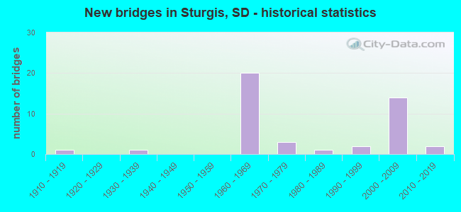
- New bridges - historical statistics
- 11910-1919
- 11930-1939
- 201960-1969
- 31970-1979
- 11980-1989
- 21990-1999
- 142000-2009
- 22010-2019
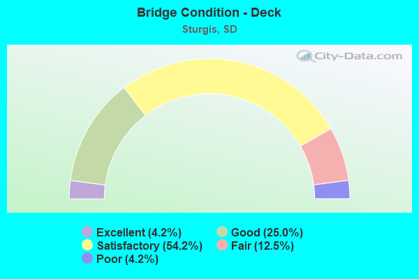
- Bridge Condition - Deck
- 4.2%Excellent
- 25.0%Good
- 54.2%Satisfactory
- 12.5%Fair
- 4.2%Poor
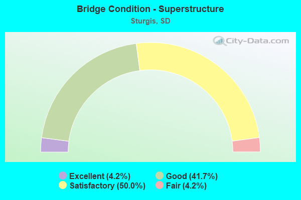
- Bridge Condition - Superstructure
- 4.2%Excellent
- 41.7%Good
- 50.0%Satisfactory
- 4.2%Fair
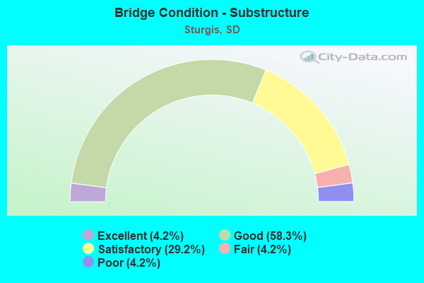
- Bridge Condition - Substructure
- 4.2%Excellent
- 58.3%Good
- 29.2%Satisfactory
- 4.2%Fair
- 4.2%Poor
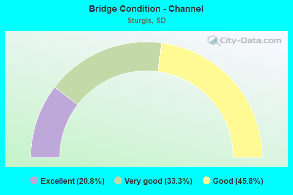
- Bridge Condition - Channel
- 20.8%Excellent
- 33.3%Very good
- 45.8%Good
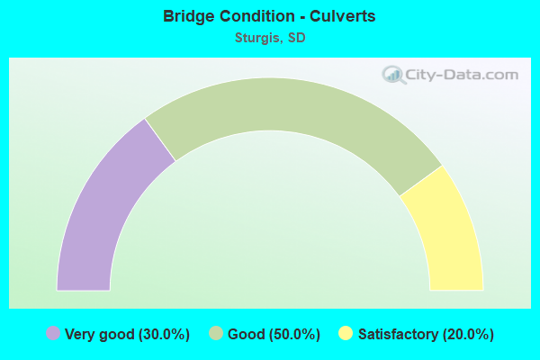
- Bridge Condition - Culverts
- 30.0%Very good
- 50.0%Good
- 20.0%Satisfactory
Find on map >> Show street view
Structure Number: 41228112, Location: 2.5 MI. SE WHITEWOOD (Lat: 44.443850, Lng: -103.590714), Route carried "on" structure: County highway , Year Built: 1938, Status: Posted for load, Structure Length: 1.52m (4.99ft), Average Daily Traffic: 335 (year 2019), Truck Traffic: 3%, Average Future Daily Traffic: 335 (year 2032), Design Load: HS 20+Mod, Features Intersected: SPRING CK, Facility Carried by Structure: I-90 SERVICE ROAD
Minimum Vertical Clearance: 30+ m (98+ ft), Kilometerpoint: 0.000, Lanes on structure: 2, Owner: County Highway Agency, Approaching Roadway Width: 7.3m (24.0ft), Material/Design: Steel, Design/Construction: Stringer/Multi-beam, Number Of Spans In Main Unit: 1, Length of Maximum Span: 14.6m (47.9ft), Curb-To-Curb Width: 7.9m (25.9ft), Out-to-Out Width: 8.8m (28.9ft)
Condition: Deck: Poor, Superstructure: Satisfactory, Substructure: Poor, Channel: Good, Operating Rating: 27.7 metric tons, Method Used To Determine Operating Rating: Load Factor (LF), Inventory Rating: 16.5 metric tons, Method Used To Determine Inventory Rating: Load Factor (LF), Structural Evaluation: Meets minimum limits, Deck Geometry: Somewhat better than minimum adequacy, Waterway Adequacy: Better than present minimum criteria, Approach Roadway Alignment: Better than present minimum criteria, Bridge Posting: Required (Relationship of Operating Rating to Maximum Legal Load: 10.0 - 19.9% below), Designated Inspection Frequency: Every 24 months, Inspection Date: July 2020, Deck Structure Type: Concrete Cast-file-Place, Wearing Surface/Protective System: Wearing Surface: Bituminous
Find on map >> Show street view
Structure Number: 41229111, Location: 3 SE SD 34 N INTERCH (Lat: 44.444347, Lng: -103.589881), Route carried "on" structure: Interstate 90, Year Built: 1968, Status: Open, Structure Length: 2.83m (9.28ft), Average Daily Traffic: 6,245 (year 2021), Truck Traffic: 14%, Average Future Daily Traffic: 9,630 (year 2041), Design Load: HS 20+Mod, Features Intersected: SPRING CK
Minimum Vertical Clearance: 30+ m (98+ ft), Kilometerpoint: 43.034, Lanes on structure: 2, Base Highway Network: Yes, Owner: State Highway Agency, Approaching Roadway Width: 11.6m (38.1ft), Material/Design: Concrete continuous, Design/Construction: Slab, Number Of Spans In Main Unit: 3, Length of Maximum Span: 10.0m (32.8ft), Curb-To-Curb Width: 11.6m (38.1ft), Out-to-Out Width: 12.4m (40.7ft)
Condition: Deck: Fair, Superstructure: Satisfactory, Substructure: Good, Channel: Very good, Operating Rating: 69.8 metric tons, Method Used To Determine Operating Rating: Load Factor (LF), Inventory Rating: 41.8 metric tons, Method Used To Determine Inventory Rating: Load Factor (LF), Structural Evaluation: Equal to present minimum criteria, Deck Geometry: Equal to present minimum criteria, Waterway Adequacy: Equal to present desirable criteria, Approach Roadway Alignment: Equal to present desirable criteria, Designated Inspection Frequency: Every 24 months, Inspection Date: January 2021, Deck Structure Type: Concrete Cast-file-Place, Wearing Surface/Protective System: Wearing Surface: Low Slump Concrete
Find on map >> Show street view
Structure Number: 41229112, Location: 3 SE SD 34 N INTERCH (Lat: 44.444100, Lng: -103.590222), Route carried "on" structure: Interstate 90, Year Built: 1967, Status: Open, Structure Length: 2.83m (9.28ft), Average Daily Traffic: 6,245 (year 2021), Truck Traffic: 14%, Average Future Daily Traffic: 9,630 (year 2041), Design Load: HS 20+Mod, Features Intersected: SPRING CK
Minimum Vertical Clearance: 30+ m (98+ ft), Kilometerpoint: 43.034, Lanes on structure: 2, Base Highway Network: Yes, Owner: State Highway Agency, Approaching Roadway Width: 11.6m (38.1ft), Material/Design: Concrete continuous, Design/Construction: Slab, Number Of Spans In Main Unit: 3, Length of Maximum Span: 10.0m (32.8ft), Curb-To-Curb Width: 11.6m (38.1ft), Out-to-Out Width: 12.4m (40.7ft)
Condition: Deck: Fair, Superstructure: Satisfactory, Substructure: Good, Channel: Very good, Operating Rating: 69.6 metric tons, Method Used To Determine Operating Rating: Load Factor (LF), Inventory Rating: 41.7 metric tons, Method Used To Determine Inventory Rating: Load Factor (LF), Structural Evaluation: Equal to present minimum criteria, Deck Geometry: Equal to present minimum criteria, Waterway Adequacy: Equal to present desirable criteria, Approach Roadway Alignment: Equal to present desirable criteria, Designated Inspection Frequency: Every 24 months, Inspection Date: January 2021, Deck Structure Type: Concrete Cast-file-Place, Wearing Surface/Protective System: Wearing Surface: Low Slump Concrete
Find on map >> Show street view
Structure Number: 41231144, Location: 4.2 SW JCT 90/14A (Lat: 44.394681, Lng: -103.587731), Route carried "on" structure: Alternate US 14, Year Built: 1999, Status: Open, Structure Length: 0.67m (2.20ft), Average Daily Traffic: 6,404 (year 2021), Truck Traffic: 10%, Average Future Daily Traffic: 9,279 (year 2041), Design Load: HS 20+Mod, Features Intersected: DRAW
Minimum Vertical Clearance: 30+ m (98+ ft), Kilometerpoint: 78.520, Lanes on structure: 2, Owner: State Highway Agency, Approaching Roadway Width: 17.1m (56.1ft), Skew: 2 degrees, Material/Design: Concrete continuous, Design/Construction: Culvert, Number Of Spans In Main Unit: 2, Length of Maximum Span: 3.0m (9.8ft)
Condition: Channel: Excellent, Culverts: Good, Structural Evaluation: Better than present minimum criteria, Waterway Adequacy: Superior to present desirable criteria, Approach Roadway Alignment: Superior to present desirable criteria, Designated Inspection Frequency: Every 48 months, Inspection Date: January 2019
Find on map >> Show street view
Structure Number: 41233142, Location: 2.9 W I 90 INTERCH (Lat: 44.398739, Lng: -103.583969), Route carried "on" structure: Alternate US 14, Year Built: 1975, Status: Open, Structure Length: 1.04m (3.41ft), Average Daily Traffic: 6,404 (year 2021), Truck Traffic: 10%, Average Future Daily Traffic: 9,279 (year 2041), Design Load: HS 20, Features Intersected: BEAR BUTTE CK
Minimum Vertical Clearance: 30+ m (98+ ft), Kilometerpoint: 79.775, Lanes on structure: 2, Owner: State Highway Agency, Approaching Roadway Width: 9.8m (32.2ft), Skew: 1 degrees, Material/Design: Concrete, Design/Construction: Frame, Number Of Spans In Main Unit: 1, Length of Maximum Span: 9.5m (31.2ft), Curb-To-Curb Width: 11.0m (36.1ft), Out-to-Out Width: 11.8m (38.7ft)
Condition: Deck: Good, Superstructure: Good, Substructure: Good, Channel: Good, Operating Rating: 57.8 metric tons, Method Used To Determine Operating Rating: Load and Resistance Factor (LRFR), Inventory Rating: 44.7 metric tons, Method Used To Determine Inventory Rating: Load and Resistance Factor (LRFR), Structural Evaluation: Better than present minimum criteria, Deck Geometry: Meets minimum limits, Waterway Adequacy: Equal to present desirable criteria, Approach Roadway Alignment: Equal to present minimum criteria, Designated Inspection Frequency: Every 24 months, Inspection Date: June 2020, Deck Structure Type: Concrete Cast-file-Place, Wearing Surface/Protective System: Wearing Surface: Epoxy Overlay, Membrane: Epoxy
Find on map >> Show street view
Structure Number: 41234145, Location: 3.5 W I 90 INTERCH (Lat: 44.396469, Lng: -103.582039), Route carried "on" structure: Alternate US 14, Year Built: 2000, Status: Open, Structure Length: 2.30m (7.55ft), Average Daily Traffic: 6,404 (year 2021), Truck Traffic: 10%, Average Future Daily Traffic: 9,279 (year 2041), Design Load: HS 25 or greater, Features Intersected: BEAR BUTTE CK
Minimum Vertical Clearance: 30+ m (98+ ft), Kilometerpoint: 79.389, Lanes on structure: 2, Owner: State Highway Agency, Approaching Roadway Width: 12.7m (41.7ft), Skew: 4 degrees, Material/Design: Steel, Design/Construction: Stringer/Multi-beam, Number Of Spans In Main Unit: 1, Length of Maximum Span: 22.4m (73.5ft), Curb or Sidewalk Widths: Left: 0.4m (1.3ft), Right: 0.4m (1.3ft), Curb-To-Curb Width: 12.2m (40.0ft), Out-to-Out Width: 13.0m (42.7ft)
Condition: Deck: Satisfactory, Superstructure: Satisfactory, Substructure: Fair, Channel: Excellent, Operating Rating: 73.9 metric tons, Method Used To Determine Operating Rating: Load Factor (LF), Inventory Rating: 44.3 metric tons, Method Used To Determine Inventory Rating: Load Factor (LF), Structural Evaluation: Somewhat better than minimum adequacy, Deck Geometry: Somewhat better than minimum adequacy, Waterway Adequacy: Superior to present desirable criteria, Approach Roadway Alignment: Equal to present desirable criteria, Designated Inspection Frequency: Every 24 months, Inspection Date: July 2020, Deck Structure Type: Concrete Cast-file-Place, Wearing Surface/Protective System: Wearing Surface: Epoxy Overlay, Membrane: Epoxy, Deck Protection: Epoxy Coated Reinforcing
Find on map >> Show street view
Structure Number: 47002437, Location: 0.1 E LAWRENCE CO LINE (Lat: 44.406361, Lng: -103.565781), Route carried "on" structure: Alternate US 14, Year Built: 2000, Status: Open, Structure Length: 2.30m (7.55ft), Average Daily Traffic: 6,404 (year 2021), Truck Traffic: 10%, Average Future Daily Traffic: 9,279 (year 2041), Design Load: HS 25 or greater, Features Intersected: BEAR BUTTE CK
Minimum Vertical Clearance: 30+ m (98+ ft), Kilometerpoint: 81.562, Lanes on structure: 2, Owner: State Highway Agency, Approaching Roadway Width: 12.7m (41.7ft), Skew: 4 degrees, Material/Design: Steel, Design/Construction: Stringer/Multi-beam, Number Of Spans In Main Unit: 1, Length of Maximum Span: 22.4m (73.5ft), Curb or Sidewalk Widths: Left: 0.4m (1.3ft), Right: 0.4m (1.3ft), Curb-To-Curb Width: 12.2m (40.0ft), Out-to-Out Width: 13.0m (42.7ft)
Condition: Deck: Satisfactory, Superstructure: Satisfactory, Substructure: Satisfactory, Channel: Excellent, Operating Rating: 73.9 metric tons, Method Used To Determine Operating Rating: Load Factor (LF), Inventory Rating: 44.3 metric tons, Method Used To Determine Inventory Rating: Load Factor (LF), Structural Evaluation: Equal to present minimum criteria, Deck Geometry: Somewhat better than minimum adequacy, Waterway Adequacy: Equal to present desirable criteria, Approach Roadway Alignment: Better than present minimum criteria, Designated Inspection Frequency: Every 24 months, Inspection Date: June 2020, Deck Structure Type: Concrete Cast-file-Place, Wearing Surface/Protective System: Wearing Surface: Epoxy Overlay, Membrane: Epoxy, Deck Protection: Epoxy Coated Reinforcing
Find on map >> Show street view
Structure Number: 47009426, Location: WEST EDGE OF STURGIS (Lat: 44.422411, Lng: -103.551747), Route carried "on" structure: City street 7711, Year Built: 2006, Status: Open, Structure Length: 1.00m (3.28ft), Average Daily Traffic: 875 (year 2019), Truck Traffic: 5%, Average Future Daily Traffic: 1,105 (year 2032), Design Load: HS 20+Mod, Features Intersected: TRIB TO BEAR BUTTE CK, Facility Carried by Structure: WHITEWOOD RD
Minimum Vertical Clearance: 30+ m (98+ ft), Kilometerpoint: 0.000, Lanes on structure: 2, Owner: City or Municipal Highway Agency, Approaching Roadway Width: 11.0m (36.1ft), Material/Design: Concrete continuous, Design/Construction: Culvert, Number Of Spans In Main Unit: 3, Length of Maximum Span: 3.0m (9.8ft)
Condition: Channel: Very good, Culverts: Very good, Operating Rating: 32.7 metric tons, Method Used To Determine Operating Rating: Field evaluation and documented engineering judgment, Inventory Rating: 24.5 metric tons, Method Used To Determine Inventory Rating: Field evaluation and documented engineering judgment, Structural Evaluation: Equal to present minimum criteria, Waterway Adequacy: Equal to present desirable criteria, Approach Roadway Alignment: Equal to present desirable criteria, Designated Inspection Frequency: Every 48 months, Inspection Date: June 2018
Find on map >> Show street view
Structure Number: 47010424, Location: 1 W STURGIS (Lat: 44.423900, Lng: -103.549222), Route carried "on" structure: County highway , Year Built: 1963, Status: Open, Structure Length: 0.98m (3.22ft), Average Daily Traffic: 33 (year 2019), Truck Traffic: 2%, Average Future Daily Traffic: 33 (year 2032), Design Load: HS 20+Mod, Features Intersected: CK, Facility Carried by Structure: ALDER PL.
Minimum Vertical Clearance: 30+ m (98+ ft), Kilometerpoint: 0.000, Lanes on structure: 2, Owner: County Highway Agency, Approaching Roadway Width: 8.2m (26.9ft), Material/Design: Concrete, Design/Construction: Culvert, Number Of Spans In Main Unit: 3, Length of Maximum Span: 3.0m (9.8ft)
Condition: Channel: Good, Culverts: Good, Operating Rating: 94.1 metric tons, Method Used To Determine Operating Rating: Load Factor (LF), Inventory Rating: 56.3 metric tons, Method Used To Determine Inventory Rating: Load Factor (LF), Structural Evaluation: Better than present minimum criteria, Waterway Adequacy: Better than present minimum criteria, Approach Roadway Alignment: Equal to present desirable criteria, Length Of Structure Improvement: 1.59m (5.22ft), Designated Inspection Frequency: Every 48 months, Inspection Date: June 2020, Bridge Improvement Cost: $3,000, Roadway Improvement Cost: $10,000, Total Project Cost: $15,000, Wearing Surface/Protective System: Membrane: Preformed Fabric
Find on map >> Show street view
Structure Number: 47010426, Location: 1 E LAWRENCE CO LINE (Lat: 44.423403, Lng: -103.549417), Route carried "on" structure: Interstate 90, Year Built: 1963, Status: Open, Structure Length: 0.94m (3.08ft), Average Daily Traffic: 10,290 (year 2020), Truck Traffic: 18%, Average Future Daily Traffic: 14,478 (year 2040), Design Load: HS 20+Mod, Features Intersected: CK
Minimum Vertical Clearance: 30+ m (98+ ft), Kilometerpoint: 46.735, Lanes on structure: 4, Base Highway Network: Yes, Owner: State Highway Agency, Approaching Roadway Width: 23.2m (76.1ft), Skew: 20 degrees, Material/Design: Concrete continuous, Design/Construction: Culvert, Number Of Spans In Main Unit: 3, Length of Maximum Span: 3.0m (9.8ft)
Condition: Channel: Very good, Culverts: Satisfactory, Inventory Rating: 67.5 metric tons, Method Used To Determine Inventory Rating: Load Factor (LF), Structural Evaluation: Equal to present minimum criteria, Waterway Adequacy: Equal to present desirable criteria, Approach Roadway Alignment: Equal to present desirable criteria, Designated Inspection Frequency: Every 48 months, Inspection Date: March 2020
Find on map >> Show street view
Structure Number: 47014427, Location: WEST EDGE OF STURGIS (Lat: 44.419878, Lng: -103.542103), Route carried "on" structure: City street 6545, Year Built: 2006, Status: Open, Structure Length: 3.05m (10.01ft), Average Daily Traffic: 875 (year 2019), Truck Traffic: 5%, Average Future Daily Traffic: 1,105 (year 2032), Design Load: HS 20+Mod, Features Intersected: BEAR BUTTE CK, Facility Carried by Structure: WHITEWOOD RD
Minimum Vertical Clearance: 30+ m (98+ ft), Kilometerpoint: 0.000, Lanes on structure: 2, Owner: City or Municipal Highway Agency, Approaching Roadway Width: 12.2m (40.0ft), Skew: 4 degrees, Material/Design: Concrete continuous, Design/Construction: Slab, Number Of Spans In Main Unit: 3, Length of Maximum Span: 10.6m (34.8ft), Curb-To-Curb Width: 12.2m (40.0ft), Out-to-Out Width: 13.0m (42.7ft)
Condition: Deck: Good, Superstructure: Good, Substructure: Satisfactory, Channel: Good, Operating Rating: 57.4 metric tons, Method Used To Determine Operating Rating: Load Factor (LF), Inventory Rating: 34.4 metric tons, Method Used To Determine Inventory Rating: Load Factor (LF), Structural Evaluation: Equal to present minimum criteria, Deck Geometry: Equal to present desirable criteria, Waterway Adequacy: Superior to present desirable criteria, Approach Roadway Alignment: Superior to present desirable criteria, Designated Inspection Frequency: Every 24 months, Inspection Date: June 2020, Deck Structure Type: Concrete Cast-file-Place, Wearing Surface/Protective System: Wearing Surface: Monolithic Concrete, Deck Protection: Epoxy Coated Reinforcing
Find on map >> Show street view
Structure Number: 47015425, Location: 0.5 W STURGIS (Lat: 44.421675, Lng: -103.539589), Route carried "on" structure: County highway , Year Built: 1963, Status: Posted for load, Structure Length: 3.23m (10.60ft), Average Daily Traffic: 33 (year 2019), Truck Traffic: 2%, Average Future Daily Traffic: 33 (year 2032), Design Load: HS 20, Features Intersected: CK, Facility Carried by Structure: AVALANCH RD.
Minimum Vertical Clearance: 30+ m (98+ ft), Kilometerpoint: 0.000, Lanes on structure: 2, Owner: County Highway Agency, Approaching Roadway Width: 7.3m (24.0ft), Material/Design: Concrete continuous, Design/Construction: Slab, Number Of Spans In Main Unit: 5, Length of Maximum Span: 5.5m (18.0ft), Curb-To-Curb Width: 7.3m (24.0ft), Out-to-Out Width: 7.3m (24.0ft)
Condition: Deck: Good, Superstructure: Good, Substructure: Good, Channel: Very good, Operating Rating: 36.6 metric tons, Method Used To Determine Operating Rating: Load Factor (LF), Inventory Rating: 21.9 metric tons, Method Used To Determine Inventory Rating: Load Factor (LF), Structural Evaluation: Equal to present minimum criteria, Deck Geometry: Equal to present minimum criteria, Waterway Adequacy: Equal to present desirable criteria, Approach Roadway Alignment: Equal to present desirable criteria, Length Of Structure Improvement: 3.60m (11.81ft), Designated Inspection Frequency: Every 24 months, Inspection Date: June 2020, Bridge Improvement Cost: $5,000, Roadway Improvement Cost: $10,000, Total Project Cost: $15,000, Deck Structure Type: Concrete Cast-file-Place, Wearing Surface/Protective System: Wearing Surface: Other
Find on map >> Show street view
Structure Number: 47015426, Location: 0.4 W US 14A INTERCH (Lat: 44.421392, Lng: -103.539714), Route carried "on" structure: Interstate 90, Year Built: 1963, Status: Open, Structure Length: 3.57m (11.71ft), Average Daily Traffic: 6,245 (year 2021), Truck Traffic: 14%, Average Future Daily Traffic: 9,855 (year 2041), Design Load: HS 20+Mod, Features Intersected: BEAR BUTTE CK
Minimum Vertical Clearance: 30+ m (98+ ft), Kilometerpoint: 48.023, Lanes on structure: 2, Base Highway Network: Yes, Owner: State Highway Agency, Approaching Roadway Width: 11.6m (38.1ft), Material/Design: Concrete continuous, Design/Construction: Slab, Number Of Spans In Main Unit: 5, Length of Maximum Span: 7.1m (23.3ft), Curb-To-Curb Width: 12.2m (40.0ft), Out-to-Out Width: 13.5m (44.3ft)
Condition: Deck: Good, Superstructure: Good, Substructure: Good, Channel: Good, Operating Rating: 41.8 metric tons, Method Used To Determine Operating Rating: Load Factor (LF), Inventory Rating: 25.0 metric tons, Method Used To Determine Inventory Rating: Load Factor (LF), Structural Evaluation: Equal to present minimum criteria, Deck Geometry: Better than present minimum criteria, Waterway Adequacy: Equal to present desirable criteria, Approach Roadway Alignment: Equal to present desirable criteria, Designated Inspection Frequency: Every 24 months, Inspection Date: August 2021, Deck Structure Type: Concrete Cast-file-Place, Wearing Surface/Protective System: Wearing Surface: Epoxy Overlay, Membrane: Epoxy
Find on map >> Show street view
Structure Number: 47015427, Location: 0.4 W US 14A INTERCH (Lat: 44.421175, Lng: -103.539822), Route carried "on" structure: Interstate 90, Year Built: 1963, Status: Open, Structure Length: 3.57m (11.71ft), Average Daily Traffic: 6,245 (year 2021), Truck Traffic: 14%, Average Future Daily Traffic: 9,855 (year 2041), Design Load: HS 20+Mod, Features Intersected: BEAR BUTTE CK
Minimum Vertical Clearance: 30+ m (98+ ft), Kilometerpoint: 48.023, Lanes on structure: 2, Base Highway Network: Yes, Owner: State Highway Agency, Approaching Roadway Width: 11.6m (38.1ft), Material/Design: Concrete continuous, Design/Construction: Slab, Number Of Spans In Main Unit: 5, Length of Maximum Span: 7.1m (23.3ft), Curb-To-Curb Width: 12.2m (40.0ft), Out-to-Out Width: 13.5m (44.3ft)
Condition: Deck: Satisfactory, Superstructure: Good, Substructure: Good, Channel: Good, Operating Rating: 63.8 metric tons, Method Used To Determine Operating Rating: Load Factor (LF), Inventory Rating: 38.2 metric tons, Method Used To Determine Inventory Rating: Load Factor (LF), Structural Evaluation: Better than present minimum criteria, Deck Geometry: Better than present minimum criteria, Waterway Adequacy: Equal to present desirable criteria, Approach Roadway Alignment: Equal to present desirable criteria, Designated Inspection Frequency: Every 24 months, Inspection Date: August 2021, Deck Structure Type: Concrete Cast-file-Place, Wearing Surface/Protective System: Wearing Surface: Epoxy Overlay, Membrane: Epoxy
Find on map >> Show street view
Structure Number: 47018428, Location: EXIT 30 US14A/SD34 INTERC (Lat: 44.418678, Lng: -103.531925), Route carried "on" structure: Interstate 90, Year Built: 1963, Status: Open, Structure Length: 5.55m (18.21ft), Average Daily Traffic: 8,855 (year 2021), Truck Traffic: 13%, Average Future Daily Traffic: 13,973 (year 2041), Design Load: HS 20+Mod, Features Intersected: US014A
Minimum Vertical Clearance: 30+ m (98+ ft), Kilometerpoint: 48.731, Lanes on structure: 2, Lanes under structure: 4, Base Highway Network: Yes, Owner: State Highway Agency, Approaching Roadway Width: 11.6m (38.1ft), Skew: 2 degrees, Material/Design: Concrete continuous, Design/Construction: Slab, Number Of Spans In Main Unit: 4, Length of Maximum Span: 14.5m (47.6ft), Curb-To-Curb Width: 11.6m (38.1ft), Out-to-Out Width: 12.6m (41.3ft)
Condition: Deck: Fair, Superstructure: Satisfactory, Substructure: Good, Operating Rating: 67.8 metric tons, Method Used To Determine Operating Rating: Load Factor (LF), Inventory Rating: 40.6 metric tons, Method Used To Determine Inventory Rating: Load Factor (LF), Structural Evaluation: Equal to present minimum criteria, Deck Geometry: Equal to present minimum criteria, Underclear: Equal to present minimum criteria, Approach Roadway Alignment: Better than present minimum criteria, Length Of Structure Improvement: 5.85m (19.19ft), Designated Inspection Frequency: Every 24 months, Inspection Date: December 2021, Bridge Improvement Cost: $512,000, Roadway Improvement Cost: $51,000, Total Project Cost: $718,000, Deck Structure Type: Concrete Cast-file-Place, Wearing Surface/Protective System: Wearing Surface: Epoxy Overlay, Membrane: Epoxy
Find on map >> Show street view
Structure Number: 4701843, Location: EXIT 30 US14A INTERCHANGE (Lat: 44.418578, Lng: -103.532236), Route carried "on" structure: Interstate 90, Year Built: 1963, Status: Open, Structure Length: 5.55m (18.21ft), Average Daily Traffic: 8,855 (year 2021), Truck Traffic: 13%, Average Future Daily Traffic: 13,973 (year 2041), Design Load: HS 20+Mod, Features Intersected: US014A
Minimum Vertical Clearance: 30+ m (98+ ft), Kilometerpoint: 48.731, Lanes on structure: 2, Lanes under structure: 4, Base Highway Network: Yes, Owner: State Highway Agency, Approaching Roadway Width: 11.6m (38.1ft), Skew: 2 degrees, Material/Design: Concrete continuous, Design/Construction: Slab, Number Of Spans In Main Unit: 4, Length of Maximum Span: 14.5m (47.6ft), Curb-To-Curb Width: 9.1m (29.9ft), Out-to-Out Width: 10.5m (34.4ft)
Condition: Deck: Satisfactory, Superstructure: Satisfactory, Substructure: Satisfactory, Operating Rating: 67.3 metric tons, Method Used To Determine Operating Rating: Load Factor (LF), Inventory Rating: 40.3 metric tons, Method Used To Determine Inventory Rating: Load Factor (LF), Structural Evaluation: Equal to present minimum criteria, Deck Geometry: High priority of replacement, Underclear: Equal to present minimum criteria, Approach Roadway Alignment: Better than present minimum criteria, Length Of Structure Improvement: 5.85m (19.19ft), Designated Inspection Frequency: Every 24 months, Inspection Date: December 2021, Bridge Improvement Cost: $515,000, Roadway Improvement Cost: $52,000, Total Project Cost: $720,000, Deck Structure Type: Concrete Cast-file-Place, Wearing Surface/Protective System: Wearing Surface: Epoxy Overlay, Membrane: Epoxy
Find on map >> Show street view
Structure Number: 4701943, Location: 0.2 SE US 14A INTERCH (Lat: 44.416128, Lng: -103.529653), Route carried "on" structure: Interstate 90, Year Built: 1963, Status: Open, Structure Length: 6.95m (22.80ft), Average Daily Traffic: 8,855 (year 2021), Truck Traffic: 13%, Average Future Daily Traffic: 13,973 (year 2041), Design Load: HS 20+Mod, Features Intersected: CP/DM&E RR
Minimum Vertical Clearance: 30+ m (98+ ft), Kilometerpoint: 49.053, Lanes on structure: 2, Base Highway Network: Yes, Owner: State Highway Agency, Approaching Roadway Width: 11.6m (38.1ft), Skew: 4 degrees, Material/Design: Steel continuous, Design/Construction: Stringer/Multi-beam, Number Of Spans In Main Unit: 3, Length of Maximum Span: 26.2m (86.0ft), Curb-To-Curb Width: 12.2m (40.0ft), Out-to-Out Width: 13.5m (44.3ft)
Condition: Deck: Satisfactory, Superstructure: Fair, Substructure: Satisfactory, Operating Rating: 47.9 metric tons, Method Used To Determine Operating Rating: Load Factor (LF), Inventory Rating: 28.7 metric tons, Method Used To Determine Inventory Rating: Load Factor (LF), Structural Evaluation: Somewhat better than minimum adequacy, Deck Geometry: Better than present minimum criteria, Underclear: Better than present minimum criteria, Approach Roadway Alignment: Better than present minimum criteria, Designated Inspection Frequency: Every 24 months, Inspection Date: October 2021, Deck Structure Type: Concrete Cast-file-Place, Wearing Surface/Protective System: Wearing Surface: Epoxy Overlay, Membrane: Epoxy
Find on map >> Show street view
Structure Number: 47019431, Location: 0.2 SE US 14A INTERCH (Lat: 44.416225, Lng: -103.530072), Route carried "on" structure: Interstate 90, Year Built: 1963, Status: Open, Structure Length: 6.95m (22.80ft), Average Daily Traffic: 8,855 (year 2021), Truck Traffic: 13%, Average Future Daily Traffic: 13,973 (year 2041), Design Load: HS 20+Mod, Features Intersected: CP/DM&E RR
Minimum Vertical Clearance: 30+ m (98+ ft), Kilometerpoint: 49.053, Lanes on structure: 2, Base Highway Network: Yes, Owner: State Highway Agency, Approaching Roadway Width: 11.6m (38.1ft), Skew: 4 degrees, Material/Design: Steel continuous, Design/Construction: Stringer/Multi-beam, Number Of Spans In Main Unit: 3, Length of Maximum Span: 26.2m (86.0ft), Curb-To-Curb Width: 12.2m (40.0ft), Out-to-Out Width: 13.5m (44.3ft)
Condition: Deck: Satisfactory, Superstructure: Satisfactory, Substructure: Satisfactory, Operating Rating: 49.7 metric tons, Method Used To Determine Operating Rating: Load Factor (LF), Inventory Rating: 29.8 metric tons, Method Used To Determine Inventory Rating: Load Factor (LF), Structural Evaluation: Equal to present minimum criteria, Deck Geometry: Better than present minimum criteria, Underclear: Equal to present minimum criteria, Approach Roadway Alignment: Better than present minimum criteria, Designated Inspection Frequency: Every 24 months, Inspection Date: October 2021, Deck Structure Type: Concrete Cast-file-Place, Wearing Surface/Protective System: Wearing Surface: Epoxy Overlay, Membrane: Epoxy
Find on map >> Show street view
Structure Number: 47024427, Location: 9TH ST - STURGIS (Lat: 44.419567, Lng: -103.521136), Route carried "on" structure: City street , Year Built: 2019, Status: Open, Structure Length: 4.15m (13.62ft), Average Daily Traffic: 488 (year 2019), Truck Traffic: 5%, Average Future Daily Traffic: 488 (year 2032), Design Load: HL 93, Features Intersected: BEAR BUTTE CK, Facility Carried by Structure: NINTH STREET
Minimum Vertical Clearance: 30+ m (98+ ft), Kilometerpoint: 0.000, Lanes on structure: 2, Owner: City or Municipal Highway Agency, Approaching Roadway Width: 11.0m (36.1ft), Material/Design: Prestressed concrete, Design/Construction: Stringer/Multi-beam, Number Of Spans In Main Unit: 2, Length of Maximum Span: 20.7m (67.9ft), Curb or Sidewalk Widths: Left: 2.4m (7.9ft), Right: 0.0m, Curb-To-Curb Width: 11.0m (36.1ft), Out-to-Out Width: 14.5m (47.6ft)
Condition: Deck: Excellent, Superstructure: Excellent, Substructure: Excellent, Channel: Very good, Operating Rating: 65.8 metric tons, Method Used To Determine Operating Rating: Load and Resistance Factor (LRFR), Inventory Rating: 47.4 metric tons, Method Used To Determine Inventory Rating: Load and Resistance Factor (LRFR), Structural Evaluation: Superior to present desirable criteria, Deck Geometry: Better than present minimum criteria, Waterway Adequacy: Equal to present desirable criteria, Approach Roadway Alignment: Equal to present desirable criteria, Designated Inspection Frequency: Every 24 months, Inspection Date: June 2020, Deck Structure Type: Concrete Cast-file-Place, Wearing Surface/Protective System: Wearing Surface: Integral Concrete, Deck Protection: Epoxy Coated Reinforcing
Find on map >> Show street view
Structure Number: 47024429, Location: 0.6 E I 90 INTERCH (Lat: 44.416361, Lng: -103.521594), Route carried "on" structure: State highway 34, Year Built: 1964, Status: Posted for load, Structure Length: 0.62m (2.03ft), Average Daily Traffic: 8,587 (year 2021), Truck Traffic: 4%, Average Future Daily Traffic: 13,413 (year 2041), Design Load: HS 20, Features Intersected: DRAINAGE DITCH
Minimum Vertical Clearance: 30+ m (98+ ft), Kilometerpoint: 55.410, Lanes on structure: 4, Base Highway Network: Yes, Owner: State Highway Agency, Approaching Roadway Width: 15.9m (52.2ft), Material/Design: Concrete continuous, Design/Construction: Culvert, Number Of Spans In Main Unit: 2, Length of Maximum Span: 3.0m (9.8ft), Curb or Sidewalk Widths: Left: 1.7m (5.6ft), Right: 1.7m (5.6ft), Curb-To-Curb Width: 15.9m (52.2ft), Out-to-Out Width: 19.8m (65.0ft)
Condition: Channel: Good, Culverts: Satisfactory, Operating Rating: 39.6 metric tons, Method Used To Determine Operating Rating: Load Factor (LF), Inventory Rating: 23.7 metric tons, Method Used To Determine Inventory Rating: Load Factor (LF), Structural Evaluation: Somewhat better than minimum adequacy, Deck Geometry: Meets minimum limits, Waterway Adequacy: Equal to present desirable criteria, Approach Roadway Alignment: Equal to present desirable criteria, Designated Inspection Frequency: Every 24 months, Inspection Date: January 2022, Deck Structure Type: Concrete Cast-file-Place, Wearing Surface/Protective System: Wearing Surface: Epoxy Overlay, Membrane: Epoxy
Find on map >> Show street view
Structure Number: 47024438, Location: 0.9 NW STURGIS INTERCH (Lat: 44.403192, Lng: -103.520211), Route carried "on" structure: Interstate 90, Year Built: 1963, Status: Open, Structure Length: 3.35m (10.99ft), Average Daily Traffic: 8,855 (year 2021), Truck Traffic: 13%, Average Future Daily Traffic: 13,973 (year 2041), Design Load: H 20, Features Intersected: DOLAN CK RD (FAS)
Minimum Vertical Clearance: 30+ m (98+ ft), Kilometerpoint: 50.694, Lanes on structure: 2, Lanes under structure: 2, Base Highway Network: Yes, Owner: State Highway Agency, Approaching Roadway Width: 11.6m (38.1ft), Material/Design: Concrete continuous, Design/Construction: Slab, Number Of Spans In Main Unit: 3, Length of Maximum Span: 12.2m (40.0ft), Curb-To-Curb Width: 12.2m (40.0ft), Out-to-Out Width: 13.5m (44.3ft)
Condition: Deck: Satisfactory, Superstructure: Good, Substructure: Good, Operating Rating: 42.8 metric tons, Method Used To Determine Operating Rating: Load Testing, Inventory Rating: 25.7 metric tons, Method Used To Determine Inventory Rating: Load Factor (LF), Structural Evaluation: Equal to present minimum criteria, Deck Geometry: Better than present minimum criteria, Underclear: Meets minimum limits, Approach Roadway Alignment: Equal to present desirable criteria, Designated Inspection Frequency: Every 24 months, Inspection Date: November 2020, Deck Structure Type: Concrete Cast-file-Place, Wearing Surface/Protective System: Wearing Surface: Epoxy Overlay, Membrane: Epoxy
Find on map >> Show street view
Structure Number: 47024439, Location: 0.9 NW STURGIS INTERCH (Lat: 44.403061, Lng: -103.520492), Route carried "on" structure: Interstate 90, Year Built: 1963, Status: Open, Structure Length: 3.35m (10.99ft), Average Daily Traffic: 8,855 (year 2021), Truck Traffic: 13%, Average Future Daily Traffic: 13,973 (year 2041), Design Load: H 20, Features Intersected: DOLAN CK RD (FAS)
Minimum Vertical Clearance: 30+ m (98+ ft), Kilometerpoint: 50.694, Lanes on structure: 2, Lanes under structure: 2, Base Highway Network: Yes, Owner: State Highway Agency, Approaching Roadway Width: 11.6m (38.1ft), Material/Design: Concrete continuous, Design/Construction: Slab, Number Of Spans In Main Unit: 3, Length of Maximum Span: 12.2m (40.0ft), Curb-To-Curb Width: 12.2m (40.0ft), Out-to-Out Width: 13.5m (44.3ft)
Condition: Deck: Good, Superstructure: Good, Substructure: Good, Operating Rating: 42.8 metric tons, Method Used To Determine Operating Rating: Load Testing, Inventory Rating: 25.7 metric tons, Method Used To Determine Inventory Rating: Load Factor (LF), Structural Evaluation: Equal to present minimum criteria, Deck Geometry: Better than present minimum criteria, Underclear: Meets minimum limits, Approach Roadway Alignment: Equal to present desirable criteria, Designated Inspection Frequency: Every 24 months, Inspection Date: November 2020, Deck Structure Type: Concrete Cast-file-Place, Wearing Surface/Protective System: Wearing Surface: Epoxy Overlay, Membrane: Epoxy
Find on map >> Show street view
Structure Number: 47028443, Location: 0.3 NW STURGIS INTERCH (Lat: 44.397700, Lng: -103.512586), Route carried "on" structure: Interstate 90, Year Built: 1963, Status: Open, Structure Length: 3.57m (11.71ft), Average Daily Traffic: 8,855 (year 2021), Truck Traffic: 13%, Average Future Daily Traffic: 13,973 (year 2041), Design Load: HS 20+Mod, Features Intersected: DEADMAN GULCH
Minimum Vertical Clearance: 30+ m (98+ ft), Kilometerpoint: 51.563, Lanes on structure: 2, Base Highway Network: Yes, Owner: State Highway Agency, Approaching Roadway Width: 11.6m (38.1ft), Material/Design: Concrete continuous, Design/Construction: Slab, Number Of Spans In Main Unit: 5, Length of Maximum Span: 7.1m (23.3ft), Curb-To-Curb Width: 12.2m (40.0ft), Out-to-Out Width: 13.5m (44.3ft)
Condition: Deck: Satisfactory, Superstructure: Good, Substructure: Satisfactory, Channel: Good, Operating Rating: 41.8 metric tons, Method Used To Determine Operating Rating: Load Factor (LF), Inventory Rating: 25.0 metric tons, Method Used To Determine Inventory Rating: Load Factor (LF), Structural Evaluation: Equal to present minimum criteria, Deck Geometry: Better than present minimum criteria, Waterway Adequacy: Equal to present desirable criteria, Approach Roadway Alignment: Equal to present desirable criteria, Designated Inspection Frequency: Every 24 months, Inspection Date: November 2020, Deck Structure Type: Concrete Cast-file-Place, Wearing Surface/Protective System: Wearing Surface: Low Slump Concrete
Find on map >> Show street view
Structure Number: 47028444, Location: 0.3 NW STURGIS INTERCH (Lat: 44.397489, Lng: -103.512733), Route carried "on" structure: Interstate 90, Year Built: 1963, Status: Open, Structure Length: 3.57m (11.71ft), Average Daily Traffic: 8,855 (year 2021), Truck Traffic: 13%, Average Future Daily Traffic: 13,973 (year 2041), Design Load: HS 20+Mod, Features Intersected: DEADMAN GULCH
Minimum Vertical Clearance: 30+ m (98+ ft), Kilometerpoint: 51.563, Lanes on structure: 2, Base Highway Network: Yes, Owner: State Highway Agency, Approaching Roadway Width: 11.6m (38.1ft), Material/Design: Concrete continuous, Design/Construction: Slab, Number Of Spans In Main Unit: 5, Length of Maximum Span: 7.1m (23.3ft), Curb-To-Curb Width: 12.2m (40.0ft), Out-to-Out Width: 13.5m (44.3ft)
Condition: Deck: Satisfactory, Superstructure: Good, Substructure: Satisfactory, Channel: Good, Operating Rating: 41.8 metric tons, Method Used To Determine Operating Rating: Load Factor (LF), Inventory Rating: 25.0 metric tons, Method Used To Determine Inventory Rating: Load Factor (LF), Structural Evaluation: Equal to present minimum criteria, Deck Geometry: Better than present minimum criteria, Waterway Adequacy: Equal to present desirable criteria, Approach Roadway Alignment: Equal to present desirable criteria, Designated Inspection Frequency: Every 24 months, Inspection Date: November 2020, Deck Structure Type: Concrete Cast-file-Place, Wearing Surface/Protective System: Wearing Surface: Low Slump Concrete
Find on map >> Show street view
Structure Number: 47030429, Location: JUNCTION AVE - STURGIS (Lat: 44.417311, Lng: -103.509136), Route carried "on" structure: City street , Year Built: 1998, Status: Open, Structure Length: 5.06m (16.60ft), Average Daily Traffic: 800 (year 2019), Truck Traffic: 8%, Average Future Daily Traffic: 800 (year 2032), Design Load: HS 20+Mod, Features Intersected: BEAR BUTTE CK, Facility Carried by Structure: JUNCTION AVENUE
Minimum Vertical Clearance: 30+ m (98+ ft), Kilometerpoint: 0.000, Lanes on structure: 2, Owner: City or Municipal Highway Agency, Approaching Roadway Width: 10.8m (35.4ft), Material/Design: Concrete continuous, Design/Construction: Slab, Number Of Spans In Main Unit: 4, Length of Maximum Span: 14.0m (45.9ft), Curb or Sidewalk Widths: Left: 0.0m, Right: 1.5m (4.9ft), Curb-To-Curb Width: 11.0m (36.1ft), Out-to-Out Width: 11.8m (38.7ft)
Condition: Deck: Good, Superstructure: Good, Substructure: Good, Channel: Very good, Operating Rating: 66.7 metric tons, Method Used To Determine Operating Rating: Load Factor (LF), Inventory Rating: 40.0 metric tons, Method Used To Determine Inventory Rating: Load Factor (LF), Structural Evaluation: Better than present minimum criteria, Deck Geometry: Better than present minimum criteria, Waterway Adequacy: Superior to present desirable criteria, Approach Roadway Alignment: Superior to present desirable criteria, Designated Inspection Frequency: Every 24 months, Inspection Date: June 2020, Deck Structure Type: Concrete Cast-file-Place, Wearing Surface/Protective System: Wearing Surface: Monolithic Concrete, Deck Protection: Epoxy Coated Reinforcing
Find on map >> Show street view
Structure Number: 47030443, Location: 0.1 NW STRGS INTERCHANGE (Lat: 44.396594, Lng: -103.508511), Route carried "on" structure: Interstate 90, Year Built: 2005, Status: Open, Structure Length: 8.18m (26.84ft), Average Daily Traffic: 10,325 (year 2021), Truck Traffic: 11%, Average Future Daily Traffic: 16,293 (year 2041), Design Load: HS 25 or greater, Features Intersected: VANOCKER CANYON, CP/DM&E
Minimum Vertical Clearance: 30+ m (98+ ft), Kilometerpoint: 51.934, Lanes on structure: 3, Lanes under structure: 2, Base Highway Network: Yes, Owner: State Highway Agency, Approaching Roadway Width: 13.4m (44.0ft), Skew: 2 degrees, Material/Design: Steel continuous, Design/Construction: Stringer/Multi-beam, Number Of Spans In Main Unit: 4, Length of Maximum Span: 21.8m (71.5ft), Curb-To-Curb Width: 14.0m (45.9ft), Out-to-Out Width: 14.8m (48.6ft)
Condition: Deck: Satisfactory, Superstructure: Satisfactory, Substructure: Good, Operating Rating: 79.6 metric tons, Method Used To Determine Operating Rating: Load Factor (LF), Inventory Rating: 47.7 metric tons, Method Used To Determine Inventory Rating: Load Factor (LF), Structural Evaluation: Equal to present minimum criteria, Deck Geometry: Meets minimum limits, Underclear: Meets minimum limits, Approach Roadway Alignment: Superior to present desirable criteria, Designated Inspection Frequency: Every 24 months, Inspection Date: August 2020, Deck Structure Type: Concrete Cast-file-Place, Wearing Surface/Protective System: Wearing Surface: Integral Concrete, Membrane: Epoxy, Deck Protection: Epoxy Coated Reinforcing
Find on map >> Show street view
Structure Number: 47030444, Location: 0.1 NW STRGS INTERCHANGE (Lat: 44.396328, Lng: -103.508453), Route carried "on" structure: Interstate 90, Year Built: 2006, Status: Open, Structure Length: 8.18m (26.84ft), Average Daily Traffic: 10,325 (year 2021), Truck Traffic: 11%, Average Future Daily Traffic: 16,293 (year 2041), Design Load: HS 25 or greater, Features Intersected: VANOCKER CANYON, CP/DM&E
Minimum Vertical Clearance: 30+ m (98+ ft), Kilometerpoint: 51.934, Lanes on structure: 3, Lanes under structure: 2, Base Highway Network: Yes, Owner: State Highway Agency, Approaching Roadway Width: 13.4m (44.0ft), Skew: 2 degrees, Material/Design: Steel continuous, Design/Construction: Stringer/Multi-beam, Number Of Spans In Main Unit: 4, Length of Maximum Span: 21.8m (71.5ft), Curb-To-Curb Width: 14.0m (45.9ft), Out-to-Out Width: 14.8m (48.6ft)
Condition: Deck: Satisfactory, Superstructure: Satisfactory, Substructure: Good, Operating Rating: 79.6 metric tons, Method Used To Determine Operating Rating: Load Factor (LF), Inventory Rating: 47.7 metric tons, Method Used To Determine Inventory Rating: Load Factor (LF), Structural Evaluation: Equal to present minimum criteria, Deck Geometry: Meets minimum limits, Underclear: Meets minimum limits, Approach Roadway Alignment: Superior to present desirable criteria, Designated Inspection Frequency: Every 24 months, Inspection Date: August 2020, Deck Structure Type: Concrete Cast-file-Place, Wearing Surface/Protective System: Wearing Surface: Integral Concrete, Membrane: Epoxy, Deck Protection: Epoxy Coated Reinforcing
Find on map >> Show street view
Structure Number: 47031438, Location: FULTON ST - STURGIS (Lat: 44.404136, Lng: -103.506100), Route carried "on" structure: City street , Year Built: 1979, Status: Open, Structure Length: 0.75m (2.46ft), Average Daily Traffic: 50 (year 2019), Truck Traffic: 5%, Average Future Daily Traffic: 50 (year 2032), Design Load: HS 20, Features Intersected: DEADMAN GULCH, Facility Carried by Structure: FULTON STREET
Minimum Vertical Clearance: 30+ m (98+ ft), Kilometerpoint: 0.000, Lanes on structure: 2, Owner: City or Municipal Highway Agency, Approaching Roadway Width: 11.0m (36.1ft), Skew: 3 degrees, Material/Design: Concrete, Design/Construction: Culvert, Number Of Spans In Main Unit: 1, Length of Maximum Span: 5.5m (18.0ft)
Condition: Channel: Good, Culverts: Good, Operating Rating: 43.1 metric tons, Method Used To Determine Operating Rating: Load Factor (LF), Inventory Rating: 25.8 metric tons, Method Used To Determine Inventory Rating: Load Factor (LF), Structural Evaluation: Equal to present minimum criteria, Waterway Adequacy: Superior to present desirable criteria, Approach Roadway Alignment: Better than present minimum criteria, Designated Inspection Frequency: Every 24 months, Inspection Date: June 2020
Find on map >> Show street view
Structure Number: 47031439, Location: MARSHALL ST - STURGIS (Lat: 44.403386, Lng: -103.507739), Route carried "on" structure: City street , Year Built: 1979, Status: Open, Structure Length: 0.69m (2.26ft), Average Daily Traffic: 50 (year 2019), Truck Traffic: 5%, Average Future Daily Traffic: 50 (year 2032), Design Load: HS 20, Features Intersected: DEADMAN GULCH, Facility Carried by Structure: MARSHALL STREET
Minimum Vertical Clearance: 30+ m (98+ ft), Kilometerpoint: 0.000, Lanes on structure: 2, Owner: City or Municipal Highway Agency, Approaching Roadway Width: 7.3m (24.0ft), Skew: 3 degrees, Material/Design: Concrete, Design/Construction: Culvert, Number Of Spans In Main Unit: 1, Length of Maximum Span: 5.5m (18.0ft)
Condition: Channel: Good, Culverts: Good, Operating Rating: 41.9 metric tons, Method Used To Determine Operating Rating: Load Factor (LF), Inventory Rating: 25.1 metric tons, Method Used To Determine Inventory Rating: Load Factor (LF), Structural Evaluation: Equal to present minimum criteria, Waterway Adequacy: Superior to present desirable criteria, Approach Roadway Alignment: Better than present minimum criteria, Designated Inspection Frequency: Every 24 months, Inspection Date: June 2020
Find on map >> Show street view
Structure Number: 47032429, Location: 200' N INT OF SLY/DUDLEY (Lat: 44.417078, Lng: -103.509139), Route carried "on" structure: City street , Year Built: 2013, Status: Open, Structure Length: 1.81m (5.94ft), Average Daily Traffic: 400 (year 2019), Truck Traffic: 5%, Average Future Daily Traffic: 400 (year 2034), Design Load: HL 93, Features Intersected: BEAR BUTTE CK, Facility Carried by Structure: SLY STREET
Minimum Vertical Clearance: 30+ m (98+ ft), Kilometerpoint: 0.000, Lanes on structure: 2, Owner: City or Municipal Highway Agency, Approaching Roadway Width: 6.9m (22.6ft), Material/Design: Steel, Design/Construction: Culvert, Number Of Spans In Main Unit: 6, Length of Maximum Span: 2.0m (6.6ft), Curb or Sidewalk Widths: Left: 2.1m (6.9ft), Right: 2.0m (6.6ft)
Condition: Channel: Very good, Culverts: Good, Operating Rating: 36.9 metric tons, Method Used To Determine Operating Rating: Load and Resistance Factor (LRFR), Inventory Rating: 24.5 metric tons, Method Used To Determine Inventory Rating: Load and Resistance Factor (LRFR), Structural Evaluation: Equal to present minimum criteria, Waterway Adequacy: Equal to present desirable criteria, Approach Roadway Alignment: Better than present minimum criteria, Designated Inspection Frequency: Every 24 months, Inspection Date: June 2020
Find on map >> Show street view
Structure Number: 47033444, Location: STURGIS INTERCHANGE (Lat: 44.395353, Lng: -103.503675), Route carried "on" structure: Interstate 90, Year Built: 2005, Status: Open, Structure Length: 6.83m (22.41ft), Average Daily Traffic: 10,325 (year 2021), Truck Traffic: 11%, Average Future Daily Traffic: 16,293 (year 2041), Design Load: HS 25 or greater, Features Intersected: JUNCTION AVE - STURGIS
Minimum Vertical Clearance: 30+ m (98+ ft), Kilometerpoint: 52.159, Lanes on structure: 2, Lanes under structure: 4, Base Highway Network: Yes, Owner: State Highway Agency, Approaching Roadway Width: 11.6m (38.1ft), Skew: 3 degrees, Material/Design: Steel continuous, Design/Construction: Stringer/Multi-beam, Number Of Spans In Main Unit: 3, Length of Maximum Span: 29.7m (97.4ft), Curb-To-Curb Width: 12.2m (40.0ft), Out-to-Out Width: 13.0m (42.7ft)
Condition: Deck: Satisfactory, Superstructure: Satisfactory, Substructure: Good, Operating Rating: 73.2 metric tons, Method Used To Determine Operating Rating: Load Factor (LF), Inventory Rating: 43.8 metric tons, Method Used To Determine Inventory Rating: Load Factor (LF), Structural Evaluation: Equal to present minimum criteria, Deck Geometry: Better than present minimum criteria, Underclear: Superior to present desirable criteria, Approach Roadway Alignment: Superior to present desirable criteria, Designated Inspection Frequency: Every 24 months, Inspection Date: August 2020, Deck Structure Type: Concrete Cast-file-Place, Wearing Surface/Protective System: Wearing Surface: Integral Concrete, Membrane: Epoxy, Deck Protection: Epoxy Coated Reinforcing
Find on map >> Show street view
Structure Number: 47033445, Location: STURGIS INTERCHANGE (Lat: 44.395064, Lng: -103.503597), Route carried "on" structure: Interstate 90, Year Built: 2006, Status: Open, Structure Length: 6.83m (22.41ft), Average Daily Traffic: 10,325 (year 2021), Truck Traffic: 11%, Average Future Daily Traffic: 16,293 (year 2041), Design Load: HS 25 or greater, Features Intersected: JUNCTION AVE - STURGIS
Minimum Vertical Clearance: 30+ m (98+ ft), Kilometerpoint: 52.159, Lanes on structure: 2, Lanes under structure: 4, Base Highway Network: Yes, Owner: State Highway Agency, Approaching Roadway Width: 11.6m (38.1ft), Skew: 3 degrees, Material/Design: Steel continuous, Design/Construction: Stringer/Multi-beam, Number Of Spans In Main Unit: 3, Length of Maximum Span: 29.7m (97.4ft), Curb-To-Curb Width: 12.2m (40.0ft), Out-to-Out Width: 13.0m (42.7ft)
Condition: Deck: Satisfactory, Superstructure: Satisfactory, Substructure: Good, Operating Rating: 73.2 metric tons, Method Used To Determine Operating Rating: Load Factor (LF), Inventory Rating: 43.8 metric tons, Method Used To Determine Inventory Rating: Load Factor (LF), Structural Evaluation: Equal to present minimum criteria, Deck Geometry: Better than present minimum criteria, Underclear: Equal to present minimum criteria, Approach Roadway Alignment: Superior to present desirable criteria, Designated Inspection Frequency: Every 24 months, Inspection Date: August 2020, Deck Structure Type: Concrete Cast-file-Place, Wearing Surface/Protective System: Wearing Surface: Integral Concrete, Membrane: Epoxy, Deck Protection: Epoxy Coated Reinforcing
Find on map >> Show street view
Structure Number: 47033449, Location: 0.5S EXIT 32 - STURGIS (Lat: 44.385822, Lng: -103.504200), Route carried "on" structure: City street , Year Built: 2005, Status: Open, Structure Length: 0.83m (2.72ft), Average Daily Traffic: 1,500 (year 2019), Truck Traffic: 3%, Average Future Daily Traffic: 1,900 (year 2032), Design Load: HS 20+Mod, Features Intersected: VANOCKER CK, Facility Carried by Structure: VANOCKER CANYON RD
Minimum Vertical Clearance: 30+ m (98+ ft), Kilometerpoint: 0.000, Lanes on structure: 2, Owner: City or Municipal Highway Agency, Approaching Roadway Width: 11.0m (36.1ft), Skew: 4 degrees, Material/Design: Concrete continuous, Design/Construction: Culvert, Number Of Spans In Main Unit: 2, Length of Maximum Span: 4.0m (13.1ft)
Condition: Channel: Excellent, Culverts: Very good, Operating Rating: 32.7 metric tons, Method Used To Determine Operating Rating: Field evaluation and documented engineering judgment, Inventory Rating: 24.5 metric tons, Method Used To Determine Inventory Rating: Field evaluation and documented engineering judgment, Structural Evaluation: Equal to present minimum criteria, Waterway Adequacy: Superior to present desirable criteria, Approach Roadway Alignment: Superior to present desirable criteria, Designated Inspection Frequency: Every 24 months, Inspection Date: June 2020
Find on map >> Show street view
Structure Number: 47040395, Location: 3.5N & 1E STURGIS (Lat: 44.466992, Lng: -103.488289), Route carried "on" structure: County highway , Year Built: 2001, Status: Open, Structure Length: 1.36m (4.46ft), Average Daily Traffic: 80 (year 2019), Truck Traffic: 3%, Average Future Daily Traffic: 91 (year 2032), Design Load: HS 20+Mod, Features Intersected: SPRING CK, Facility Carried by Structure: BEAR BUTTE RD.
Minimum Vertical Clearance: 30+ m (98+ ft), Kilometerpoint: 0.000, Lanes on structure: 2, Owner: County Highway Agency, Approaching Roadway Width: 8.5m (27.9ft), Material/Design: Concrete, Design/Construction: Culvert, Number Of Spans In Main Unit: 3, Length of Maximum Span: 4.3m (14.1ft)
Condition: Channel: Excellent, Culverts: Very good, Operating Rating: 89.8 metric tons, Method Used To Determine Operating Rating: Field evaluation and documented engineering judgment, Inventory Rating: 89.8 metric tons, Method Used To Determine Inventory Rating: Field evaluation and documented engineering judgment, Structural Evaluation: Equal to present desirable criteria, Waterway Adequacy: Superior to present desirable criteria, Approach Roadway Alignment: Superior to present desirable criteria, Designated Inspection Frequency: Every 48 months, Inspection Date: June 2020
Find on map >> Show street view
Structure Number: 47018428, Location: EXIT 30 US14A/SD34 INTERC (Lat: 44.418678, Lng: -103.531925), Route carried "under" structure: Alternate US 14, Year Built: 1963, Structure Length: 0. m, Average Daily Traffic: 10,534 (year 2021), Truck Traffic: 5%, Features Intersected: US014A, Facility Carried by Structure: I090 W
Minimum Vertical Clearance: 6.20m (20.34ft), Kilometerpoint: 85.311, Lanes on structure: 2, Lanes under structure: 4, Material/Design: Concrete continuous, Design/Construction: Slab, Length of Maximum Span: 14.5m (47.6ft)
Find on map >> Show street view
Structure Number: 4701843, Location: EXIT 30 US14A INTERCHANGE (Lat: 44.418578, Lng: -103.532236), Route carried "under" structure: Alternate US 14, Year Built: 1963, Structure Length: 0. m, Average Daily Traffic: 10,534 (year 2021), Truck Traffic: 5%, Features Intersected: US014A, Facility Carried by Structure: I090 E
Minimum Vertical Clearance: 6.15m (20.18ft), Kilometerpoint: 85.263, Lanes on structure: 2, Lanes under structure: 4, Material/Design: Concrete continuous, Design/Construction: Slab, Length of Maximum Span: 14.5m (47.6ft)
Find on map >> Show street view
Structure Number: 47023432, Location: SHERMAN ST (Lat: 44.414719, Lng: -103.522222), Route carried "under" structure: City street , Year Built: 1914, Structure Length: 0. m, Average Daily Traffic: 1,539 (year 1997), Truck Traffic: 1%, Features Intersected: SHERMAN STREET, Facility Carried by Structure: CP/DM&E RR
Minimum Vertical Clearance: 5.00m (16.40ft), Kilometerpoint: 0.000, Lanes under structure: 2, Material/Design: Steel, Design/Construction: Stringer/Multi-beam, Length of Maximum Span: 18.9m (62.0ft)
Find on map >> Show street view
Structure Number: 47024438, Location: 0.9 NW STURGIS INTERCH (Lat: 44.403192, Lng: -103.520211), Route carried "under" structure: County highway , Year Built: 1963, Structure Length: 0. m, Average Daily Traffic: 1,250 (year 2020), Truck Traffic: 2%, Features Intersected: DOLAN CK RD (FAS), Facility Carried by Structure: I090 W
Minimum Vertical Clearance: 4.72m (15.49ft), Kilometerpoint: 0.000, Lanes on structure: 2, Lanes under structure: 2, Material/Design: Concrete continuous, Design/Construction: Slab, Length of Maximum Span: 12.2m (40.0ft)
Find on map >> Show street view
Structure Number: 47024439, Location: 0.9 NW STURGIS INTERCH (Lat: 44.403061, Lng: -103.520492), Route carried "under" structure: County highway , Year Built: 1963, Structure Length: 0. m, Average Daily Traffic: 1,250 (year 2020), Truck Traffic: 2%, Features Intersected: DOLAN CK RD (FAS), Facility Carried by Structure: I090 E
Minimum Vertical Clearance: 4.77m (15.65ft), Kilometerpoint: 0.000, Lanes on structure: 2, Lanes under structure: 2, Material/Design: Concrete continuous, Design/Construction: Slab, Length of Maximum Span: 12.2m (40.0ft)
Find on map >> Show street view
Structure Number: 47026433, Location: FIFTH ST (Lat: 44.411522, Lng: -103.517411), Route carried "under" structure: City street , Year Built: 1989, Structure Length: 0. m, Average Daily Traffic: 2,000 (year 1997), Truck Traffic: 1%, Features Intersected: FIFTH STREET, Facility Carried by Structure: CP/DM&E RR
Minimum Vertical Clearance: 5.11m (16.77ft), Kilometerpoint: 0.000, Lanes under structure: 2, Material/Design: Steel, Design/Construction: Stringer/Multi-beam, Length of Maximum Span: 24.8m (81.4ft)
Find on map >> Show street view
Structure Number: 47030443, Location: 0.1 NW STRGS INTERCHANGE (Lat: 44.396594, Lng: -103.508511), Route carried "under" structure: County highway , Year Built: 2005, Structure Length: 0. m, Average Daily Traffic: 7,729 (year 2020), Truck Traffic: 3%, Features Intersected: VANOCKER CANYON, CP/DM&E, Facility Carried by Structure: I090 W
Minimum Vertical Clearance: 7.42m (24.34ft), Kilometerpoint: 0.000, Lanes on structure: 3, Lanes under structure: 2, Material/Design: Steel continuous, Design/Construction: Stringer/Multi-beam, Length of Maximum Span: 21.8m (71.5ft)
Find on map >> Show street view
Structure Number: 47030444, Location: 0.1 NW STRGS INTERCHANGE (Lat: 44.396328, Lng: -103.508453), Route carried "under" structure: County highway , Year Built: 2006, Structure Length: 0. m, Average Daily Traffic: 7,729 (year 2020), Truck Traffic: 3%, Features Intersected: VANOCKER CANYON, CP/DM&E, Facility Carried by Structure: I090 E
Minimum Vertical Clearance: 7.39m (24.25ft), Kilometerpoint: 0.000, Lanes on structure: 3, Lanes under structure: 2, Material/Design: Steel continuous, Design/Construction: Stringer/Multi-beam, Length of Maximum Span: 21.8m (71.5ft)
Find on map >> Show street view
Structure Number: 47033444, Location: STURGIS INTERCHANGE (Lat: 44.395353, Lng: -103.503675), Route carried "under" structure: City street , Year Built: 2005, Structure Length: 0. m, Average Daily Traffic: 6,446 (year 2020), Truck Traffic: 4%, Features Intersected: JUNCTION AVE - STURGIS, Facility Carried by Structure: I090 W
Minimum Vertical Clearance: 5.49m (18.01ft), Kilometerpoint: 0.000, Lanes on structure: 2, Lanes under structure: 4, Material/Design: Steel continuous, Design/Construction: Stringer/Multi-beam, Length of Maximum Span: 29.7m (97.4ft)
Find on map >> Show street view
Structure Number: 47033445, Location: STURGIS INTERCHANGE (Lat: 44.395064, Lng: -103.503597), Route carried "under" structure: City street , Year Built: 2006, Structure Length: 0. m, Average Daily Traffic: 6,446 (year 2020), Truck Traffic: 4%, Features Intersected: JUNCTION AVE - STURGIS, Facility Carried by Structure: I090 E
Minimum Vertical Clearance: 5.13m (16.83ft), Kilometerpoint: 0.000, Lanes on structure: 2, Lanes under structure: 4, Material/Design: Steel continuous, Design/Construction: Stringer/Multi-beam, Length of Maximum Span: 29.7m (97.4ft)