Bridge Statistics for Sugar City, Idaho (ID)
Condition, Traffic, Stress, Structural Evaluation, Project Costs
- National Bridge Inventory (NBI) Statistics
- 21Number of bridges
- 135ft / 40.8mTotal length
- $5,724,000Total costs
- 55,380Total average daily traffic
- 4,499Total average daily truck traffic
- National Bridge Inventory (NBI) Registered Bridges for Sugar City
- No street view available for this location
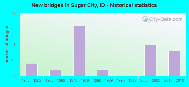
- New bridges - historical statistics
- 21950-1959
- 11960-1969
- 81970-1979
- 11980-1989
- 52000-2009
- 42010-2019


- Bridge Condition - Deck
- 16.7%Very good
- 27.8%Good
- 50.0%Satisfactory
- 5.6%Fair

- Bridge Condition - Superstructure
- 27.8%Very good
- 22.2%Good
- 38.9%Satisfactory
- 5.6%Fair
- 5.6%Poor

- Bridge Condition - Substructure
- 16.7%Very good
- 33.3%Good
- 33.3%Satisfactory
- 16.7%Fair

- Bridge Condition - Channel
- 58.8%Very good
- 29.4%Good
- 5.9%Satisfactory
- 5.9%Fair
Find on map >> Show street view
Structure Number: 12578, Location: IN SUGAR CITY (Lat: 43.875583, Lng: -111.757472), Route carried "on" structure: City street , Year Built: 2001, Status: Open, Structure Length: 6.16m (20.21ft), Average Daily Traffic: 1,900 (year 2019), Average Future Daily Traffic: 2,850 (year 2039), Design Load: HS 25 or greater, Features Intersected: US 20;SUGAR CITY HALF IC, Facility Carried by Structure: CENTER STREET
Minimum Vertical Clearance: 30+ m (98+ ft), Kilometerpoint: 161.280, Lanes on structure: 2, Lanes under structure: 4, Owner: State Highway Agency, Approaching Roadway Width: 17.1m (56.1ft), Material/Design: Prestressed concrete continuous, Design/Construction: Stringer/Multi-beam, Number Of Spans In Main Unit: 2, Length of Maximum Span: 29.9m (98.1ft), Curb or Sidewalk Widths: Left: 1.5m (4.9ft), Right: 0.0m, Curb-To-Curb Width: 14.8m (48.6ft), Out-to-Out Width: 17.5m (57.4ft)
Condition: Deck: Satisfactory, Superstructure: Good, Substructure: Satisfactory, Operating Rating: 93.4 metric tons, Method Used To Determine Operating Rating: Load Factor (LF), Inventory Rating: 49.9 metric tons, Method Used To Determine Inventory Rating: Load Factor (LF), Structural Evaluation: Equal to present minimum criteria, Deck Geometry: Superior to present desirable criteria, Underclear: Equal to present desirable criteria, Approach Roadway Alignment: Equal to present desirable criteria, Designated Inspection Frequency: Every 48 months, Inspection Date: September 2019, Deck Structure Type: Concrete Cast-file-Place, Wearing Surface/Protective System: Deck Protection: Epoxy Coated Reinforcing
Find on map >> Show street view
Structure Number: 12583, Location: 0.5 N. SUGAR CITY (Lat: 43.883700, Lng: -111.749950), Route carried "on" structure: Spur State highway 33, Year Built: 2001, Status: Open, Structure Length: 7.35m (24.11ft), Average Daily Traffic: 2,000 (year 2019), Truck Traffic: 10%, Average Future Daily Traffic: 3,000 (year 2039), Design Load: HS 25 or greater, Features Intersected: US 20;SH 33 SPUR IC
Minimum Vertical Clearance: 30+ m (98+ ft), Kilometerpoint: 159.968, Lanes on structure: 2, Lanes under structure: 4, Owner: State Highway Agency, Approaching Roadway Width: 15.5m (50.9ft), Skew: 3 degrees, Material/Design: Prestressed concrete continuous, Design/Construction: Stringer/Multi-beam, Number Of Spans In Main Unit: 2, Length of Maximum Span: 36.0m (118.1ft), Curb-To-Curb Width: 15.2m (49.9ft), Out-to-Out Width: 17.5m (57.4ft)
Condition: Deck: Good, Superstructure: Poor, Substructure: Satisfactory, Inventory Rating: 64.4 metric tons, Method Used To Determine Inventory Rating: Load Factor (LF), Structural Evaluation: Meets minimum limits, Deck Geometry: Superior to present desirable criteria, Underclear: Superior to present desirable criteria, Approach Roadway Alignment: Equal to present desirable criteria, Length Of Structure Improvement: 8.08m (26.51ft), Designated Inspection Frequency: Every 12 months, Inspection Date: September 2021, Bridge Improvement Cost: $2,500,000, Roadway Improvement Cost: $250,000, Total Project Cost: $3,750,000 ( Estimate for 2017), Deck Structure Type: Concrete Cast-file-Place, Wearing Surface/Protective System: Wearing Surface: Epoxy Overlay, Deck Protection: Epoxy Coated Reinforcing
Find on map >> Show street view
Structure Number: 12585, Location: 2.0 N. SUGAR CITY (Lat: 43.889694, Lng: -111.744139), Route carried "on" structure: US 20, Year Built: 1979, Status: Open, Structure Length: 3.08m (10.10ft), Average Daily Traffic: 6,000 (year 2019), Truck Traffic: 10%, Average Future Daily Traffic: 9,000 (year 2039), Design Load: HS 20, Features Intersected: N.FK.TETON RIVER
Minimum Vertical Clearance: 30+ m (98+ ft), Kilometerpoint: 546.218, Lanes on structure: 2, Base Highway Network: Yes (Inventory Route: US0, Subroute: 1), Owner: State Highway Agency, Approaching Roadway Width: 12.2m (40.0ft), Skew: 2 degrees, Material/Design: Prestressed concrete, Design/Construction: Stringer/Multi-beam, Number Of Spans In Main Unit: 1, Length of Maximum Span: 30.2m (99.1ft), Curb-To-Curb Width: 12.4m (40.7ft), Out-to-Out Width: 13.3m (43.6ft)
Condition: Deck: Satisfactory, Superstructure: Satisfactory, Substructure: Satisfactory, Channel: Very good, Operating Rating: 59.9 metric tons, Method Used To Determine Operating Rating: Load Factor (LF), Inventory Rating: 29.9 metric tons, Method Used To Determine Inventory Rating: Load Factor (LF), Structural Evaluation: Equal to present minimum criteria, Deck Geometry: Better than present minimum criteria, Waterway Adequacy: Equal to present desirable criteria, Approach Roadway Alignment: Equal to present desirable criteria, Designated Inspection Frequency: Every 24 months, Inspection Date: July 2021, Deck Structure Type: Concrete Cast-file-Place, Wearing Surface/Protective System: Wearing Surface: Latex Concrete
Find on map >> Show street view
Structure Number: 1259, Location: 2.0 N. SUGAR CITY (Lat: 43.889389, Lng: -111.743972), Route carried "on" structure: US 20, Year Built: 1979, Status: Open, Structure Length: 3.08m (10.10ft), Average Daily Traffic: 6,000 (year 2019), Truck Traffic: 10%, Average Future Daily Traffic: 9,000 (year 2039), Design Load: HS 20, Features Intersected: N.FK.TETON RIVER
Minimum Vertical Clearance: 30+ m (98+ ft), Kilometerpoint: 546.220, Lanes on structure: 2, Base Highway Network: Yes (Inventory Route: US0, Subroute: 1), Owner: State Highway Agency, Approaching Roadway Width: 12.2m (40.0ft), Skew: 2 degrees, Material/Design: Prestressed concrete, Design/Construction: Stringer/Multi-beam, Number Of Spans In Main Unit: 1, Length of Maximum Span: 30.2m (99.1ft), Curb-To-Curb Width: 12.4m (40.7ft), Out-to-Out Width: 13.3m (43.6ft)
Condition: Deck: Satisfactory, Superstructure: Good, Substructure: Satisfactory, Channel: Very good, Operating Rating: 59.9 metric tons, Method Used To Determine Operating Rating: Load Factor (LF), Inventory Rating: 29.9 metric tons, Method Used To Determine Inventory Rating: Load Factor (LF), Structural Evaluation: Equal to present minimum criteria, Deck Geometry: Better than present minimum criteria, Waterway Adequacy: Equal to present desirable criteria, Approach Roadway Alignment: Equal to present desirable criteria, Designated Inspection Frequency: Every 24 months, Inspection Date: July 2021, Deck Structure Type: Concrete Cast-file-Place, Wearing Surface/Protective System: Wearing Surface: Latex Concrete
Find on map >> Show street view
Structure Number: 20985, Location: 4.8 N. 0.6 E. REXBURG (Lat: 43.882361, Lng: -111.777861), Route carried "on" structure: County highway 6770, Year Built: 1976, Status: Open, Structure Length: 2.65m (8.69ft), Average Daily Traffic: 3,600 (year 2019), Truck Traffic: 10%, Average Future Daily Traffic: 5,400 (year 2039), Design Load: HS 20, Features Intersected: N.FK.TETON RIVER
Minimum Vertical Clearance: 30+ m (98+ ft), Kilometerpoint: 4.548, Lanes on structure: 2, Owner: County Highway Agency, Approaching Roadway Width: 9.1m (29.9ft), Skew: 1 degrees, Material/Design: Prestressed concrete, Design/Construction: Stringer/Multi-beam, Number Of Spans In Main Unit: 1, Length of Maximum Span: 25.9m (85.0ft), Curb-To-Curb Width: 10.6m (34.8ft), Out-to-Out Width: 11.5m (37.7ft)
Condition: Deck: Satisfactory, Superstructure: Good, Substructure: Good, Channel: Very good, Operating Rating: 44.5 metric tons, Method Used To Determine Operating Rating: Load Factor (LF), Inventory Rating: 27.2 metric tons, Method Used To Determine Inventory Rating: Load Factor (LF), Structural Evaluation: Equal to present minimum criteria, Deck Geometry: Somewhat better than minimum adequacy, Waterway Adequacy: Superior to present desirable criteria, Approach Roadway Alignment: Equal to present desirable criteria, Designated Inspection Frequency: Every 24 months, Inspection Date: April 2020, Deck Structure Type: Concrete Cast-file-Place, Wearing Surface/Protective System: Wearing Surface: Bituminous
Find on map >> Show street view
Structure Number: 20991, Location: 4.0 S. 1.0 W. PARKER (Lat: 43.901111, Lng: -111.777861), Route carried "on" structure: County highway 6770, Year Built: 2010, Status: Open, Structure Length: 0.98m (3.22ft), Average Daily Traffic: 2,500 (year 2019), Truck Traffic: 9%, Average Future Daily Traffic: 3,750 (year 2039), Design Load: HL 93, Features Intersected: CONSOLIDATED FARMERS CNL
Minimum Vertical Clearance: 30+ m (98+ ft), Kilometerpoint: 6.635, Lanes on structure: 2, Owner: County Highway Agency, Approaching Roadway Width: 12.2m (40.0ft), Skew: 1 degrees, Material/Design: Concrete, Design/Construction: Frame, Number Of Spans In Main Unit: 1, Length of Maximum Span: 9.8m (32.2ft), Curb-To-Curb Width: 11.8m (38.7ft), Out-to-Out Width: 12.6m (41.3ft)
Condition: Deck: Very good, Superstructure: Very good, Substructure: Good, Channel: Very good, Operating Rating: 84.4 metric tons, Method Used To Determine Operating Rating: Load Factor (LF), Inventory Rating: 50.8 metric tons, Method Used To Determine Inventory Rating: Load Factor (LF), Structural Evaluation: Better than present minimum criteria, Deck Geometry: Somewhat better than minimum adequacy, Waterway Adequacy: Equal to present desirable criteria, Approach Roadway Alignment: Better than present minimum criteria, Designated Inspection Frequency: Every 48 months, Inspection Date: October 2019, Deck Structure Type: Concrete Cast-file-Place, Wearing Surface/Protective System: Wearing Surface: Monolithic Concrete, Deck Protection: Epoxy Coated Reinforcing
Find on map >> Show street view
Structure Number: 2102, Location: 1.2 S. 0.7 E. SUGAR CITY (Lat: 43.854750, Lng: -111.734194), Route carried "on" structure: County highway 6774, Year Built: 1974, Status: Open, Structure Length: 0.70m (2.30ft), Average Daily Traffic: 1,400 (year 2019), Truck Traffic: 8%, Average Future Daily Traffic: 2,100 (year 2039), Design Load: HS 20, Features Intersected: S.FK.TETON R.OVERFLOW
Minimum Vertical Clearance: 30+ m (98+ ft), Kilometerpoint: 2.668, Lanes on structure: 2, Owner: County Highway Agency, Approaching Roadway Width: 8.5m (27.9ft), Material/Design: Concrete, Design/Construction: Frame, Number Of Spans In Main Unit: 1, Length of Maximum Span: 7.0m (23.0ft), Curb or Sidewalk Widths: Left: 0.3m (1.0ft), Right: 0.3m (1.0ft), Curb-To-Curb Width: 9.4m (30.8ft), Out-to-Out Width: 11.6m (38.1ft)
Condition: Deck: Satisfactory, Superstructure: Satisfactory, Substructure: Good, Channel: Good, Operating Rating: 68.0 metric tons, Method Used To Determine Operating Rating: Load Factor (LF), Inventory Rating: 40.8 metric tons, Method Used To Determine Inventory Rating: Load Factor (LF), Structural Evaluation: Equal to present minimum criteria, Deck Geometry: Somewhat better than minimum adequacy, Waterway Adequacy: Equal to present desirable criteria, Approach Roadway Alignment: Equal to present desirable criteria, Designated Inspection Frequency: Every 48 months, Underwater Inspection Frequency: Every 60 months, Inspection Date: October 2020, Underwater Inspection Date: October 2018, Deck Structure Type: Concrete Cast-file-Place, Wearing Surface/Protective System: Wearing Surface: Bituminous
Find on map >> Show street view
Structure Number: 21025, Location: 1.2 S. 1 E. SUGAR CITY (Lat: 43.854750, Lng: -111.728194), Route carried "on" structure: County highway 6774, Year Built: 1959, Status: Open, Structure Length: 2.13m (6.99ft), Average Daily Traffic: 1,400 (year 2019), Truck Traffic: 8%, Average Future Daily Traffic: 2,100 (year 2039), Design Load: H 15, Features Intersected: S.FK.TETON RIVER
Minimum Vertical Clearance: 30+ m (98+ ft), Kilometerpoint: 3.162, Lanes on structure: 2, Owner: County Highway Agency, Approaching Roadway Width: 6.7m (22.0ft), Material/Design: Concrete, Design/Construction: Stringer/Multi-beam, Number Of Spans In Main Unit: 2, Length of Maximum Span: 10.7m (35.1ft), Curb or Sidewalk Widths: Left: 0.3m (1.0ft), Right: 0.1m (0.3ft), Curb-To-Curb Width: 7.3m (24.0ft), Out-to-Out Width: 8.1m (26.6ft)
Condition: Deck: Fair, Superstructure: Satisfactory, Substructure: Fair, Channel: Fair, Operating Rating: 21.8 metric tons, Method Used To Determine Operating Rating: Load Factor (LF), Inventory Rating: 12.7 metric tons, Method Used To Determine Inventory Rating: Load Factor (LF), Structural Evaluation: Meets minimum limits, Deck Geometry: Meets minimum limits, Waterway Adequacy: Equal to present desirable criteria, Approach Roadway Alignment: Equal to present desirable criteria, Length Of Structure Improvement: 2.87m (9.42ft), Designated Inspection Frequency: Every 24 months, Underwater Inspection Frequency: Every 60 months, Inspection Date: April 2020, Underwater Inspection Date: October 2018, Bridge Improvement Cost: $527,000, Roadway Improvement Cost: $53,000, Total Project Cost: $791,000 ( Estimate for 2017), Deck Structure Type: Concrete Cast-file-Place, Wearing Surface/Protective System: Wearing Surface: Bituminous
Find on map >> Show street view
Structure Number: 31946, Location: 3.2 S. 3.7 W. ST ANTHONY (Lat: 43.913861, Lng: -111.757833), Route carried "on" structure: County highway , Year Built: 2018, Status: Open, Structure Length: 1.43m (4.69ft), Average Daily Traffic: 120 (year 2019), Truck Traffic: 10%, Average Future Daily Traffic: 180 (year 2039), Design Load: HL 93, Features Intersected: CONSOLIDATED FARMERS CNL, Facility Carried by Structure: N 2000 E
Minimum Vertical Clearance: 30+ m (98+ ft), Kilometerpoint: 162.666, Lanes on structure: 2, Owner: County Highway Agency, Approaching Roadway Width: 6.7m (22.0ft), Material/Design: Steel, Design/Construction: Stringer/Multi-beam, Number Of Spans In Main Unit: 1, Length of Maximum Span: 13.7m (44.9ft), Curb-To-Curb Width: 11.0m (36.1ft), Out-to-Out Width: 11.0m (36.1ft)
Condition: Deck: Very good, Superstructure: Very good, Substructure: Very good, Channel: Very good, Operating Rating: 45.7 metric tons, Method Used To Determine Operating Rating: Load and Resistance Factor Rating (LRFR) rating reported by rating factor(RF) method using HL-93 loadings, Inventory Rating: 35.3 metric tons, Method Used To Determine Inventory Rating: Load and Resistance Factor Rating (LRFR) rating reported by rating factor(RF) method using HL-93 loadings, Structural Evaluation: Equal to present desirable criteria, Deck Geometry: Equal to present desirable criteria, Waterway Adequacy: Superior to present desirable criteria, Approach Roadway Alignment: Better than present minimum criteria, Designated Inspection Frequency: Every 48 months, Inspection Date: November 2021, Deck Structure Type: Corrugated Steel, Wearing Surface/Protective System: Wearing Surface: Bituminous
Find on map >> Show street view
Structure Number: 3202, Location: 4.3 S. 4.9 W. ST ANTHONY (Lat: 43.898278, Lng: -111.779750), Route carried "on" structure: County highway , Year Built: 1976, Status: Open, Structure Length: 0.79m (2.59ft), Average Daily Traffic: 80 (year 2019), Truck Traffic: 10%, Average Future Daily Traffic: 120 (year 2039), Design Load: HS 20, Features Intersected: CONSOLIDATED FARMERS CNL, Facility Carried by Structure: E 100 N
Minimum Vertical Clearance: 30+ m (98+ ft), Kilometerpoint: 168.825, Lanes on structure: 2, Owner: County Highway Agency, Approaching Roadway Width: 7.3m (24.0ft), Skew: 3 degrees, Material/Design: Prestressed concrete, Design/Construction: Tee Beam, Number Of Spans In Main Unit: 1, Length of Maximum Span: 7.6m (24.9ft), Curb or Sidewalk Widths: Left: 0.2m (0.7ft), Right: 0.2m (0.7ft), Curb-To-Curb Width: 6.8m (22.3ft), Out-to-Out Width: 7.3m (24.0ft)
Condition: Deck: Good, Superstructure: Satisfactory, Substructure: Satisfactory, Channel: Good, Operating Rating: 27.2 metric tons, Method Used To Determine Operating Rating: Field evaluation and documented engineering judgment, Inventory Rating: 16.3 metric tons, Method Used To Determine Inventory Rating: Field evaluation and documented engineering judgment, Structural Evaluation: Somewhat better than minimum adequacy, Deck Geometry: Somewhat better than minimum adequacy, Waterway Adequacy: Equal to present desirable criteria, Approach Roadway Alignment: Equal to present desirable criteria, Length Of Structure Improvement: 1.40m (4.59ft), Designated Inspection Frequency: Every 24 months, Inspection Date: November 2021, Bridge Improvement Cost: $213,000, Roadway Improvement Cost: $21,000, Total Project Cost: $320,000 ( Estimate for 2021), Deck Structure Type: Concrete Cast-file-Place, Wearing Surface/Protective System: Wearing Surface: Bituminous
Find on map >> Show street view
Structure Number: 32023, Location: 2.0 N. 1.2 W. SUGAR CITY (Lat: 43.904897, Lng: -111.777750), Route carried "on" structure: County highway , Year Built: 2017, Status: Open, Structure Length: 1.34m (4.40ft), Average Daily Traffic: 130 (year 2019), Truck Traffic: 13%, Average Future Daily Traffic: 195 (year 2039), Design Load: HL 93, Features Intersected: SALEM CANAL, Facility Carried by Structure: HIGH TOP LANE
Minimum Vertical Clearance: 30+ m (98+ ft), Kilometerpoint: 160.944, Lanes on structure: 2, Owner: County Highway Agency, Approaching Roadway Width: 9.8m (32.2ft), Material/Design: Steel, Design/Construction: Stringer/Multi-beam, Number Of Spans In Main Unit: 1, Length of Maximum Span: 12.5m (41.0ft), Curb-To-Curb Width: 8.6m (28.2ft), Out-to-Out Width: 8.8m (28.9ft)
Condition: Deck: Very good, Superstructure: Very good, Substructure: Very good, Channel: Very good, Operating Rating: 41.1 metric tons, Method Used To Determine Operating Rating: Load and Resistance Factor Rating (LRFR) rating reported by rating factor(RF) method using HL-93 loadings, Inventory Rating: 31.8 metric tons, Method Used To Determine Inventory Rating: Load and Resistance Factor Rating (LRFR) rating reported by rating factor(RF) method using HL-93 loadings, Structural Evaluation: Better than present minimum criteria, Deck Geometry: Equal to present minimum criteria, Waterway Adequacy: Superior to present desirable criteria, Approach Roadway Alignment: Equal to present minimum criteria, Designated Inspection Frequency: Every 24 months, Inspection Date: April 2021, Deck Structure Type: Corrugated Steel, Wearing Surface/Protective System: Wearing Surface: Gravel
Find on map >> Show street view
Structure Number: 32795, Location: 0.4 S. 0.5 E. SUGAR CITY (Lat: 43.869111, Lng: -111.737972), Route carried "on" structure: County highway 6785, Year Built: 1959, Year Reconstructed: 1989, Status: Posted for load, Structure Length: 0.79m (2.59ft), Average Daily Traffic: 790 (year 2019), Average Future Daily Traffic: 1,185 (year 2039), Design Load: HS 20, Features Intersected: TETON ISLAND CANAL
Minimum Vertical Clearance: 30+ m (98+ ft), Kilometerpoint: 164.121, Lanes on structure: 2, Owner: County Highway Agency, Approaching Roadway Width: 9.1m (29.9ft), Skew: 1 degrees, Material/Design: Steel, Design/Construction: Stringer/Multi-beam, Number Of Spans In Main Unit: 1, Length of Maximum Span: 7.0m (23.0ft), Curb or Sidewalk Widths: Left: 0.0m, Right: 0.3m (1.0ft), Curb-To-Curb Width: 13.4m (44.0ft), Out-to-Out Width: 15.0m (49.2ft)
Condition: Deck: Satisfactory, Superstructure: Fair, Substructure: Fair, Channel: Satisfactory, Operating Rating: 22.7 metric tons, Method Used To Determine Operating Rating: Load Factor (LF), Inventory Rating: 13.6 metric tons, Method Used To Determine Inventory Rating: Load Factor (LF), Structural Evaluation: Meets minimum limits, Deck Geometry: Superior to present desirable criteria, Waterway Adequacy: Equal to present desirable criteria, Approach Roadway Alignment: Better than present minimum criteria, Bridge Posting: Required (Relationship of Operating Rating to Maximum Legal Load: 30.0 - 39.9% below), Length Of Structure Improvement: 1.40m (4.59ft), Designated Inspection Frequency: Every 24 months, Inspection Date: March 2021, Bridge Improvement Cost: $372,000, Roadway Improvement Cost: $37,000, Total Project Cost: $558,000 ( Estimate for 2016), Deck Structure Type: Concrete Cast-file-Place, Wearing Surface/Protective System: Wearing Surface: Bituminous
Find on map >> Show street view
Structure Number: 3281, Location: 4.4 N. 3.6 E. REXBURG (Lat: 43.890861, Lng: -111.717917), Route carried "on" structure: County highway , Year Built: 1977, Status: Open, Structure Length: 1.37m (4.49ft), Average Daily Traffic: 110 (year 2019), Truck Traffic: 10%, Average Future Daily Traffic: 165 (year 2039), Design Load: HS 20, Features Intersected: TETON ISLAND CANAL, Facility Carried by Structure: N 3000 E
Minimum Vertical Clearance: 30+ m (98+ ft), Kilometerpoint: 161.713, Lanes on structure: 2, Owner: County Highway Agency, Approaching Roadway Width: 8.5m (27.9ft), Material/Design: Prestressed concrete, Design/Construction: Slab, Number Of Spans In Main Unit: 1, Length of Maximum Span: 13.4m (44.0ft), Curb-To-Curb Width: 8.8m (28.9ft), Out-to-Out Width: 9.8m (32.2ft)
Condition: Deck: Good, Superstructure: Good, Substructure: Good, Channel: Very good, Operating Rating: 47.2 metric tons, Method Used To Determine Operating Rating: Field evaluation and documented engineering judgment, Inventory Rating: 28.1 metric tons, Method Used To Determine Inventory Rating: Field evaluation and documented engineering judgment, Structural Evaluation: Better than present minimum criteria, Deck Geometry: Equal to present minimum criteria, Waterway Adequacy: Equal to present desirable criteria, Approach Roadway Alignment: Equal to present desirable criteria, Designated Inspection Frequency: Every 24 months, Inspection Date: April 2021, Deck Structure Type: Concrete Cast-file-Place, Wearing Surface/Protective System: Wearing Surface: Bituminous
Find on map >> Show street view
Structure Number: 32831, Location: 4.2 N 1.6 E REXBURG (Lat: 43.887200, Lng: -111.758100), Route carried "on" structure: County highway , Year Built: 2015, Status: Open, Structure Length: 2.16m (7.09ft), Average Daily Traffic: 730 (year 2019), Truck Traffic: 7%, Average Future Daily Traffic: 1,095 (year 2039), Design Load: HL 93, Features Intersected: N. FK. TETON RIVER, Facility Carried by Structure: N. 1000 E. RD
Minimum Vertical Clearance: 30+ m (98+ ft), Kilometerpoint: 169.466, Lanes on structure: 2, Owner: County Highway Agency, Approaching Roadway Width: 8.5m (27.9ft), Material/Design: Prestressed concrete, Design/Construction: Stringer/Multi-beam, Number Of Spans In Main Unit: 1, Length of Maximum Span: 20.7m (67.9ft), Curb-To-Curb Width: 12.9m (42.3ft), Out-to-Out Width: 13.7m (44.9ft)
Condition: Deck: Good, Superstructure: Very good, Substructure: Very good, Channel: Very good, Operating Rating: 50.2 metric tons, Method Used To Determine Operating Rating: Load and Resistance Factor Rating (LRFR) rating reported by rating factor(RF) method using HL-93 loadings, Inventory Rating: 38.9 metric tons, Method Used To Determine Inventory Rating: Load and Resistance Factor Rating (LRFR) rating reported by rating factor(RF) method using HL-93 loadings, Structural Evaluation: Equal to present desirable criteria, Deck Geometry: Superior to present desirable criteria, Waterway Adequacy: Superior to present desirable criteria, Approach Roadway Alignment: Equal to present desirable criteria, Designated Inspection Frequency: Every 48 months, Inspection Date: April 2018, Deck Structure Type: Concrete Cast-file-Place, Wearing Surface/Protective System: Wearing Surface: Monolithic Concrete, Deck Protection: Epoxy Coated Reinforcing
Find on map >> Show street view
Structure Number: 32855, Location: IN SUGAR CITY;3RD N.ST (Lat: 43.876500, Lng: -111.750583), Route carried "on" structure: County highway , Year Built: 1978, Status: Open, Structure Length: 0.70m (2.30ft), Average Daily Traffic: 260 (year 2019), Truck Traffic: 12%, Average Future Daily Traffic: 390 (year 2039), Design Load: HS 20, Features Intersected: SALEM CANAL, Facility Carried by Structure: E 3RD N; SALEM CH
Minimum Vertical Clearance: 30+ m (98+ ft), Kilometerpoint: 166.349, Lanes on structure: 4, Owner: City or Municipal Highway Agency, Approaching Roadway Width: 14.6m (47.9ft), Skew: 3 degrees, Material/Design: Concrete, Design/Construction: Frame, Number Of Spans In Main Unit: 1, Length of Maximum Span: 7.0m (23.0ft), Curb or Sidewalk Widths: Left: 0.0m, Right: 1.5m (4.9ft), Curb-To-Curb Width: 14.6m (47.9ft), Out-to-Out Width: 17.1m (56.1ft)
Condition: Deck: Satisfactory, Superstructure: Satisfactory, Substructure: Good, Channel: Good, Operating Rating: 70.8 metric tons, Method Used To Determine Operating Rating: Load Factor (LF), Inventory Rating: 42.6 metric tons, Method Used To Determine Inventory Rating: Load Factor (LF), Structural Evaluation: Equal to present minimum criteria, Deck Geometry: High priority of replacement, Waterway Adequacy: Equal to present desirable criteria, Approach Roadway Alignment: Better than present minimum criteria, Designated Inspection Frequency: Every 48 months, Inspection Date: April 2019, Deck Structure Type: Concrete Cast-file-Place, Wearing Surface/Protective System: Wearing Surface: Bituminous
Find on map >> Show street view
Structure Number: 32858, Location: 0.060 W. SUGAR CITY (Lat: 43.876389, Lng: -111.759472), Route carried "on" structure: County highway 6780, Year Built: 2001, Status: Open, Structure Length: 1.77m (5.81ft), Average Daily Traffic: 1,300 (year 2019), Truck Traffic: 5%, Average Future Daily Traffic: 1,950 (year 2039), Design Load: HS 20, Features Intersected: SALEM CANAL
Minimum Vertical Clearance: 30+ m (98+ ft), Kilometerpoint: 4.627, Lanes on structure: 2, Owner: County Highway Agency, Approaching Roadway Width: 13.4m (44.0ft), Skew: 7 degrees, Material/Design: Concrete, Design/Construction: Culvert, Number Of Spans In Main Unit: 1, Length of Maximum Span: 17.7m (58.1ft)
Condition: Channel: Very good, Culverts: Good, Operating Rating: 47.2 metric tons, Method Used To Determine Operating Rating: Field evaluation and documented engineering judgment, Inventory Rating: 28.1 metric tons, Method Used To Determine Inventory Rating: Field evaluation and documented engineering judgment, Structural Evaluation: Better than present minimum criteria, Waterway Adequacy: Superior to present desirable criteria, Approach Roadway Alignment: Equal to present desirable criteria, Designated Inspection Frequency: Every 24 months, Inspection Date: September 2020, Deck Structure Type: Concrete Cast-file-Place, Wearing Surface/Protective System: Wearing Surface: Bituminous, Membrane: Preformed Fabric
Find on map >> Show street view
Structure Number: 32875, Location: 2.5 N. 2.2 E. REXBURG (Lat: 43.861972, Lng: -111.745333), Route carried "on" structure: County highway , Year Built: 1964, Status: Posted for load, Structure Length: 0.76m (2.49ft), Average Daily Traffic: 60 (year 2019), Truck Traffic: 10%, Average Future Daily Traffic: 90 (year 2039), Design Load: HS 15, Features Intersected: TETON ISLAND CANAL, Facility Carried by Structure: N 1700 E (S TETON)
Minimum Vertical Clearance: 30+ m (98+ ft), Kilometerpoint: 163.947, Lanes on structure: 2, Owner: County Highway Agency, Approaching Roadway Width: 6.4m (21.0ft), Material/Design: Steel, Design/Construction: Stringer/Multi-beam, Number Of Spans In Main Unit: 1, Length of Maximum Span: 7.0m (23.0ft), Curb or Sidewalk Widths: Left: 0.3m (1.0ft), Right: 0.3m (1.0ft), Curb-To-Curb Width: 6.9m (22.6ft), Out-to-Out Width: 7.4m (24.3ft)
Condition: Deck: Satisfactory, Superstructure: Satisfactory, Substructure: Fair, Channel: Good, Operating Rating: 16.3 metric tons, Method Used To Determine Operating Rating: Load Factor (LF), Inventory Rating: 9.1 metric tons, Method Used To Determine Inventory Rating: Load Factor (LF), Structural Evaluation: High priority of replacement, Deck Geometry: Somewhat better than minimum adequacy, Waterway Adequacy: Better than present minimum criteria, Approach Roadway Alignment: Equal to present desirable criteria, Bridge Posting: Required (Relationship of Operating Rating to Maximum Legal Load: > 39.9% below), Length Of Structure Improvement: 1.34m (4.40ft), Designated Inspection Frequency: Every 24 months, Inspection Date: March 2021, Bridge Improvement Cost: $203,000, Roadway Improvement Cost: $20,000, Total Project Cost: $305,000 ( Estimate for 2017), Deck Structure Type: Concrete Cast-file-Place, Wearing Surface/Protective System: Wearing Surface: Bituminous
Find on map >> Show street view
Structure Number: 3289, Location: 1.3 N. 2.6 E. REXBURG (Lat: 43.844028, Lng: -111.737972), Route carried "on" structure: County highway 6785, Year Built: 1980, Status: Open, Structure Length: 2.93m (9.61ft), Average Daily Traffic: 790 (year 2019), Average Future Daily Traffic: 1,185 (year 2039), Design Load: HS 20, Features Intersected: S.FK.TETON R;NE REXBURG
Minimum Vertical Clearance: 30+ m (98+ ft), Kilometerpoint: 161.340, Lanes on structure: 2, Owner: County Highway Agency, Approaching Roadway Width: 8.5m (27.9ft), Skew: 3 degrees, Material/Design: Prestressed concrete, Design/Construction: Stringer/Multi-beam, Number Of Spans In Main Unit: 2, Length of Maximum Span: 14.0m (45.9ft), Curb-To-Curb Width: 8.7m (28.5ft), Out-to-Out Width: 9.7m (31.8ft)
Condition: Deck: Good, Superstructure: Very good, Substructure: Satisfactory, Channel: Good, Operating Rating: 45.0 metric tons, Method Used To Determine Operating Rating: Allowable Stress (AS), Inventory Rating: 31.5 metric tons, Method Used To Determine Inventory Rating: Allowable Stress (AS), Structural Evaluation: Equal to present minimum criteria, Deck Geometry: Somewhat better than minimum adequacy, Waterway Adequacy: Superior to present desirable criteria, Approach Roadway Alignment: Equal to present desirable criteria, Designated Inspection Frequency: Every 48 months, Underwater Inspection Frequency: Every 60 months, Inspection Date: October 2020, Underwater Inspection Date: September 2019, Deck Structure Type: Concrete Cast-file-Place, Wearing Surface/Protective System: Wearing Surface: Bituminous
Find on map >> Show street view
Structure Number: 32905, Location: 2.4 N. 1.6 E. REXBURG (Lat: 43.862028, Lng: -111.757944), Route carried "on" structure: County highway 7856, Year Built: 1977, Status: Open, Structure Length: 0.67m (2.20ft), Average Daily Traffic: 210 (year 2019), Truck Traffic: 5%, Average Future Daily Traffic: 315 (year 2039), Design Load: HS 20, Features Intersected: TETON ISLAND CANAL
Minimum Vertical Clearance: 30+ m (98+ ft), Kilometerpoint: 165.917, Lanes on structure: 2, Owner: County Highway Agency, Approaching Roadway Width: 8.5m (27.9ft), Material/Design: Concrete, Design/Construction: Frame, Number Of Spans In Main Unit: 1, Length of Maximum Span: 6.7m (22.0ft), Curb-To-Curb Width: 8.6m (28.2ft), Out-to-Out Width: 9.1m (29.9ft)
Condition: Deck: Satisfactory, Superstructure: Satisfactory, Substructure: Good, Channel: Very good, Operating Rating: 34.5 metric tons, Method Used To Determine Operating Rating: Field evaluation and documented engineering judgment, Inventory Rating: 20.9 metric tons, Method Used To Determine Inventory Rating: Field evaluation and documented engineering judgment, Structural Evaluation: Equal to present minimum criteria, Deck Geometry: Equal to present minimum criteria, Waterway Adequacy: Better than present minimum criteria, Approach Roadway Alignment: Equal to present desirable criteria, Designated Inspection Frequency: Every 24 months, Inspection Date: March 2021, Deck Structure Type: Concrete Cast-file-Place, Wearing Surface/Protective System: Wearing Surface: Bituminous
Find on map >> Show street view
Structure Number: 12578, Location: IN SUGAR CITY (Lat: 43.875583, Lng: -111.757472), Route carried "under" structure: US 20, Year Built: 2001, Structure Length: 0. m, Average Daily Traffic: 13,000 (year 2018), Truck Traffic: 8%, Features Intersected: US 20;SUGAR CITY HALF IC, Facility Carried by Structure: CENTER STREET
Minimum Vertical Clearance: 5.36m (17.59ft), Kilometerpoint: 544.380, Lanes on structure: 2, Lanes under structure: 4, Material/Design: Prestressed concrete continuous, Design/Construction: Stringer/Multi-beam, Length of Maximum Span: 29.9m (98.1ft)
Find on map >> Show street view
Structure Number: 12583, Location: 0.5 N. SUGAR CITY (Lat: 43.883700, Lng: -111.749950), Route carried "under" structure: US 20, Year Built: 2001, Structure Length: 0. m, Average Daily Traffic: 13,000 (year 2018), Truck Traffic: 8%, Features Intersected: US 20;SH 33 SPUR IC, Facility Carried by Structure: SH 33 SPUR
Minimum Vertical Clearance: 5.23m (17.16ft), Kilometerpoint: 545.449, Lanes on structure: 2, Lanes under structure: 4, Material/Design: Prestressed concrete continuous, Design/Construction: Stringer/Multi-beam, Length of Maximum Span: 36.0m (118.1ft)