Bridge Statistics for Sugar Grove, Illinois (IL)
Condition, Traffic, Stress, Structural Evaluation, Project Costs
- National Bridge Inventory (NBI) Statistics
- 33Number of bridges
- 256ft / 78.2mTotal length
- $8,515,000Total costs
- 462,350Total average daily traffic
- 77,619Total average daily truck traffic
- National Bridge Inventory (NBI) Registered Bridges for Sugar Grove
- No street view available for this location
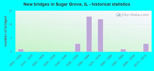
- New bridges - historical statistics
- 11900-1909
- 31950-1959
- 131960-1969
- 121970-1979
- 11990-1999
- 32010-2019
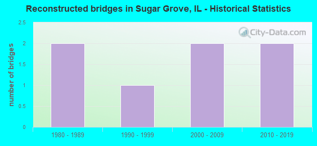
- Reconstructed bridges - Historical Statistics
- 21980-1989
- 11990-1999
- 22000-2009
- 22010-2019
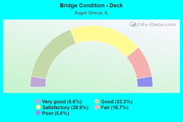
- Bridge Condition - Deck
- 5.6%Very good
- 33.3%Good
- 38.9%Satisfactory
- 16.7%Fair
- 5.6%Poor
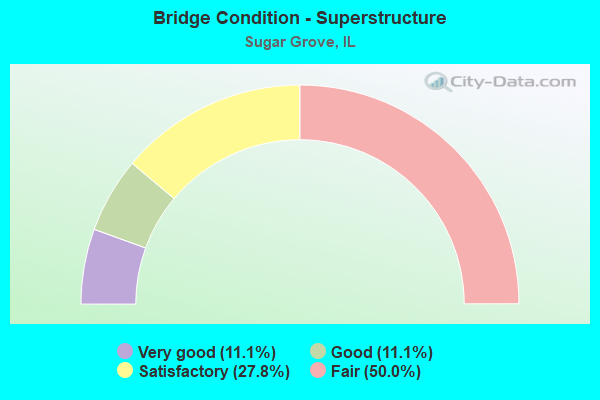
- Bridge Condition - Superstructure
- 11.1%Very good
- 11.1%Good
- 27.8%Satisfactory
- 50.0%Fair
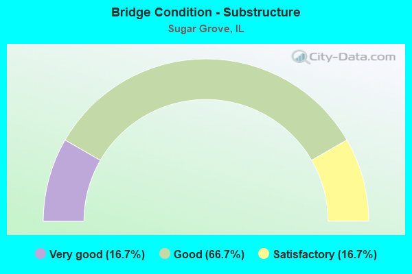
- Bridge Condition - Substructure
- 16.7%Very good
- 66.7%Good
- 16.7%Satisfactory
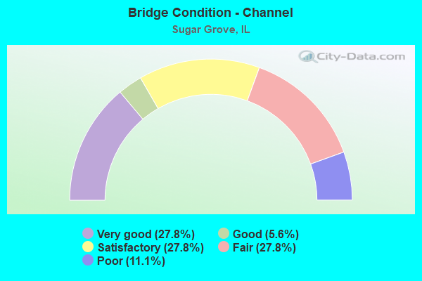
- Bridge Condition - Channel
- 27.8%Very good
- 5.6%Good
- 27.8%Satisfactory
- 27.8%Fair
- 11.1%Poor
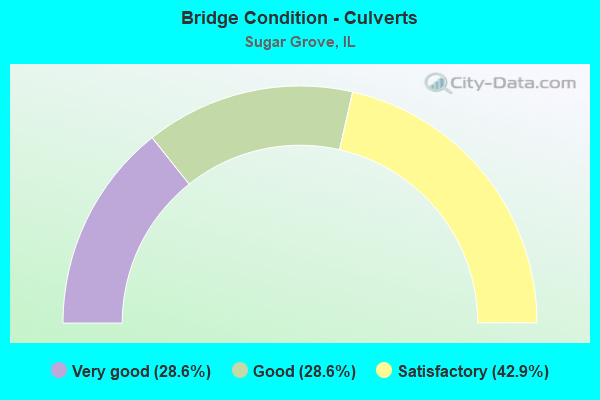
- Bridge Condition - Culverts
- 28.6%Very good
- 28.6%Good
- 42.9%Satisfactory
Find on map >> Show street view
Structure Number: 450024, Location: 1.0 M S OF I-88 (Lat: 41.804936, Lng: -88.460497), Route carried "on" structure: State highway 47, Year Built: 1968, Year Reconstructed: 2003, Status: Open, Structure Length: 3.56m (11.68ft), Average Daily Traffic: 9,700 (year 2021), Truck Traffic: 22%, Average Future Daily Traffic: 12,569 (year 2032), Design Load: HS 20, Features Intersected: BLACKBERRY CREEK
Minimum Vertical Clearance: 30+ m (98+ ft), Kilometerpoint: 192.472, Lanes on structure: 2, Base Highway Network: Yes, Owner: State Highway Agency, Approaching Roadway Width: 13.4m (44.0ft), Skew: 3 degrees, Material/Design: Steel continuous, Design/Construction: Stringer/Multi-beam, Number Of Spans In Main Unit: 2, Length of Maximum Span: 16.9m (55.4ft), Curb-To-Curb Width: 13.4m (44.0ft), Out-to-Out Width: 14.4m (47.2ft)
Condition: Deck: Good, Superstructure: Very good, Substructure: Good, Channel: Satisfactory, Operating Rating: 89.1 metric tons, Method Used To Determine Operating Rating: Load Factor (LF) rating reported by rating factor (RF) method using MS18 loading, Inventory Rating: 54.4 metric tons, Method Used To Determine Inventory Rating: Load Factor (LF) rating reported by rating factor (RF) method using MS18 loading, Structural Evaluation: Better than present minimum criteria, Deck Geometry: Equal to present minimum criteria, Waterway Adequacy: Superior to present desirable criteria, Approach Roadway Alignment: Equal to present desirable criteria, Length Of Structure Improvement: 3.57m (11.71ft), Designated Inspection Frequency: Every 48 months, Inspection Date: Febuary 2020, Bridge Improvement Cost: $418,000, Roadway Improvement Cost: $42,000, Total Project Cost: $627,000, Deck Structure Type: Concrete Cast-file-Place, Wearing Surface/Protective System: Deck Protection: Epoxy Coated Reinforcing
Find on map >> Show street view
Structure Number: 450026, Location: .4M N OF GALENA BLVD (Lat: 41.774381, Lng: -88.412156), Route carried "on" structure: State highway 56, Year Built: 1958, Year Reconstructed: 2010, Status: Open, Structure Length: 2.77m (9.09ft), Average Daily Traffic: 17,300 (year 2021), Truck Traffic: 13%, Average Future Daily Traffic: 12,313 (year 2032), Design Load: HS 20+Mod, Features Intersected: BLACKBERRY CREEK
Minimum Vertical Clearance: 30+ m (98+ ft), Kilometerpoint: 3.025, Lanes on structure: 2, Base Highway Network: Yes, Owner: State Highway Agency, Approaching Roadway Width: 9.1m (29.9ft), Material/Design: Steel, Design/Construction: Stringer/Multi-beam, Number Of Spans In Main Unit: 2, Length of Maximum Span: 13.7m (44.9ft), Curb-To-Curb Width: 9.9m (32.5ft), Out-to-Out Width: 10.9m (35.8ft)
Condition: Deck: Good, Superstructure: Fair, Substructure: Good, Channel: Fair, Operating Rating: 89.1 metric tons, Method Used To Determine Operating Rating: Load Factor (LF) rating reported by rating factor (RF) method using MS18 loading, Inventory Rating: 67.4 metric tons, Method Used To Determine Inventory Rating: Load Factor (LF) rating reported by rating factor (RF) method using MS18 loading, Structural Evaluation: Somewhat better than minimum adequacy, Deck Geometry: High priority of replacement, Waterway Adequacy: Equal to present minimum criteria, Approach Roadway Alignment: Equal to present desirable criteria, Length Of Structure Improvement: 2.80m (9.19ft), Designated Inspection Frequency: Every 24 months, Inspection Date: January 2020, Bridge Improvement Cost: $213,000, Roadway Improvement Cost: $21,000, Total Project Cost: $320,000, Deck Structure Type: Concrete Cast-file-Place, Wearing Surface/Protective System: Deck Protection: Epoxy Coated Reinforcing
Find on map >> Show street view
Structure Number: 450027, Location: .4M N OF GALENA BLVD (Lat: 41.774519, Lng: -88.412097), Route carried "on" structure: State highway 56, Year Built: 1958, Year Reconstructed: 2010, Status: Open, Structure Length: 2.77m (9.09ft), Average Daily Traffic: 17,300 (year 2021), Truck Traffic: 13%, Average Future Daily Traffic: 12,313 (year 2032), Design Load: HS 20+Mod, Features Intersected: BLACKBERRY CREEK
Minimum Vertical Clearance: 30+ m (98+ ft), Kilometerpoint: 3.042, Lanes on structure: 2, Base Highway Network: Yes, Owner: State Highway Agency, Approaching Roadway Width: 9.1m (29.9ft), Material/Design: Steel, Design/Construction: Stringer/Multi-beam, Number Of Spans In Main Unit: 2, Length of Maximum Span: 13.7m (44.9ft), Curb-To-Curb Width: 9.9m (32.5ft), Out-to-Out Width: 10.9m (35.8ft)
Condition: Deck: Good, Superstructure: Fair, Substructure: Good, Channel: Fair, Operating Rating: 89.1 metric tons, Method Used To Determine Operating Rating: Load Factor (LF) rating reported by rating factor (RF) method using MS18 loading, Inventory Rating: 67.4 metric tons, Method Used To Determine Inventory Rating: Load Factor (LF) rating reported by rating factor (RF) method using MS18 loading, Structural Evaluation: Somewhat better than minimum adequacy, Deck Geometry: High priority of replacement, Waterway Adequacy: Equal to present minimum criteria, Approach Roadway Alignment: Equal to present desirable criteria, Length Of Structure Improvement: 2.77m (9.09ft), Designated Inspection Frequency: Every 24 months, Inspection Date: January 2020, Bridge Improvement Cost: $250,000, Roadway Improvement Cost: $25,000, Total Project Cost: $375,000, Deck Structure Type: Concrete Cast-file-Place, Wearing Surface/Protective System: Deck Protection: Epoxy Coated Reinforcing
Find on map >> Show street view
Structure Number: 450035, Location: 4 M S I-88 (Lat: 41.765217, Lng: -88.442753), Route carried "on" structure: US 30, Year Built: 1961, Year Reconstructed: 1985, Status: Open, Structure Length: 6.39m (20.96ft), Average Daily Traffic: 10,650 (year 2021), Truck Traffic: 12%, Average Future Daily Traffic: 6,667 (year 2032), Design Load: HS 20, Features Intersected: IL 47, Facility Carried by Structure: IL 56 EB
Minimum Vertical Clearance: 30+ m (98+ ft), Kilometerpoint: 149.086, Lanes on structure: 2, Lanes under structure: 6, Base Highway Network: Yes, Owner: State Highway Agency, Approaching Roadway Width: 9.2m (30.2ft), Material/Design: Steel continuous, Design/Construction: Stringer/Multi-beam, Number Of Spans In Main Unit: 4, Length of Maximum Span: 19.1m (62.7ft), Curb-To-Curb Width: 9.2m (30.2ft), Out-to-Out Width: 10.2m (33.5ft)
Condition: Deck: Satisfactory, Superstructure: Fair, Substructure: Good, Operating Rating: 64.2 metric tons, Method Used To Determine Operating Rating: Load Factor (LF) rating reported by rating factor (RF) method using MS18 loading, Inventory Rating: 34.3 metric tons, Method Used To Determine Inventory Rating: Load Factor (LF) rating reported by rating factor (RF) method using MS18 loading, Structural Evaluation: Somewhat better than minimum adequacy, Deck Geometry: Meets minimum limits, Underclear: Meets minimum limits, Approach Roadway Alignment: Better than present minimum criteria, Length Of Structure Improvement: 6.40m (21.00ft), Designated Inspection Frequency: Every 24 months, Inspection Date: June 2020, Bridge Improvement Cost: $544,000, Roadway Improvement Cost: $54,000, Total Project Cost: $816,000, Deck Structure Type: Concrete Cast-file-Place, Wearing Surface/Protective System: Wearing Surface: Latex Concrete, Deck Protection: Epoxy Coated Reinforcing
Find on map >> Show street view
Structure Number: 450036, Location: 4 M S I-88 (Lat: 41.765217, Lng: -88.442608), Route carried "on" structure: State highway 56, Year Built: 1961, Year Reconstructed: 1985, Status: Open, Structure Length: 6.39m (20.96ft), Average Daily Traffic: 16,900 (year 2021), Truck Traffic: 9%, Average Future Daily Traffic: 11,229 (year 2032), Design Load: HS 20, Features Intersected: IL 47
Minimum Vertical Clearance: 30+ m (98+ ft), Kilometerpoint: 0.000, Lanes on structure: 3, Lanes under structure: 6, Base Highway Network: Yes, Owner: State Highway Agency, Approaching Roadway Width: 13.6m (44.6ft), Material/Design: Steel continuous, Design/Construction: Stringer/Multi-beam, Number Of Spans In Main Unit: 4, Length of Maximum Span: 19.1m (62.7ft), Curb-To-Curb Width: 13.6m (44.6ft), Out-to-Out Width: 14.5m (47.6ft)
Condition: Deck: Satisfactory, Superstructure: Fair, Substructure: Good, Operating Rating: 66.7 metric tons, Method Used To Determine Operating Rating: Load Factor (LF) rating reported by rating factor (RF) method using MS18 loading, Inventory Rating: 36.0 metric tons, Method Used To Determine Inventory Rating: Load Factor (LF) rating reported by rating factor (RF) method using MS18 loading, Structural Evaluation: Somewhat better than minimum adequacy, Deck Geometry: Meets minimum limits, Underclear: Meets minimum limits, Approach Roadway Alignment: Better than present minimum criteria, Length Of Structure Improvement: 6.40m (21.00ft), Designated Inspection Frequency: Every 24 months, Inspection Date: June 2020, Bridge Improvement Cost: $758,000, Roadway Improvement Cost: $76,000, Total Project Cost: $1,137,000, Deck Structure Type: Concrete Cast-file-Place, Wearing Surface/Protective System: Wearing Surface: Latex Concrete, Deck Protection: Epoxy Coated Reinforcing
Find on map >> Show street view
Structure Number: 450037, Location: 1.3 M E OF IL 47 (Lat: 41.769594, Lng: -88.416894), Route carried "on" structure: Other road , Year Built: 1961, Year Reconstructed: 2012, Status: Open, Structure Length: 7.58m (24.87ft), Average Daily Traffic: 8,950 (year 2018), Truck Traffic: 5%, Average Future Daily Traffic: 10,463 (year 2032), Design Load: HS 20, Features Intersected: IL 56, Facility Carried by Structure: GALENA BLVD WEST
Minimum Vertical Clearance: 30+ m (98+ ft), Kilometerpoint: 4.361, Lanes on structure: 4, Lanes under structure: 5, Base Highway Network: Yes, Owner: State Highway Agency, Approaching Roadway Width: 20.2m (66.3ft), Skew: 33 degrees, Material/Design: Steel continuous, Design/Construction: Stringer/Multi-beam, Number Of Spans In Main Unit: 4, Length of Maximum Span: 26.5m (86.9ft), Curb-To-Curb Width: 20.2m (66.3ft), Out-to-Out Width: 25.5m (83.7ft)
Condition: Deck: Satisfactory, Superstructure: Fair, Substructure: Good, Operating Rating: 63.8 metric tons, Method Used To Determine Operating Rating: Load Factor (LF) rating reported by rating factor (RF) method using MS18 loading, Inventory Rating: 38.2 metric tons, Method Used To Determine Inventory Rating: Load Factor (LF) rating reported by rating factor (RF) method using MS18 loading, Structural Evaluation: Somewhat better than minimum adequacy, Deck Geometry: Better than present minimum criteria, Underclear: High priority of replacement, Approach Roadway Alignment: Equal to present desirable criteria, Length Of Structure Improvement: 8.35m (27.40ft), Designated Inspection Frequency: Every 24 months, Inspection Date: July 2020, Bridge Improvement Cost: $1,805,000, Roadway Improvement Cost: $181,000, Total Project Cost: $2,708,000, Deck Structure Type: Concrete Cast-file-Place, Wearing Surface/Protective System: Deck Protection: Epoxy Coated Reinforcing
Find on map >> Show street view
Structure Number: 450081, Location: 2.5 M NE OF IL 47 (Lat: 41.781111, Lng: -88.409831), Route carried "on" structure: Other road , Year Built: 1963, Status: Open, Structure Length: 5.89m (19.32ft), Average Daily Traffic: 2,600 (year 2018), Truck Traffic: 12%, Average Future Daily Traffic: 6,635 (year 2032), Design Load: HS 20, Features Intersected: IL 56, Facility Carried by Structure: HANKES RD
Minimum Vertical Clearance: 30+ m (98+ ft), Kilometerpoint: 2.832, Lanes on structure: 2, Lanes under structure: 4, Owner: State Highway Agency, Approaching Roadway Width: 7.9m (25.9ft), Skew: 1 degrees, Material/Design: Steel continuous, Design/Construction: Stringer/Multi-beam, Number Of Spans In Main Unit: 4, Length of Maximum Span: 16.7m (54.8ft), Curb-To-Curb Width: 8.5m (27.9ft), Out-to-Out Width: 10.4m (34.1ft)
Condition: Deck: Poor, Superstructure: Fair, Substructure: Very good, Operating Rating: 58.0 metric tons, Method Used To Determine Operating Rating: Load Factor (LF) rating reported by rating factor (RF) method using MS18 loading, Inventory Rating: 35.0 metric tons, Method Used To Determine Inventory Rating: Load Factor (LF) rating reported by rating factor (RF) method using MS18 loading, Structural Evaluation: Somewhat better than minimum adequacy, Deck Geometry: Meets minimum limits, Underclear: High priority of corrective action, Approach Roadway Alignment: Somewhat better than minimum adequacy, Designated Inspection Frequency: Every 24 months, Inspection Date: December 2021, Deck Structure Type: Concrete Cast-file-Place, Wearing Surface/Protective System: Wearing Surface: Bituminous
Find on map >> Show street view
Structure Number: 450082, Location: 5 M N OF IL 56 (Lat: 41.818219, Lng: -88.466350), Route carried "on" structure: State highway 47, Year Built: 1972, Year Reconstructed: 2008, Status: Open, Structure Length: 7.28m (23.88ft), Average Daily Traffic: 9,700 (year 2021), Truck Traffic: 22%, Average Future Daily Traffic: 12,569 (year 2032), Features Intersected: I- 88 EW TOLL
Minimum Vertical Clearance: 30+ m (98+ ft), Kilometerpoint: 194.098, Lanes on structure: 4, Lanes under structure: 4, Base Highway Network: Yes, Owner: State Highway Agency, Approaching Roadway Width: 9.8m (32.2ft), Skew: 31 degrees, Material/Design: Prestressed concrete continuous, Design/Construction: Stringer/Multi-beam, Number Of Spans In Main Unit: 4, Length of Maximum Span: 25.1m (82.3ft), Curb-To-Curb Width: 23.5m (77.1ft), Out-to-Out Width: 28.0m (91.9ft)
Condition: Deck: Good, Superstructure: Satisfactory, Substructure: Good, Operating Rating: 56.7 metric tons, Method Used To Determine Operating Rating: Load Factor (LF) rating reported by rating factor (RF) method using MS18 loading, Inventory Rating: 34.0 metric tons, Method Used To Determine Inventory Rating: Load Factor (LF) rating reported by rating factor (RF) method using MS18 loading, Structural Evaluation: Equal to present minimum criteria, Deck Geometry: Superior to present desirable criteria, Underclear: Equal to present minimum criteria, Approach Roadway Alignment: Better than present minimum criteria, Length Of Structure Improvement: 7.28m (23.88ft), Designated Inspection Frequency: Every 24 months, Inspection Date: August 2020, Bridge Improvement Cost: $1,688,000, Roadway Improvement Cost: $169,000, Total Project Cost: $2,532,000, Deck Structure Type: Concrete Cast-file-Place, Wearing Surface/Protective System: Deck Protection: Epoxy Coated Reinforcing
Find on map >> Show street view
Structure Number: 452001, Location: 0.4 M S OF I-88 (Lat: 41.814053, Lng: -88.463972), Route carried "on" structure: State highway 47, Year Built: 1971, Status: Open, Structure Length: 0.72m (2.36ft), Average Daily Traffic: 9,700 (year 2021), Truck Traffic: 22%, Average Future Daily Traffic: 12,569 (year 2032), Design Load: HS 20, Features Intersected: BLACKBERRY CREEK TRB
Minimum Vertical Clearance: 30+ m (98+ ft), Kilometerpoint: 193.567, Lanes on structure: 2, Base Highway Network: Yes, Owner: State Highway Agency, Approaching Roadway Width: 9.8m (32.2ft), Material/Design: Concrete continuous, Design/Construction: Culvert, Number Of Spans In Main Unit: 3, Length of Maximum Span: 2.3m (7.5ft)
Condition: Channel: Good, Culverts: Good, Operating Rating: 95.6 metric tons, Method Used To Determine Operating Rating: Load Factor (LF) rating reported by rating factor (RF) method using MS18 loading, Inventory Rating: 57.0 metric tons, Method Used To Determine Inventory Rating: Load Factor (LF) rating reported by rating factor (RF) method using MS18 loading, Structural Evaluation: Better than present minimum criteria, Waterway Adequacy: Better than present minimum criteria, Approach Roadway Alignment: Equal to present desirable criteria, Designated Inspection Frequency: Every 24 months, Inspection Date: Febuary 2020
Find on map >> Show street view
Structure Number: 452002, Location: 4 MI NE OF IL 47 (Lat: 41.794536, Lng: -88.397008), Route carried "on" structure: State highway 56, Year Built: 1958, Status: Open, Structure Length: 1.05m (3.44ft), Average Daily Traffic: 17,300 (year 2021), Truck Traffic: 13%, Average Future Daily Traffic: 12,313 (year 2032), Features Intersected: LAKE RUN
Minimum Vertical Clearance: 30+ m (98+ ft), Kilometerpoint: 5.858, Lanes on structure: 2, Base Highway Network: Yes, Toll: On toll road, Owner: State Toll Authority, Approaching Roadway Width: 11.0m (36.1ft), Skew: 3 degrees, Material/Design: Concrete, Design/Construction: Culvert, Number Of Spans In Main Unit: 2, Length of Maximum Span: 4.0m (13.1ft)
Condition: Channel: Very good, Culverts: Satisfactory, Operating Rating: 57.0 metric tons, Method Used To Determine Operating Rating: Load Factor (LF) rating reported by rating factor (RF) method using MS18 loading, Inventory Rating: 34.3 metric tons, Method Used To Determine Inventory Rating: Load Factor (LF) rating reported by rating factor (RF) method using MS18 loading, Structural Evaluation: Equal to present minimum criteria, Waterway Adequacy: Equal to present desirable criteria, Approach Roadway Alignment: Equal to present desirable criteria, Designated Inspection Frequency: Every 24 months, Inspection Date: August 2019, Deck Structure Type: Concrete Cast-file-Place
Find on map >> Show street view
Structure Number: 452019, Location: 2.5 MI E. OF US 12 (Lat: 41.796653, Lng: -88.397844), Route carried "on" structure: Interstate 88, Year Built: 1972, Status: Open, Structure Length: 0.97m (3.18ft), Average Daily Traffic: 38,200 (year 2020), Truck Traffic: 22%, Average Future Daily Traffic: 31,900 (year 2032), Design Load: HS 20, Features Intersected: LAKE RUN
Minimum Vertical Clearance: 30+ m (98+ ft), Kilometerpoint: 182.028, Lanes on structure: 4, Base Highway Network: Yes, Toll: On toll road, Owner: State Toll Authority, Approaching Roadway Width: 39.6m (129.9ft), Skew: 3 degrees, Material/Design: Concrete continuous, Design/Construction: Culvert, Number Of Spans In Main Unit: 2, Length of Maximum Span: 3.7m (12.1ft)
Condition: Channel: Satisfactory, Culverts: Satisfactory, Operating Rating: 41.1 metric tons, Method Used To Determine Operating Rating: Load Factor (LF) rating reported by rating factor (RF) method using MS18 loading, Inventory Rating: 25.3 metric tons, Method Used To Determine Inventory Rating: Load Factor (LF) rating reported by rating factor (RF) method using MS18 loading, Structural Evaluation: Equal to present minimum criteria, Waterway Adequacy: Equal to present desirable criteria, Approach Roadway Alignment: Equal to present desirable criteria, Designated Inspection Frequency: Every 24 months, Inspection Date: August 2019, Deck Structure Type: Concrete Cast-file-Place
Find on map >> Show street view
Structure Number: 45202, Location: .7 MI E. OF ILL 47 (Lat: 41.814992, Lng: -88.453550), Route carried "on" structure: Interstate 88, Year Built: 1972, Status: Open, Structure Length: 0.81m (2.66ft), Average Daily Traffic: 38,200 (year 2020), Truck Traffic: 22%, Average Future Daily Traffic: 31,900 (year 2032), Design Load: HS 20, Features Intersected: STREAM
Minimum Vertical Clearance: 30+ m (98+ ft), Kilometerpoint: 176.766, Lanes on structure: 4, Base Highway Network: Yes, Toll: On toll road, Owner: State Toll Authority, Approaching Roadway Width: 39.6m (129.9ft), Skew: 2 degrees, Material/Design: Concrete continuous, Design/Construction: Culvert, Number Of Spans In Main Unit: 2, Length of Maximum Span: 3.4m (11.2ft)
Condition: Channel: Poor, Culverts: Good, Operating Rating: 97.2 metric tons, Method Used To Determine Operating Rating: Load Factor (LF) rating reported by rating factor (RF) method using MS18 loading, Inventory Rating: 62.9 metric tons, Method Used To Determine Inventory Rating: Load Factor (LF) rating reported by rating factor (RF) method using MS18 loading, Structural Evaluation: Better than present minimum criteria, Waterway Adequacy: Equal to present desirable criteria, Approach Roadway Alignment: Equal to present desirable criteria, Designated Inspection Frequency: Every 24 months, Inspection Date: July 2019, Deck Structure Type: Concrete Cast-file-Place
Find on map >> Show street view
Structure Number: 452121, Location: 0.5 M E of Dugan Rd (Lat: 41.764069, Lng: -88.479278), Route carried "on" structure: US 30, Year Built: 2015, Status: Open, Structure Length: 1.55m (5.09ft), Average Daily Traffic: 10,650 (year 2021), Truck Traffic: 12%, Average Future Daily Traffic: 22,000 (year 2041), Design Load: HS 25 or greater, Features Intersected: SUGAR GROVE BR
Minimum Vertical Clearance: 30+ m (98+ ft), Kilometerpoint: 146.076, Lanes on structure: 2, Base Highway Network: Yes, Owner: State Highway Agency, Approaching Roadway Width: 13.4m (44.0ft), Skew: 1 degrees, Material/Design: Concrete, Design/Construction: Culvert, Number Of Spans In Main Unit: 3, Length of Maximum Span: 3.7m (12.1ft), Curb-To-Curb Width: 13.4m (44.0ft)
Condition: Channel: Very good, Culverts: Very good, Operating Rating: 45.4 metric tons, Method Used To Determine Operating Rating: Load and Resistance Factor Rating (LRFR) rating reported by rating factor(RF) method using HL-93 loadings, Inventory Rating: 35.0 metric tons, Method Used To Determine Inventory Rating: Load and Resistance Factor Rating (LRFR) rating reported by rating factor(RF) method using HL-93 loadings, Structural Evaluation: Equal to present desirable criteria, Deck Geometry: Equal to present minimum criteria, Waterway Adequacy: Equal to present desirable criteria, Approach Roadway Alignment: Equal to present desirable criteria, Designated Inspection Frequency: Every 48 months, Inspection Date: December 2021, Wearing Surface/Protective System: Deck Protection: Epoxy Coated Reinforcing
Find on map >> Show street view
Structure Number: 452122, Location: 1.1M E of Dugan Rd (Lat: 41.764828, Lng: -88.468719), Route carried "on" structure: US 30, Year Built: 2015, Status: Open, Structure Length: 0.87m (2.85ft), Average Daily Traffic: 10,650 (year 2021), Truck Traffic: 12%, Average Future Daily Traffic: 22,000 (year 2041), Design Load: HS 25 or greater, Features Intersected: SUGAR GROVE NORTH BR
Minimum Vertical Clearance: 30+ m (98+ ft), Kilometerpoint: 146.929, Lanes on structure: 2, Base Highway Network: Yes, Owner: State Highway Agency, Approaching Roadway Width: 14.9m (48.9ft), Skew: 10 degrees, Material/Design: Concrete, Design/Construction: Culvert, Number Of Spans In Main Unit: 3, Length of Maximum Span: 2.4m (7.9ft), Curb-To-Curb Width: 14.9m (48.9ft)
Condition: Channel: Very good, Culverts: Very good, Operating Rating: 43.7 metric tons, Method Used To Determine Operating Rating: Load and Resistance Factor Rating (LRFR) rating reported by rating factor(RF) method using HL-93 loadings, Inventory Rating: 33.7 metric tons, Method Used To Determine Inventory Rating: Load and Resistance Factor Rating (LRFR) rating reported by rating factor(RF) method using HL-93 loadings, Structural Evaluation: Equal to present desirable criteria, Deck Geometry: Superior to present desirable criteria, Waterway Adequacy: Equal to present desirable criteria, Approach Roadway Alignment: Equal to present desirable criteria, Designated Inspection Frequency: Every 48 months, Inspection Date: December 2021, Wearing Surface/Protective System: Deck Protection: Epoxy Coated Reinforcing
Find on map >> Show street view
Structure Number: 45303, Location: 1.0 MI N SUGAR GROVE (Lat: 41.780094, Lng: -88.439811), Route carried "on" structure: Other road , Year Built: 2017, Status: Open, Structure Length: 2.60m (8.53ft), Average Daily Traffic: 6,500 (year 2018), Truck Traffic: 8%, Average Future Daily Traffic: 9,953 (year 2032), Design Load: HS 25 or greater, Features Intersected: BLACKBERRY CREEK, Facility Carried by Structure: BLISS ROAD
Minimum Vertical Clearance: 30+ m (98+ ft), Kilometerpoint: 7.837, Lanes on structure: 2, Base Highway Network: Yes, Owner: County Highway Agency, Approaching Roadway Width: 14.0m (45.9ft), Material/Design: Steel, Design/Construction: Stringer/Multi-beam, Number Of Spans In Main Unit: 1, Length of Maximum Span: 25.0m (82.0ft), Curb-To-Curb Width: 14.8m (48.6ft), Out-to-Out Width: 15.8m (51.8ft)
Condition: Deck: Very good, Superstructure: Very good, Substructure: Very good, Channel: Very good, Operating Rating: 66.7 metric tons, Method Used To Determine Operating Rating: Load and Resistance Factor Rating (LRFR) rating reported by rating factor(RF) method using HL-93 loadings, Inventory Rating: 51.2 metric tons, Method Used To Determine Inventory Rating: Load and Resistance Factor Rating (LRFR) rating reported by rating factor(RF) method using HL-93 loadings, Structural Evaluation: Equal to present desirable criteria, Deck Geometry: Superior to present desirable criteria, Waterway Adequacy: Superior to present desirable criteria, Approach Roadway Alignment: Equal to present desirable criteria, Designated Inspection Frequency: Every 48 months, Inspection Date: October 2019, Deck Structure Type: Concrete Cast-file-Place, Wearing Surface/Protective System: Deck Protection: Bituminous
Find on map >> Show street view
Structure Number: 453057, Location: 0.4 MI W ILL 47 (Lat: 41.823400, Lng: -88.475036), Route carried "on" structure: County highway , Year Built: 1961, Status: Open, Structure Length: 1.43m (4.69ft), Average Daily Traffic: 150 (year 2018), Truck Traffic: 9%, Average Future Daily Traffic: 319 (year 2032), Design Load: HS 15, Features Intersected: BLACKBERRY CREEK, Facility Carried by Structure: SEAVEY ROAD
Minimum Vertical Clearance: 30+ m (98+ ft), Kilometerpoint: 0.016, Lanes on structure: 2, Owner: Town or Township Highway Agency, Approaching Roadway Width: 3.7m (12.1ft), Skew: 3 degrees, Material/Design: Concrete continuous, Design/Construction: Slab, Number Of Spans In Main Unit: 2, Length of Maximum Span: 7.2m (23.6ft), Curb-To-Curb Width: 7.3m (24.0ft), Out-to-Out Width: 8.0m (26.2ft)
Condition: Deck: Good, Superstructure: Good, Substructure: Satisfactory, Channel: Poor, Operating Rating: 47.6 metric tons, Method Used To Determine Operating Rating: Load Factor (LF) rating reported by rating factor (RF) method using MS18 loading, Inventory Rating: 28.5 metric tons, Method Used To Determine Inventory Rating: Load Factor (LF) rating reported by rating factor (RF) method using MS18 loading, Structural Evaluation: Equal to present minimum criteria, Deck Geometry: Somewhat better than minimum adequacy, Waterway Adequacy: Equal to present desirable criteria, Approach Roadway Alignment: High priority of corrective action, Designated Inspection Frequency: Every 24 months, Inspection Date: May 2021, Deck Structure Type: Concrete Cast-file-Place
Find on map >> Show street view
Structure Number: 453061, Location: 2.0 MI N SUGAR GROVE (Lat: 41.809347, Lng: -88.466411), Route carried "on" structure: Other road , Year Built: 1967, Status: Open, Structure Length: 3.31m (10.86ft), Average Daily Traffic: 850 (year 2018), Truck Traffic: 6%, Average Future Daily Traffic: 957 (year 2032), Design Load: HS 15, Features Intersected: BLACKBERRY CREEK, Facility Carried by Structure: SCOTT ROAD
Minimum Vertical Clearance: 30+ m (98+ ft), Kilometerpoint: 2.511, Lanes on structure: 2, Owner: Town or Township Highway Agency, Approaching Roadway Width: 9.1m (29.9ft), Skew: 3 degrees, Material/Design: Concrete continuous, Design/Construction: Slab, Number Of Spans In Main Unit: 3, Length of Maximum Span: 12.6m (41.3ft), Curb-To-Curb Width: 7.3m (24.0ft), Out-to-Out Width: 7.9m (25.9ft)
Condition: Deck: Satisfactory, Superstructure: Satisfactory, Substructure: Good, Channel: Fair, Operating Rating: 45.0 metric tons, Method Used To Determine Operating Rating: Load Factor (LF) rating reported by rating factor (RF) method using MS18 loading, Inventory Rating: 27.2 metric tons, Method Used To Determine Inventory Rating: Load Factor (LF) rating reported by rating factor (RF) method using MS18 loading, Structural Evaluation: Equal to present minimum criteria, Deck Geometry: Meets minimum limits, Waterway Adequacy: Equal to present desirable criteria, Approach Roadway Alignment: Equal to present desirable criteria, Designated Inspection Frequency: Every 24 months, Inspection Date: May 2021, Deck Structure Type: Concrete Cast-file-Place
Find on map >> Show street view
Structure Number: 453071, Location: 2 MI N SUGAR GROVE (Lat: 41.785461, Lng: -88.447956), Route carried "on" structure: County highway , Year Built: 1968, Status: Posted for load, Structure Length: 2.80m (9.19ft), Average Daily Traffic: 675 (year 2018), Truck Traffic: 4%, Average Future Daily Traffic: 702 (year 2032), Design Load: HS 15, Features Intersected: Blackberry Creek, Facility Carried by Structure: TR-179 (KeDeKa Rd)
Minimum Vertical Clearance: 30+ m (98+ ft), Kilometerpoint: 0.129, Lanes on structure: 2, Owner: Town or Township Highway Agency, Approaching Roadway Width: 6.7m (22.0ft), Material/Design: Concrete continuous, Design/Construction: Slab, Number Of Spans In Main Unit: 3, Length of Maximum Span: 10.7m (35.1ft), Curb-To-Curb Width: 7.3m (24.0ft), Out-to-Out Width: 7.9m (25.9ft)
Condition: Deck: Satisfactory, Superstructure: Satisfactory, Substructure: Satisfactory, Channel: Fair, Operating Rating: 40.8 metric tons, Method Used To Determine Operating Rating: Load Factor (LF) rating reported by rating factor (RF) method using MS18 loading, Inventory Rating: 24.6 metric tons, Method Used To Determine Inventory Rating: Load Factor (LF) rating reported by rating factor (RF) method using MS18 loading, Structural Evaluation: Equal to present minimum criteria, Deck Geometry: Meets minimum limits, Waterway Adequacy: Equal to present desirable criteria, Approach Roadway Alignment: Equal to present desirable criteria, Bridge Posting: Required (Relationship of Operating Rating to Maximum Legal Load: 20.0 - 29.9% below), Designated Inspection Frequency: Every 24 months, Inspection Date: April 2021, Deck Structure Type: Concrete Cast-file-Place, Wearing Surface/Protective System: Wearing Surface: Bituminous
Find on map >> Show street view
Structure Number: 453073, Location: 2.0 MI E SUGAR GROVE (Lat: 41.780336, Lng: -88.407044), Route carried "on" structure: Other road , Year Built: 1967, Status: Open, Structure Length: 0.91m (2.99ft), Average Daily Traffic: 2,600 (year 2018), Truck Traffic: 12%, Average Future Daily Traffic: 6,635 (year 2032), Design Load: HS 15, Features Intersected: LAKE RUN CREEK, Facility Carried by Structure: HANKES ROAD
Minimum Vertical Clearance: 30+ m (98+ ft), Kilometerpoint: 3.122, Lanes on structure: 2, Owner: Town or Township Highway Agency, Approaching Roadway Width: 7.3m (24.0ft), Skew: 2 degrees, Material/Design: Concrete, Design/Construction: Slab, Number Of Spans In Main Unit: 1, Length of Maximum Span: 8.5m (27.9ft), Curb-To-Curb Width: 8.5m (27.9ft), Out-to-Out Width: 9.1m (29.9ft)
Condition: Deck: Fair, Superstructure: Fair, Substructure: Good, Channel: Satisfactory, Operating Rating: 42.1 metric tons, Method Used To Determine Operating Rating: Load Factor (LF) rating reported by rating factor (RF) method using MS18 loading, Inventory Rating: 25.3 metric tons, Method Used To Determine Inventory Rating: Load Factor (LF) rating reported by rating factor (RF) method using MS18 loading, Structural Evaluation: Somewhat better than minimum adequacy, Deck Geometry: Meets minimum limits, Waterway Adequacy: Equal to present desirable criteria, Approach Roadway Alignment: Equal to present desirable criteria, Designated Inspection Frequency: Every 24 months, Inspection Date: April 2021, Deck Structure Type: Concrete Cast-file-Place, Wearing Surface/Protective System: Wearing Surface: Bituminous
Find on map >> Show street view
Structure Number: 453092, Location: 2.0 MI N SUGAR GROVE (Lat: 41.812817, Lng: -88.473728), Route carried "on" structure: County highway , Year Built: 1971, Status: Open, Structure Length: 1.74m (5.71ft), Average Daily Traffic: 50 (year 2010), Average Future Daily Traffic: 64 (year 2032), Design Load: HS 15, Features Intersected: BLACKBERRY CREEK, Facility Carried by Structure: FINLEY ROAD
Minimum Vertical Clearance: 30+ m (98+ ft), Kilometerpoint: 0.933, Lanes on structure: 2, Owner: Town or Township Highway Agency, Approaching Roadway Width: 6.1m (20.0ft), Material/Design: Concrete continuous, Design/Construction: Slab, Number Of Spans In Main Unit: 2, Length of Maximum Span: 8.5m (27.9ft), Curb-To-Curb Width: 7.3m (24.0ft), Out-to-Out Width: 7.9m (25.9ft)
Condition: Deck: Satisfactory, Superstructure: Satisfactory, Substructure: Good, Channel: Fair, Operating Rating: 45.4 metric tons, Method Used To Determine Operating Rating: Load Factor (LF) rating reported by rating factor (RF) method using MS18 loading, Inventory Rating: 25.6 metric tons, Method Used To Determine Inventory Rating: Load Factor (LF) rating reported by rating factor (RF) method using MS18 loading, Structural Evaluation: Equal to present minimum criteria, Deck Geometry: Equal to present minimum criteria, Waterway Adequacy: Equal to present desirable criteria, Approach Roadway Alignment: Equal to present desirable criteria, Designated Inspection Frequency: Every 24 months, Inspection Date: May 2021, Deck Structure Type: Concrete Cast-file-Place
Find on map >> Show street view
Structure Number: 453148, Location: 0.35 MI W./ DUGAN RD (Lat: 41.762553, Lng: -88.496267), Route carried "on" structure: Other road , Year Built: 1999, Status: Open, Structure Length: 1.40m (4.59ft), Average Daily Traffic: 5,700 (year 2018), Truck Traffic: 4%, Average Future Daily Traffic: 7,528 (year 2032), Design Load: HS 20, Features Intersected: DUFFIN DRAIN, Facility Carried by Structure: GRANART ROAD
Minimum Vertical Clearance: 30+ m (98+ ft), Kilometerpoint: 2.832, Lanes on structure: 2, Base Highway Network: Yes, Owner: City or Municipal Highway Agency, Approaching Roadway Width: 12.2m (40.0ft), Material/Design: Prestressed concrete, Design/Construction: Box Beam or Girders - Multiple, Number Of Spans In Main Unit: 1, Length of Maximum Span: 12.7m (41.7ft), Curb-To-Curb Width: 12.2m (40.0ft), Out-to-Out Width: 12.2m (40.0ft)
Condition: Deck: Satisfactory, Superstructure: Fair, Substructure: Very good, Channel: Satisfactory, Operating Rating: 53.8 metric tons, Method Used To Determine Operating Rating: Assigned rating based on Load Factor Design (LFD) reported by rating factor (RF) using MS18 loading, Inventory Rating: 32.4 metric tons, Method Used To Determine Inventory Rating: Assigned rating based on Load Factor Design (LFD) reported by rating factor (RF) using MS18 loading, Structural Evaluation: Somewhat better than minimum adequacy, Deck Geometry: Somewhat better than minimum adequacy, Waterway Adequacy: Superior to present desirable criteria, Approach Roadway Alignment: Equal to present desirable criteria, Designated Inspection Frequency: Every 24 months, Inspection Date: October 2021, Deck Structure Type: Concrete Precast Panels, Wearing Surface/Protective System: Wearing Surface: Integral Concrete, Deck Protection: Epoxy Coated Reinforcing
Find on map >> Show street view
Structure Number: 455005, Location: DUGAN .6 M S OF US30 (Lat: 41.754969, Lng: -88.489075), Route carried "on" structure: Other road , Year Built: 1974, Status: Open, Structure Length: 0.73m (2.40ft), Average Daily Traffic: 2,400 (year 2018), Truck Traffic: 5%, Average Future Daily Traffic: 2,871 (year 2032), Design Load: HS 20, Features Intersected: WELCH CREEK, Facility Carried by Structure: DUGAN ROAD
Minimum Vertical Clearance: 30+ m (98+ ft), Kilometerpoint: 4.393, Lanes on structure: 2, Owner: Town or Township Highway Agency, Approaching Roadway Width: 8.5m (27.9ft), Skew: 1 degrees, Material/Design: Concrete, Design/Construction: Culvert, Number Of Spans In Main Unit: 2, Length of Maximum Span: 3.7m (12.1ft), Curb-To-Curb Width: 10.4m (34.1ft), Out-to-Out Width: 11.0m (36.1ft)
Condition: Channel: Very good, Culverts: Satisfactory, Operating Rating: 53.5 metric tons, Method Used To Determine Operating Rating: Load Factor (LF) rating reported by rating factor (RF) method using MS18 loading, Inventory Rating: 32.1 metric tons, Method Used To Determine Inventory Rating: Load Factor (LF) rating reported by rating factor (RF) method using MS18 loading, Structural Evaluation: Equal to present minimum criteria, Deck Geometry: Somewhat better than minimum adequacy, Waterway Adequacy: Equal to present desirable criteria, Approach Roadway Alignment: Equal to present desirable criteria, Designated Inspection Frequency: Every 24 months, Inspection Date: April 2021, Wearing Surface/Protective System: Wearing Surface: Bituminous
Find on map >> Show street view
Structure Number: 456805, Location: .4M E OF DUGAN RD (Lat: 41.758292, Lng: -88.483183), Route carried "on" structure: City street , Year Built: 1975, Status: Open, Structure Length: 1.16m (3.81ft), Average Daily Traffic: 475 (year 2018), Truck Traffic: 5%, Average Future Daily Traffic: 267 (year 2032), Design Load: HS 20+Mod, Features Intersected: WELCH CREEK TRIB, Facility Carried by Structure: FAY'S LANE
Minimum Vertical Clearance: 30+ m (98+ ft), Kilometerpoint: 0.563, Lanes on structure: 2, Owner: City or Municipal Highway Agency, Approaching Roadway Width: 11.3m (37.1ft), Skew: 2 degrees, Material/Design: Prestressed concrete, Design/Construction: Box Beam or Girders - Multiple, Number Of Spans In Main Unit: 1, Length of Maximum Span: 11.3m (37.1ft), Curb-To-Curb Width: 11.0m (36.1ft), Out-to-Out Width: 11.5m (37.7ft)
Condition: Deck: Fair, Superstructure: Fair, Substructure: Satisfactory, Channel: Satisfactory, Operating Rating: 49.9 metric tons, Method Used To Determine Operating Rating: Load Factor (LF) rating reported by rating factor (RF) method using MS18 loading, Inventory Rating: 29.8 metric tons, Method Used To Determine Inventory Rating: Load Factor (LF) rating reported by rating factor (RF) method using MS18 loading, Structural Evaluation: Somewhat better than minimum adequacy, Deck Geometry: Better than present minimum criteria, Waterway Adequacy: Superior to present desirable criteria, Approach Roadway Alignment: Equal to present minimum criteria, Designated Inspection Frequency: Every 24 months, Inspection Date: October 2021, Deck Structure Type: Concrete Precast Panels, Wearing Surface/Protective System: Wearing Surface: Bituminous, Membrane: Built-up
Find on map >> Show street view
Structure Number: 4599, Location: 3.5 MI W OF IL 31 (Lat: 41.794550, Lng: -88.396822), Route carried "on" structure: State highway 56, Year Built: 1972, Status: Open, Structure Length: 6.83m (22.41ft), Average Daily Traffic: 17,300 (year 2021), Truck Traffic: 13%, Average Future Daily Traffic: 12,313 (year 2032), Features Intersected: I-88 E-W TOLL RD.
Minimum Vertical Clearance: 30+ m (98+ ft), Kilometerpoint: 5.874, Lanes on structure: 2, Lanes under structure: 4, Base Highway Network: Yes, Toll: On toll road, Owner: State Toll Authority, Approaching Roadway Width: 11.9m (39.0ft), Material/Design: Steel, Design/Construction: Stringer/Multi-beam, Number Of Spans In Main Unit: 2, Length of Maximum Span: 33.5m (109.9ft), Curb-To-Curb Width: 11.6m (38.1ft), Out-to-Out Width: 13.0m (42.7ft)
Condition: Deck: Fair, Superstructure: Satisfactory, Substructure: Good, Operating Rating: 71.3 metric tons, Method Used To Determine Operating Rating: Load Factor (LF) rating reported by rating factor (RF) method using MS18 loading, Inventory Rating: 42.8 metric tons, Method Used To Determine Inventory Rating: Load Factor (LF) rating reported by rating factor (RF) method using MS18 loading, Structural Evaluation: Equal to present minimum criteria, Deck Geometry: Equal to present minimum criteria, Underclear: Equal to present minimum criteria, Approach Roadway Alignment: Equal to present desirable criteria, Designated Inspection Frequency: Every 24 months, Inspection Date: September 2020, Deck Structure Type: Concrete Cast-file-Place
Find on map >> Show street view
Structure Number: 459959, Location: 0.25 MI N DENNY RD (Lat: 41.802894, Lng: -88.428008), Route carried "on" structure: Other road , Year Built: 1972, Status: Open, Structure Length: 6.71m (22.01ft), Average Daily Traffic: 7,450 (year 2018), Truck Traffic: 3%, Average Future Daily Traffic: 6,508 (year 2032), Design Load: HS 20, Features Intersected: I-88 E-W TOLL RD., Facility Carried by Structure: BLISS RD.
Minimum Vertical Clearance: 30+ m (98+ ft), Kilometerpoint: 5.069, Lanes on structure: 2, Lanes under structure: 4, Base Highway Network: Yes, Owner: County Highway Agency, Approaching Roadway Width: 13.1m (43.0ft), Material/Design: Prestressed concrete, Design/Construction: Stringer/Multi-beam, Number Of Spans In Main Unit: 2, Length of Maximum Span: 23.8m (78.1ft), Curb-To-Curb Width: 13.2m (43.3ft), Out-to-Out Width: 13.9m (45.6ft)
Condition: Deck: Good, Superstructure: Good, Substructure: Good, Operating Rating: 70.0 metric tons, Method Used To Determine Operating Rating: Load Factor (LF) rating reported by rating factor (RF) method using MS18 loading, Inventory Rating: 42.1 metric tons, Method Used To Determine Inventory Rating: Load Factor (LF) rating reported by rating factor (RF) method using MS18 loading, Structural Evaluation: Better than present minimum criteria, Deck Geometry: Somewhat better than minimum adequacy, Underclear: Equal to present minimum criteria, Approach Roadway Alignment: Better than present minimum criteria, Designated Inspection Frequency: Every 24 months, Inspection Date: July 2019, Deck Structure Type: Concrete Precast Panels, Wearing Surface/Protective System: Wearing Surface: Other
Find on map >> Show street view
Structure Number: 450035, Location: 4 M S I-88 (Lat: 41.765217, Lng: -88.442608), Route carried "under" structure: US 30, Year Built: 1961, Structure Length: 0. m, Average Daily Traffic: 17,700 (year 2021), Truck Traffic: 17%, Features Intersected: IL 47, Facility Carried by Structure: IL 56 EB
Minimum Vertical Clearance: 4.32m (14.17ft), Kilometerpoint: 149.102, Lanes on structure: 2, Lanes under structure: 6, Material/Design: Steel continuous, Design/Construction: Stringer/Multi-beam, Length of Maximum Span: 19.1m (62.7ft)
Find on map >> Show street view
Structure Number: 450036, Location: 4 M S I-88 (Lat: 41.765431, Lng: -88.442619), Route carried "under" structure: State highway 47, Year Built: 1961, Structure Length: 0. m, Average Daily Traffic: 15,800 (year 2021), Truck Traffic: 13%, Features Intersected: IL 47, Facility Carried by Structure: IL 56 WB
Minimum Vertical Clearance: 4.29m (14.07ft), Kilometerpoint: 187.435, Lanes on structure: 3, Lanes under structure: 6, Material/Design: Steel continuous, Design/Construction: Stringer/Multi-beam, Length of Maximum Span: 19.1m (62.7ft)
Find on map >> Show street view
Structure Number: 450037, Location: 1.3 M E OF IL 47 (Lat: 41.769461, Lng: -88.415931), Route carried "under" structure: State highway 56, Year Built: 1961, Structure Length: 0. m, Average Daily Traffic: 17,300 (year 2021), Truck Traffic: 13%, Features Intersected: IL 56, Facility Carried by Structure: GALENA BLVD WEST
Minimum Vertical Clearance: 5.00m (16.40ft), Kilometerpoint: 2.366, Lanes on structure: 4, Lanes under structure: 5, Material/Design: Steel continuous, Design/Construction: Stringer/Multi-beam, Length of Maximum Span: 26.5m (86.9ft)
Find on map >> Show street view
Structure Number: 450063, Location: 0.5 M S OF ILL 56 (Lat: 41.758139, Lng: -88.442236), Route carried "under" structure: US 30, Year Built: 1900, Structure Length: 0. m, Average Daily Traffic: 17,700 (year 2021), Truck Traffic: 17%, Features Intersected: ILL 47, US 30, Facility Carried by Structure: CB+Q RR (BN RR)
Minimum Vertical Clearance: 4.47m (14.67ft), Kilometerpoint: 149.906, Lanes under structure: 4, Material/Design: Steel, Design/Construction: Stringer/Multi-beam, Length of Maximum Span: 14.9m (48.9ft)
Find on map >> Show street view
Structure Number: 450081, Location: 2.5 M NE OF IL 47 (Lat: 41.781111, Lng: -88.409831), Route carried "under" structure: State highway 56, Year Built: 1963, Structure Length: 0. m, Average Daily Traffic: 17,300 (year 2021), Truck Traffic: 13%, Features Intersected: IL 56, Facility Carried by Structure: HANKES RD
Minimum Vertical Clearance: 4.42m (14.50ft), Kilometerpoint: 3.782, Lanes on structure: 2, Lanes under structure: 4, Material/Design: Steel continuous, Design/Construction: Stringer/Multi-beam, Length of Maximum Span: 16.7m (54.8ft)
Find on map >> Show street view
Structure Number: 450082, Location: 5 M N OF IL 56 (Lat: 41.818219, Lng: -88.466350), Route carried "under" structure: Interstate 88, Year Built: 1972, Structure Length: 0. m, Average Daily Traffic: 38,200 (year 2020), Truck Traffic: 22%, Features Intersected: I- 88 EW TOLL, Facility Carried by Structure: IL 47
Minimum Vertical Clearance: 5.51m (18.08ft), Kilometerpoint: 175.623, Lanes on structure: 4, Lanes under structure: 4, Material/Design: Prestressed concrete continuous, Design/Construction: Stringer/Multi-beam, Length of Maximum Span: 25.1m (82.3ft)
Find on map >> Show street view
Structure Number: 4599, Location: 3.5 MI W OF IL 31 (Lat: 41.796581, Lng: -88.397689), Route carried "under" structure: Interstate 88, Year Built: 1972, Structure Length: 0. m, Average Daily Traffic: 38,200 (year 2020), Truck Traffic: 22%, Features Intersected: I-88 E-W TOLL RD., Facility Carried by Structure: IL 56 WB
Minimum Vertical Clearance: 5.92m (19.42ft), Kilometerpoint: 182.044, Lanes on structure: 2, Lanes under structure: 4, Toll: On toll road, Material/Design: Steel, Design/Construction: Stringer/Multi-beam, Length of Maximum Span: 33.5m (109.9ft)
Find on map >> Show street view
Structure Number: 459959, Location: 0.25 MI N DENNY RD (Lat: 41.802689, Lng: -88.428111), Route carried "under" structure: Interstate 88, Year Built: 1972, Structure Length: 0. m, Average Daily Traffic: 38,200 (year 2020), Truck Traffic: 22%, Features Intersected: I-88 E-W TOLL RD., Facility Carried by Structure: BLISS RD.
Minimum Vertical Clearance: 5.23m (17.16ft), Kilometerpoint: 179.276, Lanes on structure: 2, Lanes under structure: 4, Material/Design: Prestressed concrete, Design/Construction: Stringer/Multi-beam, Length of Maximum Span: 23.8m (78.1ft)