Bridge Statistics for Sully, Iowa (IA)
Condition, Traffic, Stress, Structural Evaluation, Project Costs
- National Bridge Inventory (NBI) Statistics
- 17Number of bridges
- 121ft / 36.7mTotal length
- 2,250Total average daily traffic
- 278Total average daily truck traffic
- 2,250Total future (year 2039) average daily traffic
- National Bridge Inventory (NBI) Registered Bridges for Sully
- No street view available for this location
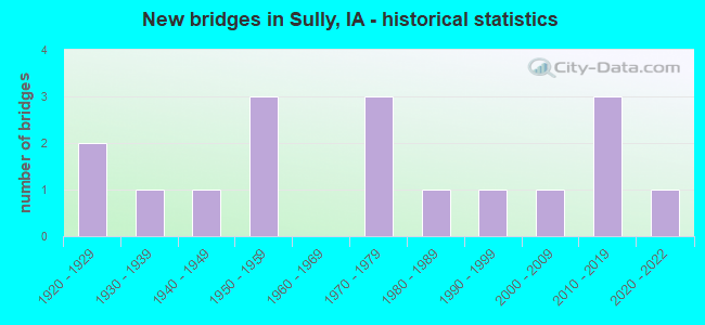
- New bridges - historical statistics
- 21920-1929
- 11930-1939
- 11940-1949
- 31950-1959
- 31970-1979
- 11980-1989
- 11990-1999
- 12000-2009
- 32010-2019
- 12020-2022

- Bridge Condition - Deck
- 6.7%Excellent
- 33.3%Very good
- 6.7%Good
- 13.3%Satisfactory
- 26.7%Fair
- 6.7%Poor
- 6.7%Failed

- Bridge Condition - Superstructure
- 6.7%Excellent
- 26.7%Very good
- 13.3%Good
- 20.0%Satisfactory
- 13.3%Fair
- 13.3%Poor
- 6.7%Failed

- Bridge Condition - Substructure
- 6.7%Excellent
- 33.3%Very good
- 6.7%Good
- 13.3%Satisfactory
- 13.3%Fair
- 13.3%Poor
- 6.7%Serious
- 6.7%Failed

- Bridge Condition - Channel
- 23.5%Very good
- 11.8%Good
- 35.3%Satisfactory
- 11.8%Fair
- 17.6%Poor

- Bridge Condition - Culverts
- 50.0%Fair
- 50.0%Poor
Find on map >> Show street view
Structure Number: 194996, Location: 078170404 (Lat: 41.599881, Lng: -92.824886), Route carried "on" structure: County highway , Year Built: 2018, Status: Open, Structure Length: 2.23m (7.32ft), Average Daily Traffic: 40 (year 2014), Average Future Daily Traffic: 40 (year 2041), Features Intersected: SLATER CREEK, Facility Carried by Structure: E 132ND ST S
Minimum Vertical Clearance: 30+ m (98+ ft), Kilometerpoint: 2.615, Lanes on structure: 2, Owner: County Highway Agency, Approaching Roadway Width: 7.6m (24.9ft), Material/Design: Steel, Design/Construction: Stringer/Multi-beam, Number Of Spans In Main Unit: 1, Length of Maximum Span: 21.0m (68.9ft), Curb-To-Curb Width: 7.3m (24.0ft), Out-to-Out Width: 7.5m (24.6ft)
Condition: Deck: Very good, Superstructure: Very good, Substructure: Very good, Channel: Very good, Operating Rating: 66.0 metric tons, Method Used To Determine Operating Rating: Load Factor (LF), Inventory Rating: 39.5 metric tons, Method Used To Determine Inventory Rating: Load Factor (LF), Structural Evaluation: Equal to present desirable criteria, Deck Geometry: Equal to present minimum criteria, Waterway Adequacy: Equal to present desirable criteria, Approach Roadway Alignment: Equal to present minimum criteria, Designated Inspection Frequency: Every 48 months, Inspection Date: April 2021, Deck Structure Type: Concrete Cast-file-Place, Wearing Surface/Protective System: Wearing Surface: Monolithic Concrete
Find on map >> Show street view
Structure Number: 195101, Location: 078171904 (Lat: 41.541261, Lng: -92.862869), Route carried "on" structure: County highway , Year Built: 2017, Status: Open, Structure Length: 1.52m (4.99ft), Average Daily Traffic: 20 (year 2014), Average Future Daily Traffic: 20 (year 2041), Features Intersected: SMALL STREAM, Facility Carried by Structure: E 116TH ST S
Minimum Vertical Clearance: 30+ m (98+ ft), Kilometerpoint: 0.414, Lanes on structure: 2, Owner: County Highway Agency, Approaching Roadway Width: 9.1m (29.9ft), Material/Design: Steel, Design/Construction: Slab, Number Of Spans In Main Unit: 1, Length of Maximum Span: 14.6m (47.9ft), Curb-To-Curb Width: 7.4m (24.3ft), Out-to-Out Width: 7.6m (24.9ft)
Condition: Deck: Very good, Superstructure: Very good, Substructure: Very good, Channel: Very good, Operating Rating: 61.5 metric tons, Method Used To Determine Operating Rating: Load Factor (LF), Inventory Rating: 36.8 metric tons, Method Used To Determine Inventory Rating: Load Factor (LF), Structural Evaluation: Equal to present desirable criteria, Deck Geometry: Equal to present minimum criteria, Waterway Adequacy: Equal to present desirable criteria, Approach Roadway Alignment: Equal to present minimum criteria, Designated Inspection Frequency: Every 48 months, Inspection Date: April 2021, Deck Structure Type: Concrete Cast-file-Place, Wearing Surface/Protective System: Wearing Surface: Gravel
Find on map >> Show street view
Structure Number: 195161, Location: 078173101 (Lat: 41.523092, Lng: -92.853608), Route carried "on" structure: County highway , Year Built: 2000, Status: Open, Structure Length: 1.80m (5.91ft), Average Daily Traffic: 10 (year 2014), Average Future Daily Traffic: 10 (year 2039), Design Load: HS 20, Features Intersected: BUCKLEY CREEK, Facility Carried by Structure: S 120TH AVE E
Minimum Vertical Clearance: 30+ m (98+ ft), Kilometerpoint: 6.705, Lanes on structure: 2, Owner: County Highway Agency, Approaching Roadway Width: 7.0m (23.0ft), Material/Design: Steel, Design/Construction: Stringer/Multi-beam, Number Of Spans In Main Unit: 1, Length of Maximum Span: 17.7m (58.1ft), Curb-To-Curb Width: 7.6m (24.9ft), Out-to-Out Width: 7.9m (25.9ft)
Condition: Deck: Very good, Superstructure: Very good, Substructure: Very good, Channel: Satisfactory, Operating Rating: 61.4 metric tons, Method Used To Determine Operating Rating: Allowable Stress (AS), Inventory Rating: 39.5 metric tons, Method Used To Determine Inventory Rating: Allowable Stress (AS), Structural Evaluation: Equal to present desirable criteria, Deck Geometry: Equal to present minimum criteria, Waterway Adequacy: Equal to present minimum criteria, Approach Roadway Alignment: Equal to present minimum criteria, Designated Inspection Frequency: Every 48 months, Inspection Date: March 2019, Deck Structure Type: Concrete Cast-file-Place, Wearing Surface/Protective System: Wearing Surface: Monolithic Concrete
Find on map >> Show street view
Structure Number: 195191, Location: 078173204 (Lat: 41.520464, Lng: -92.848208), Route carried "on" structure: County highway , Year Built: 2020, Status: Open, Structure Length: 2.13m (6.99ft), Average Daily Traffic: 45 (year 2014), Average Future Daily Traffic: 45 (year 2041), Features Intersected: BUCKLEY CREEK, Facility Carried by Structure: E 122ND ST S
Minimum Vertical Clearance: 30+ m (98+ ft), Kilometerpoint: 1.316, Lanes on structure: 2, Owner: County Highway Agency, Approaching Roadway Width: 6.7m (22.0ft), Material/Design: Steel, Design/Construction: Stringer/Multi-beam, Number Of Spans In Main Unit: 1, Length of Maximum Span: 21.0m (68.9ft), Curb-To-Curb Width: 7.3m (24.0ft), Out-to-Out Width: 7.5m (24.6ft)
Condition: Deck: Excellent, Superstructure: Excellent, Substructure: Excellent, Channel: Very good, Operating Rating: 66.0 metric tons, Method Used To Determine Operating Rating: Load Factor (LF), Inventory Rating: 39.5 metric tons, Method Used To Determine Inventory Rating: Load Factor (LF), Structural Evaluation: Superior to present desirable criteria, Deck Geometry: Equal to present minimum criteria, Waterway Adequacy: Equal to present desirable criteria, Approach Roadway Alignment: Better than present minimum criteria, Designated Inspection Frequency: Every 24 months, Inspection Date: April 2021, Deck Structure Type: Concrete Cast-file-Place, Wearing Surface/Protective System: Wearing Surface: Monolithic Concrete
Find on map >> Show street view
Structure Number: 195201, Location: 078173205 (Lat: 41.523122, Lng: -92.834564), Route carried "on" structure: County highway , Year Built: 1988, Status: Posted for load, Structure Length: 1.28m (4.20ft), Average Daily Traffic: 25 (year 2014), Average Future Daily Traffic: 25 (year 2041), Features Intersected: SMALL STREAM, Facility Carried by Structure: S 120TH AVE E
Minimum Vertical Clearance: 30+ m (98+ ft), Kilometerpoint: 8.293, Lanes on structure: 2, Owner: County Highway Agency, Approaching Roadway Width: 7.0m (23.0ft), Material/Design: Steel, Design/Construction: Stringer/Multi-beam, Number Of Spans In Main Unit: 1, Length of Maximum Span: 12.5m (41.0ft), Curb-To-Curb Width: 5.8m (19.0ft), Out-to-Out Width: 6.1m (20.0ft)
Condition: Deck: Satisfactory, Superstructure: Fair, Substructure: Fair, Channel: Good, Operating Rating: 33.4 metric tons, Method Used To Determine Operating Rating: Load Factor (LF), Inventory Rating: 20.0 metric tons, Method Used To Determine Inventory Rating: Load Factor (LF), Structural Evaluation: Somewhat better than minimum adequacy, Deck Geometry: Meets minimum limits, Waterway Adequacy: Better than present minimum criteria, Approach Roadway Alignment: Better than present minimum criteria, Bridge Posting: Required (Relationship of Operating Rating to Maximum Legal Load: 0.1 - 9.9% below), Length Of Structure Improvement: 5.00m (16.40ft), Designated Inspection Frequency: Every 24 months, Inspection Date: April 2021, Bridge Improvement Cost: $30,000, Roadway Improvement Cost: $7,000, Deck Structure Type: Wood or Timber, Wearing Surface/Protective System: Wearing Surface: Gravel
Find on map >> Show street view
Structure Number: 195401, Location: 078182205 (Lat: 41.551903, Lng: -92.911594), Route carried "on" structure: County highway , Year Built: 1979, Status: Open, Structure Length: 4.60m (15.09ft), Average Daily Traffic: 80 (year 2018), Average Future Daily Traffic: 80 (year 2039), Design Load: H 20, Features Intersected: ELK CREEK, Facility Carried by Structure: S 104TH AVE E
Minimum Vertical Clearance: 30+ m (98+ ft), Kilometerpoint: 3.407, Lanes on structure: 2, Owner: County Highway Agency, Approaching Roadway Width: 9.1m (29.9ft), Skew: 1 degrees, Material/Design: Prestressed concrete, Design/Construction: Stringer/Multi-beam, Number Of Spans In Main Unit: 3, Length of Maximum Span: 16.8m (55.1ft), Curb-To-Curb Width: 9.1m (29.9ft), Out-to-Out Width: 9.8m (32.2ft)
Condition: Deck: Good, Superstructure: Good, Substructure: Good, Channel: Satisfactory, Operating Rating: 69.0 metric tons, Method Used To Determine Operating Rating: Allowable Stress (AS), Inventory Rating: 32.8 metric tons, Method Used To Determine Inventory Rating: Allowable Stress (AS), Structural Evaluation: Better than present minimum criteria, Deck Geometry: Better than present minimum criteria, Waterway Adequacy: Better than present minimum criteria, Approach Roadway Alignment: Equal to present minimum criteria, Length Of Structure Improvement: 17.50m (57.41ft), Designated Inspection Frequency: Every 48 months, Inspection Date: March 2019, Bridge Improvement Cost: $350,000, Roadway Improvement Cost: $40,000, Deck Structure Type: Concrete Cast-file-Place, Wearing Surface/Protective System: Wearing Surface: Monolithic Concrete
Find on map >> Show street view
Structure Number: 19541, Location: 078182303 (Lat: 41.551906, Lng: -92.893519), Route carried "on" structure: County highway , Year Built: 1932, Year Reconstructed: 1988, Status: Posted for load, Structure Length: 1.31m (4.30ft), Average Daily Traffic: 20 (year 2014), Average Future Daily Traffic: 20 (year 2041), Design Load: H 10, Features Intersected: LITTLE ELK CREEK, Facility Carried by Structure: S 104TH AVE E
Minimum Vertical Clearance: 30+ m (98+ ft), Kilometerpoint: 4.915, Lanes on structure: 2, Owner: County Highway Agency, Approaching Roadway Width: 7.6m (24.9ft), Material/Design: Steel, Design/Construction: Stringer/Multi-beam, Number Of Spans In Main Unit: 1, Length of Maximum Span: 12.8m (42.0ft), Curb-To-Curb Width: 6.4m (21.0ft), Out-to-Out Width: 6.7m (22.0ft)
Condition: Deck: Satisfactory, Superstructure: Satisfactory, Substructure: Poor, Channel: Satisfactory, Operating Rating: 23.9 metric tons, Method Used To Determine Operating Rating: Allowable Stress (AS), Inventory Rating: 15.7 metric tons, Method Used To Determine Inventory Rating: Allowable Stress (AS), Structural Evaluation: Meets minimum limits, Deck Geometry: Somewhat better than minimum adequacy, Waterway Adequacy: Equal to present minimum criteria, Approach Roadway Alignment: Better than present minimum criteria, Bridge Posting: Required (Relationship of Operating Rating to Maximum Legal Load: 20.0 - 29.9% below), Length Of Structure Improvement: 5.00m (16.40ft), Designated Inspection Frequency: Every 24 months, Inspection Date: April 2021, Bridge Improvement Cost: $130,000, Roadway Improvement Cost: $15,000, Deck Structure Type: Wood or Timber, Wearing Surface/Protective System: Wearing Surface: Gravel
Find on map >> Show street view
Structure Number: 19544, Location: 078182601 (Lat: 41.537419, Lng: -92.902183), Route carried "on" structure: County highway , Year Built: 1948, Status: Closed, Structure Length: 1.31m (4.30ft), Average Daily Traffic: 15 (year 2014), Average Future Daily Traffic: 15 (year 2041), Design Load: HS 20, Features Intersected: ELK CREEK, Facility Carried by Structure: S 112TH AVE E
Minimum Vertical Clearance: 30+ m (98+ ft), Kilometerpoint: 4.849, Lanes on structure: 2, Owner: County Highway Agency, Approaching Roadway Width: 6.7m (22.0ft), Material/Design: Steel, Design/Construction: Stringer/Multi-beam, Number Of Spans In Main Unit: 1, Length of Maximum Span: 12.2m (40.0ft), Curb-To-Curb Width: 5.5m (18.0ft), Out-to-Out Width: 5.6m (18.4ft)
Condition: Deck: Failed, Superstructure: Failed, Substructure: Failed, Channel: Satisfactory, Deck Geometry: Meets minimum limits, Waterway Adequacy: Somewhat better than minimum adequacy, Approach Roadway Alignment: Equal to present minimum criteria, Bridge Posting: Required (Relationship of Operating Rating to Maximum Legal Load: > 39.9% below), Length Of Structure Improvement: 17.60m (57.74ft), Designated Inspection Frequency: Every 12 months, Inspection Date: April 2021, Bridge Improvement Cost: $400,000, Roadway Improvement Cost: $40,000, Deck Structure Type: Wood or Timber, Wearing Surface/Protective System: Wearing Surface: Gravel
Find on map >> Show street view
Structure Number: 19545, Location: 078182601 (Lat: 41.537453, Lng: -92.892031), Route carried "on" structure: County highway , Year Built: 1954, Status: Posted for load, Structure Length: 1.31m (4.30ft), Average Daily Traffic: 15 (year 2014), Average Future Daily Traffic: 15 (year 2041), Design Load: H 10, Features Intersected: LITTLE ELK CREEK, Facility Carried by Structure: S 112TH AVE E
Minimum Vertical Clearance: 30+ m (98+ ft), Kilometerpoint: 5.695, Lanes on structure: 1, Owner: County Highway Agency, Approaching Roadway Width: 6.7m (22.0ft), Material/Design: Steel, Design/Construction: Stringer/Multi-beam, Number Of Spans In Main Unit: 1, Length of Maximum Span: 12.5m (41.0ft), Curb-To-Curb Width: 5.5m (18.0ft), Out-to-Out Width: 5.6m (18.4ft)
Condition: Deck: Fair, Superstructure: Satisfactory, Substructure: Serious, Channel: Satisfactory, Operating Rating: 9.0 metric tons, Method Used To Determine Operating Rating: Allowable Stress (AS), Inventory Rating: 5.4 metric tons, Method Used To Determine Inventory Rating: Allowable Stress (AS), Structural Evaluation: High priority of replacement, Deck Geometry: Meets minimum limits, Waterway Adequacy: Equal to present minimum criteria, Approach Roadway Alignment: Equal to present minimum criteria, Bridge Posting: Required (Relationship of Operating Rating to Maximum Legal Load: > 39.9% below), Length Of Structure Improvement: 5.00m (16.40ft), Designated Inspection Frequency: Every 12 months, Inspection Date: April 2021, Bridge Improvement Cost: $120,000, Roadway Improvement Cost: $15,000, Deck Structure Type: Wood or Timber, Wearing Surface/Protective System: Wearing Surface: Gravel
Find on map >> Show street view
Structure Number: 19637, Location: 079172204 (Lat: 41.630933, Lng: -92.824561), Route carried "on" structure: County highway , Year Built: 1952, Status: Open, Structure Length: 0.73m (2.40ft), Average Daily Traffic: 30 (year 2014), Average Future Daily Traffic: 30 (year 2041), Design Load: H 15, Features Intersected: SMALL STREAM, Facility Carried by Structure: E 132ND ST S
Minimum Vertical Clearance: 30+ m (98+ ft), Kilometerpoint: 6.088, Lanes on structure: 2, Owner: County Highway Agency, Approaching Roadway Width: 9.1m (29.9ft), Skew: 3 degrees, Material/Design: Concrete continuous, Design/Construction: Culvert, Number Of Spans In Main Unit: 2, Length of Maximum Span: 3.4m (11.2ft)
Condition: Channel: Poor, Culverts: Poor, Operating Rating: 86.7 metric tons, Method Used To Determine Operating Rating: Load Factor (LF), Inventory Rating: 51.9 metric tons, Method Used To Determine Inventory Rating: Load Factor (LF), Structural Evaluation: Meets minimum limits, Waterway Adequacy: Meets minimum limits, Approach Roadway Alignment: Equal to present minimum criteria, Length Of Structure Improvement: 5.10m (16.73ft), Designated Inspection Frequency: Every 24 months, Inspection Date: April 2021, Bridge Improvement Cost: $30,000, Roadway Improvement Cost: $5,000
Find on map >> Show street view
Structure Number: 19644, Location: 079172902 (Lat: 41.620333, Lng: -92.863183), Route carried "on" structure: County highway , Year Built: 1926, Status: Posted for load, Structure Length: 0.67m (2.20ft), Average Daily Traffic: 15 (year 2014), Average Future Daily Traffic: 15 (year 2041), Features Intersected: SMALL STREAM, Facility Carried by Structure: E 116TH ST S
Minimum Vertical Clearance: 30+ m (98+ ft), Kilometerpoint: 2.868, Lanes on structure: 2, Owner: County Highway Agency, Approaching Roadway Width: 6.4m (21.0ft), Material/Design: Concrete, Design/Construction: Slab, Number Of Spans In Main Unit: 1, Length of Maximum Span: 6.1m (20.0ft), Curb-To-Curb Width: 5.5m (18.0ft), Out-to-Out Width: 6.2m (20.3ft)
Condition: Deck: Poor, Superstructure: Poor, Substructure: Fair, Channel: Poor, Operating Rating: 31.9 metric tons, Method Used To Determine Operating Rating: Allowable Stress (AS), Inventory Rating: 12.3 metric tons, Method Used To Determine Inventory Rating: Allowable Stress (AS), Structural Evaluation: Meets minimum limits, Deck Geometry: Meets minimum limits, Waterway Adequacy: Equal to present minimum criteria, Approach Roadway Alignment: Equal to present minimum criteria, Bridge Posting: Required (Relationship of Operating Rating to Maximum Legal Load: 10.0 - 19.9% below), Length Of Structure Improvement: 5.00m (16.40ft), Designated Inspection Frequency: Every 24 months, Inspection Date: April 2021, Bridge Improvement Cost: $105,000, Roadway Improvement Cost: $15,000, Deck Structure Type: Concrete Cast-file-Place, Wearing Surface/Protective System: Wearing Surface: Gravel
Find on map >> Show street view
Structure Number: 196462, Location: 079173104 (Lat: 41.612369, Lng: -92.877719), Route carried "on" structure: County highway , Year Built: 1999, Status: Open, Structure Length: 2.01m (6.59ft), Average Daily Traffic: 60 (year 2014), Average Future Daily Traffic: 60 (year 2039), Design Load: HS 20, Features Intersected: SLATER CREEK, Facility Carried by Structure: E 110TH ST S
Minimum Vertical Clearance: 30+ m (98+ ft), Kilometerpoint: 2.726, Lanes on structure: 2, Owner: County Highway Agency, Approaching Roadway Width: 6.7m (22.0ft), Material/Design: Steel, Design/Construction: Stringer/Multi-beam, Number Of Spans In Main Unit: 1, Length of Maximum Span: 19.5m (64.0ft), Curb-To-Curb Width: 7.2m (23.6ft), Out-to-Out Width: 7.2m (23.6ft)
Condition: Deck: Very good, Superstructure: Good, Substructure: Very good, Channel: Good, Inventory Rating: 57.5 metric tons, Method Used To Determine Inventory Rating: Load Factor (LF), Structural Evaluation: Better than present minimum criteria, Deck Geometry: Somewhat better than minimum adequacy, Waterway Adequacy: Better than present minimum criteria, Approach Roadway Alignment: Equal to present minimum criteria, Designated Inspection Frequency: Every 48 months, Inspection Date: March 2019, Deck Structure Type: Concrete Cast-file-Place
Find on map >> Show street view
Structure Number: 196491, Location: 079173302 (Lat: 41.603681, Lng: -92.843714), Route carried "on" structure: County highway , Year Built: 1976, Status: Open, Structure Length: 2.68m (8.79ft), Average Daily Traffic: 870 (year 2018), Truck Traffic: 16%, Average Future Daily Traffic: 870 (year 2041), Design Load: H 20, Features Intersected: SLATER CREEK, Facility Carried by Structure: E 124TH ST S
Minimum Vertical Clearance: 30+ m (98+ ft), Kilometerpoint: 2.512, Lanes on structure: 2, Owner: County Highway Agency, Approaching Roadway Width: 8.5m (27.9ft), Material/Design: Concrete continuous, Design/Construction: Slab, Number Of Spans In Main Unit: 3, Length of Maximum Span: 10.4m (34.1ft), Curb-To-Curb Width: 9.1m (29.9ft), Out-to-Out Width: 9.8m (32.2ft)
Condition: Deck: Fair, Superstructure: Fair, Substructure: Satisfactory, Channel: Fair, Operating Rating: 48.5 metric tons, Method Used To Determine Operating Rating: Allowable Stress (AS), Inventory Rating: 30.4 metric tons, Method Used To Determine Inventory Rating: Allowable Stress (AS), Structural Evaluation: Somewhat better than minimum adequacy, Deck Geometry: Equal to present minimum criteria, Waterway Adequacy: Equal to present minimum criteria, Approach Roadway Alignment: Equal to present minimum criteria, Length Of Structure Improvement: 10.00m (32.81ft), Designated Inspection Frequency: Every 24 months, Inspection Date: April 2021, Bridge Improvement Cost: $300,000, Roadway Improvement Cost: $40,000, Deck Structure Type: Concrete Cast-file-Place, Wearing Surface/Protective System: Wearing Surface: Monolithic Concrete
Find on map >> Show street view
Structure Number: 196501, Location: 079173302 (Lat: 41.613289, Lng: -92.843711), Route carried "on" structure: County highway , Year Built: 1976, Status: Open, Structure Length: 0.67m (2.20ft), Average Daily Traffic: 870 (year 2018), Truck Traffic: 16%, Average Future Daily Traffic: 870 (year 2041), Features Intersected: SMALL STREAM, Facility Carried by Structure: E 124TH ST S
Minimum Vertical Clearance: 30+ m (98+ ft), Kilometerpoint: 3.578, Lanes on structure: 2, Owner: County Highway Agency, Approaching Roadway Width: 10.4m (34.1ft), Skew: 1 degrees, Material/Design: Concrete continuous, Design/Construction: Culvert, Number Of Spans In Main Unit: 2, Length of Maximum Span: 3.0m (9.8ft)
Condition: Channel: Satisfactory, Culverts: Fair, Operating Rating: 30.8 metric tons, Method Used To Determine Operating Rating: Field evaluation and documented engineering judgment, Inventory Rating: 22.7 metric tons, Method Used To Determine Inventory Rating: Field evaluation and documented engineering judgment, Structural Evaluation: Somewhat better than minimum adequacy, Waterway Adequacy: Somewhat better than minimum adequacy, Approach Roadway Alignment: Better than present minimum criteria, Length Of Structure Improvement: 9.20m (30.18ft), Designated Inspection Frequency: Every 24 months, Inspection Date: April 2021, Bridge Improvement Cost: $260,000, Roadway Improvement Cost: $40,000
Find on map >> Show street view
Structure Number: 19651, Location: 079173401 (Lat: 41.615992, Lng: -92.816397), Route carried "on" structure: County highway , Year Built: 1955, Status: Open, Structure Length: 9.81m (32.19ft), Average Daily Traffic: 25 (year 2018), Average Future Daily Traffic: 25 (year 2041), Design Load: H 15, Features Intersected: N SKUNK RIVER, Facility Carried by Structure: S 68TH AVE E
Minimum Vertical Clearance: 30+ m (98+ ft), Kilometerpoint: 13.744, Lanes on structure: 2, Owner: County Highway Agency, Approaching Roadway Width: 7.9m (25.9ft), Skew: 3 degrees, Material/Design: Steel continuous, Design/Construction: Stringer/Multi-beam, Number Of Spans In Main Unit: 3, Number Of Approach Spans: 1, Length of Maximum Span: 29.6m (97.1ft), Curb-To-Curb Width: 6.2m (20.3ft), Out-to-Out Width: 6.7m (22.0ft)
Condition: Deck: Fair, Superstructure: Satisfactory, Substructure: Satisfactory, Channel: Fair, Operating Rating: 26.7 metric tons, Method Used To Determine Operating Rating: Load Factor (LF), Inventory Rating: 16.0 metric tons, Method Used To Determine Inventory Rating: Load Factor (LF), Structural Evaluation: Meets minimum limits, Deck Geometry: Somewhat better than minimum adequacy, Waterway Adequacy: Equal to present minimum criteria, Approach Roadway Alignment: Equal to present minimum criteria, Length Of Structure Improvement: 32.50m (106.63ft), Designated Inspection Frequency: Every 24 months, Underwater Inspection Frequency: Every 48 months, Inspection Date: April 2021, Underwater Inspection Date: October 2020, Bridge Improvement Cost: $500,000, Roadway Improvement Cost: $50,000, Deck Structure Type: Concrete Cast-file-Place, Wearing Surface/Protective System: Wearing Surface: Monolithic Concrete
Find on map >> Show street view
Structure Number: 196521, Location: 079173404 (Lat: 41.606783, Lng: -92.824564), Route carried "on" structure: County highway , Year Built: 2018, Status: Open, Structure Length: 1.59m (5.22ft), Average Daily Traffic: 40 (year 2014), Average Future Daily Traffic: 40 (year 2040), Features Intersected: SMALL STREAM, Facility Carried by Structure: E 132ND ST S
Minimum Vertical Clearance: 30+ m (98+ ft), Kilometerpoint: 3.384, Lanes on structure: 2, Owner: County Highway Agency, Approaching Roadway Width: 7.9m (25.9ft), Material/Design: Steel, Design/Construction: Slab, Number Of Spans In Main Unit: 1, Length of Maximum Span: 14.9m (48.9ft), Curb-To-Curb Width: 7.5m (24.6ft), Out-to-Out Width: 7.6m (24.9ft)
Condition: Deck: Very good, Superstructure: Very good, Substructure: Very good, Channel: Very good, Operating Rating: 57.6 metric tons, Method Used To Determine Operating Rating: Load Factor (LF), Inventory Rating: 34.5 metric tons, Method Used To Determine Inventory Rating: Load Factor (LF), Structural Evaluation: Equal to present desirable criteria, Deck Geometry: Equal to present minimum criteria, Waterway Adequacy: Equal to present desirable criteria, Approach Roadway Alignment: Equal to present minimum criteria, Designated Inspection Frequency: Every 24 months, Inspection Date: March 2020, Deck Structure Type: Concrete Cast-file-Place, Wearing Surface/Protective System: Wearing Surface: Monolithic Concrete
Find on map >> Show street view
Structure Number: 19681, Location: 079183601 (Lat: 41.616383, Lng: -92.886897), Route carried "on" structure: County highway , Year Built: 1927, Status: Posted for load, Structure Length: 1.01m (3.31ft), Average Daily Traffic: 70 (year 2018), Average Future Daily Traffic: 70 (year 2041), Features Intersected: SLATER CREEK, Facility Carried by Structure: S 68TH AVE E
Minimum Vertical Clearance: 30+ m (98+ ft), Kilometerpoint: 7.868, Lanes on structure: 2, Owner: County Highway Agency, Approaching Roadway Width: 7.0m (23.0ft), Material/Design: Steel, Design/Construction: Stringer/Multi-beam, Number Of Spans In Main Unit: 1, Length of Maximum Span: 9.8m (32.2ft), Curb-To-Curb Width: 5.5m (18.0ft), Out-to-Out Width: 6.1m (20.0ft)
Condition: Deck: Fair, Superstructure: Poor, Substructure: Poor, Channel: Poor, Operating Rating: 22.5 metric tons, Method Used To Determine Operating Rating: Allowable Stress (AS), Inventory Rating: 7.3 metric tons, Method Used To Determine Inventory Rating: Allowable Stress (AS), Structural Evaluation: High priority of replacement, Waterway Adequacy: Equal to present minimum criteria, Approach Roadway Alignment: Somewhat better than minimum adequacy, Bridge Posting: Required (Relationship of Operating Rating to Maximum Legal Load: 20.0 - 29.9% below), Length Of Structure Improvement: 5.00m (16.40ft), Designated Inspection Frequency: Every 24 months, Inspection Date: April 2021, Bridge Improvement Cost: $160,000, Roadway Improvement Cost: $20,000, Deck Structure Type: Concrete Cast-file-Place, Wearing Surface/Protective System: Wearing Surface: Gravel