Bridge Statistics for Summit, Arizona (AZ)
Condition, Traffic, Stress, Structural Evaluation, Project Costs
- National Bridge Inventory (NBI) Statistics
- 20Number of bridges
- 112ft / 33.8mTotal length
- $2,000Total costs
- 390,142Total average daily traffic
- 65,564Total average daily truck traffic
- National Bridge Inventory (NBI) Registered Bridges for Summit
- No street view available for this location
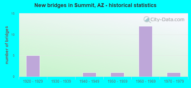
- New bridges - historical statistics
- 51920-1929
- 11940-1949
- 11950-1959
- 121960-1969
- 11970-1979

- Reconstructed bridges - Historical Statistics
- 41930-1939
- 11940-1949
- 01950-1959
- 01960-1969
- 01970-1979
- 31980-1989


- Bridge Condition - Deck
- 90.0%Satisfactory
- 10.0%Fair

- Bridge Condition - Substructure
- 40.0%Good
- 60.0%Satisfactory

- Bridge Condition - Channel
- 7.1%Very good
- 28.6%Good
- 35.7%Satisfactory
- 28.6%Fair

- Bridge Condition - Culverts
- 87.5%Good
- 12.5%Satisfactory
Find on map >> Show street view
Structure Number: 1305, Location: 9.8 mi North of Jct B 19 (Lat: 32.051700, Lng: -110.992600), Route carried "on" structure: Interstate 19, Year Built: 1968, Status: Open, Structure Length: 2.10m (6.89ft), Average Daily Traffic: 23,434 (year 2018), Truck Traffic: 20%, Average Future Daily Traffic: 23,444 (year 2038), Design Load: HS 20, Features Intersected: Old road
Minimum Vertical Clearance: 30+ m (98+ ft), Kilometerpoint: 85.490, Lanes on structure: 2, Owner: State Highway Agency, Approaching Roadway Width: 11.6m (38.1ft), Material/Design: Concrete continuous, Design/Construction: Slab, Number Of Spans In Main Unit: 3, Length of Maximum Span: 7.6m (24.9ft), Curb-To-Curb Width: 11.6m (38.1ft), Out-to-Out Width: 12.3m (40.4ft)
Condition: Deck: Satisfactory, Superstructure: Satisfactory, Substructure: Good, Operating Rating: 50.8 metric tons, Method Used To Determine Operating Rating: Load Factor (LF), Inventory Rating: 29.9 metric tons, Method Used To Determine Inventory Rating: Load Factor (LF), Structural Evaluation: Equal to present minimum criteria, Deck Geometry: Equal to present minimum criteria, Approach Roadway Alignment: Equal to present desirable criteria, Designated Inspection Frequency: Every 24 months, Inspection Date: September 2021, Deck Structure Type: Concrete Cast-file-Place, Wearing Surface/Protective System: Wearing Surface: Bituminous
Find on map >> Show street view
Structure Number: 1306, Location: 9.8 mi North of Jct B 19 (Lat: 32.051600, Lng: -110.993000), Route carried "on" structure: Interstate 19, Year Built: 1968, Status: Open, Structure Length: 2.10m (6.89ft), Average Daily Traffic: 24,198 (year 2018), Truck Traffic: 20%, Average Future Daily Traffic: 24,208 (year 2038), Design Load: HS 20, Features Intersected: Old road
Minimum Vertical Clearance: 30+ m (98+ ft), Kilometerpoint: 85.456, Lanes on structure: 2, Owner: State Highway Agency, Approaching Roadway Width: 11.6m (38.1ft), Material/Design: Concrete continuous, Design/Construction: Slab, Number Of Spans In Main Unit: 3, Length of Maximum Span: 7.6m (24.9ft), Curb-To-Curb Width: 11.6m (38.1ft), Out-to-Out Width: 12.3m (40.4ft)
Condition: Deck: Satisfactory, Superstructure: Satisfactory, Substructure: Good, Operating Rating: 50.8 metric tons, Method Used To Determine Operating Rating: Load Factor (LF), Inventory Rating: 29.9 metric tons, Method Used To Determine Inventory Rating: Load Factor (LF), Structural Evaluation: Equal to present minimum criteria, Deck Geometry: Equal to present minimum criteria, Approach Roadway Alignment: Equal to present desirable criteria, Designated Inspection Frequency: Every 24 months, Inspection Date: September 2021, Deck Structure Type: Concrete Cast-file-Place, Wearing Surface/Protective System: Wearing Surface: Bituminous
Find on map >> Show street view
Structure Number: 1307, Location: 8.7 mi S Jct I 10 (Lat: 32.070300, Lng: -110.992900), Route carried "on" structure: Interstate 19, Year Built: 1968, Status: Open, Structure Length: 3.75m (12.30ft), Average Daily Traffic: 23,612 (year 2018), Truck Traffic: 19%, Average Future Daily Traffic: 23,622 (year 2038), Design Load: HS 20, Features Intersected: Papago Rd
Minimum Vertical Clearance: 30+ m (98+ ft), Kilometerpoint: 87.548, Lanes on structure: 2, Lanes under structure: 2, Owner: State Highway Agency, Approaching Roadway Width: 11.6m (38.1ft), Material/Design: Concrete continuous, Design/Construction: Tee Beam, Number Of Spans In Main Unit: 3, Length of Maximum Span: 15.2m (49.9ft), Curb-To-Curb Width: 11.6m (38.1ft), Out-to-Out Width: 12.4m (40.7ft)
Condition: Deck: Satisfactory, Superstructure: Satisfactory, Substructure: Good, Operating Rating: 63.5 metric tons, Method Used To Determine Operating Rating: Load Factor (LF), Inventory Rating: 38.1 metric tons, Method Used To Determine Inventory Rating: Load Factor (LF), Structural Evaluation: Equal to present minimum criteria, Deck Geometry: Equal to present minimum criteria, Underclear: Equal to present minimum criteria, Approach Roadway Alignment: Equal to present desirable criteria, Designated Inspection Frequency: Every 24 months, Inspection Date: September 2021, Deck Structure Type: Concrete Cast-file-Place, Wearing Surface/Protective System: Wearing Surface: Bituminous
Find on map >> Show street view
Structure Number: 1308, Location: 8.7 mi S Jct I 10 (Lat: 32.070200, Lng: -110.993200), Route carried "on" structure: Interstate 19, Year Built: 1968, Status: Open, Structure Length: 3.75m (12.30ft), Average Daily Traffic: 25,314 (year 2018), Truck Traffic: 19%, Average Future Daily Traffic: 25,324 (year 2038), Design Load: HS 20, Features Intersected: Papago Rd
Minimum Vertical Clearance: 30+ m (98+ ft), Kilometerpoint: 87.548, Lanes on structure: 2, Lanes under structure: 2, Owner: State Highway Agency, Approaching Roadway Width: 11.6m (38.1ft), Material/Design: Concrete continuous, Design/Construction: Tee Beam, Number Of Spans In Main Unit: 3, Length of Maximum Span: 15.2m (49.9ft), Curb-To-Curb Width: 11.6m (38.1ft), Out-to-Out Width: 12.4m (40.7ft)
Condition: Deck: Satisfactory, Superstructure: Satisfactory, Substructure: Good, Operating Rating: 63.5 metric tons, Method Used To Determine Operating Rating: Load Factor (LF), Inventory Rating: 38.1 metric tons, Method Used To Determine Inventory Rating: Load Factor (LF), Structural Evaluation: Equal to present minimum criteria, Deck Geometry: Equal to present minimum criteria, Underclear: Equal to present minimum criteria, Approach Roadway Alignment: Equal to present desirable criteria, Designated Inspection Frequency: Every 24 months, Inspection Date: September 2021, Deck Structure Type: Concrete Cast-file-Place, Wearing Surface/Protective System: Wearing Surface: Bituminous
Find on map >> Show street view
Structure Number: 5819, Location: 9.3 m N Jct B 19 (Lat: 32.044944, Lng: -110.992750), Route carried "on" structure: Interstate 19, Year Built: 1968, Year Reconstructed: 1985, Status: Open, Structure Length: 0.73m (2.40ft), Average Daily Traffic: 41,630 (year 2014), Truck Traffic: 21%, Average Future Daily Traffic: 41,640 (year 2034), Design Load: HS 20, Features Intersected: Wash
Minimum Vertical Clearance: 30+ m (98+ ft), Kilometerpoint: 84.587, Lanes on structure: 4, Owner: State Highway Agency, Approaching Roadway Width: 23.2m (76.1ft), Skew: 33 degrees, Material/Design: Concrete continuous, Design/Construction: Culvert, Number Of Spans In Main Unit: 2, Length of Maximum Span: 3.0m (9.8ft), Curb or Sidewalk Widths: Left: 0.3m (1.0ft), Right: 0.3m (1.0ft), Curb-To-Curb Width: 23.2m (76.1ft), Out-to-Out Width: 59.4m (194.9ft)
Condition: Channel: Satisfactory, Culverts: Good, Operating Rating: 53.5 metric tons, Method Used To Determine Operating Rating: Load Factor (LF), Inventory Rating: 31.8 metric tons, Method Used To Determine Inventory Rating: Load Factor (LF), Structural Evaluation: Better than present minimum criteria, Deck Geometry: Superior to present desirable criteria, Waterway Adequacy: Equal to present desirable criteria, Approach Roadway Alignment: Equal to present desirable criteria, Designated Inspection Frequency: Every 48 months, Inspection Date: January 2020, Deck Structure Type: Concrete Cast-file-Place, Wearing Surface/Protective System: Wearing Surface: Bituminous
Find on map >> Show street view
Structure Number: 582, Location: 10.5 mi N Jct B 19 (Lat: 32.060389, Lng: -110.992750), Route carried "on" structure: Interstate 19, Year Built: 1968, Status: Open, Structure Length: 1.65m (5.41ft), Average Daily Traffic: 21,005 (year 2014), Truck Traffic: 21%, Average Future Daily Traffic: 21,015 (year 2034), Design Load: HS 20, Features Intersected: Wash
Minimum Vertical Clearance: 30+ m (98+ ft), Kilometerpoint: 86.422, Lanes on structure: 2, Owner: State Highway Agency, Approaching Roadway Width: 11.6m (38.1ft), Material/Design: Concrete continuous, Design/Construction: Culvert, Number Of Spans In Main Unit: 5, Length of Maximum Span: 3.0m (9.8ft)
Condition: Channel: Good, Culverts: Good, Operating Rating: 89.8 metric tons, Method Used To Determine Operating Rating: Load Factor (LF), Inventory Rating: 89.8 metric tons, Method Used To Determine Inventory Rating: Load Factor (LF), Structural Evaluation: Better than present minimum criteria, Waterway Adequacy: Equal to present desirable criteria, Approach Roadway Alignment: Equal to present desirable criteria, Designated Inspection Frequency: Every 48 months, Inspection Date: January 2020
Find on map >> Show street view
Structure Number: 5821, Location: 10.5 mi N Jct B 19 (Lat: 32.060389, Lng: -110.993111), Route carried "on" structure: Interstate 19, Year Built: 1968, Status: Open, Structure Length: 1.65m (5.41ft), Average Daily Traffic: 20,625 (year 2014), Truck Traffic: 21%, Average Future Daily Traffic: 20,635 (year 2034), Design Load: HS 20, Features Intersected: Wash
Minimum Vertical Clearance: 30+ m (98+ ft), Kilometerpoint: 86.422, Lanes on structure: 2, Owner: State Highway Agency, Approaching Roadway Width: 11.6m (38.1ft), Material/Design: Concrete continuous, Design/Construction: Culvert, Number Of Spans In Main Unit: 5, Length of Maximum Span: 3.0m (9.8ft)
Condition: Channel: Good, Culverts: Good, Operating Rating: 89.8 metric tons, Method Used To Determine Operating Rating: Load Factor (LF), Inventory Rating: 89.8 metric tons, Method Used To Determine Inventory Rating: Load Factor (LF), Structural Evaluation: Better than present minimum criteria, Waterway Adequacy: Equal to present desirable criteria, Approach Roadway Alignment: Equal to present desirable criteria, Designated Inspection Frequency: Every 48 months, Inspection Date: January 2020
Find on map >> Show street view
Structure Number: 5823, Location: 9.3 mi S Jct 1-10 (Lat: 32.066500, Lng: -110.993000), Route carried "on" structure: Interstate 19, Year Built: 1968, Year Reconstructed: 1985, Status: Open, Structure Length: 1.37m (4.49ft), Average Daily Traffic: 41,630 (year 2014), Truck Traffic: 21%, Average Future Daily Traffic: 41,640 (year 2034), Design Load: HS 20, Features Intersected: Wash
Minimum Vertical Clearance: 30+ m (98+ ft), Kilometerpoint: 87.162, Lanes on structure: 4, Owner: State Highway Agency, Approaching Roadway Width: 23.2m (76.1ft), Skew: 34 degrees, Material/Design: Concrete continuous, Design/Construction: Culvert, Number Of Spans In Main Unit: 3, Length of Maximum Span: 3.0m (9.8ft)
Condition: Channel: Satisfactory, Culverts: Good, Operating Rating: 57.2 metric tons, Method Used To Determine Operating Rating: Load Factor (LF), Inventory Rating: 34.5 metric tons, Method Used To Determine Inventory Rating: Load Factor (LF), Structural Evaluation: Better than present minimum criteria, Waterway Adequacy: Equal to present desirable criteria, Approach Roadway Alignment: Equal to present desirable criteria, Length Of Structure Improvement: 2.04m (6.69ft), Designated Inspection Frequency: Every 48 months, Inspection Date: January 2020, Bridge Improvement Cost: $1,000, Total Project Cost: $2,000 ( Estimate for 2016)
Find on map >> Show street view
Structure Number: 5824, Location: 8.3 mi S Jct I 10 (Lat: 32.076000, Lng: -110.992917), Route carried "on" structure: Interstate 19, Year Built: 1967, Status: Open, Structure Length: 1.98m (6.50ft), Average Daily Traffic: 21,005 (year 2014), Truck Traffic: 21%, Average Future Daily Traffic: 21,015 (year 2034), Design Load: HS 20, Features Intersected: Wash
Minimum Vertical Clearance: 30+ m (98+ ft), Kilometerpoint: 88.160, Lanes on structure: 2, Owner: State Highway Agency, Approaching Roadway Width: 11.6m (38.1ft), Material/Design: Concrete continuous, Design/Construction: Culvert, Number Of Spans In Main Unit: 6, Length of Maximum Span: 3.0m (9.8ft), Curb-To-Curb Width: 13.7m (44.9ft), Out-to-Out Width: 16.8m (55.1ft)
Condition: Channel: Good, Culverts: Good, Operating Rating: 55.3 metric tons, Method Used To Determine Operating Rating: Load Factor (LF), Inventory Rating: 32.7 metric tons, Method Used To Determine Inventory Rating: Load Factor (LF), Structural Evaluation: Better than present minimum criteria, Deck Geometry: Superior to present desirable criteria, Waterway Adequacy: Equal to present desirable criteria, Approach Roadway Alignment: Equal to present desirable criteria, Designated Inspection Frequency: Every 48 months, Inspection Date: January 2020, Deck Structure Type: Concrete Cast-file-Place, Wearing Surface/Protective System: Wearing Surface: Bituminous
Find on map >> Show street view
Structure Number: 5826, Location: 8.1 mi S Jct I 10 (Lat: 32.079472, Lng: -110.993167), Route carried "on" structure: Interstate 19, Year Built: 1967, Year Reconstructed: 1989, Status: Open, Structure Length: 0.64m (2.10ft), Average Daily Traffic: 41,630 (year 2014), Truck Traffic: 21%, Average Future Daily Traffic: 41,640 (year 2034), Design Load: HS 20, Features Intersected: Wash
Minimum Vertical Clearance: 30+ m (98+ ft), Kilometerpoint: 88.546, Lanes on structure: 4, Owner: State Highway Agency, Approaching Roadway Width: 23.2m (76.1ft), Skew: 30 degrees, Material/Design: Concrete continuous, Design/Construction: Culvert, Number Of Spans In Main Unit: 2, Length of Maximum Span: 3.0m (9.8ft), Curb or Sidewalk Widths: Left: 0.3m (1.0ft), Right: 0.3m (1.0ft), Curb-To-Curb Width: 23.2m (76.1ft), Out-to-Out Width: 59.4m (194.9ft)
Condition: Channel: Very good, Culverts: Good, Operating Rating: 49.9 metric tons, Method Used To Determine Operating Rating: Load Factor (LF), Inventory Rating: 29.9 metric tons, Method Used To Determine Inventory Rating: Load Factor (LF), Structural Evaluation: Better than present minimum criteria, Deck Geometry: Superior to present desirable criteria, Waterway Adequacy: Equal to present desirable criteria, Approach Roadway Alignment: Equal to present desirable criteria, Designated Inspection Frequency: Every 48 months, Inspection Date: January 2020, Deck Structure Type: Concrete Cast-file-Place, Wearing Surface/Protective System: Wearing Surface: Bituminous
Find on map >> Show street view
Structure Number: 10487, Location: 8.8 mi North Jct I 19 (Lat: 32.023464, Lng: -110.949633), Route carried "on" structure: County highway , Year Built: 1973, Status: Open, Structure Length: 3.90m (12.80ft), Average Daily Traffic: 10,343 (year 2019), Truck Traffic: 5%, Average Future Daily Traffic: 10,353 (year 2040), Design Load: HS 20, Features Intersected: Lee Moore Wash, Facility Carried by Structure: Nogales Hwy
Minimum Vertical Clearance: 30+ m (98+ ft), Kilometerpoint: 0.000, Lanes on structure: 2, Owner: County Highway Agency, Approaching Roadway Width: 12.2m (40.0ft), Material/Design: Prestressed concrete, Design/Construction: Box Beam or Girders - Multiple, Number Of Spans In Main Unit: 2, Length of Maximum Span: 19.2m (63.0ft), Curb-To-Curb Width: 13.9m (45.6ft), Out-to-Out Width: 14.6m (47.9ft)
Condition: Deck: Fair, Superstructure: Satisfactory, Substructure: Satisfactory, Channel: Satisfactory, Operating Rating: 81.6 metric tons, Method Used To Determine Operating Rating: Load Factor (LF), Inventory Rating: 48.1 metric tons, Method Used To Determine Inventory Rating: Load Factor (LF), Structural Evaluation: Equal to present minimum criteria, Deck Geometry: Superior to present desirable criteria, Waterway Adequacy: Equal to present minimum criteria, Approach Roadway Alignment: Better than present minimum criteria, Designated Inspection Frequency: Every 24 months, Inspection Date: November 2020, Deck Structure Type: Concrete Cast-file-Place, Wearing Surface/Protective System: Wearing Surface: Bituminous
Find on map >> Show street view
Structure Number: 10488, Location: 9.1 mi North Jct I 19 (Lat: 32.027069, Lng: -110.948994), Route carried "on" structure: County highway , Year Built: 1929, Year Reconstructed: 1945, Status: Open, Structure Length: 1.13m (3.71ft), Average Daily Traffic: 10,343 (year 2019), Truck Traffic: 5%, Average Future Daily Traffic: 10,353 (year 2040), Design Load: H 15, Features Intersected: Wash, Facility Carried by Structure: Nogales Hwy
Minimum Vertical Clearance: 30+ m (98+ ft), Kilometerpoint: 0.000, Lanes on structure: 2, Owner: County Highway Agency, Approaching Roadway Width: 11.6m (38.1ft), Material/Design: Concrete, Design/Construction: Slab, Number Of Spans In Main Unit: 2, Length of Maximum Span: 5.5m (18.0ft), Curb-To-Curb Width: 11.0m (36.1ft), Out-to-Out Width: 11.7m (38.4ft)
Condition: Deck: Satisfactory, Superstructure: Satisfactory, Substructure: Satisfactory, Channel: Good, Operating Rating: 28.1 metric tons, Method Used To Determine Operating Rating: Load Factor (LF), Inventory Rating: 16.3 metric tons, Method Used To Determine Inventory Rating: Load Factor (LF), Structural Evaluation: Meets minimum limits, Deck Geometry: Meets minimum limits, Waterway Adequacy: Somewhat better than minimum adequacy, Approach Roadway Alignment: Better than present minimum criteria, Bridge Posting: Required (Relationship of Operating Rating to Maximum Legal Load: 10.0 - 19.9% below), Length Of Structure Improvement: 1.52m (4.99ft), Designated Inspection Frequency: Every 24 months, Inspection Date: November 2020, Deck Structure Type: Concrete Cast-file-Place, Wearing Surface/Protective System: Wearing Surface: Bituminous
Find on map >> Show street view
Structure Number: 10489, Location: 9.5 mi North Jct I 19 (Lat: 32.033392, Lng: -110.948378), Route carried "on" structure: County highway , Year Built: 1929, Year Reconstructed: 1938, Status: Open, Structure Length: 1.68m (5.51ft), Average Daily Traffic: 10,343 (year 2019), Truck Traffic: 5%, Average Future Daily Traffic: 10,353 (year 2040), Design Load: H 15, Features Intersected: Wash, Facility Carried by Structure: Nogales Hwy
Minimum Vertical Clearance: 30+ m (98+ ft), Kilometerpoint: 0.000, Lanes on structure: 2, Owner: County Highway Agency, Approaching Roadway Width: 11.6m (38.1ft), Material/Design: Concrete, Design/Construction: Slab, Number Of Spans In Main Unit: 3, Length of Maximum Span: 5.5m (18.0ft), Curb-To-Curb Width: 11.0m (36.1ft), Out-to-Out Width: 11.7m (38.4ft)
Condition: Deck: Satisfactory, Superstructure: Satisfactory, Substructure: Satisfactory, Channel: Fair, Operating Rating: 27.2 metric tons, Method Used To Determine Operating Rating: Load Factor (LF), Inventory Rating: 16.3 metric tons, Method Used To Determine Inventory Rating: Load Factor (LF), Structural Evaluation: Meets minimum limits, Deck Geometry: Meets minimum limits, Waterway Adequacy: Better than present minimum criteria, Approach Roadway Alignment: Better than present minimum criteria, Bridge Posting: Required (Relationship of Operating Rating to Maximum Legal Load: 10.0 - 19.9% below), Designated Inspection Frequency: Every 24 months, Inspection Date: November 2020, Deck Structure Type: Concrete Cast-file-Place, Wearing Surface/Protective System: Wearing Surface: Bituminous
Find on map >> Show street view
Structure Number: 1049, Location: 10.1 mi North Jct I 19 (Lat: 32.041586, Lng: -110.949189), Route carried "on" structure: County highway , Year Built: 1929, Year Reconstructed: 1938, Status: Open, Structure Length: 1.13m (3.71ft), Average Daily Traffic: 13,444 (year 2019), Truck Traffic: 5%, Average Future Daily Traffic: 13,454 (year 2040), Design Load: H 15, Features Intersected: Wash, Facility Carried by Structure: Nogales Hwy
Minimum Vertical Clearance: 30+ m (98+ ft), Kilometerpoint: 0.000, Lanes on structure: 2, Owner: County Highway Agency, Approaching Roadway Width: 11.0m (36.1ft), Material/Design: Concrete, Design/Construction: Slab, Number Of Spans In Main Unit: 2, Length of Maximum Span: 5.2m (17.1ft), Curb-To-Curb Width: 11.0m (36.1ft), Out-to-Out Width: 11.7m (38.4ft)
Condition: Deck: Satisfactory, Superstructure: Satisfactory, Substructure: Satisfactory, Channel: Fair, Operating Rating: 28.1 metric tons, Method Used To Determine Operating Rating: Load Factor (LF), Inventory Rating: 16.3 metric tons, Method Used To Determine Inventory Rating: Load Factor (LF), Structural Evaluation: Meets minimum limits, Deck Geometry: Meets minimum limits, Waterway Adequacy: Somewhat better than minimum adequacy, Approach Roadway Alignment: Better than present minimum criteria, Bridge Posting: Required (Relationship of Operating Rating to Maximum Legal Load: 10.0 - 19.9% below), Designated Inspection Frequency: Every 24 months, Inspection Date: November 2020, Deck Structure Type: Concrete Cast-file-Place, Wearing Surface/Protective System: Wearing Surface: Bituminous
Find on map >> Show street view
Structure Number: 10491, Location: 10.5 mi North Jct I 19 (Lat: 32.047667, Lng: -110.951269), Route carried "on" structure: County highway , Year Built: 1929, Year Reconstructed: 1938, Status: Open, Structure Length: 1.13m (3.71ft), Average Daily Traffic: 13,444 (year 2019), Truck Traffic: 5%, Average Future Daily Traffic: 13,454 (year 2040), Design Load: H 15, Features Intersected: Scoops Wash, Facility Carried by Structure: Nogales Hwy
Minimum Vertical Clearance: 30+ m (98+ ft), Kilometerpoint: 0.000, Lanes on structure: 2, Owner: County Highway Agency, Approaching Roadway Width: 12.2m (40.0ft), Material/Design: Concrete, Design/Construction: Slab, Number Of Spans In Main Unit: 2, Length of Maximum Span: 5.2m (17.1ft), Curb-To-Curb Width: 11.0m (36.1ft), Out-to-Out Width: 11.7m (38.4ft)
Condition: Deck: Satisfactory, Superstructure: Satisfactory, Substructure: Satisfactory, Channel: Fair, Operating Rating: 28.1 metric tons, Method Used To Determine Operating Rating: Load Factor (LF), Inventory Rating: 16.3 metric tons, Method Used To Determine Inventory Rating: Load Factor (LF), Structural Evaluation: Meets minimum limits, Deck Geometry: Meets minimum limits, Waterway Adequacy: Equal to present minimum criteria, Approach Roadway Alignment: Better than present minimum criteria, Bridge Posting: Required (Relationship of Operating Rating to Maximum Legal Load: 10.0 - 19.9% below), Designated Inspection Frequency: Every 24 months, Inspection Date: November 2020, Deck Structure Type: Concrete Cast-file-Place, Wearing Surface/Protective System: Wearing Surface: Bituminous
Find on map >> Show street view
Structure Number: 10492, Location: 11.6 mi North Jct I 19 (Lat: 32.063003, Lng: -110.956522), Route carried "on" structure: County highway , Year Built: 1929, Year Reconstructed: 1938, Status: Open, Structure Length: 1.13m (3.71ft), Average Daily Traffic: 13,444 (year 2019), Truck Traffic: 5%, Average Future Daily Traffic: 13,454 (year 2040), Design Load: H 15, Features Intersected: Budweiser Wash, Facility Carried by Structure: Nogales Hwy
Minimum Vertical Clearance: 30+ m (98+ ft), Kilometerpoint: 0.000, Lanes on structure: 2, Owner: County Highway Agency, Approaching Roadway Width: 11.0m (36.1ft), Material/Design: Concrete, Design/Construction: Slab, Number Of Spans In Main Unit: 2, Length of Maximum Span: 5.2m (17.1ft), Curb-To-Curb Width: 11.0m (36.1ft), Out-to-Out Width: 11.7m (38.4ft)
Condition: Deck: Satisfactory, Superstructure: Satisfactory, Substructure: Satisfactory, Channel: Fair, Operating Rating: 28.1 metric tons, Method Used To Determine Operating Rating: Load Factor (LF), Inventory Rating: 16.3 metric tons, Method Used To Determine Inventory Rating: Load Factor (LF), Structural Evaluation: Meets minimum limits, Deck Geometry: Meets minimum limits, Waterway Adequacy: Somewhat better than minimum adequacy, Approach Roadway Alignment: Better than present minimum criteria, Bridge Posting: Required (Relationship of Operating Rating to Maximum Legal Load: 10.0 - 19.9% below), Designated Inspection Frequency: Every 24 months, Inspection Date: November 2020, Deck Structure Type: Concrete Cast-file-Place, Wearing Surface/Protective System: Wearing Surface: Bituminous
Find on map >> Show street view
Structure Number: 10493, Location: 7.0 mi S Jct SR 86 (Lat: 32.077211, Lng: -110.958617), Route carried "on" structure: County highway , Year Built: 1949, Status: Open, Structure Length: 1.95m (6.40ft), Average Daily Traffic: 12,114 (year 2012), Truck Traffic: 11%, Average Future Daily Traffic: 12,124 (year 2032), Design Load: H 20, Features Intersected: Xavier Wash, Facility Carried by Structure: Nogales Hwy
Minimum Vertical Clearance: 30+ m (98+ ft), Kilometerpoint: 0.000, Lanes on structure: 2, Owner: County Highway Agency, Approaching Roadway Width: 12.8m (42.0ft), Material/Design: Concrete continuous, Design/Construction: Culvert, Number Of Spans In Main Unit: 6, Length of Maximum Span: 3.0m (9.8ft)
Condition: Channel: Satisfactory, Culverts: Good, Operating Rating: 49.0 metric tons, Method Used To Determine Operating Rating: Load Factor (LF), Inventory Rating: 29.0 metric tons, Method Used To Determine Inventory Rating: Load Factor (LF), Structural Evaluation: Better than present minimum criteria, Waterway Adequacy: Equal to present minimum criteria, Approach Roadway Alignment: Equal to present desirable criteria, Designated Inspection Frequency: Every 48 months, Inspection Date: December 2019
Find on map >> Show street view
Structure Number: 10494, Location: 5.1 mi S Jct SR 86 (Lat: 32.104306, Lng: -110.960017), Route carried "on" structure: County highway , Year Built: 1951, Status: Open, Structure Length: 2.04m (6.69ft), Average Daily Traffic: 22,384 (year 2012), Truck Traffic: 11%, Average Future Daily Traffic: 22,394 (year 2032), Design Load: H 20, Features Intersected: Wash, Facility Carried by Structure: Nogales Hwy
Minimum Vertical Clearance: 30+ m (98+ ft), Kilometerpoint: 0.000, Lanes on structure: 4, Owner: County Highway Agency, Approaching Roadway Width: 26.2m (86.0ft), Material/Design: Concrete continuous, Design/Construction: Culvert, Number Of Spans In Main Unit: 6, Length of Maximum Span: 3.0m (9.8ft), Curb-To-Curb Width: 22.9m (75.1ft), Out-to-Out Width: 26.1m (85.6ft)
Condition: Channel: Satisfactory, Culverts: Satisfactory, Operating Rating: 47.2 metric tons, Method Used To Determine Operating Rating: Load Factor (LF), Inventory Rating: 28.1 metric tons, Method Used To Determine Inventory Rating: Load Factor (LF), Structural Evaluation: Equal to present minimum criteria, Deck Geometry: Superior to present desirable criteria, Waterway Adequacy: Equal to present minimum criteria, Approach Roadway Alignment: Equal to present desirable criteria, Designated Inspection Frequency: Every 48 months, Inspection Date: December 2019, Deck Structure Type: Concrete Cast-file-Place, Wearing Surface/Protective System: Wearing Surface: Bituminous
Find on map >> Show street view
Structure Number: 1307, Location: 8.7 mi S Jct I 10 (Lat: 32.070300, Lng: -110.992900), Route carried "under" structure: County highway , Year Built: 1968, Structure Length: 0. m, Average Daily Traffic: 100 (year 2014), Truck Traffic: 2%, Features Intersected: Papago Rd, Facility Carried by Structure: IRR I 19; NB
Minimum Vertical Clearance: 4.69m (15.39ft), Kilometerpoint: 0.000, Lanes on structure: 2, Lanes under structure: 2, Material/Design: Concrete continuous, Design/Construction: Tee Beam, Length of Maximum Span: 15.2m (49.9ft)
Find on map >> Show street view
Structure Number: 1308, Location: 8.7 mi S Jct I 10 (Lat: 32.070200, Lng: -110.993200), Route carried "under" structure: County highway , Year Built: 1968, Structure Length: 0. m, Average Daily Traffic: 100 (year 2014), Truck Traffic: 2%, Features Intersected: Papago Rd, Facility Carried by Structure: IRR I 19; SB
Minimum Vertical Clearance: 4.67m (15.32ft), Kilometerpoint: 0.000, Lanes on structure: 2, Lanes under structure: 2, Material/Design: Concrete continuous, Design/Construction: Tee Beam, Length of Maximum Span: 15.2m (49.9ft)