Bridge Statistics for Summit Park, Utah (UT)
Condition, Traffic, Stress, Structural Evaluation, Project Costs
- National Bridge Inventory (NBI) Statistics
- 12Number of bridges
- 82ft / 24.9mTotal length
- 323,336Total average daily traffic
- 80,077Total average daily truck traffic
- National Bridge Inventory (NBI) Registered Bridges for Summit Park
- No street view available for this location
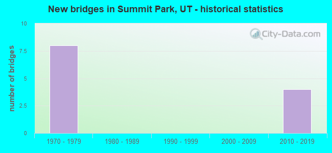
- New bridges - historical statistics
- 81970-1979
- 42010-2019
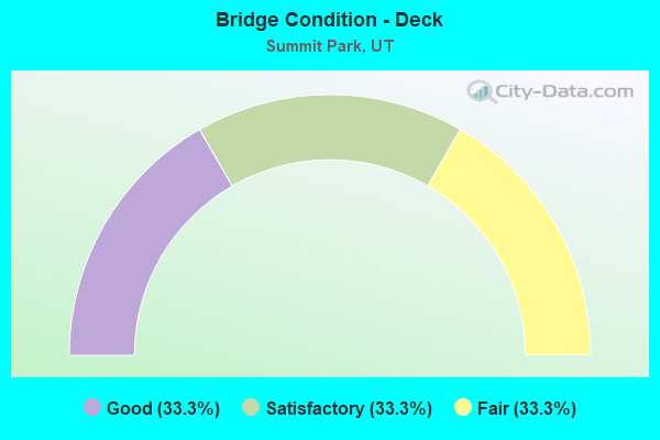
- Bridge Condition - Deck
- 33.3%Good
- 33.3%Satisfactory
- 33.3%Fair
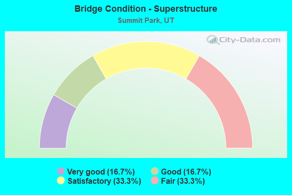
- Bridge Condition - Superstructure
- 16.7%Very good
- 16.7%Good
- 33.3%Satisfactory
- 33.3%Fair
Find on map >> Show street view
Structure Number: 2C1004, Location: At Parleys Summit Intchg (Lat: 40.752781, Lng: -111.614897), Route carried "on" structure: Interstate 80, Year Built: 2011, Status: Open, Structure Length: 4.04m (13.25ft), Average Daily Traffic: 55,066 (year 2020), Truck Traffic: 25%, Average Future Daily Traffic: 68,833 (year 2040), Design Load: HL 93, Features Intersected: INT.X-RD@PARLEYS SUMMIT
Minimum Vertical Clearance: 30+ m (98+ ft), Kilometerpoint: 224.772, Lanes on structure: 4, Lanes under structure: 3, Base Highway Network: Yes, Owner: State Highway Agency, Approaching Roadway Width: 22.3m (73.2ft), Skew: 10 degrees, Material/Design: Steel, Design/Construction: Stringer/Multi-beam, Number Of Spans In Main Unit: 1, Length of Maximum Span: 39.6m (129.9ft), Curb-To-Curb Width: 22.3m (73.2ft), Out-to-Out Width: 23.2m (76.1ft)
Condition: Deck: Good, Superstructure: Very good, Substructure: Satisfactory, Operating Rating: 58.3 metric tons, Method Used To Determine Operating Rating: Load and Resistance Factor Rating (LRFR) rating reported by rating factor(RF) method using HL-93 loadings, Inventory Rating: 45.0 metric tons, Method Used To Determine Inventory Rating: Load and Resistance Factor Rating (LRFR) rating reported by rating factor(RF) method using HL-93 loadings, Structural Evaluation: Equal to present minimum criteria, Deck Geometry: Superior to present desirable criteria, Underclear: Equal to present minimum criteria, Approach Roadway Alignment: Equal to present desirable criteria, Designated Inspection Frequency: Every 24 months, Inspection Date: August 2020, Deck Structure Type: Concrete Cast-file-Place, Wearing Surface/Protective System: Wearing Surface: Epoxy Overlay, Deck Protection: Epoxy Coated Reinforcing
Find on map >> Show street view
Structure Number: 2F 86, Location: JEREMY RANCH INTCHG. (Lat: 40.753956, Lng: -111.573011), Route carried "on" structure: Interstate 80, Year Built: 1971, Status: Open, Structure Length: 5.77m (18.93ft), Average Daily Traffic: 55,066 (year 2020), Truck Traffic: 25%, Average Future Daily Traffic: 68,833 (year 2040), Design Load: HS 20+Mod, Features Intersected: CO. RD. INTCHG. X-ROAD
Minimum Vertical Clearance: 30+ m (98+ ft), Kilometerpoint: 228.588, Lanes on structure: 3, Lanes under structure: 2, Base Highway Network: Yes, Owner: State Highway Agency, Approaching Roadway Width: 18.3m (60.0ft), Skew: 12 degrees, Material/Design: Prestressed concrete, Design/Construction: Stringer/Multi-beam, Number Of Spans In Main Unit: 3, Length of Maximum Span: 21.3m (69.9ft), Curb-To-Curb Width: 17.2m (56.4ft), Out-to-Out Width: 18.4m (60.4ft)
Condition: Deck: Fair, Superstructure: Fair, Substructure: Satisfactory, Operating Rating: 38.2 metric tons, Method Used To Determine Operating Rating: Load and Resistance Factor Rating (LRFR) rating reported by rating factor(RF) method using HL-93 loadings, Inventory Rating: 31.1 metric tons, Method Used To Determine Inventory Rating: Load Factor (LF) rating reported by rating factor (RF) method using MS18 loading, Structural Evaluation: Somewhat better than minimum adequacy, Deck Geometry: Better than present minimum criteria, Underclear: Better than present minimum criteria, Approach Roadway Alignment: Equal to present desirable criteria, Designated Inspection Frequency: Every 24 months, Inspection Date: August 2020, Deck Structure Type: Concrete Cast-file-Place, Wearing Surface/Protective System: Wearing Surface: Bituminous, Membrane: Preformed Fabric
Find on map >> Show street view
Structure Number: 2F 254R, Location: At Lambs Canyon Intchg. (Lat: 40.739278, Lng: -111.672886), Route carried "on" structure: Interstate 80, Year Built: 1972, Year Reconstructed: 2008, Status: Open, Structure Length: 2.68m (8.79ft), Average Daily Traffic: 51,742 (year 2020), Truck Traffic: 25%, Average Future Daily Traffic: 64,678 (year 2040), Design Load: HL 93, Features Intersected: LAMBS CYN.RD.,INT.X-ROAD
Minimum Vertical Clearance: 30+ m (98+ ft), Kilometerpoint: 219.483, Lanes on structure: 3, Lanes under structure: 2, Base Highway Network: Yes, Owner: State Highway Agency, Approaching Roadway Width: 15.9m (52.2ft), Skew: 10 degrees, Material/Design: Prestressed concrete, Design/Construction: Stringer/Multi-beam, Number Of Spans In Main Unit: 1, Length of Maximum Span: 25.6m (84.0ft), Curb-To-Curb Width: 16.4m (53.8ft), Out-to-Out Width: 17.3m (56.8ft)
Condition: Deck: Satisfactory, Superstructure: Satisfactory, Substructure: Satisfactory, Operating Rating: 39.5 metric tons, Method Used To Determine Operating Rating: Load and Resistance Factor Rating (LRFR) rating reported by rating factor(RF) method using HL-93 loadings, Inventory Rating: 39.2 metric tons, Method Used To Determine Inventory Rating: Load and Resistance Factor Rating (LRFR) rating reported by rating factor(RF) method using HL-93 loadings, Structural Evaluation: Equal to present minimum criteria, Deck Geometry: Equal to present minimum criteria, Underclear: Equal to present desirable criteria, Approach Roadway Alignment: Better than present minimum criteria, Designated Inspection Frequency: Every 24 months, Inspection Date: June 2020, Deck Structure Type: Concrete Cast-file-Place, Wearing Surface/Protective System: Wearing Surface: Epoxy Overlay, Deck Protection: Epoxy Coated Reinforcing
Find on map >> Show street view
Structure Number: 4C1004, Location: At Parleys Summit Intchg. (Lat: 40.752833, Lng: -111.614158), Route carried "on" structure: Interstate 80, Year Built: 2011, Status: Open, Structure Length: 4.04m (13.25ft), Average Daily Traffic: 51,639 (year 2020), Truck Traffic: 25%, Average Future Daily Traffic: 64,549 (year 2040), Design Load: HL 93, Features Intersected: INT.X-RD@PARLEYS SUMMIT
Minimum Vertical Clearance: 30+ m (98+ ft), Kilometerpoint: 224.700, Lanes on structure: 4, Lanes under structure: 3, Base Highway Network: Yes, Owner: State Highway Agency, Approaching Roadway Width: 22.3m (73.2ft), Skew: 10 degrees, Material/Design: Steel, Design/Construction: Stringer/Multi-beam, Number Of Spans In Main Unit: 1, Length of Maximum Span: 39.6m (129.9ft), Curb-To-Curb Width: 22.3m (73.2ft), Out-to-Out Width: 23.2m (76.1ft)
Condition: Deck: Good, Superstructure: Good, Substructure: Satisfactory, Operating Rating: 58.3 metric tons, Method Used To Determine Operating Rating: Load and Resistance Factor Rating (LRFR) rating reported by rating factor(RF) method using HL-93 loadings, Inventory Rating: 45.0 metric tons, Method Used To Determine Inventory Rating: Load and Resistance Factor Rating (LRFR) rating reported by rating factor(RF) method using HL-93 loadings, Structural Evaluation: Equal to present minimum criteria, Deck Geometry: Superior to present desirable criteria, Underclear: Superior to present desirable criteria, Approach Roadway Alignment: Equal to present desirable criteria, Designated Inspection Frequency: Every 24 months, Inspection Date: August 2020, Deck Structure Type: Concrete Cast-file-Place, Wearing Surface/Protective System: Wearing Surface: Epoxy Overlay, Deck Protection: Epoxy Coated Reinforcing
Find on map >> Show street view
Structure Number: 4F 86, Location: JEREMY RANCH INTCHG. (Lat: 40.753542, Lng: -111.571653), Route carried "on" structure: Interstate 80, Year Built: 1971, Status: Open, Structure Length: 5.77m (18.93ft), Average Daily Traffic: 55,066 (year 2020), Truck Traffic: 25%, Average Future Daily Traffic: 68,833 (year 2040), Design Load: HS 20+Mod, Features Intersected: CO.RD. INTCHG. X-ROAD
Minimum Vertical Clearance: 30+ m (98+ ft), Kilometerpoint: 228.585, Lanes on structure: 3, Lanes under structure: 2, Base Highway Network: Yes, Owner: State Highway Agency, Approaching Roadway Width: 17.2m (56.4ft), Skew: 12 degrees, Material/Design: Prestressed concrete, Design/Construction: Stringer/Multi-beam, Number Of Spans In Main Unit: 3, Length of Maximum Span: 21.3m (69.9ft), Curb-To-Curb Width: 17.2m (56.4ft), Out-to-Out Width: 18.4m (60.4ft)
Condition: Deck: Fair, Superstructure: Fair, Substructure: Satisfactory, Operating Rating: 38.2 metric tons, Method Used To Determine Operating Rating: Load and Resistance Factor Rating (LRFR) rating reported by rating factor(RF) method using HL-93 loadings, Inventory Rating: 31.1 metric tons, Method Used To Determine Inventory Rating: Load Factor (LF) rating reported by rating factor (RF) method using MS18 loading, Structural Evaluation: Somewhat better than minimum adequacy, Deck Geometry: Better than present minimum criteria, Underclear: Better than present minimum criteria, Approach Roadway Alignment: Equal to present desirable criteria, Designated Inspection Frequency: Every 24 months, Inspection Date: August 2020, Deck Structure Type: Concrete Cast-file-Place, Wearing Surface/Protective System: Wearing Surface: Bituminous, Membrane: Preformed Fabric
Find on map >> Show street view
Structure Number: 4F 254R, Location: At the Lambs Canyon Int. (Lat: 40.739347, Lng: -111.672342), Route carried "on" structure: Interstate 80, Year Built: 1972, Year Reconstructed: 2008, Status: Open, Structure Length: 2.56m (8.40ft), Average Daily Traffic: 51,742 (year 2020), Truck Traffic: 25%, Average Future Daily Traffic: 64,678 (year 2040), Design Load: HL 93, Features Intersected: LAMBS CYN.RD.,INT.X-ROAD
Minimum Vertical Clearance: 30+ m (98+ ft), Kilometerpoint: 219.387, Lanes on structure: 3, Lanes under structure: 2, Base Highway Network: Yes, Owner: State Highway Agency, Approaching Roadway Width: 15.9m (52.2ft), Skew: 10 degrees, Material/Design: Prestressed concrete, Design/Construction: Stringer/Multi-beam, Number Of Spans In Main Unit: 1, Length of Maximum Span: 25.6m (84.0ft), Curb-To-Curb Width: 16.4m (53.8ft), Out-to-Out Width: 17.3m (56.8ft)
Condition: Deck: Satisfactory, Superstructure: Satisfactory, Substructure: Satisfactory, Operating Rating: 41.8 metric tons, Method Used To Determine Operating Rating: Load and Resistance Factor Rating (LRFR) rating reported by rating factor(RF) method using HL-93 loadings, Inventory Rating: 39.2 metric tons, Method Used To Determine Inventory Rating: Load and Resistance Factor Rating (LRFR) rating reported by rating factor(RF) method using HL-93 loadings, Structural Evaluation: Equal to present minimum criteria, Deck Geometry: Equal to present minimum criteria, Underclear: High priority of corrective action, Approach Roadway Alignment: Better than present minimum criteria, Designated Inspection Frequency: Every 26 months, Inspection Date: June 2020, Deck Structure Type: Concrete Cast-file-Place, Wearing Surface/Protective System: Wearing Surface: Epoxy Overlay, Deck Protection: Epoxy Coated Reinforcing
Find on map >> Show street view
Structure Number: 2C1004, Location: At Parleys Summit Intchg (Lat: 40.752781, Lng: -111.614897), Route carried "under" structure: County highway , Year Built: 2011, Structure Length: 0. m, Features Intersected: INT.X-RD@PARLEYS SUMMIT, Facility Carried by Structure: I-80EB, (SR-80)
Minimum Vertical Clearance: 6.97m (22.87ft), Kilometerpoint: 0.000, Lanes on structure: 4, Lanes under structure: 3, Material/Design: Steel, Design/Construction: Stringer/Multi-beam, Length of Maximum Span: 39.6m (129.9ft)
Find on map >> Show street view
Structure Number: 2F 86, Location: JEREMY RANCH INTCHG. (Lat: 40.753956, Lng: -111.573011), Route carried "under" structure: County highway 2605, Year Built: 1971, Structure Length: 0. m, Average Daily Traffic: 939 (year 2020), Features Intersected: CO. RD. INTCHG. X-ROAD, Facility Carried by Structure: I-80 (SR-80) EBL
Minimum Vertical Clearance: 4.99m (16.37ft), Kilometerpoint: 0.000, Lanes on structure: 3, Lanes under structure: 2, Material/Design: Prestressed concrete, Design/Construction: Stringer/Multi-beam, Length of Maximum Span: 21.3m (69.9ft)
Find on map >> Show street view
Structure Number: 2F 254R, Location: At Lambs Canyon Intchg. (Lat: 40.739278, Lng: -111.672886), Route carried "under" structure: County highway , Year Built: 1972, Structure Length: 0. m, Features Intersected: LAMBS CYN.RD.,INT.X-ROAD, Facility Carried by Structure: I-80EB (SR-80)
Minimum Vertical Clearance: 5.12m (16.80ft), Kilometerpoint: 0.000, Lanes on structure: 3, Lanes under structure: 2, Material/Design: Prestressed concrete, Design/Construction: Stringer/Multi-beam, Length of Maximum Span: 25.6m (84.0ft)
Find on map >> Show street view
Structure Number: 4C1004, Location: At Parleys Summit Intchg. (Lat: 40.752833, Lng: -111.614158), Route carried "under" structure: County highway 2602, Year Built: 2011, Structure Length: 0. m, Average Daily Traffic: 1,137 (year 2020), Features Intersected: INT.X-RD@PARLEYS SUMMIT, Facility Carried by Structure: I-80WB, (SR-80)
Minimum Vertical Clearance: 5.22m (17.13ft), Kilometerpoint: 0.000, Lanes on structure: 4, Lanes under structure: 3, Material/Design: Steel, Design/Construction: Stringer/Multi-beam, Length of Maximum Span: 39.6m (129.9ft)
Find on map >> Show street view
Structure Number: 4F 86, Location: JEREMY RANCH INTCHG. (Lat: 40.753542, Lng: -111.571653), Route carried "under" structure: County highway 2605, Year Built: 1971, Structure Length: 0. m, Average Daily Traffic: 939 (year 2020), Features Intersected: CO.RD. INTCHG. X-ROAD, Facility Carried by Structure: I-80 (SR-80) WBL
Minimum Vertical Clearance: 6.97m (22.87ft), Kilometerpoint: 0.000, Lanes on structure: 3, Lanes under structure: 2, Material/Design: Prestressed concrete, Design/Construction: Stringer/Multi-beam, Length of Maximum Span: 21.3m (69.9ft)
Find on map >> Show street view
Structure Number: 4F 254R, Location: At the Lambs Canyon Int. (Lat: 40.739347, Lng: -111.672342), Route carried "under" structure: County highway , Year Built: 1972, Structure Length: 0. m, Features Intersected: LAMBS CYN.RD.,INT.X-ROAD, Facility Carried by Structure: I-80WB (SR-80)
Minimum Vertical Clearance: 5.04m (16.54ft), Kilometerpoint: 0.000, Lanes on structure: 3, Lanes under structure: 2, Material/Design: Prestressed concrete, Design/Construction: Stringer/Multi-beam, Length of Maximum Span: 25.6m (84.0ft)