Bridge Statistics for Sundance, Wyoming (WY)
Condition, Traffic, Stress, Structural Evaluation, Project Costs
- National Bridge Inventory (NBI) Statistics
- 37Number of bridges
- 285ft / 87.4mTotal length
- $647,000Total costs
- 86,191Total average daily traffic
- 20,417Total average daily truck traffic
- National Bridge Inventory (NBI) Registered Bridges for Sundance
- No street view available for this location
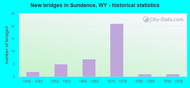
- New bridges - historical statistics
- 21940-1949
- 51950-1959
- 71960-1969
- 211970-1979
- 11980-1989
- 11990-1999
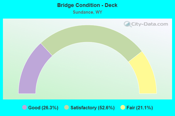
- Bridge Condition - Deck
- 26.3%Good
- 52.6%Satisfactory
- 21.1%Fair
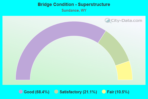
- Bridge Condition - Superstructure
- 68.4%Good
- 21.1%Satisfactory
- 10.5%Fair
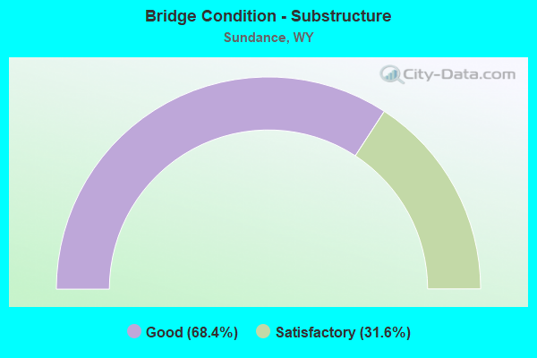
- Bridge Condition - Substructure
- 68.4%Good
- 31.6%Satisfactory
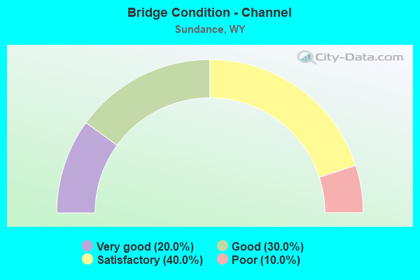
- Bridge Condition - Channel
- 20.0%Very good
- 30.0%Good
- 40.0%Satisfactory
- 10.0%Poor
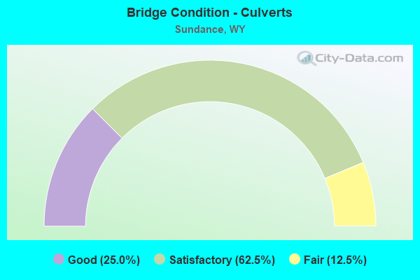
- Bridge Condition - Culverts
- 25.0%Good
- 62.5%Satisfactory
- 12.5%Fair
Find on map >> Show street view
Structure Number: BJA, Location: Moorcroft - Sundance (Lat: 44.370289, Lng: -104.444603), Route carried "on" structure: Interstate 90, Year Built: 1959, Status: Open, Structure Length: 3.26m (10.70ft), Average Daily Traffic: 3,054 (year 2021), Truck Traffic: 62%, Average Future Daily Traffic: 4,276 (year 2041), Design Load: HS 20+Mod, Features Intersected: CR 93 / Old Sundance Rd
Minimum Vertical Clearance: 30+ m (98+ ft), Kilometerpoint: 296.612, Lanes on structure: 2, Lanes under structure: 2, Base Highway Network: Yes (Inventory Route: ML9, Subroute: 3), Owner: State Highway Agency, Approaching Roadway Width: 10.4m (34.1ft), Skew: 10 degrees, Material/Design: Steel continuous, Design/Construction: Stringer/Multi-beam, Number Of Spans In Main Unit: 3, Length of Maximum Span: 12.2m (40.0ft), Curb-To-Curb Width: 11.6m (38.1ft), Out-to-Out Width: 12.6m (41.3ft)
Condition: Deck: Satisfactory, Superstructure: Satisfactory, Substructure: Good, Operating Rating: 67.1 metric tons, Method Used To Determine Operating Rating: Load Factor (LF), Inventory Rating: 39.9 metric tons, Method Used To Determine Inventory Rating: Load Factor (LF), Structural Evaluation: Equal to present minimum criteria, Deck Geometry: Equal to present minimum criteria, Underclear: Meets minimum limits, Approach Roadway Alignment: Equal to present desirable criteria, Designated Inspection Frequency: Every 24 months, Inspection Date: June 2021, Deck Structure Type: Concrete Cast-file-Place, Wearing Surface/Protective System: Wearing Surface: Latex Concrete
Find on map >> Show street view
Structure Number: BJB, Location: Moorcroft - Sundance (Lat: 44.370444, Lng: -104.444775), Route carried "on" structure: Interstate 90, Year Built: 1959, Status: Open, Structure Length: 3.26m (10.70ft), Average Daily Traffic: 3,024 (year 2021), Truck Traffic: 17%, Average Future Daily Traffic: 4,234 (year 2041), Design Load: HS 20+Mod, Features Intersected: CR 93 / Old Sundance Rd
Minimum Vertical Clearance: 30+ m (98+ ft), Kilometerpoint: 296.393, Lanes on structure: 2, Lanes under structure: 2, Base Highway Network: Yes (Inventory Route: ML9, Subroute: 3), Owner: State Highway Agency, Approaching Roadway Width: 10.4m (34.1ft), Skew: 10 degrees, Material/Design: Steel continuous, Design/Construction: Stringer/Multi-beam, Number Of Spans In Main Unit: 3, Length of Maximum Span: 12.2m (40.0ft), Curb-To-Curb Width: 11.9m (39.0ft), Out-to-Out Width: 12.5m (41.0ft)
Condition: Deck: Satisfactory, Superstructure: Good, Substructure: Good, Operating Rating: 67.1 metric tons, Method Used To Determine Operating Rating: Load Factor (LF), Inventory Rating: 39.9 metric tons, Method Used To Determine Inventory Rating: Load Factor (LF), Structural Evaluation: Better than present minimum criteria, Deck Geometry: Equal to present minimum criteria, Underclear: Meets minimum limits, Approach Roadway Alignment: Equal to present desirable criteria, Designated Inspection Frequency: Every 24 months, Inspection Date: June 2021, Deck Structure Type: Concrete Cast-file-Place, Wearing Surface/Protective System: Wearing Surface: Latex Concrete
Find on map >> Show street view
Structure Number: BJC, Location: Moorcroft - Sundance (Lat: 44.389311, Lng: -104.399122), Route carried "on" structure: Interstate 90, Year Built: 1965, Status: Open, Structure Length: 0.95m (3.12ft), Average Daily Traffic: 3,054 (year 2021), Truck Traffic: 53%, Average Future Daily Traffic: 4,276 (year 2041), Design Load: HS 20+Mod, Features Intersected: Unnamed Draw
Minimum Vertical Clearance: 30+ m (98+ ft), Kilometerpoint: 301.195, Lanes on structure: 6, Base Highway Network: Yes (Inventory Route: ML9, Subroute: 3), Owner: State Highway Agency, Approaching Roadway Width: 31.1m (102.0ft), Material/Design: Concrete continuous, Design/Construction: Culvert, Number Of Spans In Main Unit: 3, Length of Maximum Span: 3.5m (11.5ft)
Condition: Channel: Good, Culverts: Fair, Operating Rating: 32.7 metric tons, Method Used To Determine Operating Rating: Field evaluation and documented engineering judgment, Inventory Rating: 32.7 metric tons, Method Used To Determine Inventory Rating: Field evaluation and documented engineering judgment, Structural Evaluation: Somewhat better than minimum adequacy, Waterway Adequacy: Equal to present desirable criteria, Approach Roadway Alignment: Equal to present desirable criteria, Designated Inspection Frequency: Every 24 months, Inspection Date: June 2021
Find on map >> Show street view
Structure Number: BJD, Location: Sundance (Lat: 44.391903, Lng: -104.398033), Route carried "on" structure: Interstate 90, Year Built: 1969, Status: Open, Structure Length: 5.18m (16.99ft), Average Daily Traffic: 3,054 (year 2021), Truck Traffic: 53%, Average Future Daily Traffic: 4,276 (year 2041), Design Load: HS 20+Mod, Features Intersected: US 14
Minimum Vertical Clearance: 30+ m (98+ ft), Kilometerpoint: 301.495, Lanes on structure: 2, Lanes under structure: 2, Base Highway Network: Yes (Inventory Route: ML9, Subroute: 4), Owner: State Highway Agency, Approaching Roadway Width: 10.4m (34.1ft), Skew: 12 degrees, Material/Design: Concrete continuous, Design/Construction: Box Beam or Girders - Multiple, Number Of Spans In Main Unit: 3, Length of Maximum Span: 22.9m (75.1ft), Curb-To-Curb Width: 12.8m (42.0ft), Out-to-Out Width: 13.6m (44.6ft)
Condition: Deck: Satisfactory, Superstructure: Fair, Substructure: Good, Operating Rating: 71.7 metric tons, Method Used To Determine Operating Rating: Load Factor (LF), Inventory Rating: 42.6 metric tons, Method Used To Determine Inventory Rating: Load Factor (LF), Structural Evaluation: Somewhat better than minimum adequacy, Deck Geometry: Equal to present desirable criteria, Underclear: Superior to present desirable criteria, Approach Roadway Alignment: Equal to present desirable criteria, Length Of Structure Improvement: 0.30m (0.98ft), Designated Inspection Frequency: Every 24 months, Inspection Date: June 2021, Bridge Improvement Cost: $10,000, Roadway Improvement Cost: $1,000, Total Project Cost: $12,000 ( Estimate for 2014), Deck Structure Type: Concrete Cast-file-Place, Wearing Surface/Protective System: Wearing Surface: Latex Concrete
Find on map >> Show street view
Structure Number: BJE, Location: Sundance (Lat: 44.391908, Lng: -104.398314), Route carried "on" structure: Interstate 90, Year Built: 1969, Status: Open, Structure Length: 5.18m (16.99ft), Average Daily Traffic: 3,024 (year 2021), Truck Traffic: 17%, Average Future Daily Traffic: 4,234 (year 2041), Design Load: HS 20+Mod, Features Intersected: US 14
Minimum Vertical Clearance: 30+ m (98+ ft), Kilometerpoint: 301.256, Lanes on structure: 2, Lanes under structure: 2, Base Highway Network: Yes (Inventory Route: ML9, Subroute: 4), Owner: State Highway Agency, Approaching Roadway Width: 10.4m (34.1ft), Skew: 12 degrees, Material/Design: Concrete continuous, Design/Construction: Box Beam or Girders - Multiple, Number Of Spans In Main Unit: 3, Length of Maximum Span: 22.9m (75.1ft), Curb-To-Curb Width: 12.8m (42.0ft), Out-to-Out Width: 13.6m (44.6ft)
Condition: Deck: Satisfactory, Superstructure: Fair, Substructure: Satisfactory, Operating Rating: 71.7 metric tons, Method Used To Determine Operating Rating: Load Factor (LF), Inventory Rating: 42.6 metric tons, Method Used To Determine Inventory Rating: Load Factor (LF), Structural Evaluation: Somewhat better than minimum adequacy, Deck Geometry: Equal to present desirable criteria, Underclear: Superior to present desirable criteria, Approach Roadway Alignment: Equal to present desirable criteria, Length Of Structure Improvement: 0.30m (0.98ft), Designated Inspection Frequency: Every 24 months, Inspection Date: June 2021, Bridge Improvement Cost: $10,000, Roadway Improvement Cost: $1,000, Total Project Cost: $12,000 ( Estimate for 2014), Deck Structure Type: Concrete Cast-file-Place, Wearing Surface/Protective System: Wearing Surface: Latex Concrete
Find on map >> Show street view
Structure Number: BJF, Location: Sundance (Lat: 44.397203, Lng: -104.384111), Route carried "on" structure: Interstate 90, Year Built: 1971, Status: Open, Structure Length: 7.01m (23.00ft), Average Daily Traffic: 2,978 (year 2021), Truck Traffic: 38%, Average Future Daily Traffic: 4,169 (year 2041), Design Load: HS 20+Mod, Features Intersected: US 14
Minimum Vertical Clearance: 30+ m (98+ ft), Kilometerpoint: 302.869, Lanes on structure: 2, Lanes under structure: 3, Base Highway Network: Yes (Inventory Route: ML9, Subroute: 4), Owner: State Highway Agency, Approaching Roadway Width: 11.0m (36.1ft), Skew: 14 degrees, Material/Design: Steel continuous, Design/Construction: Stringer/Multi-beam, Number Of Spans In Main Unit: 3, Length of Maximum Span: 26.8m (87.9ft), Curb-To-Curb Width: 12.8m (42.0ft), Out-to-Out Width: 13.6m (44.6ft)
Condition: Deck: Satisfactory, Superstructure: Satisfactory, Substructure: Satisfactory, Operating Rating: 50.8 metric tons, Method Used To Determine Operating Rating: Load Factor (LF), Inventory Rating: 29.9 metric tons, Method Used To Determine Inventory Rating: Load Factor (LF), Structural Evaluation: Equal to present minimum criteria, Deck Geometry: Equal to present desirable criteria, Underclear: Meets minimum limits, Approach Roadway Alignment: Equal to present desirable criteria, Length Of Structure Improvement: 16.37m (53.71ft), Designated Inspection Frequency: Every 24 months, Inspection Date: June 2021, Deck Structure Type: Concrete Cast-file-Place, Wearing Surface/Protective System: Wearing Surface: Latex Concrete
Find on map >> Show street view
Structure Number: BJG, Location: Sundance (Lat: 44.397378, Lng: -104.383842), Route carried "on" structure: Interstate 90, Year Built: 1972, Status: Open, Structure Length: 7.01m (23.00ft), Average Daily Traffic: 3,024 (year 2021), Truck Traffic: 17%, Average Future Daily Traffic: 4,234 (year 2041), Design Load: HS 20+Mod, Features Intersected: US 14
Minimum Vertical Clearance: 30+ m (98+ ft), Kilometerpoint: 302.689, Lanes on structure: 2, Lanes under structure: 2, Base Highway Network: Yes (Inventory Route: ML9, Subroute: 4), Owner: State Highway Agency, Approaching Roadway Width: 11.6m (38.1ft), Skew: 14 degrees, Material/Design: Steel continuous, Design/Construction: Stringer/Multi-beam, Number Of Spans In Main Unit: 3, Length of Maximum Span: 26.8m (87.9ft), Curb-To-Curb Width: 12.8m (42.0ft), Out-to-Out Width: 13.6m (44.6ft)
Condition: Deck: Fair, Superstructure: Satisfactory, Substructure: Satisfactory, Operating Rating: 50.8 metric tons, Method Used To Determine Operating Rating: Load Factor (LF), Inventory Rating: 29.9 metric tons, Method Used To Determine Inventory Rating: Load Factor (LF), Structural Evaluation: Equal to present minimum criteria, Deck Geometry: Equal to present desirable criteria, Underclear: Equal to present minimum criteria, Approach Roadway Alignment: Equal to present desirable criteria, Designated Inspection Frequency: Every 24 months, Inspection Date: June 2021, Deck Structure Type: Concrete Cast-file-Place, Wearing Surface/Protective System: Wearing Surface: Latex Concrete
Find on map >> Show street view
Structure Number: BJH, Location: Sundance (Lat: 44.401478, Lng: -104.366333), Route carried "on" structure: Interstate 90, Year Built: 1972, Status: Open, Structure Length: 6.55m (21.49ft), Average Daily Traffic: 2,978 (year 2021), Truck Traffic: 42%, Average Future Daily Traffic: 4,169 (year 2041), Design Load: HS 20+Mod, Features Intersected: WYO 585
Minimum Vertical Clearance: 30+ m (98+ ft), Kilometerpoint: 304.386, Lanes on structure: 2, Lanes under structure: 2, Base Highway Network: Yes (Inventory Route: ML9, Subroute: 4), Owner: State Highway Agency, Approaching Roadway Width: 11.0m (36.1ft), Skew: 14 degrees, Material/Design: Steel continuous, Design/Construction: Stringer/Multi-beam, Number Of Spans In Main Unit: 3, Length of Maximum Span: 25.3m (83.0ft), Curb-To-Curb Width: 12.8m (42.0ft), Out-to-Out Width: 13.6m (44.6ft)
Condition: Deck: Fair, Superstructure: Good, Substructure: Good, Operating Rating: 52.6 metric tons, Method Used To Determine Operating Rating: Load Factor (LF), Inventory Rating: 31.8 metric tons, Method Used To Determine Inventory Rating: Load Factor (LF), Structural Evaluation: Better than present minimum criteria, Deck Geometry: Equal to present desirable criteria, Underclear: Meets minimum limits, Approach Roadway Alignment: Equal to present desirable criteria, Length Of Structure Improvement: 3.35m (10.99ft), Designated Inspection Frequency: Every 24 months, Inspection Date: June 2021, Deck Structure Type: Concrete Cast-file-Place
Find on map >> Show street view
Structure Number: BJI, Location: Sundance (Lat: 44.401597, Lng: -104.366714), Route carried "on" structure: Interstate 90, Year Built: 1972, Status: Open, Structure Length: 6.55m (21.49ft), Average Daily Traffic: 3,024 (year 2021), Truck Traffic: 17%, Average Future Daily Traffic: 4,234 (year 2041), Design Load: HS 20+Mod, Features Intersected: WYO 585
Minimum Vertical Clearance: 30+ m (98+ ft), Kilometerpoint: 304.150, Lanes on structure: 2, Lanes under structure: 2, Base Highway Network: Yes (Inventory Route: ML9, Subroute: 4), Owner: State Highway Agency, Approaching Roadway Width: 11.6m (38.1ft), Skew: 14 degrees, Material/Design: Steel continuous, Design/Construction: Stringer/Multi-beam, Number Of Spans In Main Unit: 3, Length of Maximum Span: 25.3m (83.0ft), Curb-To-Curb Width: 12.8m (42.0ft), Out-to-Out Width: 13.6m (44.6ft)
Condition: Deck: Satisfactory, Superstructure: Good, Substructure: Satisfactory, Operating Rating: 52.6 metric tons, Method Used To Determine Operating Rating: Load Factor (LF), Inventory Rating: 31.8 metric tons, Method Used To Determine Inventory Rating: Load Factor (LF), Structural Evaluation: Equal to present minimum criteria, Deck Geometry: Equal to present desirable criteria, Underclear: Meets minimum limits, Approach Roadway Alignment: Equal to present desirable criteria, Designated Inspection Frequency: Every 24 months, Inspection Date: June 2021, Deck Structure Type: Concrete Cast-file-Place, Wearing Surface/Protective System: Wearing Surface: Epoxy Overlay
Find on map >> Show street view
Structure Number: BJJ, Location: Sundance (Lat: 44.405908, Lng: -104.356597), Route carried "on" structure: Interstate 90, Year Built: 1972, Status: Open, Structure Length: 2.32m (7.61ft), Average Daily Traffic: 2,978 (year 2021), Truck Traffic: 42%, Average Future Daily Traffic: 4,169 (year 2041), Design Load: HS 20+Mod, Features Intersected: Machinery Pass
Minimum Vertical Clearance: 30+ m (98+ ft), Kilometerpoint: 305.310, Lanes on structure: 2, Base Highway Network: Yes (Inventory Route: ML9, Subroute: 4), Owner: State Highway Agency, Approaching Roadway Width: 11.6m (38.1ft), Skew: 10 degrees, Material/Design: Concrete continuous, Design/Construction: Stringer/Multi-beam, Number Of Spans In Main Unit: 3, Length of Maximum Span: 9.4m (30.8ft), Curb-To-Curb Width: 12.8m (42.0ft), Out-to-Out Width: 13.6m (44.6ft)
Condition: Deck: Satisfactory, Superstructure: Good, Substructure: Good, Operating Rating: 47.0 metric tons, Method Used To Determine Operating Rating: Load Factor (LF), Inventory Rating: 28.1 metric tons, Method Used To Determine Inventory Rating: Load Factor (LF), Structural Evaluation: Better than present minimum criteria, Deck Geometry: Equal to present desirable criteria, Approach Roadway Alignment: Equal to present desirable criteria, Designated Inspection Frequency: Every 24 months, Inspection Date: June 2021, Deck Structure Type: Concrete Cast-file-Place
Find on map >> Show street view
Structure Number: BJK, Location: Sundance (Lat: 44.406064, Lng: -104.356858), Route carried "on" structure: Interstate 90, Year Built: 1972, Status: Open, Structure Length: 2.32m (7.61ft), Average Daily Traffic: 3,024 (year 2021), Truck Traffic: 17%, Average Future Daily Traffic: 4,234 (year 2041), Design Load: HS 20+Mod, Features Intersected: Machinery Pass
Minimum Vertical Clearance: 30+ m (98+ ft), Kilometerpoint: 305.083, Lanes on structure: 2, Base Highway Network: Yes (Inventory Route: ML9, Subroute: 4), Owner: State Highway Agency, Approaching Roadway Width: 11.0m (36.1ft), Skew: 10 degrees, Material/Design: Concrete continuous, Design/Construction: Stringer/Multi-beam, Number Of Spans In Main Unit: 3, Length of Maximum Span: 9.4m (30.8ft), Curb-To-Curb Width: 12.8m (42.0ft), Out-to-Out Width: 13.6m (44.6ft)
Condition: Deck: Satisfactory, Superstructure: Good, Substructure: Good, Operating Rating: 47.0 metric tons, Method Used To Determine Operating Rating: Load Factor (LF), Inventory Rating: 28.1 metric tons, Method Used To Determine Inventory Rating: Load Factor (LF), Structural Evaluation: Better than present minimum criteria, Deck Geometry: Equal to present desirable criteria, Approach Roadway Alignment: Equal to present desirable criteria, Designated Inspection Frequency: Every 24 months, Inspection Date: June 2021, Deck Structure Type: Concrete Cast-file-Place
Find on map >> Show street view
Structure Number: BJL, Location: Sundance (Lat: 44.414514, Lng: -104.343383), Route carried "on" structure: Interstate 90, Year Built: 1972, Status: Open, Structure Length: 4.75m (15.58ft), Average Daily Traffic: 2,978 (year 2021), Truck Traffic: 42%, Average Future Daily Traffic: 4,169 (year 2041), Design Load: HS 20+Mod, Features Intersected: I-90 Bus. / US 14
Minimum Vertical Clearance: 30+ m (98+ ft), Kilometerpoint: 306.743, Lanes on structure: 2, Lanes under structure: 2, Base Highway Network: Yes (Inventory Route: ML9, Subroute: 4), Owner: State Highway Agency, Approaching Roadway Width: 11.6m (38.1ft), Skew: 10 degrees, Material/Design: Concrete continuous, Design/Construction: Stringer/Multi-beam, Number Of Spans In Main Unit: 3, Length of Maximum Span: 18.3m (60.0ft), Curb-To-Curb Width: 12.8m (42.0ft), Out-to-Out Width: 13.6m (44.6ft)
Condition: Deck: Fair, Superstructure: Good, Substructure: Good, Operating Rating: 53.5 metric tons, Method Used To Determine Operating Rating: Load Factor (LF), Inventory Rating: 31.8 metric tons, Method Used To Determine Inventory Rating: Load Factor (LF), Structural Evaluation: Better than present minimum criteria, Deck Geometry: Equal to present desirable criteria, Underclear: Better than present minimum criteria, Approach Roadway Alignment: Equal to present desirable criteria, Designated Inspection Frequency: Every 24 months, Inspection Date: June 2021, Deck Structure Type: Concrete Cast-file-Place
Find on map >> Show street view
Structure Number: BJM, Location: Sundance (Lat: 44.414714, Lng: -104.343581), Route carried "on" structure: Interstate 90, Year Built: 1972, Status: Open, Structure Length: 4.75m (15.58ft), Average Daily Traffic: 3,024 (year 2021), Truck Traffic: 17%, Average Future Daily Traffic: 4,234 (year 2041), Design Load: HS 20+Mod, Features Intersected: I-90 Bus. / US 14
Minimum Vertical Clearance: 30+ m (98+ ft), Kilometerpoint: 306.524, Lanes on structure: 2, Lanes under structure: 2, Base Highway Network: Yes (Inventory Route: ML9, Subroute: 4), Owner: State Highway Agency, Approaching Roadway Width: 12.2m (40.0ft), Skew: 10 degrees, Material/Design: Concrete continuous, Design/Construction: Stringer/Multi-beam, Number Of Spans In Main Unit: 3, Length of Maximum Span: 18.3m (60.0ft), Curb-To-Curb Width: 12.8m (42.0ft), Out-to-Out Width: 13.6m (44.6ft)
Condition: Deck: Good, Superstructure: Satisfactory, Substructure: Good, Operating Rating: 53.5 metric tons, Method Used To Determine Operating Rating: Load Factor (LF), Inventory Rating: 31.8 metric tons, Method Used To Determine Inventory Rating: Load Factor (LF), Structural Evaluation: Equal to present minimum criteria, Deck Geometry: Equal to present desirable criteria, Underclear: Better than present minimum criteria, Approach Roadway Alignment: Equal to present desirable criteria, Designated Inspection Frequency: Every 24 months, Inspection Date: June 2021, Deck Structure Type: Concrete Cast-file-Place, Wearing Surface/Protective System: Wearing Surface: Epoxy Overlay
Find on map >> Show street view
Structure Number: BJN, Location: Sundance - S Dakota Line (Lat: 44.434550, Lng: -104.305989), Route carried "on" structure: ServiceOther road 146, Year Built: 1954, Status: Open, Structure Length: 2.47m (8.10ft), Average Daily Traffic: 455 (year 2021), Truck Traffic: 8%, Average Future Daily Traffic: 637 (year 2041), Design Load: HS 20, Features Intersected: Sundance Creek, Facility Carried by Structure: I-90 Service Road
Minimum Vertical Clearance: 30+ m (98+ ft), Kilometerpoint: 25.756, Lanes on structure: 2, Owner: State Highway Agency, Approaching Roadway Width: 9.8m (32.2ft), Material/Design: Concrete continuous, Design/Construction: Slab, Number Of Spans In Main Unit: 4, Length of Maximum Span: 6.6m (21.7ft), Curb-To-Curb Width: 9.8m (32.2ft), Out-to-Out Width: 10.7m (35.1ft)
Condition: Deck: Good, Superstructure: Good, Substructure: Good, Channel: Good, Operating Rating: 37.2 metric tons, Method Used To Determine Operating Rating: Load Factor (LF), Inventory Rating: 22.2 metric tons, Method Used To Determine Inventory Rating: Load Factor (LF), Structural Evaluation: Equal to present minimum criteria, Deck Geometry: Equal to present minimum criteria, Waterway Adequacy: Equal to present desirable criteria, Approach Roadway Alignment: Equal to present desirable criteria, Length Of Structure Improvement: 2.47m (8.10ft), Designated Inspection Frequency: Every 24 months, Inspection Date: August 2020, Bridge Improvement Cost: $29,000, Roadway Improvement Cost: $3,000, Total Project Cost: $44,000, Deck Structure Type: Concrete Cast-file-Place, Wearing Surface/Protective System: Wearing Surface: Bituminous
Find on map >> Show street view
Structure Number: BKI, Location: Sundance (Lat: 44.393525, Lng: -104.392047), Route carried "on" structure: Business US 90, Year Built: 1954, Status: Open, Structure Length: 0.75m (2.46ft), Average Daily Traffic: 1,841 (year 2021), Truck Traffic: 7%, Average Future Daily Traffic: 2,577 (year 2041), Design Load: HS 20, Features Intersected: S Fork Sundance Creek, Facility Carried by Structure: US 14
Minimum Vertical Clearance: 30+ m (98+ ft), Kilometerpoint: 321.592, Lanes on structure: 3, Owner: State Highway Agency, Approaching Roadway Width: 12.3m (40.4ft), Material/Design: Concrete continuous, Design/Construction: Culvert, Number Of Spans In Main Unit: 2, Length of Maximum Span: 3.7m (12.1ft)
Condition: Channel: Very good, Culverts: Good, Operating Rating: 32.7 metric tons, Method Used To Determine Operating Rating: Field evaluation and documented engineering judgment, Inventory Rating: 32.7 metric tons, Method Used To Determine Inventory Rating: Field evaluation and documented engineering judgment, Structural Evaluation: Better than present minimum criteria, Waterway Adequacy: Equal to present desirable criteria, Approach Roadway Alignment: Equal to present desirable criteria, Designated Inspection Frequency: Every 24 months, Inspection Date: August 2020
Find on map >> Show street view
Structure Number: CNG, Location: Sundance - Upton (Lat: 44.391000, Lng: -104.394469), Route carried "on" structure: State highway 116, Year Built: 1948, Status: Open, Structure Length: 0.96m (3.15ft), Average Daily Traffic: 565 (year 2021), Truck Traffic: 25%, Average Future Daily Traffic: 791 (year 2041), Design Load: H 15, Features Intersected: Sundance Creek
Minimum Vertical Clearance: 30+ m (98+ ft), Kilometerpoint: 0.195, Lanes on structure: 2, Owner: State Highway Agency, Approaching Roadway Width: 9.8m (32.2ft), Material/Design: Concrete continuous, Design/Construction: Culvert, Number Of Spans In Main Unit: 3, Length of Maximum Span: 3.0m (9.8ft)
Condition: Channel: Satisfactory, Culverts: Satisfactory, Operating Rating: 32.7 metric tons, Method Used To Determine Operating Rating: Field evaluation and documented engineering judgment, Inventory Rating: 32.7 metric tons, Method Used To Determine Inventory Rating: Field evaluation and documented engineering judgment, Structural Evaluation: Equal to present minimum criteria, Waterway Adequacy: Better than present minimum criteria, Approach Roadway Alignment: Equal to present desirable criteria, Designated Inspection Frequency: Every 24 months, Inspection Date: August 2020
Find on map >> Show street view
Structure Number: CNH, Location: Sundance - Upton (Lat: 44.345311, Lng: -104.388242), Route carried "on" structure: State highway 116, Year Built: 1948, Status: Open, Structure Length: 0.78m (2.56ft), Average Daily Traffic: 565 (year 2021), Truck Traffic: 25%, Average Future Daily Traffic: 791 (year 2041), Design Load: H 15, Features Intersected: N Fork Sundance Creek
Minimum Vertical Clearance: 30+ m (98+ ft), Kilometerpoint: 5.358, Lanes on structure: 2, Owner: State Highway Agency, Approaching Roadway Width: 7.9m (25.9ft), Material/Design: Steel, Design/Construction: Culvert, Number Of Spans In Main Unit: 3, Length of Maximum Span: 2.1m (6.9ft)
Condition: Channel: Satisfactory, Culverts: Satisfactory, Operating Rating: 32.7 metric tons, Method Used To Determine Operating Rating: Field evaluation and documented engineering judgment, Inventory Rating: 32.7 metric tons, Method Used To Determine Inventory Rating: Field evaluation and documented engineering judgment, Structural Evaluation: Equal to present minimum criteria, Waterway Adequacy: Equal to present desirable criteria, Approach Roadway Alignment: Equal to present desirable criteria, Designated Inspection Frequency: Every 24 months, Inspection Date: August 2020
Find on map >> Show street view
Structure Number: CYA, Location: Sundance - Jct I-90 (Lat: 44.401111, Lng: -104.381944), Route carried "on" structure: Business US 90, Year Built: 1954, Status: Open, Structure Length: 1.81m (5.94ft), Average Daily Traffic: 2,669 (year 2021), Truck Traffic: 7%, Average Future Daily Traffic: 3,737 (year 2041), Design Load: HS 20, Features Intersected: S Fork Sundance Creek, Facility Carried by Structure: US 14
Minimum Vertical Clearance: 30+ m (98+ ft), Kilometerpoint: 322.851, Lanes on structure: 4, Owner: State Highway Agency, Approaching Roadway Width: 21.9m (71.9ft), Skew: 24 degrees, Material/Design: Concrete continuous, Design/Construction: Culvert, Number Of Spans In Main Unit: 4, Length of Maximum Span: 3.0m (9.8ft), Curb or Sidewalk Widths: Left: 1.7m (5.6ft), Right: 1.7m (5.6ft), Curb-To-Curb Width: 15.1m (49.5ft), Out-to-Out Width: 25.5m (83.7ft)
Condition: Channel: Satisfactory, Culverts: Satisfactory, Operating Rating: 32.7 metric tons, Method Used To Determine Operating Rating: Field evaluation and documented engineering judgment, Inventory Rating: 19.6 metric tons, Method Used To Determine Inventory Rating: Field evaluation and documented engineering judgment, Structural Evaluation: Somewhat better than minimum adequacy, Deck Geometry: High priority of corrective action, Waterway Adequacy: Equal to present desirable criteria, Approach Roadway Alignment: Equal to present desirable criteria, Length Of Structure Improvement: 2.56m (8.40ft), Designated Inspection Frequency: Every 24 months, Inspection Date: August 2020, Bridge Improvement Cost: $386,000, Roadway Improvement Cost: $39,000, Total Project Cost: $579,000 ( Estimate for 2015), Deck Structure Type: Concrete Cast-file-Place, Wearing Surface/Protective System: Wearing Surface: Bituminous
Find on map >> Show street view
Structure Number: DAM, Location: Sundance - S Dakota Line (Lat: 44.426647, Lng: -104.319706), Route carried "on" structure: Interstate 90, Year Built: 1976, Status: Open, Structure Length: 2.29m (7.51ft), Average Daily Traffic: 2,978 (year 2021), Truck Traffic: 40%, Average Future Daily Traffic: 4,169 (year 2041), Design Load: HS 20+Mod, Features Intersected: Machinery Pass
Minimum Vertical Clearance: 30+ m (98+ ft), Kilometerpoint: 309.062, Lanes on structure: 2, Base Highway Network: Yes (Inventory Route: ML9, Subroute: 4), Owner: State Highway Agency, Approaching Roadway Width: 11.6m (38.1ft), Skew: 10 degrees, Material/Design: Concrete continuous, Design/Construction: Stringer/Multi-beam, Number Of Spans In Main Unit: 3, Length of Maximum Span: 9.4m (30.8ft), Curb-To-Curb Width: 12.8m (42.0ft), Out-to-Out Width: 13.6m (44.6ft)
Condition: Deck: Good, Superstructure: Good, Substructure: Satisfactory, Operating Rating: 49.9 metric tons, Method Used To Determine Operating Rating: Load Factor (LF), Inventory Rating: 29.9 metric tons, Method Used To Determine Inventory Rating: Load Factor (LF), Structural Evaluation: Equal to present minimum criteria, Deck Geometry: Equal to present desirable criteria, Approach Roadway Alignment: Equal to present desirable criteria, Designated Inspection Frequency: Every 24 months, Inspection Date: June 2021, Deck Structure Type: Concrete Cast-file-Place, Wearing Surface/Protective System: Wearing Surface: Epoxy Overlay
Find on map >> Show street view
Structure Number: DAN, Location: Sundance - S Dakota Line (Lat: 44.426836, Lng: -104.319897), Route carried "on" structure: Interstate 90, Year Built: 1976, Status: Open, Structure Length: 2.29m (7.51ft), Average Daily Traffic: 3,024 (year 2021), Truck Traffic: 17%, Average Future Daily Traffic: 4,234 (year 2041), Design Load: HS 20+Mod, Features Intersected: Machinery Pass
Minimum Vertical Clearance: 30+ m (98+ ft), Kilometerpoint: 308.841, Lanes on structure: 2, Base Highway Network: Yes (Inventory Route: ML9, Subroute: 4), Owner: State Highway Agency, Approaching Roadway Width: 11.6m (38.1ft), Skew: 10 degrees, Material/Design: Concrete continuous, Design/Construction: Stringer/Multi-beam, Number Of Spans In Main Unit: 3, Length of Maximum Span: 9.4m (30.8ft), Curb-To-Curb Width: 12.8m (42.0ft), Out-to-Out Width: 13.6m (44.6ft)
Condition: Deck: Satisfactory, Superstructure: Good, Substructure: Satisfactory, Operating Rating: 49.9 metric tons, Method Used To Determine Operating Rating: Load Factor (LF), Inventory Rating: 29.9 metric tons, Method Used To Determine Inventory Rating: Load Factor (LF), Structural Evaluation: Equal to present minimum criteria, Deck Geometry: Equal to present desirable criteria, Approach Roadway Alignment: Equal to present desirable criteria, Designated Inspection Frequency: Every 24 months, Inspection Date: June 2021, Deck Structure Type: Concrete Cast-file-Place, Wearing Surface/Protective System: Wearing Surface: Epoxy Overlay
Find on map >> Show street view
Structure Number: DAO, Location: Sundance - S Dakota Line (Lat: 44.427406, Lng: -104.319989), Route carried "on" structure: ServiceOther road , Year Built: 1976, Status: Open, Structure Length: 2.29m (7.51ft), Average Daily Traffic: 455 (year 2021), Truck Traffic: 8%, Average Future Daily Traffic: 637 (year 2041), Design Load: HS 20, Features Intersected: Machinery Pass, Facility Carried by Structure: I-90 Service Road
Minimum Vertical Clearance: 30+ m (98+ ft), Kilometerpoint: 27.124, Lanes on structure: 2, Owner: State Highway Agency, Approaching Roadway Width: 9.8m (32.2ft), Material/Design: Concrete continuous, Design/Construction: Stringer/Multi-beam, Number Of Spans In Main Unit: 3, Length of Maximum Span: 9.4m (30.8ft), Curb-To-Curb Width: 9.8m (32.2ft), Out-to-Out Width: 10.6m (34.8ft)
Condition: Deck: Good, Superstructure: Good, Substructure: Good, Operating Rating: 44.5 metric tons, Method Used To Determine Operating Rating: Load Factor (LF), Inventory Rating: 26.5 metric tons, Method Used To Determine Inventory Rating: Load Factor (LF), Structural Evaluation: Equal to present minimum criteria, Deck Geometry: Equal to present minimum criteria, Approach Roadway Alignment: Equal to present desirable criteria, Designated Inspection Frequency: Every 24 months, Inspection Date: August 2020, Deck Structure Type: Concrete Cast-file-Place, Wearing Surface/Protective System: Wearing Surface: Bituminous
Find on map >> Show street view
Structure Number: DAP, Location: Sundance - S Dakota Line (Lat: 44.438314, Lng: -104.294886), Route carried "on" structure: Interstate 90, Year Built: 1976, Status: Open, Structure Length: 4.42m (14.50ft), Average Daily Traffic: 2,978 (year 2021), Truck Traffic: 40%, Average Future Daily Traffic: 4,169 (year 2041), Design Load: HS 20+Mod, Features Intersected: Moskee Road
Minimum Vertical Clearance: 30+ m (98+ ft), Kilometerpoint: 311.424, Lanes on structure: 2, Lanes under structure: 2, Base Highway Network: Yes (Inventory Route: ML9, Subroute: 4), Owner: State Highway Agency, Approaching Roadway Width: 11.6m (38.1ft), Skew: 10 degrees, Material/Design: Concrete continuous, Design/Construction: Stringer/Multi-beam, Number Of Spans In Main Unit: 3, Length of Maximum Span: 17.7m (58.1ft), Curb-To-Curb Width: 12.8m (42.0ft), Out-to-Out Width: 13.6m (44.6ft)
Condition: Deck: Good, Superstructure: Good, Substructure: Good, Operating Rating: 50.8 metric tons, Method Used To Determine Operating Rating: Load Factor (LF), Inventory Rating: 29.9 metric tons, Method Used To Determine Inventory Rating: Load Factor (LF), Structural Evaluation: Better than present minimum criteria, Deck Geometry: Equal to present desirable criteria, Underclear: Better than present minimum criteria, Approach Roadway Alignment: Equal to present desirable criteria, Designated Inspection Frequency: Every 24 months, Inspection Date: June 2021, Deck Structure Type: Concrete Cast-file-Place, Wearing Surface/Protective System: Wearing Surface: Latex Concrete
Find on map >> Show street view
Structure Number: DAQ, Location: Sundance - S Dakota Line (Lat: 44.438525, Lng: -104.295014), Route carried "on" structure: Interstate 90, Year Built: 1976, Status: Open, Structure Length: 4.42m (14.50ft), Average Daily Traffic: 3,024 (year 2021), Truck Traffic: 17%, Average Future Daily Traffic: 4,234 (year 2041), Design Load: HS 20+Mod, Features Intersected: Moskee Road
Minimum Vertical Clearance: 30+ m (98+ ft), Kilometerpoint: 311.210, Lanes on structure: 2, Lanes under structure: 2, Base Highway Network: Yes (Inventory Route: ML9, Subroute: 4), Owner: State Highway Agency, Approaching Roadway Width: 14.6m (47.9ft), Skew: 10 degrees, Material/Design: Concrete continuous, Design/Construction: Stringer/Multi-beam, Number Of Spans In Main Unit: 3, Length of Maximum Span: 17.7m (58.1ft), Curb-To-Curb Width: 12.8m (42.0ft), Out-to-Out Width: 13.6m (44.6ft)
Condition: Deck: Satisfactory, Superstructure: Good, Substructure: Good, Operating Rating: 50.8 metric tons, Method Used To Determine Operating Rating: Load Factor (LF), Inventory Rating: 29.9 metric tons, Method Used To Determine Inventory Rating: Load Factor (LF), Structural Evaluation: Better than present minimum criteria, Deck Geometry: Equal to present desirable criteria, Underclear: Better than present minimum criteria, Approach Roadway Alignment: Equal to present desirable criteria, Designated Inspection Frequency: Every 24 months, Inspection Date: June 2021, Deck Structure Type: Concrete Cast-file-Place, Wearing Surface/Protective System: Wearing Surface: Latex Concrete
Find on map >> Show street view
Structure Number: DCD, Location: Moorcroft - Sundance (Lat: 44.391986, Lng: -104.399453), Route carried "on" structure: US 14, Year Built: 1965, Status: Open, Structure Length: 0.96m (3.15ft), Average Daily Traffic: 1,841 (year 2021), Truck Traffic: 7%, Average Future Daily Traffic: 2,577 (year 2041), Design Load: HS 20, Features Intersected: Unnamed Draw
Minimum Vertical Clearance: 30+ m (98+ ft), Kilometerpoint: 320.971, Lanes on structure: 2, Owner: State Highway Agency, Approaching Roadway Width: 10.1m (33.1ft), Material/Design: Concrete continuous, Design/Construction: Culvert, Number Of Spans In Main Unit: 3, Length of Maximum Span: 3.5m (11.5ft)
Condition: Channel: Poor, Culverts: Satisfactory, Operating Rating: 32.7 metric tons, Method Used To Determine Operating Rating: Field evaluation and documented engineering judgment, Inventory Rating: 32.7 metric tons, Method Used To Determine Inventory Rating: Field evaluation and documented engineering judgment, Structural Evaluation: Equal to present minimum criteria, Waterway Adequacy: Better than present minimum criteria, Approach Roadway Alignment: Equal to present desirable criteria, Designated Inspection Frequency: Every 24 months, Inspection Date: August 2020
Find on map >> Show street view
Structure Number: FQK, Location: Sundance (Lat: 44.404833, Lng: -104.373856), Route carried "on" structure: State highway 585, Year Built: 1989, Status: Open, Structure Length: 3.54m (11.61ft), Average Daily Traffic: 1,690 (year 2021), Truck Traffic: 3%, Average Future Daily Traffic: 2,366 (year 2041), Design Load: HS 20, Features Intersected: Sundance Creek
Minimum Vertical Clearance: 30+ m (98+ ft), Kilometerpoint: 44.682, Lanes on structure: 3, Base Highway Network: Yes, Owner: State Highway Agency, Approaching Roadway Width: 11.0m (36.1ft), Material/Design: Steel continuous, Design/Construction: Stringer/Multi-beam, Number Of Spans In Main Unit: 3, Length of Maximum Span: 13.4m (44.0ft), Curb or Sidewalk Widths: Left: 1.5m (4.9ft), Right: 1.5m (4.9ft), Curb-To-Curb Width: 11.0m (36.1ft), Out-to-Out Width: 15.2m (49.9ft)
Condition: Deck: Fair, Superstructure: Good, Substructure: Good, Channel: Very good, Operating Rating: 54.4 metric tons, Method Used To Determine Operating Rating: Load Factor (LF), Inventory Rating: 32.7 metric tons, Method Used To Determine Inventory Rating: Load Factor (LF), Structural Evaluation: Better than present minimum criteria, Deck Geometry: High priority of replacement, Waterway Adequacy: Equal to present desirable criteria, Approach Roadway Alignment: Equal to present desirable criteria, Designated Inspection Frequency: Every 24 months, Inspection Date: August 2020, Deck Structure Type: Concrete Cast-file-Place
Find on map >> Show street view
Structure Number: FUW, Location: Four Corners-Sundance Rd (Lat: 44.339528, Lng: -104.314564), Route carried "on" structure: State highway 585, Year Built: 1990, Status: Open, Structure Length: 0.67m (2.20ft), Average Daily Traffic: 1,192 (year 2021), Truck Traffic: 20%, Average Future Daily Traffic: 1,669 (year 2041), Design Load: HS 20, Features Intersected: Silver Creek
Minimum Vertical Clearance: 30+ m (98+ ft), Kilometerpoint: 35.248, Lanes on structure: 2, Base Highway Network: Yes, Owner: State Highway Agency, Approaching Roadway Width: 12.8m (42.0ft), Material/Design: Steel, Design/Construction: Culvert, Number Of Spans In Main Unit: 3, Length of Maximum Span: 1.7m (5.6ft)
Condition: Channel: Satisfactory, Culverts: Good, Operating Rating: 32.7 metric tons, Method Used To Determine Operating Rating: Field evaluation and documented engineering judgment, Inventory Rating: 32.7 metric tons, Method Used To Determine Inventory Rating: Field evaluation and documented engineering judgment, Structural Evaluation: Better than present minimum criteria, Waterway Adequacy: Equal to present desirable criteria, Approach Roadway Alignment: Equal to present desirable criteria, Designated Inspection Frequency: Every 24 months, Inspection Date: August 2020
Find on map >> Show street view
Structure Number: GDM, Location: Sundance West (Lat: 44.382744, Lng: -104.417567), Route carried "on" structure: Interstate 90, Year Built: 1963, Status: Open, Structure Length: 0.64m (2.10ft), Average Daily Traffic: 3,054 (year 2021), Truck Traffic: 53%, Average Future Daily Traffic: 4,276 (year 2041), Design Load: HS 20+Mod, Features Intersected: Cundy Creek
Minimum Vertical Clearance: 30+ m (98+ ft), Kilometerpoint: 299.225, Lanes on structure: 4, Base Highway Network: Yes (Inventory Route: ML9, Subroute: 3), Owner: State Highway Agency, Approaching Roadway Width: 21.9m (71.9ft), Skew: 2 degrees, Material/Design: Concrete continuous, Design/Construction: Culvert, Number Of Spans In Main Unit: 2, Length of Maximum Span: 2.7m (8.9ft)
Condition: Channel: Good, Culverts: Satisfactory, Operating Rating: 32.7 metric tons, Method Used To Determine Operating Rating: Field evaluation and documented engineering judgment, Inventory Rating: 32.7 metric tons, Method Used To Determine Inventory Rating: Field evaluation and documented engineering judgment, Structural Evaluation: Equal to present minimum criteria, Waterway Adequacy: Equal to present desirable criteria, Approach Roadway Alignment: Equal to present desirable criteria, Designated Inspection Frequency: Every 24 months, Inspection Date: June 2021
Find on map >> Show street view
Structure Number: BJD, Location: Sundance (Lat: 44.391903, Lng: -104.398033), Route carried "under" structure: Business US 607, Year Built: 1969, Structure Length: 0. m, Average Daily Traffic: 2,669 (year 2021), Truck Traffic: 7%, Features Intersected: US 14, Facility Carried by Structure: I-90 EBL
Minimum Vertical Clearance: 5.23m (17.16ft), Kilometerpoint: 321.082, Lanes on structure: 2, Lanes under structure: 2, Material/Design: Concrete continuous, Design/Construction: Box Beam or Girders - Multiple, Length of Maximum Span: 22.9m (75.1ft)
Find on map >> Show street view
Structure Number: BJE, Location: Sundance (Lat: 44.391908, Lng: -104.398314), Route carried "under" structure: Business US 607, Year Built: 1969, Structure Length: 0. m, Average Daily Traffic: 2,669 (year 2021), Truck Traffic: 7%, Features Intersected: US 14, Facility Carried by Structure: I-90 WBL
Minimum Vertical Clearance: 5.64m (18.50ft), Kilometerpoint: 321.059, Lanes on structure: 2, Lanes under structure: 2, Material/Design: Concrete continuous, Design/Construction: Box Beam or Girders - Multiple, Length of Maximum Span: 22.9m (75.1ft)
Find on map >> Show street view
Structure Number: BJF, Location: Sundance (Lat: 44.397203, Lng: -104.384111), Route carried "under" structure: Business US 607, Year Built: 1971, Structure Length: 0. m, Average Daily Traffic: 3,534 (year 2021), Truck Traffic: 4%, Features Intersected: US 14, Facility Carried by Structure: I-90 EBL
Minimum Vertical Clearance: 5.05m (16.57ft), Kilometerpoint: 322.347, Lanes on structure: 2, Lanes under structure: 3, Material/Design: Steel continuous, Design/Construction: Stringer/Multi-beam, Length of Maximum Span: 26.8m (87.9ft)
Find on map >> Show street view
Structure Number: BJG, Location: Sundance (Lat: 44.397378, Lng: -104.383842), Route carried "under" structure: Business US 607, Year Built: 1972, Structure Length: 0. m, Average Daily Traffic: 3,534 (year 2021), Truck Traffic: 4%, Features Intersected: US 14, Facility Carried by Structure: I-90 WBL
Minimum Vertical Clearance: 5.16m (16.93ft), Kilometerpoint: 322.379, Lanes on structure: 2, Lanes under structure: 2, Material/Design: Steel continuous, Design/Construction: Stringer/Multi-beam, Length of Maximum Span: 26.8m (87.9ft)
Find on map >> Show street view
Structure Number: BJH, Location: Sundance (Lat: 44.401478, Lng: -104.366333), Route carried "under" structure: State highway 585, Year Built: 1972, Structure Length: 0. m, Average Daily Traffic: 1,684 (year 2021), Truck Traffic: 5%, Features Intersected: WYO 585, Facility Carried by Structure: I-90 EBL
Minimum Vertical Clearance: 5.28m (17.32ft), Kilometerpoint: 43.964, Lanes on structure: 2, Lanes under structure: 2, Material/Design: Steel continuous, Design/Construction: Stringer/Multi-beam, Length of Maximum Span: 25.3m (83.0ft)
Find on map >> Show street view
Structure Number: BJI, Location: Sundance (Lat: 44.401597, Lng: -104.366714), Route carried "under" structure: State highway 585, Year Built: 1972, Structure Length: 0. m, Average Daily Traffic: 1,684 (year 2021), Truck Traffic: 5%, Features Intersected: WYO 585, Facility Carried by Structure: I-90 WBL
Minimum Vertical Clearance: 5.50m (18.04ft), Kilometerpoint: 43.998, Lanes on structure: 2, Lanes under structure: 2, Material/Design: Steel continuous, Design/Construction: Stringer/Multi-beam, Length of Maximum Span: 25.3m (83.0ft)
Find on map >> Show street view
Structure Number: BJL, Location: Sundance (Lat: 44.414514, Lng: -104.343383), Route carried "under" structure: ServiceOther road 607, Year Built: 1972, Structure Length: 0. m, Average Daily Traffic: 2,312 (year 2021), Truck Traffic: 8%, Features Intersected: I-90 Bus. / US 14, Facility Carried by Structure: I-90 EBL
Minimum Vertical Clearance: 5.18m (16.99ft), Kilometerpoint: 0.014, Lanes on structure: 2, Lanes under structure: 2, Material/Design: Concrete continuous, Design/Construction: Stringer/Multi-beam, Length of Maximum Span: 18.3m (60.0ft)
Find on map >> Show street view
Structure Number: BJM, Location: Sundance (Lat: 44.414714, Lng: -104.343581), Route carried "under" structure: Business US 607, Year Built: 1972, Structure Length: 0. m, Average Daily Traffic: 2,312 (year 2021), Truck Traffic: 8%, Features Intersected: I-90 Bus. / US 14, Facility Carried by Structure: I-90 WBL
Minimum Vertical Clearance: 5.18m (16.99ft), Kilometerpoint: 326.565, Lanes on structure: 2, Lanes under structure: 2, Material/Design: Concrete continuous, Design/Construction: Stringer/Multi-beam, Length of Maximum Span: 18.3m (60.0ft)
Find on map >> Show street view
Structure Number: DAP, Location: Sundance - S Dakota Line (Lat: 44.438314, Lng: -104.294886), Route carried "under" structure: County highway 207, Year Built: 1976, Structure Length: 0. m, Average Daily Traffic: 12 (year 2021), Truck Traffic: 9%, Features Intersected: Moskee Road, Facility Carried by Structure: I-90 EBL
Minimum Vertical Clearance: 4.97m (16.31ft), Kilometerpoint: 0.019, Lanes on structure: 2, Lanes under structure: 2, Material/Design: Concrete continuous, Design/Construction: Stringer/Multi-beam, Length of Maximum Span: 17.7m (58.1ft)
Find on map >> Show street view
Structure Number: DAQ, Location: Sundance - S Dakota Line (Lat: 44.438525, Lng: -104.295014), Route carried "under" structure: County highway 9137, Year Built: 1976, Structure Length: 0. m, Average Daily Traffic: 232 (year 2021), Truck Traffic: 9%, Features Intersected: Moskee Road, Facility Carried by Structure: I-90 WBL
Minimum Vertical Clearance: 4.97m (16.31ft), Kilometerpoint: 0.010, Lanes on structure: 2, Lanes under structure: 2, Material/Design: Concrete continuous, Design/Construction: Stringer/Multi-beam, Length of Maximum Span: 17.7m (58.1ft)