Bridge Statistics for Sunnyside, Oregon (OR)
Condition, Traffic, Stress, Structural Evaluation, Project Costs
- National Bridge Inventory (NBI) Statistics
- 14Number of bridges
- 236ft / 71.8mTotal length
- $1,537,000Total costs
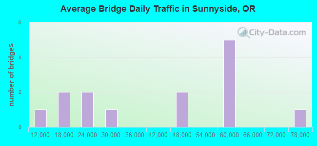
- 564,809Total average daily traffic
- 56,874Total average daily truck traffic
- National Bridge Inventory (NBI) Registered Bridges for Sunnyside
- No street view available for this location
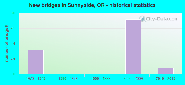
- New bridges - historical statistics
- 41970-1979
- 92000-2009
- 12010-2019
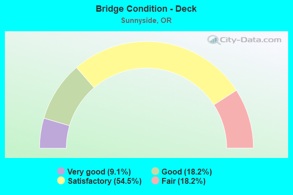
- Bridge Condition - Deck
- 9.1%Very good
- 18.2%Good
- 54.5%Satisfactory
- 18.2%Fair
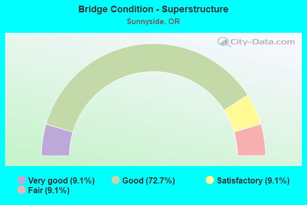
- Bridge Condition - Superstructure
- 9.1%Very good
- 72.7%Good
- 9.1%Satisfactory
- 9.1%Fair
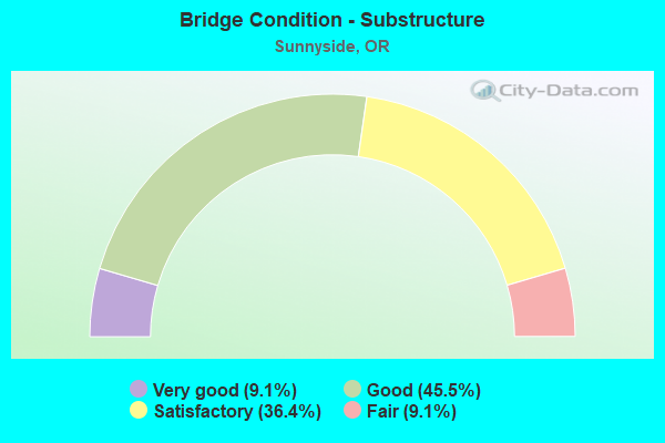
- Bridge Condition - Substructure
- 9.1%Very good
- 45.5%Good
- 36.4%Satisfactory
- 9.1%Fair
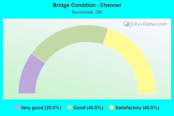
- Bridge Condition - Channel
- 20.0%Very good
- 40.0%Good
- 40.0%Satisfactory
Find on map >> Show street view
Structure Number: 9715 064C01458, Location: 2.1 MI S OF PORTLAND SCL (Lat: 45.433300, Lng: -122.566150), Route carried "on" structure: Business City street 205, Year Built: 1973, Status: Open, Structure Length: 9.75m (31.99ft), Average Daily Traffic: 58,129 (year 2020), Truck Traffic: 10%, Average Future Daily Traffic: 161,800 (year 2040), Design Load: HS 20, Features Intersected: Hwy 064, Facility Carried by Structure: Sunnyside Rd
Minimum Vertical Clearance: 30+ m (98+ ft), Kilometerpoint: 23.464, Lanes on structure: 5, Lanes under structure: 7, Owner: State Highway Agency, Approaching Roadway Width: 21.9m (71.9ft), Skew: 1 degrees, Material/Design: Prestressed concrete continuous, Design/Construction: Box Beam or Girders - Multiple, Number Of Spans In Main Unit: 2, Length of Maximum Span: 50.3m (165.0ft), Curb or Sidewalk Widths: Left: 1.5m (4.9ft), Right: 1.5m (4.9ft), Curb-To-Curb Width: 21.9m (71.9ft), Out-to-Out Width: 26.3m (86.3ft)
Condition: Deck: Satisfactory, Superstructure: Fair, Substructure: Satisfactory, Operating Rating: 64.5 metric tons, Method Used To Determine Operating Rating: Load and Resistance Factor Rating (LRFR) rating reported by rating factor(RF) method using HL-93 loadings, Inventory Rating: 49.9 metric tons, Method Used To Determine Inventory Rating: Load and Resistance Factor Rating (LRFR) rating reported by rating factor(RF) method using HL-93 loadings, Structural Evaluation: Somewhat better than minimum adequacy, Deck Geometry: Somewhat better than minimum adequacy, Underclear: Equal to present minimum criteria, Approach Roadway Alignment: Equal to present desirable criteria, Designated Inspection Frequency: Every 24 months, Inspection Date: March 2021, Deck Structure Type: Concrete Cast-file-Place, Wearing Surface/Protective System: Wearing Surface: Monolithic Concrete
Find on map >> Show street view
Structure Number: 9717 064 01376, Location: 4.6 MI N OF OREGON CITY (Lat: 45.422072, Lng: -122.570992), Route carried "on" structure: Interstate 205, Year Built: 1973, Status: Open, Structure Length: 9.14m (29.99ft), Average Daily Traffic: 47,511 (year 2020), Truck Traffic: 10%, Average Future Daily Traffic: 58,450 (year 2040), Design Load: HS 20, Features Intersected: UPRR, Facility Carried by Structure: Hwy 064 NB
Minimum Vertical Clearance: 30+ m (98+ ft), Kilometerpoint: 22.145, Lanes on structure: 3, Base Highway Network: Yes, Owner: State Highway Agency, Approaching Roadway Width: 18.3m (60.0ft), Skew: 3 degrees, Material/Design: Prestressed concrete, Design/Construction: Stringer/Multi-beam, Number Of Spans In Main Unit: 4, Length of Maximum Span: 28.0m (91.9ft), Curb-To-Curb Width: 18.3m (60.0ft), Out-to-Out Width: 19.4m (63.6ft)
Condition: Deck: Good, Superstructure: Good, Substructure: Satisfactory, Operating Rating: 22.0 metric tons, Method Used To Determine Operating Rating: Load and Resistance Factor Rating (LRFR) rating reported by rating factor(RF) method using HL-93 loadings, Inventory Rating: 16.8 metric tons, Method Used To Determine Inventory Rating: Load and Resistance Factor Rating (LRFR) rating reported by rating factor(RF) method using HL-93 loadings, Structural Evaluation: Meets minimum limits, Deck Geometry: Better than present minimum criteria, Underclear: Superior to present desirable criteria, Approach Roadway Alignment: Equal to present desirable criteria, Designated Inspection Frequency: Every 24 months, Inspection Date: March 2021, Deck Structure Type: Concrete Cast-file-Place, Wearing Surface/Protective System: Wearing Surface: Latex Concrete
Find on map >> Show street view
Structure Number: 9717A064 01376, Location: 4.6 MI N OF OREGON CITY (Lat: 45.422467, Lng: -122.571211), Route carried "on" structure: Interstate 205, Year Built: 1973, Status: Open, Structure Length: 9.14m (29.99ft), Average Daily Traffic: 47,511 (year 2020), Truck Traffic: 10%, Average Future Daily Traffic: 58,450 (year 2040), Design Load: HS 20, Features Intersected: UPRR, Facility Carried by Structure: Hwy 064 SB
Minimum Vertical Clearance: 30+ m (98+ ft), Kilometerpoint: 22.145, Lanes on structure: 4, Base Highway Network: Yes, Owner: State Highway Agency, Approaching Roadway Width: 22.2m (72.8ft), Skew: 3 degrees, Material/Design: Prestressed concrete, Design/Construction: Stringer/Multi-beam, Number Of Spans In Main Unit: 4, Length of Maximum Span: 28.0m (91.9ft), Curb-To-Curb Width: 18.8m (61.7ft), Out-to-Out Width: 18.8m (61.7ft)
Condition: Deck: Satisfactory, Superstructure: Good, Substructure: Satisfactory, Operating Rating: 19.4 metric tons, Method Used To Determine Operating Rating: Load and Resistance Factor Rating (LRFR) rating reported by rating factor(RF) method using HL-93 loadings, Inventory Rating: 14.9 metric tons, Method Used To Determine Inventory Rating: Load and Resistance Factor Rating (LRFR) rating reported by rating factor(RF) method using HL-93 loadings, Structural Evaluation: High priority of corrective action, Deck Geometry: Meets minimum limits, Underclear: Superior to present desirable criteria, Approach Roadway Alignment: Equal to present desirable criteria, Length Of Structure Improvement: 9.10m (29.86ft), Designated Inspection Frequency: Every 24 months, Inspection Date: March 2021, Bridge Improvement Cost: $961,000, Roadway Improvement Cost: $96,000, Total Project Cost: $1,537,000, Deck Structure Type: Concrete Cast-file-Place, Wearing Surface/Protective System: Wearing Surface: Latex Concrete
Find on map >> Show street view
Structure Number: 17118 064C01432, Location: 2.4 MI S OF PORTLAND SCL (Lat: 45.429489, Lng: -122.565839), Route carried "on" structure: Business City street , Year Built: 2003, Status: Open, Structure Length: 7.55m (24.77ft), Average Daily Traffic: 58,129 (year 2020), Truck Traffic: 10%, Average Future Daily Traffic: 161,800 (year 2040), Design Load: HS 25 or greater, Features Intersected: Hwy 064, Facility Carried by Structure: Sunnybrook Rd
Minimum Vertical Clearance: 30+ m (98+ ft), Kilometerpoint: 23.046, Lanes on structure: 6, Lanes under structure: 7, Owner: State Highway Agency, Approaching Roadway Width: 29.4m (96.5ft), Material/Design: Prestressed concrete continuous, Design/Construction: Box Beam or Girders - Multiple, Number Of Spans In Main Unit: 2, Length of Maximum Span: 40.0m (131.2ft), Curb or Sidewalk Widths: Left: 2.6m (8.5ft), Right: 2.6m (8.5ft), Curb-To-Curb Width: 29.4m (96.5ft), Out-to-Out Width: 35.2m (115.5ft)
Condition: Deck: Satisfactory, Superstructure: Satisfactory, Substructure: Good, Operating Rating: 34.0 metric tons, Method Used To Determine Operating Rating: Load and Resistance Factor Rating (LRFR) rating reported by rating factor(RF) method using HL-93 loadings, Inventory Rating: 26.2 metric tons, Method Used To Determine Inventory Rating: Load and Resistance Factor Rating (LRFR) rating reported by rating factor(RF) method using HL-93 loadings, Structural Evaluation: Equal to present minimum criteria, Deck Geometry: Superior to present desirable criteria, Underclear: High priority of corrective action, Approach Roadway Alignment: Equal to present desirable criteria, Designated Inspection Frequency: Every 24 months, Inspection Date: March 2021, Deck Structure Type: Concrete Cast-file-Place, Wearing Surface/Protective System: Wearing Surface: Monolithic Concrete, Deck Protection: Epoxy Coated Reinforcing
Find on map >> Show street view
Structure Number: 17258 064C01423, Location: 2.4 MI S OF PORTLAND SCL (Lat: 45.428089, Lng: -122.565739), Route carried "on" structure: Business City street 205, Year Built: 2003, Status: Open, Structure Length: 13.00m (42.65ft), Average Daily Traffic: 29,064 (year 2020), Truck Traffic: 10%, Average Future Daily Traffic: 80,900 (year 2040), Design Load: HS 25 or greater, Features Intersected: Mt Scott Creek, Facility Carried by Structure: Hwy 064 Conn
Minimum Vertical Clearance: 30+ m (98+ ft), Kilometerpoint: 22.901, Lanes on structure: 2, Base Highway Network: Yes, Owner: State Highway Agency, Approaching Roadway Width: 10.8m (35.4ft), Material/Design: Prestressed concrete continuous, Design/Construction: Box Beam or Girders - Multiple, Number Of Spans In Main Unit: 3, Length of Maximum Span: 50.0m (164.0ft), Curb-To-Curb Width: 10.8m (35.4ft), Out-to-Out Width: 11.6m (38.1ft)
Condition: Deck: Good, Superstructure: Good, Substructure: Satisfactory, Channel: Very good, Operating Rating: 32.7 metric tons, Method Used To Determine Operating Rating: Load and Resistance Factor Rating (LRFR) rating reported by rating factor(RF) method using HL-93 loadings, Inventory Rating: 25.3 metric tons, Method Used To Determine Inventory Rating: Load and Resistance Factor Rating (LRFR) rating reported by rating factor(RF) method using HL-93 loadings, Structural Evaluation: Equal to present minimum criteria, Deck Geometry: Meets minimum limits, Waterway Adequacy: Equal to present desirable criteria, Approach Roadway Alignment: Equal to present desirable criteria, Designated Inspection Frequency: Every 24 months, Inspection Date: March 2021, Deck Structure Type: Concrete Cast-file-Place, Wearing Surface/Protective System: Wearing Surface: Monolithic Concrete, Deck Protection: Epoxy Coated Reinforcing
Find on map >> Show street view
Structure Number: 18309, Location: .25 M S OF SUNNYSIDE ROAD (Lat: 45.428689, Lng: -122.563069), Route carried "on" structure: County highway , Year Built: 2001, Status: Open, Structure Length: 2.12m (6.96ft), Average Daily Traffic: 8,094 (year 2020), Truck Traffic: 5%, Average Future Daily Traffic: 8,927 (year 2025), Design Load: HS 25 or greater, Features Intersected: MT SCOTT CREEK, Facility Carried by Structure: 97TH AVE
Minimum Vertical Clearance: 30+ m (98+ ft), Kilometerpoint: 0.467, Lanes on structure: 3, Owner: County Highway Agency, Approaching Roadway Width: 19.2m (63.0ft), Skew: 4 degrees, Material/Design: Prestressed concrete, Design/Construction: Stringer/Multi-beam, Number Of Spans In Main Unit: 1, Length of Maximum Span: 21.0m (68.9ft), Curb or Sidewalk Widths: Left: 2.6m (8.5ft), Right: 2.6m (8.5ft), Curb-To-Curb Width: 19.2m (63.0ft), Out-to-Out Width: 25.2m (82.7ft)
Condition: Deck: Fair, Superstructure: Good, Substructure: Fair, Channel: Satisfactory, Operating Rating: 71.7 metric tons, Method Used To Determine Operating Rating: Load Factor (LF), Inventory Rating: 42.6 metric tons, Method Used To Determine Inventory Rating: Load Factor (LF), Structural Evaluation: Somewhat better than minimum adequacy, Deck Geometry: Superior to present desirable criteria, Waterway Adequacy: Equal to present desirable criteria, Approach Roadway Alignment: Equal to present desirable criteria, Designated Inspection Frequency: Every 24 months, Inspection Date: May 2021, Deck Structure Type: Concrete Cast-file-Place, Wearing Surface/Protective System: Wearing Surface: Monolithic Concrete, Deck Protection: Epoxy Coated Reinforcing
Find on map >> Show street view
Structure Number: 1831, Location: SOUTH OF SUNNYSIDE ROAD (Lat: 45.430500, Lng: -122.558689), Route carried "on" structure: County highway , Year Built: 2001, Status: Open, Structure Length: 1.53m (5.02ft), Average Daily Traffic: 12,215 (year 2020), Truck Traffic: 5%, Average Future Daily Traffic: 12,965 (year 2025), Design Load: HS 25 or greater, Features Intersected: UNKNOWN CREEK, Facility Carried by Structure: SUNNYBROOK ST (W)
Minimum Vertical Clearance: 30+ m (98+ ft), Kilometerpoint: 2.044, Lanes on structure: 4, Owner: County Highway Agency, Approaching Roadway Width: 18.3m (60.0ft), Skew: 20 degrees, Material/Design: Prestressed concrete, Design/Construction: Stringer/Multi-beam, Number Of Spans In Main Unit: 1, Length of Maximum Span: 15.0m (49.2ft), Curb or Sidewalk Widths: Left: 0.0m, Right: 2.6m (8.5ft), Curb-To-Curb Width: 18.3m (60.0ft), Out-to-Out Width: 25.6m (84.0ft)
Condition: Deck: Satisfactory, Superstructure: Good, Substructure: Good, Channel: Good, Operating Rating: 55.3 metric tons, Method Used To Determine Operating Rating: Load Factor (LF), Inventory Rating: 32.7 metric tons, Method Used To Determine Inventory Rating: Load Factor (LF), Structural Evaluation: Better than present minimum criteria, Deck Geometry: Somewhat better than minimum adequacy, Waterway Adequacy: Equal to present desirable criteria, Approach Roadway Alignment: Equal to present desirable criteria, Designated Inspection Frequency: Every 24 months, Inspection Date: May 2021, Deck Structure Type: Concrete Cast-file-Place, Wearing Surface/Protective System: Wearing Surface: Monolithic Concrete, Deck Protection: Epoxy Coated Reinforcing
Find on map >> Show street view
Structure Number: 18311, Location: EAST END OF SUNNYBROOK RD (Lat: 45.431819, Lng: -122.553431), Route carried "on" structure: County highway , Year Built: 2001, Status: Open, Structure Length: 2.43m (7.97ft), Average Daily Traffic: 12,215 (year 2020), Truck Traffic: 5%, Average Future Daily Traffic: 12,965 (year 2025), Design Load: HS 25 or greater, Features Intersected: UNKNOWN CREEK, Facility Carried by Structure: SUNNYBROOK ST (E)
Minimum Vertical Clearance: 30+ m (98+ ft), Kilometerpoint: 1.609, Lanes on structure: 4, Owner: County Highway Agency, Approaching Roadway Width: 18.3m (60.0ft), Skew: 20 degrees, Material/Design: Prestressed concrete, Design/Construction: Stringer/Multi-beam, Number Of Spans In Main Unit: 1, Length of Maximum Span: 24.0m (78.7ft), Curb or Sidewalk Widths: Left: 0.0m, Right: 2.6m (8.5ft), Curb-To-Curb Width: 18.3m (60.0ft), Out-to-Out Width: 25.6m (84.0ft)
Condition: Deck: Satisfactory, Superstructure: Good, Substructure: Good, Channel: Satisfactory, Operating Rating: 58.1 metric tons, Method Used To Determine Operating Rating: Load Factor (LF), Inventory Rating: 35.4 metric tons, Method Used To Determine Inventory Rating: Load Factor (LF), Structural Evaluation: Better than present minimum criteria, Deck Geometry: Somewhat better than minimum adequacy, Waterway Adequacy: Better than present minimum criteria, Approach Roadway Alignment: Equal to present desirable criteria, Designated Inspection Frequency: Every 24 months, Inspection Date: May 2021, Deck Structure Type: Concrete Cast-file-Place, Wearing Surface/Protective System: Wearing Surface: Monolithic Concrete, Deck Protection: Epoxy Coated Reinforcing
Find on map >> Show street view
Structure Number: 18596 064 01494, Location: 1.63 MI S OF PORTLAND SCL (Lat: 45.438361, Lng: -122.567939), Route carried "on" structure: City street , Year Built: 2002, Status: Open, Structure Length: 11.55m (37.89ft), Average Daily Traffic: 58,129 (year 2020), Truck Traffic: 10%, Average Future Daily Traffic: 161,800 (year 2040), Design Load: HS 25 or greater, Features Intersected: Hwy 064, Facility Carried by Structure: Monterey Ave
Minimum Vertical Clearance: 30+ m (98+ ft), Kilometerpoint: 23.979, Lanes on structure: 3, Lanes under structure: 9, Owner: State Highway Agency, Approaching Roadway Width: 15.0m (49.2ft), Skew: 1 degrees, Material/Design: Prestressed concrete continuous, Design/Construction: Box Beam or Girders - Multiple, Number Of Spans In Main Unit: 2, Length of Maximum Span: 61.0m (200.1ft), Curb or Sidewalk Widths: Left: 1.8m (5.9ft), Right: 1.8m (5.9ft), Curb-To-Curb Width: 15.0m (49.2ft), Out-to-Out Width: 19.1m (62.7ft)
Condition: Deck: Satisfactory, Superstructure: Good, Substructure: Good, Operating Rating: 42.1 metric tons, Method Used To Determine Operating Rating: Load and Resistance Factor Rating (LRFR) rating reported by rating factor(RF) method using HL-93 loadings, Inventory Rating: 32.4 metric tons, Method Used To Determine Inventory Rating: Load and Resistance Factor Rating (LRFR) rating reported by rating factor(RF) method using HL-93 loadings, Structural Evaluation: Better than present minimum criteria, Deck Geometry: Equal to present minimum criteria, Underclear: Equal to present minimum criteria, Approach Roadway Alignment: Equal to present desirable criteria, Designated Inspection Frequency: Every 24 months, Inspection Date: March 2021, Deck Structure Type: Concrete Cast-file-Place, Wearing Surface/Protective System: Wearing Surface: Monolithic Concrete, Deck Protection: Epoxy Coated Reinforcing
Find on map >> Show street view
Structure Number: 19879, Location: 1.16 MI E OF I-205 (Lat: 45.431319, Lng: -122.542950), Route carried "on" structure: County highway , Year Built: 2003, Status: Open, Structure Length: 4.19m (13.75ft), Average Daily Traffic: 22,059 (year 2020), Truck Traffic: 5%, Average Future Daily Traffic: 23,616 (year 2025), Design Load: HS 25 or greater, Features Intersected: MT SCOTT CREEK, Facility Carried by Structure: SUNNYSIDE RD
Minimum Vertical Clearance: 30+ m (98+ ft), Kilometerpoint: 2.881, Lanes on structure: 6, Owner: County Highway Agency, Approaching Roadway Width: 25.0m (82.0ft), Skew: 20 degrees, Material/Design: Prestressed concrete, Design/Construction: Stringer/Multi-beam, Number Of Spans In Main Unit: 1, Length of Maximum Span: 41.5m (136.2ft), Curb or Sidewalk Widths: Left: 1.8m (5.9ft), Right: 1.8m (5.9ft), Curb-To-Curb Width: 25.0m (82.0ft), Out-to-Out Width: 33.7m (110.6ft)
Condition: Deck: Fair, Superstructure: Good, Substructure: Good, Channel: Good, Operating Rating: 64.2 metric tons, Method Used To Determine Operating Rating: Load and Resistance Factor Rating (LRFR) rating reported by rating factor(RF) method using HL-93 loadings, Inventory Rating: 49.6 metric tons, Method Used To Determine Inventory Rating: Load and Resistance Factor Rating (LRFR) rating reported by rating factor(RF) method using HL-93 loadings, Structural Evaluation: Better than present minimum criteria, Deck Geometry: Somewhat better than minimum adequacy, Waterway Adequacy: Equal to present desirable criteria, Approach Roadway Alignment: Equal to present desirable criteria, Designated Inspection Frequency: Every 24 months, Inspection Date: May 2021, Deck Structure Type: Concrete Cast-file-Place, Wearing Surface/Protective System: Wearing Surface: Monolithic Concrete, Deck Protection: Epoxy Coated Reinforcing
Find on map >> Show street view
Structure Number: 21870 075 00008, Location: Sunrise Coord. MP 0.80 (Lat: 45.415778, Lng: -122.564700), Route carried "on" structure: State highway 213, Year Built: 2015, Status: Open, Structure Length: 1.38m (4.53ft), Average Daily Traffic: 18,249 (year 2020), Truck Traffic: 6%, Average Future Daily Traffic: 22,900 (year 2040), Design Load: HL 93, Features Intersected: Private Streetcar Track, Facility Carried by Structure: Hwy 075
Minimum Vertical Clearance: 30.45m (99.90ft), Kilometerpoint: 1.287, Lanes on structure: 4, Owner: State Highway Agency, Approaching Roadway Width: 21.9m (71.9ft), Skew: 23 degrees, Material/Design: Prestressed concrete, Design/Construction: Slab, Number Of Spans In Main Unit: 1, Length of Maximum Span: 13.8m (45.3ft), Curb-To-Curb Width: 21.9m (71.9ft), Out-to-Out Width: 23.2m (76.1ft)
Condition: Deck: Very good, Superstructure: Very good, Substructure: Very good, Operating Rating: 89.7 metric tons, Method Used To Determine Operating Rating: Load and Resistance Factor Rating (LRFR) rating reported by rating factor(RF) method using HL-93 loadings, Inventory Rating: 69.0 metric tons, Method Used To Determine Inventory Rating: Load and Resistance Factor Rating (LRFR) rating reported by rating factor(RF) method using HL-93 loadings, Structural Evaluation: Equal to present desirable criteria, Deck Geometry: Superior to present desirable criteria, Underclear: High priority of corrective action, Approach Roadway Alignment: Equal to present desirable criteria, Designated Inspection Frequency: Every 24 months, Inspection Date: September 2020, Deck Structure Type: Concrete Precast Panels, Wearing Surface/Protective System: Wearing Surface: Integral Concrete, Deck Protection: Epoxy Coated Reinforcing
Find on map >> Show street view
Structure Number: 9715 064C01458, Location: 2.1 MI S OF PORTLAND SCL (Lat: 45.433300, Lng: -122.566150), Route carried "under" structure: Interstate 205, Year Built: 1973, Structure Length: 0. m, Average Daily Traffic: 58,129 (year 2020), Truck Traffic: 10%, Features Intersected: Hwy 064, Facility Carried by Structure: Sunnyside Rd
Minimum Vertical Clearance: 5.72m (18.77ft), Kilometerpoint: 23.464, Lanes on structure: 5, Lanes under structure: 7, Material/Design: Prestressed concrete continuous, Design/Construction: Box Beam or Girders - Multiple, Length of Maximum Span: 50.3m (165.0ft)
Find on map >> Show street view
Structure Number: 17118 064C01432, Location: 2.4 MI S OF PORTLAND SCL (Lat: 45.429489, Lng: -122.565839), Route carried "under" structure: Interstate 205, Year Built: 2003, Structure Length: 0. m, Average Daily Traffic: 77,246 (year 2020), Truck Traffic: 15%, Features Intersected: Hwy 064, Facility Carried by Structure: Sunnybrook Rd
Minimum Vertical Clearance: 6.17m (20.24ft), Kilometerpoint: 0.000, Lanes on structure: 6, Lanes under structure: 7, Material/Design: Prestressed concrete continuous, Design/Construction: Box Beam or Girders - Multiple, Length of Maximum Span: 40.0m (131.2ft)
Find on map >> Show street view
Structure Number: 18596 064 01494, Location: 1.63 MI S OF PORTLAND SCL (Lat: 45.438361, Lng: -122.567939), Route carried "under" structure: Interstate 205, Year Built: 2002, Structure Length: 0. m, Average Daily Traffic: 58,129 (year 2020), Truck Traffic: 10%, Features Intersected: Hwy 064, Facility Carried by Structure: Monterey Ave
Minimum Vertical Clearance: 6.32m (20.73ft), Kilometerpoint: 24.044, Lanes on structure: 3, Lanes under structure: 9, Material/Design: Prestressed concrete continuous, Design/Construction: Box Beam or Girders - Multiple, Length of Maximum Span: 61.0m (200.1ft)